
a treasure-trove of literature
treasure found hidden with no evidence of ownership
(and our other authors) or get HELP Reading, Downloading and Converting files)
or
SEARCH the entire site with Google Site Search
|
Project Gutenberg
Australia a treasure-trove of literature treasure found hidden with no evidence of ownership |
BROWSE the site for other works by this author (and our other authors) or get HELP Reading, Downloading and Converting files) or SEARCH the entire site with Google Site Search |
Title: The Discovery of Bass Strait
Author: George Bass
A Project Gutenberg of Australia eBook
eBook No.: 1300051h.html
Language: English
Date first posted: January 2013
Date most recently updated: January 2013
Produced by:Ned Overton
Project Gutenberg of Australia eBooks are created from printed editions which are in the public domain in Australia, unless a copyright notice is included. We do not keep any eBooks in compliance with a particular paper edition.
Copyright laws are changing all over the world. Be sure to check the copyright laws for your country before downloading or redistributing this file.
This eBook is made available at no cost and with almost no restrictions whatsoever. You may copy it, give it away or re-use it under the terms of the Project Gutenberg of Australia Licence which may be viewed online.
GO TO Project Gutenberg Australia HOME PAGE
Production Notes:
In this format, it has not been feasible to preserve the
individual page titles, paragraph headlines or dates in the
margin.
The only additions to the original are:
* A CONTENTS page;
* The first footnote relabelled as Biographical Note;
* Heading for the Journal, and sub-headings for each of the three
months of the expedition's duration;
* Flinders' map of his and Bass's voyages (see reference) at the
beginning.
* Punctuation has been updated in a few instances.
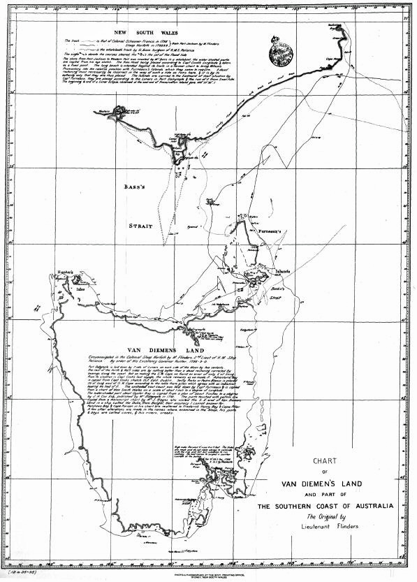
Flinders's map of his and Bass's voyages.
From page 767 of HISTORICAL RECORDS OF N.S.W., Volume
3—Hunter 1796-1799, APPENDIX B.
By Authority.
SYDNEY: CHARLES POTTER, GOVERNMENT PRINTER.
——
1895.
[REGISTERED UNDER THE COPYRIGHT ACT,
1879.]
[Printed from a manuscript in the possession of the Hon. P. G. King, M.L.C.]
George Bass, surgeon of H.M.S. Reliance, was permitted by Hunter to take six seamen and six weeks' provisions in a whaleboat, to explore the coast south of Sydney. He was absent twelve weeks, and before his return demonstrated the existence of a strait between Tasmania and Australia. At the time he undertook this journey he was thirty-four years of age, and was described by his father-in-law in a letter to the British Government, written, it is supposed, in 1813, as "Six foot high, dark complexion, wears spectacles, a very penetrating countenance." In February, 1803, he sailed from Port Jackson in the brig Venus, for South America, to procure salt meat and live cattle for the settlement. He informed his brother-in-law, Captain Waterhouse, of H.M S. Reliance, in a letter, written a few hours before he sailed on the voyage from which he was destined never to return, that he proposed to call in at Dusky Bay, New Zealand, where the wreck of the Endeavour lay; then proceed for sealskins to the islands lying farther south, and finally, to make the coast of Chili in search of provisions, &c., for New South Wales. With this last object in view, he informed Waterhouse that he had been provided by Governor King with a "very diplomatic-looking certificate". Amongst a number of papers in the possession of Mr. Pownall, solicitor, of Russell Square, London, is the following statement:—
"London, May 10th, 1811.
"In or about the year 1803, a brig named the Harrington, Captain William Campbell, master, arrived at Port Jackson from the coast of Peru, and brought intelligence that the Venus had been taken by the Spaniards that Mr. G. Bass and Mr. Scott, mate, had, together with the crew, been sent either to the mines or further inland. A Spanish gentleman with whom Captain Campbell was trading told him that Mr. Bass was taken when landing in his boat, and that the vessel was seized afterwards. Captain Campbell had been to Quito, to Valparaiso, and to Valdivia; but it is uncertain at which of those places the affair happened."
Endorsed upon the back of the foregoing statement is the following memorandum in another hand:—
"Lieut't Fitzmaurice was at Valparaiso and St. Jago de Chili in the months of September and October, 1808, and at Lima from November following till April of the next year. The whole of the British prisoners remaining in the Vice-Royalties of Peru and Chili, and the Provinces of Conception, were released, and sent to Europe.
"If such a person had been taken at Valdivia, he would have been sent to one of the abovementioned places.
"A person of the name of Bass, as well as I can recollect, I heard of being in Lima, five or six years before I went there.
WM. FITZMAURICE."
The following letter, the original of which is in the Record Office in London, throws some light on the probable fate of this unfortunate navigator:—
"Liverpool, New South Wales, 10th December, 1817.
"I have just heard a report that Mr. Bass is alive yet in South America. A captn. of a vessel belonging to this port, trading among the islands to the east, fell in with a whaler, and the captn. informed he had seen such a person, and described the person of Mr. Bass. The captn. of a vessel out of this port knowing Mr. Bass well, he is of a belief, the description that the master of the whaler gives of him, it's certainly Mr. Bass—being a doctor too—which is still a stronger reason.
I am, &c., THOS. MOORE.
Some interesting particulars concerning Bass's early life are given in Sidney's "Three Colonies of Australia." p. 60 (note).
It will be noticed that Bass makes no allusion in this journal to the seven escaped convicts whom Collins states (vol. ii, p. 94) he found on an island when returning to Port Jackson.
Sunday, Decr. 3rd.—At 6 p.m. we rowed out between the Heads, and finding the wind at N.E. by E. set the sails and stood to the southward. At 9 we anchored in Little Harbour,* three miles on this side of Botany Bay, for the night looked squally and uncertain, and things had not yet found their proper places in the boat.
[* Now known as Little Bay.]
At 5 a.m.** we sailed to the southward with a light breeze at north. At 8, when within 3 or 4 miles of Watamowley, the wind, after wavering about for some time, flew round to W.S.W. and blew violently; we therefore took in the sails and pulled in under the cliffs in expectation of reaching Watamowley, but the wind coining round further to the southward we bore up and went into Port Hacking.
[** In following Bass's movements, it must be borne in mind that the times given in this journal are those of the nautical day, which was reckoned from noon to noon.]
Monday, 4th.—P.M.: Gales at W.S.W. A.M. 5: Being moderate, we sailed, but at 8 the wind headed in flurries; we therefore went into Watamowley, being then abreast of it.
Tuesday, 5th.—P.M.: At 1 sailed with a fresh sea-breeze at N.E., and at sunset passed the five islands laying off Hat Hill. It was calm all night, but in the morning we stood along the land with a light air almost at east, which continued until noon, when our latitude was 34° 36'.
Wednesday, 6th.—P.M.: At 1 the air of wind freshened up into a breeze, and at the same time southerned so much that we could not lay along the land; we therefore went into a bight and anchored.***
[*** Evidently the bight of which Point Bass forms the southern extremity.]
The shore in this bight, and also for some distance on each side of it, bears evident marks of volcanic fire. Several of the little heads and points are of a basaltic nature; some irregular, others columnar basaltis. Upon landing, I perceived, near the extremity of one of the heads, the rocks laving scattered about in a very irregular manner, and upon examination it appeared that a volcanic eruption had formerly taken place there. The earth for a considerable distance round, in a form approaching to that of a circle, seemed to have given way; it was now a green slope.
Towards the centre was a deep ragged hole of about 25 or 30 feet in diameter, and on one side of it the sea washed in through a subterraneous passage with a most tremendous noise. The pieces of rock that lay scattered about had all been burnt, but some were in a state of scoria.
Nothing can be said as to the soil, for the easternmost part of the Blue Mountains comes to the sea here.* At 10 p.m., the wind coming at east, we stood to the southward.
[* This range of mountains, which Bass regarded as a continuance of the Blue Mountains, is now known as the Illawarra Range, and runs in a N.E. direction from Kangaloon to the coast-line near Coal Cliff.]
Thursday, 7th.—P.M: At 1 passed Long Nose Point, to the southward of which the coast bights backs considerably to the westward, and forms a long bay, whose southern extremity is terminated by Cape St. George.**
[** Captain Cook first sighted the cape now known as Cape St. George on 24th April, 1770. Hawkesworth (vol. iii, p. 487) states that the name given to the point was Cape George; but in all Cook's maps, and in that which Hawkesworth published, it appears as Cape St. George.]
At 5, seeing an opening in the bottom of the bay,*** we judged it to be an inlet, and ran down to it, but found it to be a shallow lagoon, with a bar breaking all across the mouth; we therefore rowed on along the bay for a rocky projecting point that promised fair for affording shelter, and at 6 came up with it, and found a small river, into which we went. This little place, which deserves no better a name than Shoals Haven, for it is not properly a river, is very narrow at the entrance, the south side of which is formed by the rocky point, and the north by a breaking spit of sand that runs out from a sandy point; within it widens, but the channel, though deep, is very small, the greater part being filled up by shoals of mud and sand.
[*** It will be seen by the memorandum at the conclusion of this journal (post, p. 332) that Bass had been misled by Bowen's calculations. The point Bass here refers to as Long Nose Point is evidently that at the northern extremity of Seven-mile Beach.]
The country round it is in general low and swampy, and the soil for the most part is rich and good, but seemingly much subject to extensive inundations.
There are, however, at 6 or 8 miles back from the head of the west branch, many thousand acres of open ground which never can be overflowed, whose soil is a rich vegetable mould.
These extensive openings must formerly have been swamps, but now filled up by repeated floodings and the annual decay of vegetable growth.
Patches and points of trees, the islands, and points of the former swamps still remain to shew what the country has once been. The vicinity of that body of mountains which we call the Blue Mountains does not a little contribute towards keeping this part of the low land wetter than it would otherwise be. From Long Nose Point they run inland about S.W., and form to the country here as complete a barrier to the north and west as they do at Port Jackson to the south and west. Here, indeed, their southern extremity—that is, that point of them which is formed by their turning off sharp to the north-west—is perfectly distinct, whereas there is every reason to believe that we are as completely shut in by them to the northward as to the southward, though that part has not yet been traced.
The Blue Mountains, in short, appear to be nothing more than a body of mountains that, getting up somewhere to the northward—where, we cannot tell, but not very far, I am well convinced, on the north side of Port Stephens, perhaps at Cape Hawke—run southerly in about a S.b.W. or S.S.W. direction as far as the Cow Pastures, and then turn away eastward and come to the sea 18 or 20 miles to the southward of Botany Bay. Their breadth where they come to the sea is about 25 or 30 miles, but I suspect that as they advance northward their breadth decreases.
During my examination of the country back of Shoals Haven I fell in with an arm of water that, upon tracing down to the sea, I found to be the main stream of the barred lagoon that we had in vain attempted to enter. It runs about 9 or 10 miles westward until it strikes upon the mountains laying S.W., and then enters them with high rocky banks similar to those of the Grose, Tench,* and George's Rivers, on this side the mountains. The south bank of this arm is a slip of soil exactly resembling the banks of the Hawkesbury. At its back lie the extensive plains already spoken of.
[* Now known as the Nepean River.]
However capable the soil of this country might, upon a more accurate investigation, be found to be of agricultural improvement, certain it is that the difficulty of shipping off the produce must ever remain a bar to its colonization. A nursery of cattle might perhaps be carried on here with advantage, and that sort of produce ships off itself.
The tide in Shoals Haven rises 7 or 8 feet, and flows full, and changes about half-past 8. The ebb shoots down strong. The latitude of it I made to be 34° 52'.
Sunday, 10th.—P.M.: ½ sailed to the southward with a strong breeze at N.E. At 2 passed Cape St. George, in which I suspect there is a vein of coal, but altho' I took some pains when at Port Jervis to get down upon the face of the cliff, yet I never could approach near enough to ascertain whether it was coal or only slate.
At 3 entered Jervis Bay. This is a wide open bay of a very unpromising appearance upon first entering it. On the north and N.E. side, from Point Perpendicular to Cuckold's Point,** the shore is steep rocks; one beach and a little cove, which, from being the only place we found fresh water in, I have called Freshwater Cove, excepted. There are two streams of water in this cove, and large holes like tanks, seemingly always full. Any launch might at half-tide fill her casks with a hose, baling it out of the tank into the mouth of the hose. Between Cuckold's Point, which is a long rocky point like an artificial pier, and the northernmost beach on this north side is what appears to be the most proper place for anchorage. Even here ships are not landlocked; but I conjecture, from a comparison of the large swell rolling into the mouth of the bay with the smoothness of the water in this anchoring-place at the time we were there, that they might at most or all times ride in safety, and even with ease to themselves and ground-tackling. The N.W., west, and south sides are all shoal beaches, with a heavy surf breaking upon them.
[** It will be seen from the memorandum attached to this journal that Cuckold's Point was identical with the Long Nose Point of Captain Cook.—Post, p. 332.]
Bowen's Island lies about a fourth of a mile from the south point of the bay, but nothing larger than boats can pass between, on account of reefs that run out from each and nearly join. Off a little beach upon the inner part of the island there appears to be shelter for shipping, with the wind as far round as S.E., in about 8 fathoms, on a firm sandy bottom.
The country round the bay is in general barren. The north side is rocky, brushy, and heathy. The west is low and swampy, but sandy. In patches of a few score acres the ground runs tolerably good, but these are distant from each other, and too much intersected by lagoons and salt swamps to promise any advantage by cultivation. The south is grassy and brushy, and might serve for the pasturage of cattle. The bay near its mouth seems at some past period to have undergone a change of form by the operation of volcanic fire. The rocks on the N.E. side bear strong marks of it, and being disposed in parallel layers, their declination from the horizontal line is sufficiently evident. Their fall has been to the westward. Great quantities of pumice-stone are lying scattered about to some distance along the shore. Bowen's Island has altogether suffered an alteration by the earth under its western side giving way. The parallel strata now make with the surface of the sea an angle of not less than 14 or 18 degrees.
The north part of the bay bights in so far that all the N.E. shore of it, together with the coast on northward as far as Cape St. George,* a distance of 14 or 15 miles, is nothing more than a very narrow-necked peninsula; the south part of the bottom of the bay, between Long Nose and Cape George, being not more than three or four hundred yards distant from the north part of Jervis Bay.
[* Bass, misled by Bowen's data, placed Cape St. George to the north instead of to the south of Jervis Bay.—Post, p. 332.]
In the sketch Capt. Bowen has given of this bay he lays down a conjectural river 10 or 11 miles north of Point Perpendicular. I walked over and examined this place, but found it to be only a deep notch in the cliff's, without landing-place or shelter for vessels of any kind.
Wednesday, 13th.—At 9 a.m. sailed, with a fresh N.E. sea-breeze. At noon our latitude was 35° 16', the Pidgeon House bearing west.
Thursday, 14th.—P.M.: Wind fresh, N.E. At 3 passed an island, laying S.E. from the Pidgeon House, upon which we observed a pole or stump sticking on so high and conspicuous a part that we had every reason to believe some shipwrecked persons had erected it there. There was too heavy and fiery a following sea for us to dare to haul up for it now; we therefore left it for our return.**
[** This apparently Brush Island, about sixteen miles north of Bateman's Bay.]
At 5 we entered Bateman Bay.
Bateman Bay falls far short of that respectable figure it makes in the charts, for its depth back is not more than a mile, and its length a mile and three-fourths or two miles. It has a high steep north head, behind which it runs in northerly about a fourth of a mile, but there is no shelter except merely from northerly winds. Even in the furthest corner there is too much surf upon the beach for any boat to lay without constant attendance.
The north and south sides are hilly. Grass grows tolerably luxuriant upon them, but they seem only fit for feeding cattle. The land on the west side is low and wet, but a few grassy risings might afford good sites. The vallies and the slopes of several of the little hills at some distance back are capable of cultivation, some of them to great advantage. The only difference remarkable in the vegetable productions is the increased size of the she and swamp oaks.
Friday, 15th.—P.M.: 10, sailed with a sea-breeze at E.N.E. At noon our latitude was 35° 43', two or three small islands lying close under the shore; bore west.
Saturday, 16th.—P.M.: At 7 anchored for the night under the lee of a point.
A.M.: Daylight, sailed with an air at west. At 6 the wind flew round to south, bore up, and laid the boat upon the end of a little beach under the same point we had started from.
Sunday, 17th.—P.M.: Employed in examining the country round about us. The form of the ground in general is either low and swampy or at once inclining to the mountainous, there being little or none upon a plane. The whole is intersected by extensive salt swamps and the arms of a branching lagoon that comes to the sea about a mile to the northward of the point.*** A ridge of low but hummocky hills is passing along to the southward, at the distance of about 8 or 9 miles back.
[*** It would appear from this that the point under which Bass anchored was that now known as Marka Point. It is situated about a mile to the south of the entrance of the large saltwater lagoon into which the Turos River empties itself. Bass in the course of this day passed unnoticed the entrance of the Moruya River.]
The qualities of the soil are but very indifferent. Some of the best of the low ground before you approach the edges of the swamps is thickly covered with long grass and fern, but the soil is sandy and light. A wet salt marsh then leads you down into the swamps. The sides of the hills where they do not rise up from the lake or swamp side very suddenly are really meadows, but these are few in number. The tops of some of the lower hills are well grassed, but the soil is too poor and sandy for cultivation.
The country seems to be at all times but sparingly watered, but it is now in a state of drought. In the course of our round of not less than 12 or 14 miles we could not find a drop of fresh water, altho' the heat of the day made us search for it with extreme eagerness. We met with numbers of native huts deserted, the cause of which appeared when we traced down their paths to the dried up waterholes they had dug in the very heart of the largest of the swamps. We saw here the only grey kangaroo we ever met with during our whole absence. The latitude of this point is 36° 00'.
A.M.: The wind came strong at N.N.W., therefore as soon as we had daylight enough to get the boat through the surf we launched her and proceeded on to the southward. At 11 passed Mount Dromedary. There is an island laying off this mount, of about 2 miles in circuit, and about the same distance from the main. At noon our latitude was 36° 23'.
Monday, 18th.—P.M.: 4, after falling away gradually to a light breeze at N.N.W., the wind suddenly burst out at south and blew hard; we therefore hauled in for a break in the land that we had just before bore away for. At 5 landed in a sheltered little beach at the mouth of an inlet that broke across. At 10 a.m., seeing the mouth of the inlet did not break, we went in and examined it. Were it not for the extreme shallowness of the bar this little inlet would be a complete harbour for small craft, but a small boat even must watch her times for going in. At high water there is not more than 8 or 9 feet. The upper part of this place is a kind of lagoon, or at least a flat, but the lower part downwards, as far as the bar, is one of the prettiest little harbours as to form that was perhaps ever seen. One would take it to have been intended as the model of some large deep harbour. Every small bight has its little white sandy beach, and every turning its firm rocky point, the depth of the water holding a corresponding proportion to the size of the model.
The ground round it as far as I examined is rocky and barren in front, and low and salt at the head of it.
I have named the place Barmouth Creek; its latitude by computation is about 36° 47'.
Tuesday, 19th.—A M.: Sailed at daylight with a light breeze at N.N.W.; at 7 rounded the north point of a bay which seemed capable of affording security for shipping. At 9, the sea-breeze coming at N.E., we continued sailing round the bay, and then stood away to the southward; for I thought it better to leave this bay for further examination at our return than lose a fair opportunity of getting to the southward.*
[* This was evidently Twofold Bay. See the entry under date 15th February, 1798.—Post, p. 329.]
Wednesday, 20th.—P.M.: Wind N.E. At 5, the wind coming at S.S.W., we anchored under the lee of a point, but could not land.
A.M.: Daylight, with a light air at north; 10, sea-breeze at E.N.E.; 11, passed Cape Howe; at noon our latitude 37° 30'.
Thursday, 21st.—P.M.: 5, landed in a little bight** upon the end of a little beach about a mile north of the Ram Head to fill as much water as we could cask, for as the coast was now very rapidly becoming more sandy and low as we advanced to the southward, and we had every reason to believe the country at this time to be everywhere unusually dry, I was under some apprehension that, unless we had a stock of water to serve for several days, we might be obliged to return to the northward from the difficulty of meeting with it, and so lose the object of our research.
[** Doubtless that now known as Wingan Inlet.]
Friday, 22nd.—A gale set in at S. W. b. W., which continued for ten days. The country here is in general low, sandy, and not without lagoons, yet in figure hilly, but the hills are little else than sand; they have indeed a patched covering of green which might deceive the eye at a distance, but the usual sterility of soil still prevails. The best I have been able to find is like what at Port Jackson is reckoned so favourable for potatoes, which is a mixture of sand with a very small proportion of vegetable earth.
The general productions are short deformed gum-trees, the tea-tree, some small shrubs, and patches of an almost impenetrable underwood of small brush, ground fern, and vines. The foliage of the underwood is rich and green, but the trees are far more dusky and brown than I have seen anywhere else. A luxuriant crop of grass may occasionally be found in places where the underwood has thinned off, but the soil is still the same. Where thick grass belly-high and fern plants are growing together one might expect a better soil, but it is only a blackish sand like the rest.
It is but very few miles that I have been able to penetrate into this close country, but by the sand patches, which when I ascended the Ram Head I could distinctly see peeping out of the sides of the back hills, I can conclude no otherwise than that the soil to a great distance inland is equally [as] poor as, if not worse than, that which I have already trodden over.
We had remarked at every stage from Jervis Bay to Barmouth Creek that the fresh water kept increasing both in badness and in difficulty of procuring it.
On this coast of almost mere sand we expected the difficulty to increase in a still greater proportion, but we were deceived, for there are here many little runs of excellent water that, draining out of the sandhills, trickle over the rocky spots at their feet or sink through the beaches into the sea.
Saturday, 30th.—The gale broke up, and we had a light breeze at E.N.E. The boat had never been beached all the time we had been here, for at high water the surf washed up over the beach to the foot of the sand-cliffs, but she lay off at an anchor in a place where, though a swell came in, no breaking-water could. When we attempted to weigh the anchor to go out we found it so completely buried in the sand that the boat could not lift it; we therefore waited till low water, and then attempted with our feet and with sticks to scrape away the sand from it, but in vain. We tried at the next low water, when the cable parted at the clinch, and after some further ineffectual attempts we gave it up as irrecoverable, unless that at our return the sand that the late gale had thrown into the corner should be by that time worked out again. The anchor was not buried less than 4 or 5 feet.
Sunday, 31st.—A.M.: Daylight, got out and steered along to the southward in anxious expectation, being now nearly come upon an hitherto unknown part of the coast. The wind was at E.N.E.; our course up till noon, when our latitude was 37° 42', was about W.S.W.; we had then run, according to our rough way of reckoning, about 30 miles, the land all the way being of nearly the same height as about the Ram Head—in front, long beaches at the bottom of bights of no great depth, lying between low rocky projecting points—there might be about three of these in the whole distance; in the buck land lay some short ridges of lumpy irregular hills at a little distance from the sea.
Monday, Jan. 1, 1798.—P.M.: The wind continued at E.N.E., and we steered along close in with the land. By 9 we supposed ourselves to have gone upon a nearly W.S.W. course about from 30 to 36 miles, but we here and there observed a draining of a current which increased the uncertainty. The land in the whole of this distance was nothing but a low beach—a very small hummock appeared indeed every now and then inland. There were many large smokes behind the beach, as we conjectured by the sides of lagoons, of which there was reason to believe the back country was full.
At 10, being bright moonlight and the sky without a cloud, we could see the land distinctly; it was still low and level. At 11.30 we lost the distinct sight, so as not to be able to judge of any gaps or breaks there might be in it; it was low, however, but a haze had arisen over it. At 12, the haze thickening, we could scarcely see the land at all. At 2 a.m., the sea becoming more hollow and lofty, we judged ourselves to be getting into shoal water, or that the beach was altering its direction; we therefore hauled out to S.W. b. S., having since 9 ran about S.W. 10 or 12 miles. At 3.10 sufficient day had broken in upon the sky for us to see the land; it was still low and level sand, and seemed to trend in nearly the direction of our course. At 7 we were surprised by the sight of high hummocky land right ahead, but at a considerable distance. We steered for it, but that did not oblige us to quit the beach, for it also appeared to be making the same way in nearly as straight a course as it was able. At noon our latitude was 38° 41'; the high land was now abreast of us; its northernmost end bore W. b. N., 2 or 3 miles. There were several small islands laying in various directions to the southward. Vast flights of petrels and other birds flying about us. Our course and distance since 3·10 had been about S.W. b. S. from 35 to 40 miles or more, the beach keeping by the side of us until within a few miles of the high land, where it bighted back in two or three places that had the appearance of inlets. I now found we had filled up the before unexplored space between what is called Point Hicks, a point we could not at all distinguish from the rest of the beach, and the land seen by Furneaux in latitude 39° 00', for this high hummocky land could be no other than the land seen by him.
Tuesday, 2nd.—P.M.: We stood in to the southward along by the high land, with the wind fresh at E.N.E. At 2 steered down for a large hummock, bearing S. ½ E., that had just risen out of the water, and from its being so much larger than the rest, I suppose might be the main continued on by very low land from the back part of Furneaux's Land. At 4 the hummock proved to be an island. Furneaux's Land, too, appeared like an island; we could see no land joining to it, either on the east or west sides. We continued standing on for the hummock island, expecting, as it seemed large, to get shelter there, or, perhaps, landing.
At 6 we anchored under its lee, but could not land. Vast numbers of petrels, gulls, and other birds were roosting upon it, and on the rocks were many seals with a remarkably long tapering neck and sharp-pointed head. At daylight, the wind being very strong at N.E. b. E., and apprehending we should not fetch Furneaux's Land, I judged it best to steer about S. ½ E. for the islands lying to the northward of Van Dieman's Land. Accordingly, we sailed, but at 6 the wind shifted to E. b. S., when I presently found from the sea that was going, and the lee way the boat was making by being obliged every now and then to launch her off to the westward before the heaviest of the breaking seas, that we should not fetch near the land we were steering for. I stood on, however, with an intention, as we were thus far from the main, to endeavour to make the north coast of Van Dieman's Land, and coasting it along to the eastward, return to the northward by Cape Barren. I had hopes too of being able to procure rice at the island* the Sydney Cove's wreck is laying on, and by that means be enabled to lengthen our stay from Port Jackson, which would in some measure do away the effects of the persecution we had so much experienced from foul winds. At noon our latitude was 39° 51', no land in sight. The south part of Furneaux's Land I computed to bear N.N.E. or N.E. b. N., the north part of Van Dieman's Land about S.S.E. or S.E. b. S. We were therefore at the back of the island laying to the southward of the Sisters, and might be distant from it about 20 or 26 miles or more.
[* Preservation Island.—Appendix A.[: Narrative of the Shipwreck of Captain Hamilton and the Crew of the Sydney Cove, pp. 757-768.]]
Wednesday, 3rd.—P.M.: We stood in south, the wind E. by S. At 3 the water was observed to gush in through the boat's side pretty plentifully near the water-line abaft. We had frequently remarked in the course of the morning how much looser the boat had become by the last two or three days' working. As there appeared to be some risque of a plank starting, I determined, notwithstanding the north part of Van Dieman's Land could now be at no very great distance, to stand back for Furneaux's Land, and coast along from it in which ever way the land might trend, for the state of the boat did not seem to allow of our quitting the shore with propriety. At 4 wore and stood to the northward, keeping the boat close to the wind. It was at this time so clear to the southward that we judged ourselves capable of seeing land a moderate height full 4 or 5 leagues, had there been any at that distance. From the time of the observation until this time we had steered due south at the rate of 2½ or 3 knots per hour; we must therefore now have been in the latitude 40° 00', at least.
At 6 the wind back to E.S.E., and by 9 blew hard. A great sea got up, and ran very hollow and irregular. We had a bad night of it, but the excellent qualities of the boat brought us through. Soon after daylight we saw the island we left the morning before, bearing N.E. b. E., 16 or 18 miles, and at 6 saw Furneaux's Land, and steered in for it. At noon no observation, there being too much sea flying about.
Thursday, 4th.—P.M.: At 2 we were standing in under the land and looking out for some place of shelter, and at 8 anchored in one of the bights, not being able to land.
A.M.: At daylight, the wind being at N.E., we stood round a kind of bay lying along from Furneaux's Land, about west or W. b. N. At noon no observation, the sun being too much over the land.
Friday, 5th.—P.M.: We continued running along the shore about W.N. W. The shore in the bights is low and sandy, but wherever a rocky point comes down to the sea a ridge of high land extends from it backwards as far as can be seen.
At 7, seeing a large break in the land, we stood in for it and found a strong outset of tide. Many shoals were breaking in different parts of the entrance, so that we could not then see where the channel was. I therefore landed to look for it, and found we were at the back of a long spit which we could not now round, as the tide of flood was beginning to make in strong; we therefore waited until high water, and then crossed the spit and entered a very extensive harbour. Our course, independent of the bights we had sailed round from Furneaux's Land to this place, had been about W. b. N. ½ N., some 60 or more miles.
We stayed here until the 17th, for what from the weather, the peculiar circumstances of the harbour itself, and the necessary re-equipment of our boat and gear, I did not find myself able to make up my mind concerning it sooner.
I have named the place, from its relative situation to every other known harbour on the coast, Western Port. It is a large sheet of water branching out into two arms which end in wide flats of several miles in extent, and it was not until we had been here some days that we found it to be formed by an island, and to have two outlets to the sea—an eastern and a western passage. We went in and came out by the former, which is winding and narrow. The latter, the western entrance, is, in the present imperfectly known state of them, the preferable one. As the weather would not allow us to go through it, I walked along the west side of the island at a time when it was blowing fresh from the S.W. and a heavy surf going upon the shore, so that I must have seen everything that broke, but saw no breakers except those I have marked in the sketch, which I am sorry to say, after all the vexation I have had with it, is but very imperfect. The general rise of tide is from 10 to 14 feet. It flows on the full and change days about half-past twelve. The soundings are frequently irregular, which is perhaps occasioned by the cross-setting of the tide out of the two arms into the two outlets, and by the softness of the bottom, which is chiefly mud with a little sand; mud abounds so much that the greater part of the points are not approachable except towards the top of high water, and then at the risque of having your boat left until the next tide, for the mud runs out far and flat, and so soft that there is no walking the boat over it. There are indeed in some places sand-shoals, and those tolerably hard, but even they tail off in mud. I have not in the sketch* attempted to lay down all the shoals, except in that place where any vessel would be the most likely to anchor, or their exact direction. Accuracy, independent of its being altogether out of my reach, would, I believe, to anyone be the labour of months.
[* Unfortunately, the sketch Bass made has been lost; and no copies of it are known to exist. The track of his whaleboat is shown, in part, in a chart by Flinders.—Appendix B. [see map at beginning.]]
The land round Western Port is low but hilly, the hills rising as they recede, which gives it a pleasing appearance. Upon the borders of the harbour it is in general low and level. In the different places I landed I found the soil almost uniformly the same all round—a light brown mould free from sand, and the lowest lying grounds a kind of peaty earth. There are many hundred acres of such sort of ground. The grass and ferns grow luxuriantly, and yet the country is but thinly and lightly timbered. The gum-tree, she and swamp oaks, are the most common trees. Little patches of brush are to be met with everywhere, but there are upon the east side several thick brushes of some miles in extent, whose soil is a rich vegetable mould. In front of these brushes are salt marshes. The island is but barren. Starved shrubs grow upon the higher land, and the lower is nothing better than sandy brushes, at this time dried up.
We had great difficulty in finding good water, and even that which was brackish was very scarce. There is, however, every appearance of an unusual drought in the country.
The head of the winding creek on the east side, which I have marked with Fresh Water in the sketch, was the only place we could procure it at free from a brackish taste. At half-tide there is water enough over the shoals for the largest boat, and within the creek there is at all times a sufficient depth.
There seem to be but few natives about this place. We saw only four, and that the day after we came in, but they were so shy we could not get near them. There are paths and other marks of them in several places, but none very recent. The want of water has perhaps driven them further back upon the higher lands. We saw a few of the brush kangaroo, the wallabah, but no other kind. Swans may be seen here, hundreds in a flight, and ducks, a small but excellent kind, fly in thousands. There is an abundance of most kinds of wild fowl.
The eastern entrance of this place has so conspicuous an appearance by the gap it makes in the land that it cannot fail of being known by any one coming from the eastward.
The point of the island, which is a high cape, like a snapper's head, forms an island. The entrance appears like a passage between it and the main. The latitude of it will be found to be somewhere about 38° 25'.
As the seventh week had now expired, our reduced stock of provisions forced us to turn our heads homewards. We did it very reluctantly.
Thursday, 18th.—At 5 a.m. we left Western Port with a fresh of wind at W. b. S., and ran along the shore eastward for Furneaux's Land. By 10 the fresh of wind had increased to a gale, and the sea, which we found running rather high when we came out, now began to be very troublesome. A long S.W. swell that set in upon the land made it cross and irregular. This long swell we had observed in going to the westward, when for several days before that time, and almost ever since, the winds had been northerly, and at times very strong. At noon heavy squalls, with rain, fed the gale.
Friday, 19th.—At 3 p.m. we got the boat in upon a little beach under the weather shore of the bight west of Furneaux's Land, the islands bearing E.S.E. 12 or 14 miles.
Monday, 22nd.—At 5 a.m., the gale having broke up, and the sky become of a favourable appearance, we launched the boat and went over to the islands (lying on the west side of Furneaux's Land).
At 10, after having variable light airs all the morning, it set in and blew strong at S.W. Seeing a kind of bend in one of the islands about a quarter of a mile from the main, which was a weather shore with this wind, we went in there and landed to collect a stock of petrels for our homeward supply.
Tuesday, 23rd.—P.M.: The S.-wester soon became a gale, but it was still good laying off the rocks under its lee. I therefore resolved upon staying there all night, that we might be able at once to procure what birds we could salt down, and then be ready for the first smooth day, and afterwards make the best of our way to the northward. At 1 a.m. the wind flew round to south and blew stronger than before. The sea now rolled in between the island and the main, and our station was no longer tenable, so at daybreak we stood over towards the west side of the bight for the little beach we had last left, for there was too much surf going upon the beaches under Furneaux's Land to put the boat on shore unless in a case of extremity. At 8 laid the boat upon the beach on the west side, having passed through a sea that for the very few hours it had been blowing was incredibly high.
Wednesday, 24th.—P.M.: The gale broke up at south as suddenly as it came on, and a strong breeze then set in E.S.E. A.M.: Gales, E.S.E.
Thursday, 25th.—P.M.: Hard gales, E.S.E. A.M.: More moderate, but still a wild unsettled appearance.
Friday, 26th.—P.M.: It was almost calm, and the sky seemed to be getting more favourable; therefore, at 4 we rowed over towards the island, and at 9 brought up under one of them for the night. By 11, the wind blowing up fresh at west, bore away round Furneaux's Land.
Saturday, 27th.—At 4 p.m. came to upon a beach on the east side of Furneaux's Land, in order to wait for a favourable opportunity of examining Seal Island, to see if any commercial advantage might be expected from it. It appears to lie about 8 or 9 miles to the northward. A.M.: Wind N.E. Off the rocks I observed the latitude to be 38° 50'.
Sunday, 28th.—P.M.: Wind N.E. A.M.: 10, having a light air off the land, we went out towards the Seal Island. At noon our latitude was 38° 43'; the island bore N.E. b. N. 2 miles.
Monday, 29th.—P.M.: 3, brought up under the Seal Island in a little bight where boats may lay when the wind has any southing in it. This island is the northernmost of four that lie about S.S.E. and N.N.W. of each other at about half a mile apart, the north end of Furneaux's Land bearing N.W. b. N. It is about a mile and a half in circuit, and is of a very moderate height, sloping up gradually to a hill in the middle. There is neither tree or shrub upon it, but a great deal of thick tufted grass, in which the seals have everywhere made paths and the petrels have burrowed. The number of seals was by no means equal to what we had been led to expect. It is certain, however, that great numbers had been destroyed, and probably more frightened; but as the pups seem now to be nearly full-grown, many of the seals may have gone off to sea, as is their custom when the pupping-time is past.
From the quantity I saw I have every reason to believe that a speculation upon a small scale might be carried on with advantage. There are seals more or less upon all the islands on both sides of Furneaux's Land; but as some are not so well formed for their landing as others they are less frequented by them. Any island to be a true seal island must have in some one part of it a landing-place of easy access, on account of the pups.
At 5 a.m., the wind setting in from the E.N.E., with a foul and cloudy sky, we hastened to get in our stock of seals' flesh, and then stood over for a little cove under the land. At 10 landed there. This cove, which from the use it may be of to anyone coming here to seal will bear the name of Sealers' Cove,* is large enough for a small vessel to swing in, and of depth sufficient for any ship to ride in safety. It is shut from all but the winds from E.S.E. to E.N.E., and these, as we had afterwards occasion to see, throw no great swell into it. There is plenty of fresh water, and wood enough at hand to boil down any quantity of blubber they might procure. Its latitude is 38° 50', and it bears from the northernmost seal island S.W. ½ S.
[* This inlet, on the eastern side of Wilson's Promontory, still bears this name.]
Tuesday, 30th.—Hard gales at E.N.E. The water in the cove keeps smooth. This gale gave me an opportunity of examining the surface of Furneaux's Land.
Furneaux's Land, or that land seen by Captain Furneaux in the latitude of 39° 00',** is a lofty hummocky promontory of hard granite, of about 20 miles in length, and varying from 6 or 7 to 12 or 14 miles in breadth. Its firmness and vast durability make it well worthy of being, what there is great reason to believe it is, the boundary point of a large strait and a corner-stone of this great island, New Holland. It is joined to the mainland by a low neck of sand, which is nearly divided by a lagoon that runs in on the west side of it, and by a large shoal inlet on the east.
[** The latitude assigned by Furneaux to the land he saw lying to the N.N.E. of Furneaux's Island is identical with that of Wilson's Promontory, but the longitude in which he placed it is more than a degree in error. Wilson's Promontory was so named by Governor Hunter, upon the suggestion of Flinders and Bass, in honour of Thomas Wilson, of London.—Flinders's "Terra Australis", vol. i, p. cxv (note).]
Notwithstanding the heighth of this land is not such as would be by seamen reckoned at all remarkable, yet it appears strikingly so by being contrasted with the low sandy land that joins to it, and by having no high land in its neighbourhood except a single ridge of mountains to the northward of from 12 or 18 miles in length, which, getting up at some considerable distance from the sea, comes down southing in a direction for Furneaux's Land, and slopes away gradually to a termination, leaving about 12 or 16 miles of this sand and saltwater inlets between them.
There is but little soil upon Furneaux's Land; it is chiefly barren; the rocks are hidden indeed by brush and dwarf gums and other smaller vegetation, which gives a deceitful appearance of fertility to the eye of a distant observer. The myrtle, so common about Sydney, grows not only here, but also in several places to the westward, much larger than it is ever seen to the northward. The brushes are generally formed of it entirely.
The tide of flood runs along from the northward along the east side of Furneaux's Land, and then sweeps to the westward round the end of it with considerable rapidity. The day on which we more particularly had occasion to observe it was the eighth of the moon's age, and it then ran full 2 knots or more. The ebb tide sets principally off to the eastward. It rises on the east side about Sealers' Cove 10 or 11 feet, and flows full, and changes about 10 o'clock.
Whenever it shall be decided that the opening between this and Van Dieman's Land is a strait, this rapidity of tide, and that long S.W. swell that seems to be continually rolling in upon the coast to the westward, will then be accounted for.*
[* It is evident from this passage that Bass was not fully conscious of the great discovery he had made.]
There are no natives upon Furneaux's Land, but the sandy neck is inhabited near the inlets.
Friday, February 2nd.—P.M.: 2. The gale having broken up, and the wind coming to the westward, we coasted along the east side of Furneaux's Land, and at night came to within the entrance of a shoal inlet that we found to run in by the north end of it. A.M.: Daylight.—We proceeded up the inlet which can be called little else than a large flat, for the greater part of it dries at low water. Off the mouth lies a long breaking shoal, on the west side of which is the channel. The deepest water will be found by keeping well over to the south shore, and when within the entrance close by the rocky points on that side, but there is nowhere more than 2 or 2½ fathoms at low water, except in holes off these points, where the tide sets by strong. A vessel that could lay in this draught of water might be completely landlocked on the south side under Furneaux's Land, from off which there are two or three large runs of most excellent water. The tide here rises 8 or 9 feet, and what is remarkable, flows full and changes a full hour later than it does in Sealers' Cove, notwithstanding the flood comes from the northward. I was at a loss to account for this circumstance until I became acquainted with the lay of the coast to the eastward and northward of the inlet, when it appeared to be owing to its being situated in the bottom of a bight, across and not directly into which the grand shoot of the flood passes in its way from the long beach down upon Furneaux's Land. As a general remark, I would observe that the flood tide, after ranging along from the eastward by the side of the long beach, leaves it at that part where the beach ceases to trend in an N.E. and S.W. direction, and from thence, keeping the course it has received by the N.E. and S.W. lay of the land it last struck against, strikes off for the Seal Islands and the south-easternmost part of Furneaux's Land.
Friday, 9th.—A.M.: The wind at last came from the westward. We went out of the inlet and steered along shore about E.N.E., with the wind strong at S.W. At the distance of 5 miles we passed the mouth of an inlet out of which the tide was setting. It had the appearance of being of the same shoal kind as that we were come out of. We were too short of provisions to go up it and risque the loss of the wind we had for several days been anxiously waiting for. A large half-moon shoal stretches to the N.E. from it, full 2½ or 3 miles, over which the ebb out of the inlet sets very strong. Four or five miles farther eastward we passed the mouth of a small very shoal lagoon, and by noon, when our latitude was 38° 34', we had come to the part of the beach from which we had struck off upon coming down, and had steered for the high land that we afterwards found to be Furneaux's. These inlets and lagoon were the bights we then observed, but did not examine.
Saturday, 10th.—P.M.: We steered along the beach about N.E., with a fresh gale at S.W. b. W., and a heavy following sea. At sunset it became more moderate. At 9 we hauled out E.N.E., for I judged we must then have nearly ran down that part of the beach that lies N.E. and S.W. At 1 a.m. the moon got up, but being too much obscured by clouds to give a continuance of light sufficient for us to stand down upon the land with safety, we kept on till 2·30, and then bore away E.N.E. At daybreak the beach was distant 2 miles. It trended E.N.E. and W.S.W., and, upon recollecting this part of the shore, I found that we had after we hauled out ran along about 10 miles of it lying in the same direction. The wind having died away gradually, a short interval of calm succeeded. At 10 it set in strong from the E.N.E. As we had no part to bear up for nearer than the inlets, and the boat was in no condition for keeping the sea with a foul wind, I thought it most proper, although there was a heavy surf going upon the shore, to hazard her taking the beach; accordingly, having tripped her off and on until noon, in order to get the latitude, which was 37° 47', we pushed in through the surf and landed her safely.
Sunday, 11th.—The country at the back of this place is nothing but dried up swamps and barren sandhills. Some natives came to us with very little hesitation, the usual signs of friendship being offered and accepted on each side. By their manner we concluded they had never seen white people before, or ever heard of them. In the evening the wind, at E.N.E., died away.
A.M.: At 2 the wind and clouds came away strong from the S.W., and seemed to threaten us with a gale. As with this wind the surf must very speedily rise so much that it would be impossible for us to leave the beach until some time after the gale was over, we determined to try if the boat could get through it. There was no time to be lost; therefore we immediately dragged the boat down to the water's edge, got everything into her, and, as soon as we had light enough to see what we were about, launched her into it, and succeeded in getting her out; then bore away to the northward. At noon the Ram Head was just come in sight.
Monday, 12th.—P.M.: At 4 went into the bight at the Ram Head, to endeavour at the recovery of our anchor, supposing the sand thrown in by the gale which buried it might by this time have worked out again. A.M.: Looked for it, but in vain; wind E.N.E.
Thursday, 15th.—P.M.: At 4, the easterly winds being done, a strong breeze set in suddenly at S.W. We immediately stood to the northward with it. At 10 passed Cape Howe. A.M.: At noon we were off the mouth of the bay we had sailed round on the 19th December, and found the latitude to be 36° 53'.* Stood into the bay.
[* Twofold Bay. The correct latitude is 37° 5'.—Ante, p. 319.]
Friday, 16th.—At 1 p.m. landed in the upper part of the bay. I employed myself until sunset in examining the country round, and had the mortification to find that the same sterility we had almost everywhere witnessed upon the coast still attended it.
The figure of the land, especially on the N.W. and west sides, is hilly in hummocks. The hills are stony; the sides of the gullies between them and some little low land at their foot is well covered with soil, in patches, at the expence of the higher ground. The natural productions are the general ones of the country. The nautical advantages of this bay, notwithstanding the anchorage is but small, seem to be superior to any we have been in. It may be known by a red point on the south side of the peculiar bluish hue of a drunkard's nose. Mount Dromedary bears north-easterly about 8 or 10 leagues.
I had taken a sketch of the bay as we sailed it round on our way to the southward; therefore, as there was little else to be done and our stock of provisions was now become very short, it was absolutely necessary to use every moment of fair wind. At sunset we bore away to the northward with the strong breeze that yet continued at S.W. At 1 a.m. Mount Dromedary bore west 6 or 7 miles. Squally and a heavy sea. At 10 passed Bateman Bay, and about noon landed upon the small island 7 or 8 miles to the northward of it, where we had observed a pole, like a flagstaff, on the 14th December.
Saturday, 17th.—P.M.: The pole proved to be a dead stump of a tree, but much taller and straighter than any now growing there. The island, however, is too near to the main, and too much frequented by natives for any shipwrecked persons to have remained long upon it.
The wind having crawled round so far to the eastward that we could not weather the outermost part of the land to the northward, we stayed here the night. At 8 a.m., a sea-breeze setting in at S.E., we stood on to the northward. At noon our latitude was 35° 14', the Pidgeon House bearing W. by S.
Sunday, 18th.—At 1 p.m., the wind shifting so far to the eastward that we could not lay along the land, we stood into Jervis Bay.
Monday, 19th.—P.M. and a.m.: Wind strong at N.N.E.
Tuesday, 20th.—P.M.: N.N.E. A.M.: At 3, the wind being down, we got out and rowed to the northward. At 8, off Cape St. George, we caught a breeze at N.N.E., with which and the oars we made shift by noon to fetch into Shoals Haven.
Friday, 23rd.—A.M.: At 8, the wind coming round to south, we sailed. At 9 passed Long Nose Point.** Noon: No observation.
[** See Bass's memorandum, post, p. 332, in which he corrects this and the preceding day's entry.]
Saturday, 24th.—P.M.: At 6, Hat Hill bore west. At 9 it fell calm. A.M.: At 8 we got into Port Hacking, after a most fatiguing night's rowing. The wind light at N.N.E.
Sunday, 25th.—P.M.: The wind burst out at south and blew violently. We immediately sailed. Off Botany Bay it fell calm all at once, and then a light air sprung up at E.N.E. The people seeming inclined to push for home rather than go up to the Frenchman's Garden, we got upon the oars and rowed up to Port Jackson by 10, when we entered the Heads.***
[*** Hughes, in his "Australian Colonies", states (p. 29) that the whaleboat in which Bass made this voyage was long preserved as a curiosity, and that snuff-boxes and other articles made out of its keel were considered of peculiar value.]
Amongst the general remarks, I would first observe, that extraordinary as it may appear, that in the length of coast we have sailed along no more harbours should be found. I will venture to affirm that whoever may in future look there for any will look in vain, with the exception of those lagoons whose mouths may, perhaps, at wet seasons be unbarred. We were frequently passing those places, and for some time examined them with care, but finding them all barred, and in every other respect perfectly similar to each other, we at last paid no attention to any one we saw after having once ascertained the certainty of its breaking across.
The country is too low and the ridges of hills too small for rivers of any size to be formed, it being a well-known truth that mountains are the parents of rivers, and that, as is the parent, so is the offspring. As to the nature of the ground, it may be said that it is either swampy or sandy, for the small hills, notwithstanding they are incapable of forming rivers, have nevertheless the power of forming swamps, into which, when after heavy rains they overflow and break through the beaches, the sea enters, and thus between them are made lagoons of salt or brackish water. Those lagoons, into which there is a constant drain of fresh water, keep their inlets always open, but have not force enough at all seasons to clear away from their mouths the sand that is constantly accumulating there by the washing up of the surf. Others again, being situated in the neighbourhood of smaller hills, and having at dry times, especially, little or no drain of freshes into them, have their outlets, made in the wet seasons, very soon choaked up by the surf, and in time banked in even with the rest of the beach.
In the vegetable productions I could observe but little variety. There are, however, several plants not to be found about Port Jackson, some of which I collected, but lost by wet and damp in the boat.
The animals have nothing new in them worth mentioning, with these exceptions—that the men, though thieves, are kind and friendly, and that the birds upon Furneaux's Land have a sweetness of note unknown here.
Of what the mineral productions may be, as I am not able to speak with precision, I will say nothing; but if ever a mineralogical expedition should be undertaken to the southward, whoever went would do well to examine more particularly the coast between the islands lying off Hat Hill and Long Nose Point, especially in those places where the surface of the earth has been disturbed by subterraneous fires, and likewise the whole of Furneaux's Land and the isles adjacent. Even in those places the prospect of a successfull research is but very doubtful.
GEORGE BASS.
A MEMORANDUM, intending to point out the errors Capt. Bowen seems to have fallen into respecting the positions of Cape George and Long Nose Point; and serving, likewise, to correct the mistakes I have unavoidably been led into by taking his latitudes of those places as their true latitude, not then knowing the latitude in which their discoverer, Capt. Cook, had laid them down.
IN Capt. Cook's voyage to this coast (vol. 2, page 48) we read:—"Tuesday, April 24th.—At this time our latitude by observation was 35° 10' S. A point of land which I had discovered on St. George's Day, and which therefore I called Cape George, bore west 19 miles, and the Pidgeon House (the latitude and longitude of which I found to be 35° 19' S., and 209° 42' W.) S. 75 W."
"Wednesday, 25th.—About 2 leagues to the northward of Cape George the shore seemed to form a bay which promised shelter from N.E. winds, but as the wind was with us it was not in my power to look into it without beating up, which would have cost me more time than I was willing to spare. The north point of this bay, on account of its figure, I named Long Nose. Its latitude is 35° 6'."
Now for Capt. Bowen. To the sketch of what he has called Jervis Bay he has run on a coast-line for a few miles to the northward of that bay. In that coast-line he places Cape George in lat. 34° 55', and Long Nose 34° 50'—the former 15 miles north of its true place, and the latter 16 miles; but he names a point Cuckold's Point, and fixes it in the precise latitude of the true Long Nose. Now this Cuckold's Point happens to be of a form answering the description of Long Nose, for it is long and low. It must be allowed, however, that it is not the extreme point of the bay, for Point Perpendicular is its extreme. But, on the other hand, it must be readily granted by any one who has seen the place that when to the southward of the bay, which was Capt. Cook's situation when he speaks of Long Nose as forming its northern extremity, then Point Perpendicular has no visible appearance of a projection or point, but seems to be in a line with the rest of the cliffs; whereas Cuckold's Point, as Capt. Bowen has called it, is so conspicuous as not to fail of being remarked as a point, notwithstanding its being at some distance within the entrance of the bay.
It may therefore, I imagine, be fairly concluded that the Cuckold's Point of Capt. Bowen is the Long Nose Point of Capt. Cook,* and that Jervis Bay, altho' not named by him, was distinctly seen to be a bay, and was spoken of as such. As further proof, it might be observed that, at about the distance to the southward of Jervis Bay which Capt. Cook fixes his Cape George, there is a high mountainous point or cape that forms the northern extreme of the bight at the back of which the Pidgeon House is situated.
[* The point Cook called Long Nose Point and Bowen Cuckold's Point is now called Dart Point.—Admiralty Chart.]
About 2 miles to the southward of this cape I had an observation which gave latitude 35° 14', but I then had no idea of its being Cape George, having always judged of the latitude of that place and of Long Nose from Capt. Bowen's sketch, which I had with me in the boat. Being now convinced of the error of that sketch it will be necessary to correct the mistakes it has led me into.
In my sketch** of Shoals Haven I have struck off from the south point of that place the extremes of the bay in which it is situated—the one, Long Nose Point, N. 12° E.; the other, Cape George, S.E. These must now be considered as the northern extreme, N. 12° E.; another southern extreme, S.E.
GEORGE BASS.
[** This sketch cannot now be found.]
This site is full of FREE ebooks - Project Gutenberg Australia