a treasure-trove of literature
treasure found hidden with no evidence of ownership
(and our other authors) or get HELP Reading, Downloading and Converting files)
or
SEARCH the entire site with Google Site Search
|
Project Gutenberg
Australia a treasure-trove of literature treasure found hidden with no evidence of ownership |
BROWSE the site for other works by this author (and our other authors) or get HELP Reading, Downloading and Converting files) or SEARCH the entire site with Google Site Search |
Title:      Early Explorers in Australia
Author:     Ida Lee
* A Project Gutenberg of Australia eBook *
eBook No.:  0301141h.html
Language:   English
Date first posted: August 2003
Date most recently updated: February 2014

This eBook was produced by: Col Choat

Production notes:
Notes in the text are indicated by [*]. The note itself appears at
the end of the paragraph in which it is referenced.

Project Gutenberg of Australia eBooks are created from printed editions
which are in the public domain in Australia, unless a copyright notice
is included. We do NOT keep any eBooks in compliance with a particular
paper edition.

Copyright laws are changing all over the world. Be sure to check the
copyright laws for your country before downloading or redistributing this
file.

This eBook is made available at no cost and with almost no restrictions
whatsoever. You may copy it, give it away or re-use it under the terms
of the Project Gutenberg of Australia License which may be viewed online at
gutenberg.net.au/licence.html
GO TO Project Gutenberg of Australia HOME PAGE
This volume deals with only a portion of the exploration of the Southern Continent and is not intended to be a complete history of Australian discovery. I have endeavoured, however, to relate in addition to the better-known discoveries, many important voyages and surveys which have been less frequently described and in many cases I have left the explorer to tell the story of his adventures in his own words.
Throughout the various chapters I have tried to trace the first arrival of English ships on the west coast, the trend of maritime exploration on the north and north-west coasts from the days of Dampier down to King, the surveys of Cook and of his successors on the east coast, the rediscovery of Moreton Bay, the finding of Port Phillip, and the circumnavigation and settlement of Tasmania.
The book also deals with certain inland discoveries from the time of the landing of Governor Phillip in New South Wales until Allan Cunningham had begun his exploration of Queensland. These include the expeditions of Caley, Evans, and all those who struck out westward across the Blue Mountains, and I have dealt with them as constituting a prelude to Cunninghain's journal, in order to show in whose footsteps Cunningham followed and to indicate the extent of the colony at the time of his arrival there.
Allan Cunningham was a Kew botanist who became also famous as an explorer. It would be difficult to say in which field of enterprise he won most renown. The collections of new plants and seeds that he sent and brought home from the most distant shores of Australasia were hardly surpassed by those made by Robert Brown, and with regard to Cunningham's explorations we find that historians to-day place him in the very front rank of discoverers of the Southern Continent.
It was not until after he had journeyed as botanist with Oxley's party into the interior of New South Wales in 1817, and had traversed bush and mountain and beheld the wide rivers winding inland that the desire to study anything beyond the flora of the country entered his mind. In his accounts of his journey with Oxley one can trace how he gradually came to listen to "the call of the wild," and by looking at the map of Australia of those early days it is possible to gauge to some extent the fascination that tempted him. He must have seen the great spaces left blank on that map, but whether mountains, plains, lakes, or rivers lay there none could tell, for the spaces were unexplored territory that no traveller had ever crossed. In the map they surround the small colony at Port Jackson, then ruled by Governor Macquarie, and spread over nearly the whole continent.
Even where fresh discoveries across the Blue Mountains had been made up to 1814 a single line suffices to show how far Europeans had been able to advance into the Unknown.
The days, then, which followed Cunningham's coming to the colony were glorious days, appealing to men of spirit and courage to blaze a road through country where no civilized man had yet been, and to learn whether it possessed the features of grass and water absolutely necessary if civilization was to be drawn from the small settlements near the coast into the heart of the continent.
How nobly Cunningham responded to the call is well known--perhaps by none better than by those who live in the townships along the route that he toiled so earnestly to discover, many of which are even now only just springing up. How, without neglecting the duties connected with his post as King's Botanist, he wrested from the land the knowledge of its mountain-passes, its fine rivers, its rich pastures, it has been my humble endeavour to make known afresh in the present volume, in which his journal, here first printed in full, is the special feature.
After a careful study of his letters, of his journal, and of his reports (extant in England) I have come to the conclusion that Cunningham himself would have preferred to be best remembered as a botanist. For this reason I decided to give some account of his botanical researches. Botany being an entirely new study to me, in dealing with the names of the plants and flowers of Australia mentioned by Cunningham. I have had the assistance of Mr. N. E. Brown, A.L.S., who has kindly given me most able help and advice.
Cunningham's manuscripts are to be found in the Libraries of the Botanical Departments of the Natural History Museum at South Kensington and at Kew, and I beg to thank the authorities of both Libraries for their courtesy in permitting me to transcribe them.
With regard to my own story of Cunningham's explorations I can only add that I had proposed writing of them in a different manner from that which I have adopted, but owing to illness continually hampering my efforts I have been unable to carry out my original intentions. I therefore trust that in due course an abler writer will deal with what I have omitted and do Cunningharn's memory the justice it so richly deserves.
To all who have helped me in various ways to complete this work I offer my sincere and grateful thanks; had it not been for their aid the book could not have been produced in its entirety. To the Librarians of the various English Libraries, of the Sydney Public Library, and of the Mitchell Library, Sydney, I wish to express my gratitude for their valuable assistance. To Mr. Henry Selkirk of the Royal Australian Historical Society I am greatly indebted for his examination of Allan Cunningham's journal and Field Books, preserved in Sydney, and for comparing Cunningham's maps there with those of modern geographers. I also wish to thank Mr. C. H. Bertie, F.R.A.H.S., for permitting me to reproduce the illustrations of Cook's Landing-place and of the brass tablet at Kurnell, previously published by him and I desire to acknowledge Mr. Kashnor's kindness in allowing me to reprint some rare charts in his collection of those made by Dalrymple which I had not met with elsewhere.
PREFACE
INTRODUCTION
I. DAMPIER, COOK, BANKS
II. COOK AT ENDEAVOUR RIVER
III. THE COMING OF PHILLIP
IV. MARITIME DISCOVERIES. PORT JACKSON
V. THE EXPLORATION OF THE INTERIOR
VI. ALLAN CUNNINGHAM
VII. CUNNINGHAM'S JOURNAL--OXLEY'S LAND JOURNEY
VIII. CUNNINGHAM'S JOURNAL--OXLEY'S LAND JOURNEY
COMPLETED
IX. CUNNINGHAM'S JOURNAL--KING'S WEST COAST VOYAGE
X. CUNNINGHAM'S JOURNAL-"MERMAIDS" VOYAGE COMPLETED
XI. CUNNINGHAM'S JOURNAL--THE FIVE ISLANDS AND
ILLAWARRA
XII. THE SECOND VOYAGE OF THE "MERMAID"
XIII. THE THIRD VOYAGE OF THE "MERMAID"
XIV. THE VOYAGE OF THE "BATHURST"
XV. CUNNINGHAM REACHES PANDORA'S PASS
XVI. MOUNT TOMAH; MORETON BAY AND THE BRISBANE RIVER. THROUGH
PANDORA'S PASS
XVII. CUNNINGHAM'S NORTHERN JOURNEY
XVIII. FURTHER EXPLORATIONS IN QUEENSLAND
X1X. CUNNINGHAM'S LAST JOURNEYS
INDEX (not included in this ebook)
BOTANICAL REFERENCES (not included in this ebook)
1. TERRA AUSTRALIS, PART OF WYTFLIET'S MAP
(1597)
2. TRYAL ROCKS (FROM DALRYMPLE'S COLLECTION)
3. CAPTAIN DANIEL'S CHART OF THE ABROLHOS, 1681 (FROM
DALRYMPLE'S COLLECTION)
4. CLOATES "ISLAND," BY P. P. KING
5. PLANTS FOUND IN NEW HOLLAND BY DAMPIER
6. PLANTS FOUND IN NEW HOLLAND BY DAMPIER
7. PLANTS FOUND IN NEW HOLLAND BY DAMPIER
8. JAMES COOK
9. KURNELL: COOK'S LANDING-PLACE
10. "RESOLVED TO DEFEND THEIR COASTS." DRAWN BY J.
STEPHENSON
11. TABLET PLACED AT KURNELL (IN 1822) BY THE
PHILOSOPHICAL SOCIETY
12. MATTHEW WEATHERHEAD'S CHART OF JERVIS BAY
13. EYE SKETCH FROM BASS'S ORIGINAL CHART
14. CHART SHOWING THE "HARBINGER'S" TRACK. DRAWN BY
GOVERNOR KING
15. COLONE L PATERSON'S MAP OF THE COLONY
16. ARROWSMITH'S MAP OF NEW SOUTH WALES
17. EVANS'S ROUTE MAP
18. ALLAN CUNNINGHAM
19. A PRIMROSE FROM ENGLAND
20. JOHN OXLEY
21. FACSIMILE OF THE BARK
22. NATIVE BURIAL GROUND (OXLEY'S EXPLORATIONS)
23. CAPTAIN PHILLIP PARKER KING
24. PORT ESSINGTON
25. "MERMAID" BEACHED AT CAREENING BAY
26. HARTOG'S PLATE (FROM FREYCINET'S ATLAS)
27. CROSS'S MAP, SHOWING CUNNINGHAM'S JOURNEY IN
1823
28. MORETON BAY, SHOWING FLINDERS' DISCOVERIES IN THE
"NORFOLK'S" VOYAGE
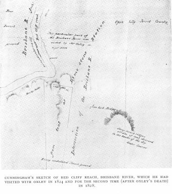
29. RED CLIFF REACH BRISBANE RIVER
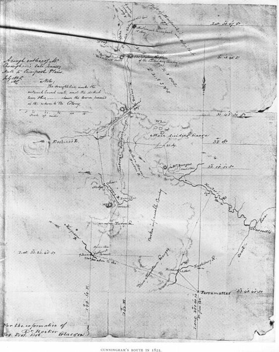
30. CUNNINGHAM'S ROUTE IN 1825
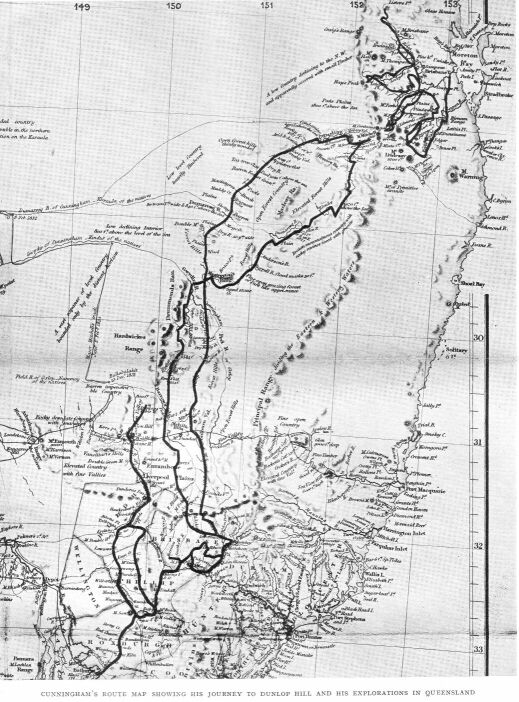
31. CUNNINGHAM'S ROUTE MAP OF 1827
32. CUNNINGHAM's ROUTE FROM SEGENHOE TO THE DARLING
DOWNS, SHOWN UPON A MODERN MAP
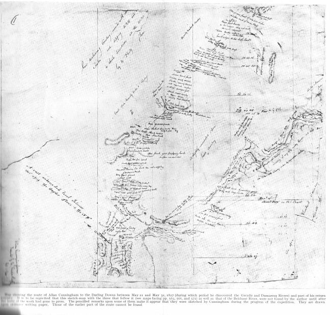
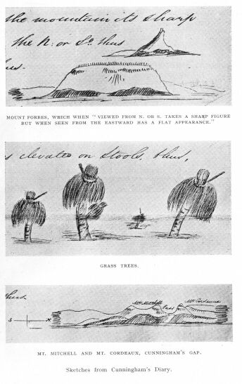
33. SKETCHES FROM CUNNINGHAM'S DIARY
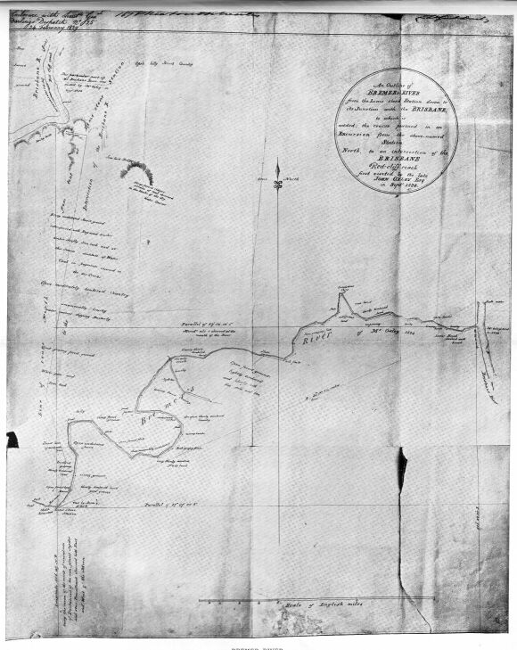
34. BREMER RIVER
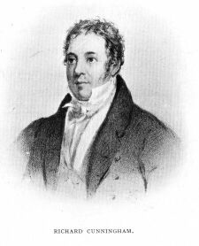
35. RICHARD CUNNINGHAM
From the earliest dawn of Australia's history the beautiful flora and singular fauna of the country have appealed to discoverers and naturalists. Yet the old Dutch voyagers who first came to the Great South Land collected few specimens of what they found there, and apparently no record exists of any of the country's natural productions having reached Europe until long after the names of Eendracht Land, Dedel's Land, and the Land of the Leeuwin were engraved upon the maps of the world.[*]
[* Heeres says: In 1605 Jansz surveyed the cast coast of the Gulf of Carpentaria as far as about 13°45'S. In the year 1616 the Dutch ship 'Eendracht,' commanded by Dirk Hartog, on her voyage from the Cape of Good Hope to Batavia...for the first time surveyed part of the west coast of Australia. As early as 1619 this coast was known by the name of Eendracht Land, and Dedel's Land (called after a sea captain named Jacob Dedel) was made in July, 1619, and appeared in the charts of 1627." The same writer observes: "Dedel's Land is bounded by the Land of the Leeuwin, surveyed in 1622. (See "Part Borne by the Dutch in the Discovery of Australia."--J. E. Heeres.)]
According to Labillardière, the first specimens of any kind to reach Holland from New Holland were two shells which had been given to Burgomaster Witsen of Amsterdam in 1698 by a sea captain in the service of the Dutch East India Company. This was William Vlamingh, who had visited Western Australia in the previous year; and, in a letter to Dr. Lister of the Royal Society Witsen says "he found them on the seaside, and I make bold to send you the draught of them, the shells themselves being twice as long and as broad as the draught." He adds the courteous message "I could not bestow them better than on one who hath the best knowledge of these and all other sea products." A description of the shells, with illustrations, was afterwards published in Lister's "Synopsis Conchyliorum "--one being the first nautilus,[*] the other then named the Concha persica clavicula radiata.
[* Nautilus pompilius.]
The Burgomaster's letter mentions other curiosities seen by Vlamingh in the new land, among them black swans, three of which were caught and taken to Batavia, but shortly afterwards died there; and on an island near the coast were "rats as great as cats which had a kind of bag or purse hanging from the throat downwards." On this account the Dutch gave the name of Rottennest[*] to the island and called the river where the swans were taken the Swan River.
[* Rats' Nest. The rats were a species of kangaroo rat.]
There were found also "many well-scented trees, and out of the wood is to be drawn oil smelling as the rose." A small bottle of it was distilled at Batavia and sent to the Directors of the Dutch East India Company at Amsterdam, which appear to prove that the eucalyptus first yielded its oil to the Dutch.
Soon after Witsen's letter had reached Dr. Lister, William Dampier brought home his collection of dried plants, including many gathered in Western Australia. Dampier had twice visited that country: he was there before Vlamingh, on his voyage with the buccaneers in the ship "Cygnet" of London under Captain Read, entering on January 5, 1688 what is now called Cygnet Bay, and he was there in 1699 in the "Roebuck," of which vessel he was in command;[*] and after Dampier's return from this voyage in 1702 more than ever before was known in England concerning the South Land.
[* After leaving Australia on his first voyage Dampier quarrelled with Captain Read and quitted the "Cygnet" at Nicobar. He made his way to Sumatra and reached England in 1691. Having been brought under the notice of King William III by the Earl of Pembroke, he was placed in command of Roebuck," an Admiralty ship, and sent on a second voyage of discovery.]
In the journal of his first voyage Dampier mentions New Holland several times before he is able to record that he has seen it. First of all, at the Ladrones he had been told by experienced seamen that ships bound to Java from the Cape of Good Hope often found themselves, and sometimes to their cost, on the shoals off New Holland; ships had been known to run aground there when their navigators thought that they were a great way from it, as to which Dampier remarks: "Hence possibly the Dutch call that part of the coast the Land of Indraught, as if it magnetically drew ships to it." In this, however, Dampier assigns a meaning of his own to the word Eendracht, which the Dutch had bestowed upon a part of Western Australia; for we know that the land was named in honour of the ship "Eendracht," the word itself meaning, in Dutch, "union" or "concord."
He mentions New Holland again after the ship had passed Timor, and, being uncertain as to what was the form or shape of the country he was about to land in, he describes it as "a part of Terra Australis Incognita." When he reached a shoal off the coast, he complained that it was laid down too far to the north-ward in the Dutch charts, and after the "Cygnet" rounded what is now known as Cape Lévêque and anchored a league to the eastward of its shores, on January 5, 1688, he gave this account of the country:
"New Holland is a very large tract of land. It is not yet determined whether it is an island or a continent, but I am certain that it joins neither to Asia, Africa, nor America."
Dampier wrote boldly; for, although early in the seventeenth century the Dutch had made discoveries on the north and west coasts, in 1606 Torres had sailed through the strait now known by his name, in 1627 Peter Nuyts had crossed the Australian Bight to Nuyts' Archipelago off the south coast, and in 1642 Tasman had discovered the shores of both Tasmania and New Zealand, yet nothing was known of the eastern or south-eastern coasts, and a multitude of geographers still believed the old fables that Australia was included within the boundaries of the vast Terra Australis Incognita, the imaginary Antarctic continent supposed to cover the whole of the southern portion of both the eastern and western hemispheres--an idea founded on the ancient theory that a southern continent was needed to maintain the equilibrium of the globe.
In the western hemisphere the southern continent was believed to join Tierra del Fuego or Magellanica (South America), and in the eastern hemisphere it was thought to stretch as far north as New Guinea, while its southern boundary ran as far south as the Pole itself. So firmly was this idea fixed in the minds of the most learned men that it had become difficult to eradicate it, and we find this imaginary continent portrayed in maps of the world up to the time of Dampier's coming to Australia.[*]
[* P. du Val, in his World Map of 1674, in order to show the Dutch discoveries in Australia, makes a sharp break in the outline of the imaginary continent, but he still keeps New Zealand as one of its promontories--part of a territory whose coast-line ran southward till it almost reached the southern extremity of South America; and Tasmania was thought to be another part of it.]
Points of this vast land had been identified and named by European seamen and others, the most familiar names given tc the various parts being Beach or Locach and Maletur--names handed down since the time of Marco Polo--Terra di Vista, Brasiliae Regio, Psittacorum Regio, or the Land of Parrots, in the eastern, and, contiguous to Tierra del Fuego Regio Patalis and Regio Magellanica in the western hemisphere.
By far the oldest portion of the Terra Australis was the land of Beach or Cape Beach. It was the title given to a tract of country in Northern Australia in the neighbourhood of Arnhem Land, while the old name Regio Patalis (the region of Patala at the mouth of the Indus) was bestowed at different periods upon various parts of the vast continent; Terra di Vista was another ancient name for land in 42° S. lat., of which nothing was known except that "it was 450 leagues from the Cape of Good Hope." Buache, the French geographer, is best remembered for the memoir he published in 1763 (only five years before Cook sailed on his first voyage), in which he enumerates the names appearing on the maps of Terra Australis, or, as he calls it, Terra Antarctica. In writing of Terra di Vista, Buache points out that "on Mercator's Great Chart published in 1569 (and on Wytfliet's Of 1597) there is also marked in these latitudes the great Gulf of St. Sebastian[*] and an island called Cressalina," "of which," he adds, "there is a MS. map in the collection of the Marshal d'Estrèes"...Buache's memoir was regarded as an important work at the time of its publication, so much so that afterwards it was reprinted by Alexander Dalrymple, hydrographer at the Admiralty, who possessed a wonderful knowledge of old and rare charts, and who collected valuable information respecting the tracks of vessels which were the first to sail among the islands and shoals of the Pacific and especially among those around the Australian
[* Not to be confused with the channel of that name in Tierra del Fuego.]
To return to the Gulf of St. Sebastian. Although Buache did not himself give its position as being near or off Australia, he believed that it was not far from Terra di Vista. Now, how-ever, it is thought that in all probability what he referred to as Terra di Vista was a portion of Western Australia, since it was placed to the south of the Cape of Good Hope and no land exists in the position assigned to it upon the maps themselves.
Cook was aware of the importance attached by geographers to the rediscovery of the Gulf of St. Sebastian, and as the Dutch formerly had given orders to their seamen to look for Cape Beach, so in like manner Cook was instructed to search for this gulf. The "Resolution" and the "Adventure" both looked for it, and we even find Dr. Solander, on his return to England in 1774, mentioning it in a letter to a friend when thus describing Furneaux's homeward voyage:[*] "He [Furneaux] sailed directly south from New Zealand till he came into lat. 55° and between that and 60° continued his course eastward...looking for St. Sebastian's Land and for Cape Circumcision, but arrived the 18th March last at the Cape of Good Hope without having seen an inch of new land...He has proved that there is no southern continent and that the French discoveries are small islands instead of continents; or perhaps, as my friend Omai calls ice, 'things that the sun drives away or causes to vanish.'"
[* Solander to Ellis, "Correspondence of Linnaeus," Vol. II, p. 17.]
On hearing that Cook did not find the Gulf of St. Sebastian, Dalrymple remarked that he should have looked for it in the eastern and not in the western hemisphere;[*] and possibly Dalrymple, although his theory regarding the existence of a huge southern continent was disproved, possessed evidence relating to the discovery of the gulf which has not been handed down to us. The remark at least raises a question as to where Dalrymple expected that Cook would find this gulf. We only know that upon some ancient maps, as for example on Wytfliet's of the continent of Terra Australis, 1597 (Map 1), there appears on its southern shores a wide opening (not unlike the real Spencer Gulf of early Australian maps) which bears the name of Golfo S. Sebastiano, and to the eastward of this is another river-like opening in front of which is an island called Cressalina. If we follow the coast-line of the continent round to the westward we come to another part of it named Psittacorum Regio, and this, in the opinion of competent authorities, was in fact Western Australia. Opposite Psittacorum Regio, or the Land of Parrots, and at a short distance from it, looms the Cape of Good Hope, but, judging from the position of Java Major to the northward and the Pacific Ocean to the eastward, the outlines of the Cape are even more out of their proper place on the map than are those of Western Australia.
[* Many believed that the gulf would be found in the western hemisphere, and Thomas Kitchin, the well-known geographer, in banishing the imaginary Terra Australis from his maps after Cook's return from his researches still retained a small portion of the land bearing the name of the Gulf of St. Sebastian, which he places to the south-east of the Falkland Islands--a little to the westward of where Ortelius had placed it on his map in 1587.]
In spite of the fact, too, that in this map the Gulf of St. Sebastian seems to have its origin a few miles from the South Pole, or that portions of Terra Australis are laid down within the limits of the Antarctic Circle, and that to the south-eastward the land shows no sign of ending, it seems to convey the impression of being an authentic discovery of Australia. Its eastern shores are bounded by the Pacific; New Guinea is shown as an island, and Beach on the north part is face to face with the island of Java Major. The text which was published with it gives this description: "The Australis Terra is the most southern of all lands. It is separated from New Guinea by a narrow strait. Its shores are little known, since after one voyage and another that route has been deserted and seldom is the country visited unless when sailors are driven there by storms. The Australis Terra begins 2 or 3 degrees from the Equator and is maintained...to be of so great an extent that if it were thoroughly explored it would be regarded as a fifth part of the world."
No great land south of the Equator excepting Australia answers to this description of Terra Australis, and, as Dalrymple believed the Gulf of St. Sebastian would be found in the eastern hemisphere, it would seem that he must have regarded the land on whose southern shores its name is inscribed, not as the huge imaginary continent supposed to spread over the southern portions of both hemispheres and to encircle the South Pole, but as a smaller continent confined within the limits of the eastern hemisphere, which could have been no other land than Australia.
It is probable that Europeans visited this continent even before the Dutch discovered portions of it. Witness the Portu-guese word "Abrolhos" on early sea charts, the name Terra del Zur on many old maps, and the rock carvings, found by Sir George Grey in Western Australia, one figure among them being garbed as a priest. These carvings apparently were the work of shipwrecked people who took up their abode in caves. The countenance of one man engraved in the rock shows that they were Europeans: they do not appear to be connected with any Dutch visit, and it is thought that they were survivors either of a French or a Portuguese ship, long since lost on these shores, of which no traces have been found. There is the story too, that Spanish ringbolts have been discovered in Sydney Harbour, which, if really true, would prove that this side of the continent also was visited. While controversy usually attends the finding of any signs of the presence of Europeans on the mainland at an early date, the knowledge that more than one old map showing Terra Australis bear dates prior to the arrival of the Dutch is sufficient to justify the belief that Australia was discovered before the beginning of the seventeenth century.[*]
[* The wooden globe of Paris, one of the most famous geographical records extant, made about the year 1535, bears an outline of a continent in the far south, having inscribed upon it the legend: "Terra Australis recenter inventa, Anno 1499. Another inscription of a similar nature appears upon the map of Oroncé Finé (1531), only omitting the date of discovery. In a work by Francis Monarchus entitled "De Orbis Situ," a small map bears a similar notice, and in the text of the book the date of discovery is set down as 1526. Vopellio's map, 1556, adheres to 1499 as the correct date. From this time forward cosmographers of different periods seem to have had no doubts concerning the authentic discovery of the South Land, although they could not agree in their methods of delineating its outline.]
Other geographers award the honour of discovery to the Malays, who came to fish for trepang on the north and north-west coasts. Both Flinders and King when surveying those shores met with their proas, and it is said that they had fished there for centuries. And probably if one race of mankind outside its native inhabitants can claim to have had the earliest knowledge of Northern Australia, that race would be the Malays. They are said originally to have inhabited Palembang and the banks of the River Malayu in Sumatra and to have migrated thence about the end of the twelfth century to the south-east extremity of the opposite peninsula, where they built the ancient town of Singapore and afterwards that of Malacca (though the name Malaya was applied to the peninsula many ages before). Some of the Malays, especially the traders of Celebes, lost sight of their coasts and pushed out on the open seas, directing their course by the position of the stars and sometimes by the aid of a compass. (At what time they came into possession of this seaman's guide is conjectural, although it was thought to have been introduced from China.) A voyage as far southward as Melville Island or Admiralty Gulf would have been quite an easy matter for their fleets.
But turning from the mists of tradition to the clear light of written history, the fact that the Portuguese and Spanish first made charts of Australia carly in the sixteenth century would show that at that time they must have gained some definite knowledge of its coast-line. So jealously, however, did these two nations guard the secrets of their voyages and charts that no records of their discoveries have been handed down to us. It may be significant in this connexion that Wytfliet's map was dedicated to the King of Spain.
At the end of the sixteenth century a new maritime power sprang into being. Holland, having successfully waged her war of independence against Spain and wrested from Portugal her supremacy in the eastern seas, China as well as India and the Spice Islands became the scene of Dutch activity, and Dutch ships began to take the leading part in the maritime exploration of Southern Asia. These ships when bound for Bantam (the western portion of Java) must have sighted Australia, especially when stormy weather drove them to its shores. Their first knowledge of the southern continent is believed to have been acquired in 1595 in a voyage fitted out by some rich Dutch merchants, at the instigation of Cornelius Houtman, a merchant who had lived in Lisbon and had gathered from the Portuguese particulars concerning their discoveries. Being imprisoned for debt there, Houtman wrote home to the Dutch merchants, giving them much information regarding the East, and they obtained his release and sent him upon this voyage to the East Indies. On the way from Antongil (on the east side of Madagascar) to Java the compasses of the Dutch ships were subject to great variation, and by going too far north they failed to make certain sandbanks (probably the Abrolhos or those near Point Cloates) "marked on their Portuguese charts" which they should have sighted, and Wytfliet says that on this voyage much was learned of the Australis Terra. For fully sixty years the southern continent now became the goal of the Dutch navigators, and Dutch expeditions left Holland in quick succession with instruc-tions to investigate and report upon the South Land, to which they gave the name of New Holland. The stories of these voyages have their places in the Dutch archives and are well known to us. Of late years the records have been published and contain all that is known concerning the Dutch discoveries in New Holland.
About the year 1600, after the founding of the East India Company, we find English ships beginning to compete with the Dutch for a portion of their trade with the East. With the eastern monsoon the English sailed eastward principally by what the Dutch called their "new route," that is to say, round the Cape of Good Hope past the islands of St. Paul and Amsterdam, thence making the coast of New Holland.[*] Between New Holland and the south-eastern shores of Asia the Indian Ocean flows through many channels into the Pacific, and ships coming from the southward across the Equator to China and japan had to pass through some of these channels. "It soon became a recognized practice for British seamen destined for the straits between Java and Timor to secure the land-fall from New Holland."[**] Instead of coming there by accident or through being blown out of their course, we learn that now the ships made it "their principal care to fall in with New Holland."
[* Early Dutch navigators recommended seamen to make the South Land in 26° Or 27°. British ships usually made it in 22° or 23° S.]
[** "A New Directory for the East Indies," S. Dunn. 5th ed. London, 1780. P. 368.]
The earliest accounts in their captains' log-books and journals telling of how they first saw what is now a British possession are full of interest to-day and should have a place in every Australian history. There are not many records relating to these English voyages. Here and there a log-book of ancient date states the bare fact that the land was sighted, or an old directory quotes the remarks made by some captain--small scraps of intelligence, yet sufficient to prove that long before Cook discovered the east coast in the "Endeavour" British seamen had reached and taken their bearings from the west coast of New Holland.
One experienced commander[*] (the date of whose voyage is not stated), after giving 22° 31' S. as the latitude that ships should endeavour to make for, sounds a note of warning with regard to the perils around its shores. "I must observe," he writes, "that till under the lat. of 26° S. the coast of New Holland must be approached with caution as there is great danger, though there are many never-failing guides to warn you of your approach, such as great quantities of skuttle-bones, weeds and drifts, and near the Bank grampuses playing like seals and innumerable quantities of Tropick birds, but skuttle-fish and weeds are commonly the first marks. The land in lat. 22° S. and 23° S. is low, the soundings 130 fathoms mud about 14 leagues from the coast."
[* Remarks published by William Nichelson of H.M.S. "Elizabeth," 1758-64.]
One can picture, while the east coast remained all unknown the little stream of British ships making its way eastward to Western Australia, creeping along the reefs in the darkness past the low sandhills and grassy slopes in the neighbourhood of Point Cloates and North-West Cape, where now, from lighthouses of grey concrete, every five or seven seconds a flashing white light is thrown upon the seaman's path. The little stream of ships with the advancement of time has grown into a big river with many branches, which divide and penetrate every harbour of the continent.
The first English ship to reach Australian waters of whose coming a record survives was the ship "Trial"[*] She was wrecked in 1622 upon rocks which soon were placed on charts under the name of the Tryal Rocks, although for long they were thought to be of doubtful existence. Ten of the ship's passengers safely reached Batavia on July 5th; a second boat came there on the 8th with thirty-six survivors, and these informed the Dutch Governor (Koen) that they had abandoned their ship with ninety-seven people on board in lat. 20°10' S. They also stated that the "Tryal" had struck upon the reef during the night in fair weather. Both English and Dutch ships looked for the rocks, yet gradually people doubted their existence, because seamen who claimed to have sighted them placed them in entirely different latitudes. Dampier hoped to find them. The "Jane" frigate in 1705 searched for them in vain, although her com-mander guessed the truth concerning their situation. In his journal he wrote on June 27th of that year: "Hove to, according to custom, on account of the Tryal Rocks (if such exist), for although they are reported to extend 20 leagues in length I was informed by the Commodore of the Dutch ships ... that he never heard of these rocks being seen. If they exist they must lie much farther east than in the route toward Java Head."
[* The "Tryal" carried a letter from the Hague to Dutch authorities in the East giving particulars of the Treaty concluded in 1619 between the English and Dutch E.I. Companies.]
Many years after a Dutch sloop was again sent to explore them in consequence of their having been seen by the ship "Vaderland Getrouw" in 1718 in 20½° S. The sloop sighted and charted them and reported that they ranged from east to west forty miles, were in lat. 19°30' S. and were eighty leagues from New Holland. Captain Foss of the Danish ship "Fredensberg Castle" saw them in 1777, and geographers continued to place them on their maps, yet many sailors still refused to believe that they existed. At last the voyage of the ship "Greyhound," on her passage from China to Port Jackson as late as 1819, reopened the question by her commander declaring that he had met with a reef of rocks in lat. 19°59' S., long. 103°30' E., which were the long-lost Tryal Rocks.
In 1820, after a minute survey of the different situations where these rocks had been reported, Lieutenant Phillip Parker King in H.M.S. "Mermaid" came to the conclusion that the Monte Bello Islands exactly answered the description given by the Danish captain, and he states, "There remains no doubt in my mind but that Barrow Island (in 20°40' S., 115°27' E.) and Trimouille Island (of the French) and the numerous reefs around them are the identical Tryal Rocks." Since King's day naval surveyors have found the exact position of the rocks. "Admiralty Sailing Directions" (1917) state that "Tryal Rocks, awash at high water, are near the outer edge of the S.W. part of Monte Bello Islands reef and 5 miles N. of the north extreme of Barrow Island." King attributed the difficulty of identification to errors in longitude on the part of early navigators whose reckonings, as is well known, cannot be relied upon, owing to the fact that they had to depend upon their chronometers, which were liable to get out of order.
The second English ship to make the Australian coast of whose presence off the Abrolhos a record has been preserved was the "London" under Captain Daniel, who came there in June, 1681, according to Thornton, Horsburgh and Thomson (Dalrymple places the date as 1687), and therefore Daniel saw these shores before his countryman Dampier. Of his coming Captain Daniel wrote in his journal: "With the wind S.W. by W. steering by compass N.E. by E, at 10 a.m. the water was discoloured: a man at the foretop saw a breach rise ahead of us. We put our helm hard a starboard and stood away N.W. by W. and weathered the N.W. end of it about ½ a mile: at that distance the depth was 35 fms. white corally ground with some red mixed: next depth (about 2 hours after we tacked) was about 40 fms., the same ground, and at 9 p.m.having run off by log on a N.W. by W. course had no ground at 65 fms...The breach which we first saw happened to be the northernmost of all, there being several and by our computation are 20 miles in length. Within the breaches several small white sandy islands were seen with some bushes on them: a very heavy sea broke against the south part of these. When close to them the mainland was not seen."
Captain Daniel apparently saw Wallabi Group, the northern-most of the three groups of islands and rocks comprising the Abrolhos. He named it "Dangerous Rocks," He also may have given the name of Maiden's Isle to Rottnest Island, as it is so called in many old atlases. He made a chart of the Abrolhos which was published by Dalrymple, and, however imperfectly it may represent these shoals, it seems to have been the first attempt by an Englishman to chart the shores of Australia.
There is a curious silence among historians regarding Cloates Island, or Cloates Doubtful Island, off Western Australia, yet to sailors in olden days it was an island of mystery; and for English sea captains who made it their duty to fall in with New Holland it possessed a peculiar attraction. They looked for it and wrote about it in their log-books more than any other part of the continent, because for years people were wont to disbelieve in its existence too. Owing to the hidden trendings in the coast and the elbow that is formed in its outline where they first sighted land a difficult problem was presented to one sailor after another which none could solve.
Lieutenant King also found that Cloates Island did exist and was not an island or shoals like the Tryal Rocks and the Abrolhos, but actually formed a part of the mainland. Early explorers had passed along this portion of the coast, though none had named the point until in 1719 it was suddenly christened Cloates Island, and Cloates Island it remained until a hundred years later, when King proved it to be a peninsula. This supposed island was discovered by Captain Nash (possibly an Englishman), in com-mand of a Flemish ship, the "House of Austria," bound from Ostend to China. On seeing it he wrote in his journal: "Being clear weather brought to, sounded, and had no ground with 100 fms. though not above four miles off shore. The day before and several days after observed an incredible quantity of seaweed like that from the Gulf of Florida and small birds like lapwings both in size and flight. This island cannot be seen far even in clear weather and lies N.E. by E. and S.W. by S. about 32 leagues in length with terrible breakers from each end running about three miles into the sea." He gave the lat. as 22° S. and from it made 7°26' westing to Java Head. As he could find no account of this land in any of his books or charts Captain Nash named it Cloates or Cloot's Island in honour of a Flemish Baron, one of the owners of the ship.[*]
[* "A New Directory for the East Indies," S. Dunn. 5th ed. 1780.]
Other ships followed Captain Nash's route and saw Cloates Island, and reported having seen it. Captain Pelly of the ship "Prince of Wales" in 1739 at first sight thought the land like small islands, so very low that they could not be seen from the deck. A great smoke was rising only at five or six leagues distant. He "sounded and had no ground at 160 fms...raised the land and found it long and level about the height of the Lizard."...He believed "the land like islands joined to the rest." The last sentence seems to show that Pelly queried the report that the land was a single island, or else had seen other islands in the north-east.
Another East India Company's ship, the "Haeslingfield," sighted Cloates Island in 1743. On July 16th Captain Robert Haldane[*] records having seen weeds and common berries in the water in lat. 24°33' S.; "also next day but not so much as before." On the following day, Monday, July 18th, he writes: "Saw Cloot's Island. Lay to...Made sail...Kept a good look out all night, having been yesterday at noon only 75' to ye southward of Cloot's Island discovered by ye 'House of Austria,' an Ostend shipping, by our account not a great way from ye meridian in which they made it. At daylight saw it bearing S.E. ½ S. to E. by S. distant 6 leagues. Sounded, but had no ground with fms., nor have we seen any scuttle bones at all nor weeds since the 16th and 17th as they mention, and but 2 or 3 birds of a whitish colour and of size of a pigeon. It extends from N.N.E. to S. by W. about 9 or 10 leagues in length and rises gradually towards the middle; from the N.E. end of it runs a ledge of rocks upon which we saw breakers a great way out. By a very good observation I make it to lie in lat. 22°08' S. and 32°01' East from St. Paul's, which agrees pretty well with a journall of ye above mentioned ship by accident found on board.[**]...I am apt to believe that this island is laid down...in charts a good deal too much to westward." The last remark was true. "Doubtful" Island has always been placed too much to westward, and at some distance from the mainland.[***]
[* India Office Log-Book.]
[**] The curious fact of Captain Nash's journal being found on board the "Haeslingfield" is additional evidence that he was of English nationality.[***] Upon the charts showing Cook's first discoveries, and upon the atlas pub-lished with La Pérouse's voyage, it is shown between the erroneously charted Tryal Rocks and the Australian coast. On the map drawn by Lieutenant Roberts, R.N., to describe Cook's track in his last voyage, Cloates Island appears twice, to the south-east and again to the south-west of the Tryal Rocks and beneath the latter island is given the further information "according to the French." In Purdy's "General Chart of the World," 2nd ed., 1812, it is shown with the addition of "doubtful," and also (without that qualification) in Espinosa's Spanish Chart of the same date. Cloates Island must not be confused with Kalatoa, or Old Clouts Island (upon which the "Ocean" was wrecked) in the Flores Sea.]
Fifty-three years after the "Haeslingfield" had passed (in the year 1796) the master of the ship "Belvedere" reported having seen Cloates Island "on the lee bow bearing E. by N. 5 or 6 miles at 9; breakers off each end...10 a.m. a bluff point seen from the masthead." After steering ten miles, the observed lat., being 21°10' S.[*] "the body of Cloat's Island was seen half way up the mizen shrouds."
[*] Its true lat. 22°42' S., long. 113°'41' E.
But by this time geographers were inclined to be sceptical, and Horsburgh writes: "This evidently was not Cloates Island but some of the low islands in the bight to the east of North-West Cape." Joining the unbelievers, he adds: "Cloates Island very probably has no real existence."
Lieutenant King, however, who was sent by the Admiralty to explore the north-west coast, was not the man to pass over any reliable evidence concerning early discoveries in those regions and he determined to examine this coast. He came there first in 1818, and on February 10th saw the land and described its outer shore very much after the manner of early seamen: "The coast is tolerably elevated, may be seen at a distance of 6 or 7 leagues. The shore is fronted with rocks that extend 3 or 4 miles into the sea, on the extremity of which the surf breaks with a continued foam." On the 14th he rounded North-West Cape and entered the bight which he named Exmouth Gulf, and before dark his ship, the "Mermaid," had sailed twenty-five miles down the opening without seeing its termination. Exmouth Gulf is twenty-seven miles wide between Tubridgi Point and North-West Cape, and has been traced fifty miles into the land yet even to-day a great part of it is very imperfectly known. "The western side trended southwards, losing itself in distance and bore the appearance of being an island," King records after bringing the "Mermaid" to an anchorage in an inlet called Bay of Rest, or Jogodor. From here he continued his examination, but was forced to leave Exmouth Gulf without being positively certain whether the bay within it in which his ship had anchored was a part of an island or of the continent.[*]
[* Allan Cunningham, the botanist on board, had little doubt that it formed part of the mainland. (See his journal, February 16, 1818.)]
In October, 1820, during his third voyage to the north-west coast, King wrote: "The existence of Cloates Island, of which there are so many undeniable descriptions, was for a long time questioned by navigators. I think, however, that it does exist, and that it is no other than the mainland to the southward of North-West Cape." When he came to the curious arm or elbow in the coast-line which had caused sailors to mistake this peninsula for an island, he observed: "In the neighbourhood of the Bay of Rest (within the Gulf) the shore is more sinuous...here the Gulf is twelve miles across...the Gulf then shoalens and at fifteen miles farther terminates in an inlet...at the south end of the high land that forms the west side of the Gulf and which is doubtless the identical Cloates Island that has puzzled navigators for the last eighty years.[*] It perfectly answers the descriptions that have been given, and the only thing against it is the longitude, but this like that of the Tryal Rocks is not to be attended to."
[* King's "Intertropical Australia," Vol. 11, P. 365.]
It is evident that King was keenly interested in the history of Cloates Island and was determined to remove all doubts as to its identity. And after he had examined it he says: "The description of this island by Captain Nash of the ship 'House of Austria,' as well as that of the 'Haeslingfield' in 1743 and by Captain Pelly, accord exactly with the appearance of this promontory, nor is the longitude much in error when we consider the strength of the currents which set to the north-west during the easterly monsoon in the space between New Holland and Java."[*]
[* King's "Intertropical Australia," vol. 1, P. 443.]
Thus once and for all King cleared up the mystery which had for so long surrounded Cloates Island.
From these glimpses into the log-books of British seamen who sighted the west coast, we pass to the journal of William Dampier, the first Englishman of whose landing we have actual record.
On the "Cygnet's" arrival off Cape Lévêque, Dampier recorded his first impressions of the country. "This part," he writes, "is all a low, even land with sandy banks against the sea...the points rocky and so are some of the islands in the bay...The soil is dry and sandy, destitute of water, except you make wells, yet producing divers sort of trees." He at once noticed a species of eucalyptus which grew most abundantly, calling them dragon trees, and describing them as "the largest of any there. They are about the bigness of our large apple trees...the rind is blackish...The leaves are of a dark colour. The gum distils out of the knots or cracks that are in the bodies of the trees. We compared it with some Gum-dragon or Dragon's Blood that was aboard and it was of the same."
On January 5, 1688, after the "Cygnet" had anchored, some natives were seen walking on the shore. A boat was sent off from the ship in the hope of being able to get water and provisions, but on seeing it approaching them the blacks quickly disappeared. For three days the buccaneers searched for their houses, but found none; then, anxious to be on friendly terms with the inhabitants, left toys in different places which it was thought they would visit. A little later, while searching for water among the islands, Dampier and his shipmates came upon a great many natives.
He describes these people as being "tall and thin, with long limbs...great heads, round foreheads, and great brows. Their eyelids always half closed to keep the flies out of their eyes, they were being so troublesome, no fanning will keep them from coming to one's face. They have great bottle noses, full lips, and wide mouths, and the two fore teeth of the upper jaw are wanting in all of them." He thought the colour of their skin was coal black and that "they have no sort of clothes. They have no houses but lie in the open air. Earth being their bed and Heaven their canopy." On looking around to see what they lived upon, he says: "Their only food is a small sort of fish which they get by making wares of stone across little coves,"[*] and adds: "Their chiefest dependence is what the sea leaves in their wares...be it night or day, rain or shine, they must attend to them or else they must fast, for the earth affords them no food at all." Some of them "had wooden swords; others a sort of lance; the sword is a piece of wood shaped somewhat like a cutlass." From which it appears that they carried boomerangs, of which Dampier has left us this impression. He imagined that the natives used stone hatchets as he saw no iron or other metal, and believed that they obtained their fire "by rubbing or twirling a hard piece of wood between the palms of their hands" against a softer piece "until it smokes and at last takes fire."
[* These stone weirs were afterwards seen by King on the north-west coast in 1818, by Roe at Oyster Harbour, West Australia, and by Oxley on the Lachlan River, New South Wales; and King remarks that by their being found on the south-east, south-west,and north-west coasts, he concluded "this expedient was a native practice throughout the continent."]
On one island (to the eastward of Cape Lévêque) the buccaneers discovered about forty inhabitants--men, women, and children--who, on seeing white men landing there were at first "much disordered" and "made a great noise," but when they saw no harm was intended they became more subdued. For a dwelling-place they possessed "only a fire with a few boughs before it--set up on the side the wind was." When they grew friendly the sailors tried to make them help to water the ship. They put clothes on some of them and led them to the wells (where water had been found) and placed a barrel of water on each man's shoulders to be taken to the boat, which was only waste of time, for the natives "stood like statues and grinned like so many monkeys"; and Dampier relates, "We were forced to carry the water ourselves but they very fairly put the clothes off and laid them down," no doubt highly pleased to be rid of them.
While one of the boats was seeking food in these islands (to which the name of Buccaneers' Archipelago has since been given) a number of natives were seen swimming from one island to another, and consequently it was believed that they had "no boats, canoes, or bark logs." The way in which these tribes propelled themselves through the water is described, however, by Allan Cunningham in a later chapter of this volume. Four natives were brought on board the "Cygnet," when they greedily devoured rice boiled with turtle and dugong which the English set before them.
On one occasion some of the blacks who lived on the mainland came close to the ship, and standing on a high bank began to threaten the sailors by calling to them from their high position and wildly flourishing their spears and boomerangs; nor would t leave off until Captain Read ordered the drum to be beaten. Then they hastily took their departure, "crying 'Gurry, Gurry' deep in the throat." At spring tide the "Cygnet" was hauled into a small sandy cove as far as she could float. When the tide turned, the dry sand extended around the ship for nearly half a mile, and in his diary Dampier says: "All the neap tides we lay wholly aground for the sea did not come within 100 yards of where she lay"; which gave the men time to clean the bottom of the ship. Meanwhile, most of the sailors lived ashore in a tent and mended their sails, their constant food being manatee (dugong)[*] and turtle. On March 12th the "Cygnet" left the shores of New Holland, directing her course to the northward.
[* A full-sized dugong--popularly known as the sea-cow--ordinarily furnishes about a ton of good meat. Part of the flesh resembles beef and other portions would easily be mistaken for pork. Dugong feed on the seaweed growing in shallow waters round the coast.]
When he visited Australia for the second time as captain of the "Roebuck"--some eleven years afterwards--Dampier spent about three weeks on the west and north-west coasts discovering harbours, meeting natives, and sometimes landing upon its shores. It is said that he was "well acquainted with botany," and he thus describes the natural features of the coast at Shark Bay, which he entered on August 7, 1699, and anchored within it, at three different places: "The land is of indifferent height...There are many gentle risings neither steep nor high...but in this bay or sound...the land is low by the seaside, the mould is sand...producing a sort of sampier [samphire] which bears a white flower. Farther in, the mould is reddish...producing some grass, plants, and shrubs. The grass grows in great tufts as big as a bushel, here and there tufts being inter-mixed with heath...much of the kind...growing on our commons in England."
There were curious trees of different sorts, and the visitors thought the foliage of some even more curious; many grew to a height of five or six feet "before one comes to their branches, which are bushy"; the colour of their leaves was white on one side and green on the other. There was long grass growing there, but it was very thin. Some of the trees were sweet--scented and turned "reddish within the bark like Sassafras but redder...Most of these and the shrubs had either blossoms or berries on them. The blossoms...were of several colours as red, white, and yellow, but mostly blue, and these generally smelt very sweet and fragrant, as did also some of the rest; there were beside...plants, herbs and tall flowers and some very small flowers growing on the ground that were sweet and beautiful, for the most part unlike any I had seen elsewhere."
"Of large land fowl," Dampier saw "none but eagles, and five or six sorts of small birds...not bigger than larks, some no bigger than wrens, all singing with great variety of fine shrill notes," and the sailors caught sight of some of their young ones in their nests. There was an abundance of water-fowl in Shark Bay, among them duck--these also had young ones--gulls, and pelicans, and others of a kind never seen before. The land animals were "only a sort of raccoon...with very short fore legs," and he says they "go jumping" and were good meat, which would show that he met with a small species of kangaroo.
The lizards resembled other lizards excepting in three remarkable particulars: they had "a larger and uglier head and had no tail...instead...they had the stump of a tail which appeared like another head."[*] They were very slow in motion, and when "a man comes nigh them they will stand and hiss," and so hideous did they appear to him that he observes: "I did never see such ugly creatures anywhere." There were plenty of sea-fish and shell-fish: among the latter, oysters both of the pearl and the edible variety, and the shore was "lined thick with many sorts of very strange and beautiful shells, for variety of colour and shape most finely spotted with red, black, and yellow," such as he had not seen anywhere "but at this place," and he brought away what he could.
[* The stump-tailed lizard, Trachysaurus rugosus.]
There were a great many sharks in this bay, and these, he says, our men "eat very favourily." Inside a huge one that the sailors cut open was found part of a dugong. Being ignorant of the Malayan name of this herb-eating mammal, Dampier called it a "hippopotamus," and because the sharks were so numerous he named the indentation Shark Bay.
When his ship left there on August 14th he proceeded to follow the coast round to the north-east and passed through many islands of a pretty height, which, he thought, must stretch back "as far as to those of Shark Bay." He had a strong suspicion that these constituted an archipelago of islands.[*] and that possibly there was "a passage to the south of New Holland and New Guinea into the Great South Sea eastward."
[* The French Commander, L. de Freycinet called it Archipel de Dampier in 1803.]
He therefore determined to examine the islands, the largest of which were "mostly rocky and barren," the rocks being of a rusty yellow colour, and the "Roebuck" anchored on August 22nd on the inner side of an island the outside of which he describes as "a bluff point."[*] Here he landed with some of his men, who took shovels to dig for water, but none was found. He found that two or three sorts of shrubs grew there, "one just like rosemary and therefore I called this Rosemary Island." The rosemary shrub grew plentifully but "had no smell...Some other shrubs had blue and yellow flowers," and there were two sorts of grain like beans: "the one grew on bushes, the other on a sort of creeping vine that ran along the ground." Dampier says that this vine had thick, broad leaves, and the blossom resembled "a bean blossom but much larger and of a deep red colour looking very beautiful." It appears likely, although the description of the leaf is hardly a true one, that this last was Dampier's Glory Pea (Clianthus Dampieri, Cunn.), a specimen of which is contained in Dampier's Herbarium. His collection.[**] is still preserved at Oxford, and besides the Glory Pea there are in it the following plants that he brought from New Holland: Casuarina equisetifolia, Melalcuca gibbosa, Solanum orbiculatum, Tripolona Dampieri, Dammara alba, and Trachymene pusilla.
[* Writing of Dampier, Captain P. P. King says: "I take Malus Island to be that on which he landed and the bluff...is no other than our Courtenay Head." From the south-east "in the bearing Dampier saw it, Rosemary Island would appear to be joined to Malus Island, and hence his opinion that it was an island five or six leagues in length and one in breadth."]
[** Also called Sturt's Desert Pea. Drawings of seven plants seen by Dampier were engraved in Plukenet's "Almatheurn," 1769, while about eleven appear in the "History of Dampier's Voyage."]
Among the land birds the most noticeable were "white parrots, which flew a great many together," besides numberless sea-fowl. The "white parrots" were the slender-billed species of white cockatoo (Licmetis pastinator, Gould), now known as Dampier's Cockatoo. In August and September these birds still fly "a great many together" from the mainland over to Rosemary Island and the other islands of Dampier's Archipelago, where they breed in the holes of the rocks.
The anchorage at Rosemary Island proving unsatisfactory, and as he could find no water, Dampier stood away on August 23rd and steered to the north-east. In fine weather, with a clear sky, "there being not one cloud to be seen," the "Roebuck" coasted along the shores of the mainland, looking for an opening during the day but "edging away from it at night" for fear of shoals. At night when it was calm the sailors fished with hook and line and they then took many kinds of fish, including snapper, bream, and dog-fish, and also caught a monkfish, of which Dampier brought home a drawing. This appears in the story of his voyage.
On the 28th the "Roebuck" lost sight of the land and a great many water snakes now appeared in the water, and birds, chiefly boobies and noddies, hovered about the ship's track. At night a noddy was caught: the top of its head was coal black, the breast and under part of the wings white, and the back and upper parts faint black or smoke colour. It had feet just like a duck's feet and a deeply forked tail and very long wings.
On the 30th land was seen again and the ship anchored in the afternoon three and a half leagues off shore, coming into a bay which has since been named Roebuck Bay.[*] In the earlier part of the evening an eclipse of the moon was witnessed but not very clearly, for the horizon was hazy. The moon had been "half an hour above the horizon and at 2 hours 22 minutes after sunset the eclipse was quite gone."
[* The space between Cape and Point Gantheaume was named Roebuck Bay by Captain P. P. King, as "here Dampier had anchored in the 'Roebuck's voyage."]
Next day Dampier landed with a well-armed watering party, who "carried shovels and pickaxes to make wells. When they came near the shore they saw three tall, naked black men in a sandy bay who as the men rowed in disappeared." The boat, in charge of two seamen, was then sent off shore to wait while the rest of the party went in search of the natives, who at length were seen with eight or nine more standing on the top of a small hill a quarter of a mile away. On catching sight of the strangers coming their way they quickly dispersed. From this hill Dampier saw a low, open plain half a mile off with "several things like haycocks" dotted over it. He thought these objects were houses at first, but "found them to be so many rocks." He returned to the landing-place, where the men had begun to dig a well, when nine or ten natives made their appearance at a little distance away and began to threaten them. Dampier says, "At last one came towards us and...I went out to meet him making...signs of peace and friendship, but he ran away. I took two men in the afternoon along by the seaside purposely to catch one...of whom I might learn where they got their fresh water. There were 10 or 12 natives a little way off, who seeing us going away from the rest of our men followed us at a distance...There being a sand bank between us and them, we made a halt and hid ourselves in a bending of the sand bank. They...thought to seize us. So they dispersed themselves some going to the sea shore, and others beating about the sand hills...So a nimble young man that was with me...ran towards them...soon overtaking them, they faced about and fought him. He had a cutlass and they had wooden lances...being so many...they were too hard for him...I chased two more that were by the sea shore, but fearing how it might be with my young man I turned back quickly...to the top of a sand hill whenceIsaw him near me closely engaged with them. Upon seeing me one threw a lance at me that narrowly missed me.Idischarged my gun...but avoided shooting any of them till finding the young man in great danger...and myself in some, and that though the gun had a little frightened them at first they...soon learnt to despise it...crying 'pooh pooh pooh' and coming on afresh, I thought it high time to charge again and shoot one of them which I did. The rest seeing him fall made a stand again and my young man took the opportunity to disengage himself and come off to me. My other man also was with me...and I returned back with my men being very sorry for what had happened. They took up their wounded companion...and my young man who...had been struck through the cheek by one of their lances...was afraid it had been poisoned...but he soon recovered."
Among the New Hollanders there was one who by his appear-ance seemed the chief of them all and a kind of prince or captain among them. He was a young, brisk man, not very tall nor so "personable" as some of the others, but much more active and courageous, painted--as none of the rest were--with a circle of white paste or pigment about his eyes, a white streak down his nose from the forehead to the tip, and his breast and part of his arms white with the same paint, not for beauty or for ornament but to make himself look more terrible, his painting adding very much to his natural deformity. All these savages had "the same black skins and frizzled hair," the same blinking eyes, and had the same kind of flies teasing them as those seen by Dampier in his former voyage, when he came to the north-west coast and touched at a part which was "not above 40 or 50 leagues to the north-east of this."
Here too were many native fire-places with three or four boughs "stuck up to windward of them." Round these fire-places there were nearly always found heaps of shells, and consequently he surmised that these people lived on shell-fish, as did those met with in his first voyage. Their spears also were similar, but the natives seen in the "Cygnet's" voyage were on an island in the company of women and children, and it was imagined that for that reason they did not attempt to attack the white men, as these on the continent had done, where only men were congregated.
Although the watering party had dug down eight or nine feet they found no water, so on September 1st Dampier sent the boatswain of the "Roebuck" ashore to dig deeper. Next morning the men returned with "a rundlet of brackish water" which they had got at another place, but it was not fit to drink. However, he decided that "it would serve to boil oatmeal for burgoo, and the sailors subsequently brought aboard four hogs-heads of it." It was perceived that the tides ran very swiftly here, and at low water the shore was rocky; but at high water a boat could pass over the rocks.
No more was seen of the natives, though the smoke of their fires was observed two or three miles away. The land resembled the shores of Cygnet Bay. Dampier describes it as being "barri-caded with a chain of sandhills to the sea." The soil by the sea was dry and sandy, bearing shrubs and bushes. Some of these had "yellow flowers or blossoms, some blue and some white: most of them with a very fragrant smell. Some had fruit like peapods, in each of which there were just ten small peas...no more nor less." There were also here some of that sort of bean that Dampier had found at Rosemary Island and another "of red, hard pulse growing in cods also with little black eyes."[*]
[* Abrus precatorius.]
He says: "I know not their names but have seen them used in the East Indies for weighing gold and...at Guinea as I have heard the women make bracelets with them to wear about their arms. These grow on bushes; but here are also a fruit like beans growing on a creeping sort of shrublike vine."
The land farther in...was very plain and even, "partly savannah and partly woodland..." Here there were a great many rocks five or six feet high and "round at the top like a haycock," beyond them again, farther inland, small trees...twelve or fourteen feet high "with a head of small...boughs"; while by the sides of the creeks, and more especially near the sea, were a few small black mangroves. Dampier saw few animals, although his men described "two or three beasts like hungry wolves, lean like so many skeletons," which doubtless were dingoes, and some lizards were noticed as well as a "raccoon or two" and one small speckled snake. Among the birds there were crows or birds "closely resembling the English crow"; also plenty of turtle-doves" that were plump and fat and very good meat." A great many green turtle were seen, but none were caught, there being no place there to set a turtle net and no channel for them.
He here added to the collection of shells that he had gathered at Shark Bay, obtaining some that were strange to him, "chiefly a sort not large, and thick set all about with rays and spikes...in rows." But of his collection he afterwards "lost allexcept a few, and those not of the best." It is probable that some of these shells reached England as well as his herbarium although his ship sprung a leak on the homeward voyage and foundered at the Isle of Ascension in 1701.[*]
[* Ten weeks later three English men-of-war called there, and on board these ships Dampier and his men returned to England.]
After Dampier had finished writing the story of the "Roebuck's "voyage" he added some further particulars respecting the South Land which show us that he no longer believed in the existence of a great southern or Antarctic continent. He was satisfied that in his travels he had found a number of islands spread over the waters where the land of Terra Australis Incognita had been supposed to extend, and he observes, "'tis probably the same with New Holland."
On maps of the world the portions of New Holland discovered by the Dutch were now being methodically laid down and the vast imaginary continent left out. Gradually, in its true place in the eastern hemisphere, a vague outline of Australia appeared, but of so curious a shape (as for example in the world maps of Le Rouge and Robert Vaugondy) that it bore only a deformed likeness to the real island-continent. The east coast had never been seen, so an imaginary coast-line was given to it which, starting at the New Hebrides in the north, ran south-westerly without a break until it joined the southern extremity of Tasmania.
The day was now approaching when all doubt was to be dispelled and Australia was to take her place as a known continent.
In 1770 a little English ship, not at all majestic--like other British men-of-war--and bearing a name as humble and unpre-tentious as herself, discovered the east coast and gave to it its real form on the map of the world. A little bark[*] Of 370 tons, she flew the white ensign and bore herself steadily through heavy seas and stormy weather; yet it still seems wonderful that so small a ship should carry out a misson of which it has been said it was "to the English nation the most momentous voyage of discovery that has ever taken place."[**]
[* As the word was then written.]
[** Preface to Cook's Journal by Admiral Wharton. The Admiralty instruc-tions ordered Cook, who had received a lieutenant's commission, to proceed to Tahiti, and after the completion of the astronomical observations at that island, to continue the discoveries in the Pacific in which Byron and Wallis had been engaged. Tahiti had been recommended by Wallis, who had returned just before Cook sailed, as the point from which the transit of Venus should be observed.][
The seaman who commanded her was James Cook. Some-times we hear that Captain Cook has not been fully appreciated in his native land, but if this is so, at least let it be said that among his countrymen who travel farthest, more especially among those whose paths lie on the sea, there has been reserved for him within the great Empire of Britain a true measure of his worth. In the lands visited by him in the South Pacific his name and his doings live as those of no other navigator of any age or race. We will endeavour to re-state briefly how he discovered the east coast.[
Lieutenant james Cook, as he then ranked in the Royal Navy, "saw land" with "the first daylight" of Thursday, April 19, 1770. On seeing it Cook at once looked towards the south, where, according to his longitude compared with that of Tasman, he should have been able to see Tasmania. But all was clear in that quarter. He then perceived that the strange land trended north-east and south-west, which convinced him that he had reached the east coast of New Holland. And he began to doubt whether Australia and Tasmania were one country, as was then generally supposed.[
To those on board the "Endeavour" the face of the country appeared "green and woody" and its shore "a white sand." It would seem as though Nature herself had prepared a reception for the coming of the voyagers, as at noon all were called on deck "to see three waterspouts which made their appearance at the same time, in different places between us and the land...Two soon disappeared, but the third...lasted fully a quarter of an hour. It was a column which appeared of the thickness of a mast or...tree and reached down from a smoke-coloured cloud...to the surface of the sea; smaller ones seemed to attempt to form in its neighbourhood, one...close by it and became longer than the old one...They Joined together in an instant and gradually contracting into the cloud disappeared."[*]
[* "Journal of Sir J. Banks," edited by Sir J. Hooker.]
Immediately Cook saw the land he began to make a chart of its coast-line--a chart which may be called the foundation of Australia's charts, which the navigators who followed him have built upon and added to. He placed on it the first land seen, under the name of Point Hicks to honour the "Endeavour's "first lieutenant," who," he says, "discovered this land." Although Cook gave the name as Point Hicks there is no headland, but only an elevation in the coast-line at this place. The land, however, slopes away south-westward from where he saw it. and so no doubt was regarded by him to form a "point."[
Two headlands were next seen farther northward. The first rises to a round hillock like "the Ram Head" (Rame Head) going into Plymouth Sound, and was given that name; the second remarkable for the way in which the coast trends there, being north on the one side and south-west on the other, was called Cape Home. A small island lying off it is known as Gabo Island.[*]
[* Gabo is said to be the native rendering of Cape Howe.]
From Cape Home, Cook followed the coast northwards, and as he went along gave a quaint variety of names to its different features. On the 21st a fairly high mountain near the shore was called Mount Dromedary on account of its peculiar shape, and on the 22nd--a day on which the "Endeavour" stood closer in with the land--a remarkable peaked hill inland for a like reason received the name of the Pigeon House.[
The air was wonderfully clear. When they had passed Bateman Bay and Point Upright, with its perpendicular cliffs, those on board could plainly see five natives upon the beach, smoke from their fires having already been noticed. From the ship these people looked "enormously black," and the commander would have sent a boat ashore, but a large hollow sea "from the S.E. beating high upon the beach," prevented him. The land continued to form "alternately rocky points and sandy beaches," and "inland between Mount Dromedary and the Pigeon House are several pretty high mountains," writes Cook in his journal.[*] Of these hills all excepting two were covered with trees, and the trees had "all the appearance of being stout and lofty," he remarks, possibly imagining they would prove suitable for ship-spars. On April 23rd a cape was discovered and named in honour of St. George; and two leagues beyond it, on the 25th, Cook observed that a part of the shore seemed to form a bay.[**] To the north point, because of its curious shape, he gave the name of Long Nose; and eight leagues farther along the coast he called a headland Red Point, as it appeared to him to be of that colour. A little way inland north-west of this point was a round hill whose top "looked like the crown of a hatt."
[* Cook's journal, edited by Sir W. Wharton.]
[** Jervis Bay, afterwards so named by Lieutenant Bowen in honour of Earl St. Vincent.]
Before dark, smoke was constantly seen on shore and two or three native fires. On this night the "Endeavour" lay becalmed, drifting in before the sea until one o'clock a.m., when she got a land breeze. On the morning of the 26th, in clear, pleasant weather, she steered past some white cliffs which rose perpendicularly from the water.[
At noon the wind fell and Cook had to tack several times and stand on and off shore. This he continued to do until daylight on the 27th, after which he stood in for the land. Owing to the variable winds the ship lost much ground, so that at noon Red Point bore from here only three leagues to the southward.[
On the afternoon of this day[*] the pinnace and yawl were hoisted out to attempt a landing, but the pinnace leaked and had to be hoisted in again. Several natives were moving about the beach, and four were seen carrying a boat which it was thought they meant to launch and come off in to the vessel. As they did not come, Cook with Banks, Solander, and Tupia the Tahitian put off in the yawl and pulled towards the shore to where they could still see four or five natives. They, however, soon took to the woods. Three or four of their canoes lay on the beach and from the yawl looked like the small ones of the New Zealanders. Trees were seen here, but no underwood, the trees being a species of palm.[**] The surf was beating high upon the shore,[***] and as Cook saw that a landing could not be effected the yawl returned on board.
[* By civil reckoning this would be on the afternoon of the 27th, as Cook's journal was kept by ship time, i.e. the day begins at noon before the civil reckoning, in which the day commences at midnight. Cook, however, at this time had made no allowance for the loss of a day in sailing westward on his voyage from England.]
[** Livision a australis.]
[*** This was near Bulli.]
"At daylight in the morning," writes the commander on April 28th, "we discovered a bay,[*] which appeared to be tolerably well-sheltered from all winds." The "Endeavour" stood directly towards it. Smoke was rising on shore, and through the glasses ten natives could be distinguished at a barren spot, where they had gathered round a fire. When they saw the ship they left the fire and retired to a little eminence to watch her coming. A little later two canoes were seen to draw into the land with two men in each, who, after hauling up the boats, joined their fellows on the hill. Meanwhile, Mr. Robert Molineux, the master, had been sent in the pinnace to sound the entrance, and he now came alongshore beneath where they stood. They then retired higher up the hill, excepting at least one man, who hid among the rocks and was not seen to leave the beach.
[* Botany Bay.]
The boat from the "Endeavour" continued to skirt the shore, and some of the natives followed her as she turned into a cove a little within the harbour. There the natives came down to the water's edge and by signs and words, which were not understood, invited Molineux and his men to land.[*] These natives were armed with spears and boomerangs. During this time a few others who had not followed the pinnace, but had remained on the shore opposite the ship, began to call in a threatening way and to brandish their weapons menacingly. The blades of the wooden ones, "in shape resembling a scimitar" (familiar to us as the boomerang), gleamed in the clear light, so that some on board the ship thought they "looked whitish" and "some thought shining," possibly because the wood had been so highly polished.[**]
[* Banks's journal.]
[** Banks's journal.]
Two natives painted with white pigment are described by Banks as being particularly noticeable: their faces only dusted over with it, their bodies adorned with broad stroke drawn over their breasts and backs, resembling soldiers' cross belts, while their legs and thighs also had broad white stroke drawn round them. The two black men talked very earnestly together, when they were not shouting defiance and brandishing their crooked weapons.[*]
[* Banks's journal.]
The ship reached the entrance of the bay at noon, the beginning of a new day--April 29th--by ship time. Under the south head[*] of the bay four canoes were seen, each containing a man who held in his hand a fishgig with which he struck at the fish The natives in these canoes ventured to the very edge of the surf, and so intently were they occupied that they scarcely lifted their eyes to glance at the "Endeavour" sailing past. Standing in with a southerly wind and clear weather, shortly afterwards Cook came to an anchorage under the south shore of the bay--about two miles within the entrance--opposite a small native village consisting of six or eight houses.
[* The outer heads of the bay are Cape Solander (south-west) and Cape Bank (north-east)]
Presently an old woman came out of a wood, followed by three young children; she carried an armful of firewood and each child also had gathered a little bundle. As she went towards one of the houses the woman often looked at the ship, but her face showed neither fear nor surprise at what she saw. She began to kindle a fire, and then four canoes came in from fishing. The men landed, and, hauling in their canoes, prepared their meal to all appearance quite unmoved at the presence of the strangers who were now little more than half a mile from them.
In the afternoon Cook manned the ship's boat, and at 3 p.m., with Mr. Banks, Dr. Solander, and Tupia, proceeded to the south shore of the bay, where, abreast the ship, men, women, and children were seen standing. When the boats approached the shore, the natives all made off, excepting two men, who seemed determined to oppose the landing. These men were each armed with a bundle of spears and carried wommeras[*] (throwing sticks), and they called out loudly to the British in harsh, strident voices something which even Tupia failed to understand. The commander ordered the boats' crews to lie on their oars so that he might speak to the natives, and some beads and nails were thrown to them. But all to no purpose. As they saw the boats pull inshore again they began to shout and wave their spears, as though resolved to defend their coasts to the uttermost. Seeing that the two men were determined to resist him, Cook ordered a shot to be fired between them. At this the younger of the two dropped his bundle of spears, which he immediately snatched up again, and they retired to a spot where some more spears were lying.
[** The throwing stick was first observed at this time.]
Then the elder man picked up a stone and threw it at the boats, which caused the commander to fire a second time. The native was struck on the legs with the shot, yet the only effect it had was to make him go and fetch a shield which he brought from a house a hundred yards off. At this time the British stepped upon a rock. They had no sooner done so than the natives, Cook says, "throwed two darts at us; this obliged me to fire a third shot, soon after which they both made off."
Thus the British first landed on the East Coast!
The present name of the locality where Cook landed is Kurnell. It was known to the natives as Kundel. Cook himself at first christened the bay in which he anchored Stingray Bay. But before he left there he saw fit to change its name. In his journal Cook writes:
"During our stay in this harbour I caused the English colours to be displayed ashore every day, and an inscription to be cut upon one of the trees near the watering place, setting forth the ship's name, date, etc."
Yet another link was to connect the "Endeavour" with this new land, for on the night of April 30th--by civil reckoning--Cook lost one of his ship's company. A seaman named Forby Sutherland died, whom they buried next morning on shore at a spot near the watering-place. Then for the first time an Englishman was laid to rest in Australian soil. This, Cook tells us, "occasioned my calling the south point of the bay Point Sutherland." It was also the place where he first landed, which is now marked by a memorial, the point being known as Inscription Point.
The Philosophical Society, a hundred years ago, placed a brass plate at Kurnell to commemorate the discovery of Australia's eastern shores; and Barron Field, the friend of Charles Lamb, wrote these lines in honour of the occasion:
Here fix the tablet. This must be the place
Where our Columbus of the South did land;
He saw the Indian village on the sand,
And on this rock first met the simple race
Of Austral Indians, who presum'd to face
With lance and spear his musket. Close at hand
Is the clear stream, from whence his vent'rous band
Refresh'd their ship, and thence a little space
Lies Sutherland, their shipmate; for the sound
Of Christian burial better did proclaim
Possession than the flag of England's name.
These were the Commelinae[*] Banks first found;
But where's the tree with the ship's wood-carv'd frame?
Fix, then, the Ephesian brass; 'tis classic ground."
[* A genus of herbaceous plants called in honour of Commelin, a Dutch botanist.]
When Cook and his party had disembarked at this point they found a few small huts made of bark in which four or five little children were hiding, to whom beads and other presents were given. A number of spears lay about the huts and these the visitors took away. The spears varied in length from six to fifteen feet. One sort had four prongs, which were headed with very sharp fish bones besmeared with a green-coloured gum. These were regarded as poisonous. The canoes, lying upon the beach, Cook thought were "the worst" he had ever seen. They were from twelve to fourteen feet long, made of one piece of bark drawn or tied up at each end and kept open by means of pieces of stick-by way of thwarts."
After the first sharp encounter with the natives the visitors frequently saw them while the ship remained in the bay. They appeared to possess darker skins than any previously met with on the voyage. "Their beards were thick and bushy," and the hair of their heads as well, yet "by no means woolly." To Banks these men looked "of a common size, lean and seemed active and nimble; their voices coarse and strong." On the first night from the "Endeavour" many moving lights were noticed at different parts of the bay, and Banks conjectured that the natives were spearing fish in the darkness, after the manner of many other South Sea Islanders. He had already seen seaweed stuck in the prongs of some of the fishgigs found in the huts.
The country within the vicinity of the harbour was explored thoroughly by the British seamen. On the 30th a watering party had been sent to the south point to dig holes in the sand; from these, and with water obtained from a small stream afterwards discovered, the ship was sufficiently supplied, and the wooding parties found there an abundance of wood.
Cook made an excursion into the inland country on May 1st, and says that it was "diversified with woods, lawns, and marshes. The woods free from underwood...and the trees at such a distance from one another that the whole country, or at least great part of it, might be cultivated without being obliged to cut down a single tree." He perceived "the soil everywhere, except in the marshes, to be a light white sand," producing "a quantity of good grass which grows in little tufts about as big as one can hold in one's hand and pretty close together."
He came upon native huts and impressions in the grass where the blacks had been sleeping, and a glimpse was caught of a single native-the others having apparently fled. Just before starting on this expedition Cook had visited some native habitations near the watering-place and had placed several articles in them, such as cloth, looking glasses, combs, beads, and nails, as presents for their owners, and some were now left in these newly discovered.
Mr. Banks and Dr. Solander, who went with Cook's party, collected specimens of flowering and other plants growing there. Every one of these seemed new and most of them were in full bloom. The leaves of the trees turned edgeways towards the branches and resembled those described by Dampier. Some of the plants were of uncommon shades of colour and resembled heaths; others of strange form grew wild; with many species of long, graceful rushes and grasses, green moss and ferns--chiefly of the kind known as maidenhair--flourishing in such profusion that a few days later Cook changed the name of Stingray Bay, which he had given to this portion of the Australian coast, and wrote in his journal: "The great quantity of plants Mr. Banks and Dr. Solander found in this place occasioned my giving it the name of Botany Bay."
Curious animals ran about the woods. Between the trees Dr. Solander had a glimpse of a small one "something like a rabbit; Mr. Banks's greyhound "just got sight of him," and lamed himself on a tree stump trying to chase it, while traces were found of a larger one which was certainly the kangaroo. There were also "footprints of an animal clawed like a dog or wolf" and of another whose feet were like those of a polecat.[*] Here and there trees had been cut down with a blunt instrument, others were barked, and in many of the palms steps three or four feet apart (not five as Tasman had seen farther southward) were cut to enable the natives to climb them.
[* Banks's Journal.]
Of two sorts of gum found in this excursion "one sort," says Cook, "is like Gum Dragon, and is the same, I suppose, Tasman took for Gum Lac; it is extracted from the largest tree in the woods." In mentioning the timber trees Banks refers to one species which he saw--possibly the identical tree that Cook describes--yielding gum much like Sanguis draconis; these descriptions being apparently the first references to the Eucalyptus or gum tree of this part of Australia. Other trees bearing a fruit of the Jambosa[*] kind, in colour and shape resembling cherries, of which the men ate plentifully, are mentioned later by Banks as growing on the shores of the harbour. At a later date Cook again refers to the timber trees. He says: "Although wood is here in great plenty yet there is very little variety: the biggest trees are as large or larger than our oaks in England, grow a good deal like them and yield a reddish gum," in which description we recognize yet another species of our old friend the Eucalyptus. He continues: "The wood itself is heavy, hard, and black, like Lignum Vitae. Another sort grows tall and straight something like pines--the wood of this is hard and ponderous...something of the nature of America live oak." He also remarks: "There are a few sorts of shrubs and several palm trees and mangroves about the head of the harbour." Of the country at this part he says it is "woody, low, and flat," and he thought the soil "in general sandy."
[* The Malay apple.]
In the woods he saw a variety of very beautiful birds, such as cockatoos, loriquets, parrots, etc., and crows which he thought "exactly like those we have in England." Like every English explorer in every age, Cook found a resemblance in something in the new land to one of its kind "at home." "As in England" and "like those we have in England" are phrases that seem to ring through the stories of British discoverers, as if they had found pleasure in making the comparison.
On the afternoon of Wednesday, May 2nd, Cook went on shore to the watering-place and caught sight of seventeen or eighteen natives. In the forenoon Mr. Gore, the second lieutenant, had been dredging for oysters and had met some of them, who followed him and his companion at a distance of ten or twenty yards. Whenever Mr. Gore turned and faced them, they stood still; but though they were all armed they never offered to attack him. A short time afterwards the same natives were met by Dr. Monkhouse and his companions, who made a "sham retreat." They had no sooner done so than the natives threw their spears after them. Cook wished to speak with the blacks, and he, Solander, and Tupia tried to come up with them, but he could not by words or by signs prevail upon them to wait for him to approach them.
On the 3rd, accompanied by Mr. Banks and Dr. Solander, Cook made a short excursion along the sea coast to the southward. On entering the bush they met three natives, who ran away, as did some others seen later, much to Cook's disappointment. Next morning he went in the pinnace with Solander and Monkhouse to the head of Botany Bay, and on the way they caught sight of ten or twelve natives fishing, each in his own small canoe, who, on seeing them, at once drew into shoal water. At the first place at which they landed some others took to their canoes before the Englishmen could get near them. After this Cook continued his journey by boat and went almost to the head of the bay, where he landed and travelled inland for some distance.
The country looked much like that near the coast but the soil was better, a deep black mould replacing the sand in many places and it was thought capable of producing grain.[*] Besides timber there was "as fine meadow as ever was seen," and Cook also notes that the stone there was of sandstone character, "and very proper for building "--a suggestion of its future usefulness which time has verified.
[* Don Luis Née (botanist to the Spanish expedition under Malaspina), who visited Sydney in 1793, wrote of this part of the country much as Cook did, although many have wondered whether "meadows" ever existed there. Née says of his excursion.. "I saw a few places suitable for agriculture: among them some patches of black earth...and a plain of half a league whichIthink would yield wheat or barley because...it bears Melaleuca and rushes, which show there is some humidity in the soil. It was composed of vegetable mould."]
On this morning Banks, who did not accompany Cook, devoted his time to drying and preparing his botanical specimens on shore, spreading them in the sun, turning them, and sometimes turning the paper in which the plants were placed inside out. By this means all the specimens were brought on board in good condition at night. While he was thus engaged eleven canoes with a black fellow in each came towards him, who, however, paid no attention to him but proceeded to fish. Opposite to their fishing ground some of the "Endeavour's" people were occupied in shooting. One black fellow, prompted perhaps by curiosity, hauled up his canoe and went towards them. He stayed about a quarter of an hour, then went off in his boat. Banks believed that he had been stealthily watching the strangers from behind the trees, although when questioned no one appeared to have seen him. When the evening grew too damp for him to continue his work any longer, Banks sent his plants and books on board and went on a shooting excursion, intending to get some specimens of birds for his collection. He put up a large number of quail much resembling English ones, of which he could have shot a great many more had he not wanted birds of different varieties.
On the 4th Mr. Gore determined to try his hand at spearing fish.[*] He had observed quantities of large sting-ray following the flowing tide into the shallows and met with instant success, striking several when they were in not more than two or three feet of water. One, after it was cleaned, weighed 239 lbs. On disturbing the natives at their fires the British often found fresh mussels broiling upon the coals, and at one place heaps of very large oyster shells lay scattered around. The seine was hauled at different parts of the bay; and in a cove on the north side on April 30th the catch weighed about 300 lbs. On May 5th on the north shore the sailors took a number of leather-jackets, a fish with a tough skin, in which the scales are embedded.
[* Banks's journal.]
Numbers of water-fowl sought their food in the sand and mud. Most of these were unknown to the visitors. Especially noticeable was one sort, black and white and as large as a goose but most like a pelican. This, according to a note of Admiral Wharton, was probably the black and white, or palmated, goose, now extinct there.
On the flats and mudbanks there were many kinds of shellfish, apparently the chief support of the natives, since, so far as could be observed, they did not eat the sting-ray. At the same time, says Cook, "they catch other sorts of fish, which we found roasting on their fires, some of which they strike with their gigs." Possibly he was referring to snapper.
At first the commander had intended to leave the harbour on Friday, May 4th, but as the wind would not permit him to sail, he gave orders for parties to go out in different directions to try to find the natives and speak with them. A midshipman succeeded in meeting with two very old Australians, man and woman, both grey headed, with whom were two small children, all being naked. They were sitting under a tree close to the water side watching some other natives gathering shellfish into their canoes. The midshipman went up to the old people and gave them a parrot that he had just shot, but they would not touch it. Neither would they say one word, and appeared to be too frightened to speak. Being alone the midshipman was afraid to stay long with them lest the other natives should discover him. The man had bushy hair and his beard was long and rough. The woman's hair was cropped short. On this day Dr. Monklhouse narrowly escaped a spear thrown by a native from a tree.
On Sunday, May 6th, Cook took his departure from the bay. Of his going he writes: "Having seen everything this place afforded, we at daylight weighed with a light breeze at N.W. and put to sea, and the wind soon after coming to the southward we steered alongshore N.N.E., and at noon we were by observation in the latitude Of 33°50' S., about two or three miles from the land and abreast of a bay, wherein there appeared to be safe anchorage, which I called Port Jackson."[*] This entry tells us that as Cook's ship drew level with the heads of Port Jackson lie had a glimpse of the harbour within. Had he looked farther into this "bay" he would have seen how widely it extended and at the same time would have robbed Captain Phillip of the credit of discovering it eighteen years later.
[* In honour of Mr. George Jackson, afterwards Sir George Duckett.]
But Cook did not enter there. And this Mother of Harbours, whose waters gleam in a hundred coves, was destined to remain unseen. Her rocky, moss-grown points, her miniature islands, and her sandy beaches all lay undisturbed as the great seaman passed on his way. Yet the name of Port Jackson still is linked with that of Cook, for in after years from there, through the heads which he had seen, came Flinders and King in the discovery ships "Norfolk" (1799), "Investigator" and "Lady Nelson" (1802), "Mermaid" (1819-20), and "Bathurst" (1821) to finish his work--the immense work which Cook had already begun--the charting of the East Coast.
That others on board the "Endeavour" could see something more than a plain coast-line at this time is apparent from thee remarks in Banks's journal. He writes: "The land we sailed past during the whole forenoon appeared broken and likely for harbours." The "Endeavour" continued on her way northward, keeping near the coast, and at sunset passed more broken land that formed a bay which Cook named Broken Bay.[*] All night he steered at a distance of about three leagues off shore, and next day saw high land projecting in three bluff points which he called Cape Three Points. The wind now dropped, and on the 8th at noon "our situation," he tells us, "was nearly the same as yesterday, having not advanced one step farther to the northward."
[* It is said that this "broken land like a bay" was that in the vicinity of Narrabeen Lagoon. "Historical Records of New South Wales."]
While standing off shore on the evening of the 9th a charming sea scene was witnessed by those in the "Endeavour" of which Parkinson has left a description. "We saw two of the most beautiful rainbows my eyes ever beheld; the colours were strong, clear, and lively. Those of the inner one were so bright as to reflect its shadow on the water." At midnight Cook stood in for the land again until eight next morning and had so little wind that the vessel could hardly fetch Cape Three Points. At noon on the 10th "a small round rock or island lying close under the land" was noticed bearing south-west three or four leagues. This was Nobby Head at the entrance to the port which came to be known afterwards as Newcastle on account of the abundance of coal in its vicinity.
On the 11th, at 4 p.m., the "Endeavour" passed a low rocky point only a mile distant, "with an inlet on its north side that appeared to me from the mast-head to be sheltered from all winds," remarks Cook, who named the headland and the inlet Point and Port Stephens respectively. The next morning at eight he saw "a high point...which made in two hillocks" and called it Cape Hawke in honour of Admiral Hawke, then First Lord of the Admiralty.
On the afternoon of the 12th the "Endeavour" ran along the shore and those on board could see the smoke of native fires a little way inland. Several had been seen the day before, but on this day Cook noticed one upon the top of a hill, and writes:
"It was the first we have seen upon elevated ground since we have been upon the coast." On this day "three remarkable hills," large and high and " contiguous to each other," bore north-north-west, and because they were so alike they were named The Three Brothers.[*] On Sunday, May 13th, while standing northward after having tacked several times, Cook observed "a point or headland on which were fires that caused a great quantity of smoke, which occasioned my giving it the name of Smoky Cape."
[* At the back of Kempsey.]
Of the aspect of the country he says: "The land hath increased in height insomuch that...it may be called a hilly country; it is diversified with an agreeable variety of hills, ridges, and valleys and large plains all clothed with wood. Near the shore the land is in general low and sandy except the points which are rocky, while over many are pretty high hills which at first rising out of the water appear like an island."
Fresh gales with rain and hail swept over the ship as she passed outside some small rocky islands that were first seen on the 15th, and called the Solitary Islands. On that morning as they steered close in to the land again, natives could be seen on shore through the glasses. According to one historian,[*] each of these natives was loaded with a bundle which looked like palm leaves. A high point bearing north-west-by-west was named Cape Byron after the " Dolphin's " captain (in her first voyage to the Pacific), while to the north-west of it again "a remarkable sharp-peaked mountain" was sighted.
[* Pinkerton: "Cook's First Voyage." See also Cunningham's journal.]
At sunset breakers were discovered on the larboard bow, only five miles from the land. The commander therefore hauled the ship off it, and brought her to. She lay with her head eastward till ten o'clock, when, the soundings having increased, he wore ship and "lay her with her head in shore" until 5 a.m. on the 16th, when he made sail. By daylight breakers were again seen between the ship and the shore and were stretching from a point--under which lay a small island--"eastward for a distance of two leagues."[*] The point off which these shoals lay was called by Cook Point Danger[**] and the curious mountain seen the day before was then given the name of Mount Warning.
[* Danger Reefs, three rocky patches which extend three miles east from Cook Island.]
[** Point Danger is the north head of the Tweed River.]
On Thursday, May 17th, another point of land was discovered and christened Point Lookout. On the north side of it there was a wide, open bay, which Cook named Morton's Bay, in honour of James Earl of Morton, who was then President of the Royal Society. The name, however, is now spelled Moreton Bay.[*]
[* King says: "At first Moreton Bay was called Glass House Bay, but as Cook had bestowed the name of Moreton Bay upon the strait [Rous Channel] to the south of Moreton Island, this name became generally accepted." Oxley made the discovery that Point Lookout was situated on Stradbroke Island.]
The land at the head of the bay appeared so low that he writes: "I could but just see it from the topmast-head." Nor could he see the river which fell into the bay on its western side, on whose banks now stands the town of Brisbane--the capital of Queensland.
Nevertheless, Cook gives us the information that some on board were of the opinion that there was a river in the vicinity as the water looked so pale. Banks clearly was one of these, for he Writes on that day: "The sea here suddenly changed from its usual transparency to a dirty clay colour as if charged with freshes, from whence I was led to conclude that the bottom of the bay might open into a large river."
In marking the situation of Moreton Bay, Cook observes:[*] "This place may always be found by Three Hills which lay to the northward of it. These hills were not far apart and were a little island and their singular form of elevation...which resembles a glass-house occasioned my giving them that name. The northernmost of the three is the highest and largest."
[* Matthew Flinders examined Moreton Bay in 1799, but Oxley discovered that Moreton Bay extended as far south as 28°, where it communicated with the sea.]
At noon a low bluff point which formed the southern point of an open sandy bay from here bore north-west,[*] distant three leagues. Cook steered alongshore and saw at daylight on the 18th a point which bore south-west of him. He had seen it before but now named it Double Island Point, on account of its figure, because "it looks like two small islands lying under the land." The shores of the mainland within it were moderately high, but appeared more barren than any yet seen and more sandy. Banks saw the sand lying there in great patches of many acres which had only lately moved, for "trees in the middle of them were quite green."[**] Here the coast trended to the north-west and formed a large open bay, which was named Wide Bay.
[* "The Bay is Laguna Bay, and the point is called Low Bluff."--Wharton.]
[** Probably a species of Acacia. Cunningham saw one variety growing in "glittering red sand" in Exmouth Gulf.]
On Sunday, 20th, a number of natives assembled on a black bluff or point of land, and it was evident that they had come to watch the ship go past, which to them must have been indeed a strange sight. Cook accordingly called the point Indian Head. Curiously enough, nearly thirty-two years later twenty-five natives gathered on the same spot to watch Flinders sail by in command of the two ships "Investigator" and "Lady Nelson." The blacks who watched the "Endeavour" had possibly in some way warned their neighbours of the ship's approach, as natives were now observed in other places on shore, and Cook records that there were "smokes in the day and fires in the night."
At daylight the northernmost land loomed high and ended in a point, from which a reef was discovered running northward as far as eye could see. Breakers were plainly seen soon afterwards "a long way upon our lee bow, which seemed to stretch quite home to the land." The point of land, on account of its having two very large patches of sand upon it, was named Sandy Cape.[*] Cook now fell in with one of the dangerous shoals that surround the reef here, and possibly this is the reason why Flinders, who followed him in 1802, found the trend of the land different from that laid down in Cook's chart. Or perhaps Cook's ship may have claimed his whole attention. On the 21st the "Endeavour" crept along the east side of the shoal until, judging that there was enough water to allow her to get across it, the commander ordered a boat to be lowered, and sent it ahead to sound; a passage over the shoal was thus found, and eventually the ship passed over the tail. Cook named the shoal Weak Sea Spit, because there was smooth water within it, whereas upon te whole coast to the southward he had always had a high sea or swell from the south-east.
[* Sandy Cape is the northern point of Great Sandy Island...a channel called Great Sandy Strait separates the latter from the mainland and opens at its northern end into Hervey Bay; within its entrance is Wide Bay Harbour--"Admiralty Sailing Directions."]
"For these few days past we have seen at times a sort of sea sea-fowl which we have nowhere seen before," Cook writes; "they are of the sort called boobies...Last night a small flock of these birds passed the ship and went away to the N.W. and this morning from half an hour before sunrise to half an hour after, flights of them were continually coming from N.N.W. and flying to S.S.E., and not one was seen to fly in any other direction. From this, we did suppose there was a river or inlet of shallow water to the southward of us, and that, not very far to the northward, lay some islands where they retired to at night." Captain Flinders thought that probably the birds Cook saw retired for the night to Bunker Group in 23°54' S. and 152°25' E. and that they went to Hervey Bay during the day.
On the 22nd the shore inland appeared thickly clothed with wood, and through the glasses trees were seen resembling palm-nut trees, Pandanus tectorius according to Banks, who in giving their botanical name states that the species had not been met with since the "Endeavour" left the islands within the tropics. In the evening Cook anchored about thirty miles south-east from the south head of Bustard Bay. On this night he saw a watersnake; and two or three evenings previously one had lain under the ship's stern for some time. Banks also saw two swim past the ship, "beautifully spotted and in all respects like land-snakes except that they had broad, flat tails, which probably serve them instead of fins in swimming."[*]
[* Evidently the deadly species known as the yellow-bellied sea-snake, which has a broad, flat, spotted tail, and is blackish-brown on the back and yellow beneath. "It is unique in that its keeled tail does the dual work of propeller and rudder." It is the commonest Australian sea-snake and very venomous, "Outdoor Australia," "Sydney Mail."]
The "Endeavour" now came abreast of a large open bay where Cook anchored on May 23rd at 8 p.m., and next morning went ashore accompanied by Banks and several officers. The party landed on the south point of the bay, where there was a channel which led to a lagoon. The commander sounded and surveyed the channel, and, after the boat had gone about a mile, met with a little shoal which he was able to pass over. A small stream of fresh water was discovered, and then he made an excursion into the woods; he also wished to row up the lagoon, but was stopped everywhere by the shallows.
However, he was able to inspect a native camping ground on the west side of this lagoon and found ten small fires close together with cockle shells lying around them, and saw (as Dampier had seen in the north-west) at the side of the fire a piece of bark about a foot and a half high propped up to keep the wind off; some other pieces lay strewn around which Cook concluded were coverings used by the natives at night and that many of them slept in the open. There were trees here of the same kind as had been seen in Botany Harbour; one grew like birch but he found its bark entirely different from birch bark. Unfortunately he was unable to see what the wood of this tree was like, having brought no axe with him. Around the outskirts of the lagoon he noticed the true mangrove, such as grew in the West Indies and which had already been met with on this voyage; and there was a sort of palm, similar to those noticed in low sandy places in the South Sea Islands. "All or most of the land and water fowl seen at Botany Harbour," he says, "were found here, besides bustards such as we have in England, which occasioned my giving the place the name of Bustard Bay." Some black and white duck were here also and plenty of small oysters, sticking to the rocks, stones, and mangroves; and on the mudbanks under the mangrove trees Banks observed a large proportion of small pearl oysters, and he wondered whether the sea might abound with full-grown ones, for if so, he thought, a pearl fishery must turn out to immense advantage."
In the branches of mangroves on the sides of the lagoon they found a number of nests of ants, of which one species was quite green. The ants when disturbed came out in large numbers and "revenged themselves upon their disturbers, biting more sharply than any I have felt in Europe," according to Banks, who describes them in his journal. "The mangroves had another trap...This was a small kind of caterpillar, green and beset with many hairs...which sat together upon the leaves...like soldiers drawn up, 20 or 30 perhaps on one leaf. If these wrathful militia were touched...they did not fail to make the person offending sensible of their anger, every hair...stinging as much as nettles do, with a more acute though less lasting smart." Banks saw upon the sides of the hills many trees yielding gum. They differed from those seen on May 1st in having longer leaves, like those of the weeping willow; these trees were of a different species of Eucalyptus from the trees seen farther to the southward, and he also for the first time saw "the plant (Xanthorrhcea) yielding the yellow gum," of which there were vast numbers.
While engaged in fishing, two days later, he relates how some crabs took our baits and sometimes suffered themselves to be hauled into the ship." One sort (Cancer pelagicus?, Linn.) was ornamented "with the finest ultramarine blue conceivable, with which all his claws and every joint were deeply tinged. The under part was of a lovely white, shining as if glazed and perfectly resembling the white of old china."
On Thursday, 24th, at 4 a.m., the "Endeavour " weighed with a gentle breeze and made sail out of Bustard Bay. She soon met with breakers, while land "making like islands" bore north-west-by-north. At nine on the morning of the 25th the ship drew level with the northernmost point of the mainland, which looked white and barren; and as it lay directly under the Tropic of Capricorn was named Cape Capricorn.[*] On the west side of the cape there appeared to be a lagoon, and " on the two spits that form the entrance " were a great number of pelicans, at least so I call them," adds Cook, fearless of all criticism.
[* The eastern point of Curtis Island.]
He believed that the northernmost land he then saw formed an island, and was correct in this conjecture. It was afterwards named Hummocky Island by Matthew Flinders, who learned its true dimensions. Next morning the ship passed what looked like the mouth of a river, and shortly afterwards a similar indentation was noticed. Far away inland the smoke of native fires could be seen rising; and again, in the afternoon, Cook was convinced that there was either a river, lagoon, or inlet close at hand.[*]
[* The Fitzroy River empties itself into the south-western part of Keppel Bay. Keppel Bay is situated between Cape Capricorn and Keppel Isles.]
The "Endeavour" now was steering directly between the coast and the Great Barrier Reef. Her course was becoming more and more dangerous. Cook did not even know that this great reef existed, but he saw the increasing number of shoals and was warned that he must exercise great care. Over and over again his fine seamanship extricated his ship from the perils lining her path. Besides the shoals, spurs of rock and numbers of islands lie off the coast, and on Sunday, 27th, while the "Endeavour" was standing through the channel between Great Keppel Island and the mainland, the master, who was sounding with two boats, found in many places only two and a half fathoms of water. When he brought back his report the ship had already anchored, and the wind veering, she sailed back three or four miles, but again had to come to an anchorage, where she remained until a passage for her could be found by the boats. At length she passed out between Great Keppel and North Keppel Islands.
Having left the Keppel Islands behind Cook next saw Cape Manifold, and he says he so named it because of the number of high hills over it. It lies north-west distant seventeen leagues from Cape Capricorn, and "between them the shore forms a large bay which I called Keppel's Bay."
On the 28th he came close in with Cape Townshend, which he named and which he describes as being "more barren than woody." The "Endeavour" then met with the many islands which lie scattered up and down the coast to the northward, forming a part of the Northumberland Islands. A large inlet--known to us as Shoalwater Bay--was seen to trend to the south-east.[*] A little later the ship ran into shoal water. With a boat taking soundings ahead, the "Endeavour" followed west-by-north, leaving many islets, rocks, and shoals between her and the mainland. Just before noon the boat made the signal for meeting with another shoal, upon which Cook immediately let go an anchor and brought the ship up "with all sails standing." A strong tide was running, and he thought that this tide "carried us so quickly upon the shoal."
[* The entrance to Shoalwater Bay lies between Cape Townshend and Pier Head. The bay itself extends thirty-five miles to the south-east in the direction of Cape Manifold and divides into several branches.]
The ship was then on what is known as "the Donovan Shoal" in Broad Sound Channel. Fortunately no harm came to her and at three o'clock she made sail again, but at six o'clock on the same day (the 29th) anchored once more two miles off the mainland and still in sight of a number of islands. At five next morning the master was sent with two boats to sound the entrance of an inlet, which bore west, about one league distant. He soon made a signal for an anchorage and the vessel stood within the inlet, which was believed to be the mouth of a river, but which in reality was a strait leading into Broad Sound, which Cook was to name later. A search for water was made, and because he found none Cook named the place Thirsty Sound.[*] Here on May 30th he went on shore with a party, and immediately proceeded to mount "a pretty high hill before sunrise in order to get a view of the coast and the islands." Cook called the hill, which is situated at the north-west entrance of Thirsty Sound, the Pier Head. He then started to survey the inlet and got about eight leagues up it when he discovered that it formed a large lake which communicated with the sea. He saw two natives, but of these he only had a glimpse at some distance. The party got no fresh water or refreshment of any kind, and although they saw turtle, "caught none nor no sort of fish or wild fowl only a few landbirds."
[* Thirsty ound is the narrow strait separating Quail and Long Islands from the mainland--"Admiralty Sailing Directions."]
The earth here looked a hard red clay; the trees were of different kinds and all the uplands clear of underwood; the lowlands were overrun with mangroves. Oysters were to be had, but Cook thought they were so small as not to be worth picking off the rocks.
For Banks, however, the place seems to have had attractions, in spite of a troublesome grass which it was impossible to avoid, and which he thus describes: "Its sharp seeds were bearded backwards, and whenever they stuck into our clothes were by these beards pushed forward till they got into the flesh...This grass, with the mosquitoes that were likewise innumerable, made walking almost intolerable." He continues: "We were not, however, to be repulsed, but proceeded into the country. The gum trees were like those in the last bay, both in leaf and in producing a very small proportion of gum; on the branches of them and of other trees were large ants' nests made of clay as big as a bushel. The ants...were small...In another species of tree (Xanthoxyloides mite) a small...black ant had bored all the twigs and lived in quantities in the hollow part where the pith should be: the tree nevertheless flourishing and bearing leaves upon those branches as freely and well as upon others that were sound. Insects in general were plentiful, butterflies especially...On the leaves of the gum tree we found a pupa or chrysalis which shone as brightly as if it had been silvered over with the most burnished silver...It was brought on board and the next day came out into a butterfly of a velvet black changeable to blue."
On the 31st the "Endeavour's" course took her between the Duke Islands (the largest group of the Northumberland Islands) and the reefs and islands lying north-west of Thirsty Sound. Here once more she got into shoal water, and, on June 1st, the anchor had to be let go. The boats having sounded about the shoal again the vessel set sail and finally came to an anchorage under the lee of three islands lying off the northern approach to an inlet which Cook named Broad Sound.[*] A bluff, rocky headland forming its north-west entrance he called Cape Palmerston, and a pretty high promontory seen at noon on
[* These were the Bedwell Islands--Wharton.]
Saturday, June 2nd, Cape Hillsborough. The shores of the mainland were clothed with wood, and as the ship steered between the mainland and another group of islands, mountains and hills, plains and valleys came into view. The islands belonged to the straggling group stretching for sixty miles along the Queensland coast which Cook named the Cumberland Islands in honour of Henry Frederick Duke of Cumberland.
On Sunday, June 3rd, Cook discovered a passage thirty miles long between the mainland and some islands lying off the coast.[*] In passing through it Cook writes: "This passage I have named Whit Sunday's Passage as it was discovered on the day the Church commemorates that Festival." He thought the whole of it was "one continued safe harbour" with small bays and coves on each side "where ships might lay as it were in a basin," but he did not wait to examine it as he was unwilling to lose the benefit of the moonlight. The land on both sides formed hills and valleys, "diversified with woods and lawns that looked green and pleasant." A small island in the passage is called Pentecost Island. On a sandy beach upon one of the islands two natives were seen and "a canoe with an outrigger larger and differently built to any we have seen upon the coast."
[* The east side of this channel is formed by the northern portion of the Cumberland Islands from Shaw Island to Hayman Island.]
As the "Endeavour"--under easy sail, and having gentle breezes and clear weather--skirted this portion of Queensland's shores, numberless capes and bays received their names. Each day saw new designations selected by Cook as most suitable take their places on his chart, among which were Cape Conway and Repulse Bay (so named because he was forced to haul the ship away from it) on June 3rd; Cape Gloucester and Edgecumbe Bay on the 4th; Cape Upstart and Cleveland Bay on the 5th and 6th respectively; while on the 7th a group of islands named the Palm Islands was charted. On one of the islets of this group next day a quantity of smoke on shore made it apparent that large native fires were burning; and men, women, and children gathered together upon the small islet could be made out through the glasses, gazing at the ship. Thinking that he could see coco-nut trees, the fruit of which, he says, would have been very acceptable, the commander sent Lieutenant Hicks to try and obtain some, and Mr. Banks and Dr. Solander went with the party. They were disappointed, and Cook wrote in his journal: "They met with nothing worth observing." Natives were heard there, but not seen, and the trees turned out to be not coco-nut but cabbage palms.
A point now received the name of Point Hillock on account of its shape.[*] Between it and a cape to the southward which had been called Cape Cleveland, the shore formed a large bay, that was christened Halifax Bay. It was sheltered from all winds by the islands lying close to it. Having passed Point Hillock in following the land, the vessel met with another point which Cook named Cape Sandwich. From it the coast ran first west and then north and formed a fine large bay to which was given the name of Rockingham Bay. Cook thought this bay well sheltered and affording good anchorage, but he says that having met with so little encouragement by going ashore, he would not wait to land, and, instead, he continued to range along the coast until he fell in with what he calls "a parcel of small islands" known to us as the Family Islands. Through these he found a channel a mile wide, between the three outermost and those nearer the shore, and went through it.
[* It is near the southern extremity of Hinchinbrook Island which Cook regarded as part of the main.]
On one of the islands nearest to the ship a group of natives had collected who watched the vessel very attentively. They were very dark in colour, quite naked, and had short hair. This day's sail brought the "Endeavour" to that part of the coast where the Great Barrier Reef draws in closer to the mainland and consequently the dangers in her track were multiplied.
On the 9th she came abreast of some tolerably high land, the point of which was named Cape Grafton, and on the 10th Cook anchored in a bay lying three miles to the westward of it, a low, green, woody isle in the offing being called by him Green Island. Here he went on shore to look for water, accompanied by Banks and Solander. The bottom of the bay being low mangrove land, they rowed out towards the head of the cape and found two small streams, but on account of the surf and the rocks it was thought that it would be an unsuitable place to water the ship. The country round was steep and rocky and was left unexplored.
At midnight on June 10th, with showers of rain falling, but having little wind, Cook weighed once more, and stood to the north-west. A little later, in order to pass outside a low island lying about two leagues from the mainland, he hauled off to the northward; it was one of the Low Isles, being partly under water. Another island,[*] seven miles distant, was seen at noon, and at this time Cape Grafton bore S. 29° E. distant forty miles. Between it and the northernmost land in sight a large but not very deep bay indented the shore; Cook called it Trinity Bay, in honour of the day on which it was discovered, and to the north point of it he gave the name of Cape Tribulation, "because," he says, "here began all our troubles."
[* Called Snapper Island by Lieutenant Jeffreys in 1815.]
The following evening (June 11th) there being a fine breeze and clear moonlight the ship, while standing off the land, suddenly shoaled her water from twelve, ten, and eight fathoms with great rapidity. Cook gave orders to anchor, and then, as the lead before ten o'clock gave twenty fathoms, he imagined there could be no danger in standing on once more. But again the water suddenly shoaled, and a few minutes before eleven the Endeavour" struck a reef and stuck fast.
Sails were hurriedly taken in and the boats were hoisted out in order to sound the depth of water round the ship and if possible to ascertain her position. A little later it was found that she had been carried over a ledge of the rock upon which she had struck and lay in a hollow within it.
The coral rock was situated in lat. 15°47' S., long. 145°35' E., being only six or seven leagues from the shores of the mainland. It is now known as Endeavour Reef.[*] Cook's coolness and promptitude at this period kept his men together. There was no excitement; every order was quickly carried out. The pumps were set to work to keep the leak in check, and heavy articles, chiefly guns, and all kinds of ballast were thrown overboard.
[* Endeavour Reef is 41 miles long, E. and W., and half a mile broad. A fringe of sunken coral extends right round the reef.--"Admiralty Sailing Directions."]
The water being deepest astern Cook had the stream anchor carried out from the starboard quarter and hove a great strain upon it to try to get the vessel off the rock at high water, but without success, and she beat so violently against it that the men could scarcely keep their feet. Their position grew more and more perilous. By the light of the moon they could see the ship's sheathing boards floating thickly around her. About midnight part of her false keel came away, and as she settled down at ebb tide, a rock under her starboard was plainly heard grating against her timbers, so that it was expected that at any moment she might go to pieces. The best chance of saving her lay in continuing to lighten the ship. Stores, guns, casks, iron and stone ballast and other things were therefore thrown overboard after the rest. Fortunately the sea was smooth and the weather fine, and on the 12th the sailors carried out two bower anchors, one on the starboard quarter, the other right astern, and "got blocks and tackles upon the cable and hove taut." It was seen that as the tide rose the leak let in water fast, and three pumps hard at work could only just keep the "Endeavour" clear.
At night the ship righted, but as she did so the water gained more and more on the pumps, and as Cook expresses it, "threatened immediate destruction." However, he resolved "to risk all and heave her off," and about twenty minutes past ten o'clock, after having been twenty-three hours on the reef, she floated and was hove into deep water, having at this time three feet nine inches of water in the hold.
In this hazardous situation all hands turned resolutely to the pumps, although for some time every one believed the task to be hopeless. Then it was discovered that a mistake had been made by a seaman in taking the depth of water which had greatly exaggerated the rapidity with which the leak had gained on the pumps. When this became known it acted on the men like a charm. They redoubled their vigour, so much so that next morning the pumps had actually gained on the leak. The commander bestowed great praise on the men for their conduct at this time, and he writes: "In justice to the ship's company, I must say that no men ever behaved better."
Cook now stood in for the land, and he writes: "The leak decreaseth, but for fear it should break out again we got the sail ready for fothering."The plan of fothering the ship was executed by Mr. Monkhouse, one of the midshipmen who had once seen a ship brought by this means from Virginia to London. He took an old studding-sail and "mixed some oakum and wool, chopping it small, and placing it in handfuls on the sail, where it was stitched down firmly. After being thus prepared the sail was hauled under the ship and kept extended till the suction carried the oakum and wool into the leak." This plan succeeded so well that soon afterwards one pump sufficed to keep the water under.
At six in the evening the "Endeavour" anchored about five leagues distant from the Australian coast and one from the shoal. The leak was still making about fifteen inches of water an hour. Early next morning (the 14th) Cook weighed and edged in for the land. At this time he says that he passed close outside two small low islands and named them Hope Islands, for he remarks, "We were always in hopes of being able to reach these islands." They are, however, merely sand cays, very low and covered with bushes that lie midway between Cape Tribulation and Endeavour River. The spirit shown by the officers and crew throughout this trying period was worthy of the highest traditions of the Royal Navy, but one realizes that all the care and responsibility rested upon the shoulders of the commander, and his troubles do not seem to have been nearly over. Shortly after noon he sent the master with two boats to sound ahead of the ship and to look out for harbour within the mainland, as it was now very necessary to find a place where the "Endeavour" in her disabled condition might take refuge and have her defects repaired. At three o'clock in the afternoon an opening was seen that had the appearance of leading into a harbour. The ship stood off and on while the boats examined it, but it was found that there was not sufficient depth of water for her to anchor.
On Cook's chart the name of Weary Bay was given to this opening. By that time the sun was setting, and as there were many shoals around her the "Endeavour" again anchored, being then about two miles from the Queensland coast, which now trended from north-east to south-by-east. At eight o'clock at night, to Cook's relief, one of the mates returned in the pinnace and reported that he had found a good harbour two leagues away. This indentation is now known to us as Cooktown, being so called in remembrance of Cook's sojourn there. The great seaman himself bestowed upon the river at whose entrance it lies the name of Endeavour River.
At six o'clock next morning Cook weighed and stood in towards this harbour, but to avoid shoals that were visible he sent two boats ahead to lead the way, and after they had passed the shoals the boats were ordered to examine the channel leading into the inlet. However, the wind rose and it was thought safest to anchor, the ship then being one mile from the shore. Signalling to the boats to come on board, Cook went himself and buoyed the channel, which was found to be narrow. The harbour itself though small appeared to be a most convenient one.
It continued to blow fresh this day and the "Endeavour" was forced to remain at anchor on the 15th and 16th, but an attempt to run into the inlet was made on the 17th which nearly proved unsuccessful, as twice she ran ashore. On Monday, the 18th, she was floated and warped in, being finally moored alongside a steep beach on the south side of the river, where, on the same morning a stage was erected from the ship to the shore.
Once the ship was moored safely tents were pitched for the sick men, among whom were Mr. Green, the astronomer, and Tupia, both showing symptoms of scurvy.
Dr. Solander and Mr. Banks had already commenced plant-gathering. On the 18th, whilst roaming in search of specimens in the inland country, the latter saw boughs of trees stuck in the ground by the natives to form the frames of their gunyas, but none of the inhabitants were actually seen.
On the afternoon of the 19th, having given instructions for the sick men to be brought on shore and the stores and ballast landed, Cook made his way to the top of one of the highest hills overlooking the harbour to take a view of his surroundings. Whenever it was possible he made a practice of doing this. The country did not appear to possess many attractions; the low land near the river was overgrown with mangroves and at every tide was covered with salt water; the high land looked stony and barren.
Next morning the guns left on board were mounted on the quarter deck for protection and a forge set up on shore so that the armourers could commence to repair the ship. The powder, as well as most of the coals left in the hold, were landed on the 22nd. Cook then cast loose the "Endeavour's" moorings and warped her to a spot higher up the harbour which he had fixed upon as suitable for carrying out the work. Her bow was hauled in to the beach, and her stern kept afloat, so that when the tide went out the extent of her injuries could be ascertained.
The leak was found to be "at her floor heads a little before the starboard fore chains." On the following day Mr. Banks saw it and thus described it: "In the middle was a hole large enough to have sunk a ship with twice our pumps, but here Providence had most visibly worked in our favour, for it was in great measure plugged up by a stone as big as a man's fist. Round the edges of this stone (which was a piece of coral rock) had all the water come in...and here we found the wool and oakum or fothering which had relieved us in so unexpected a manner." He continues: "The effect of this coral rock...is difficult to describe...It had cut through the plank and deep into one of her timbers, smoothing the gashes...so that the whole might easily be imagined to have been cut with an axe."
Each day the carpenters worked while the tide would permit them, and after he had seen their task begun Cook was able to survey more of the country. He had noticed a number of pigeons flying round the camp, so on the 23rd he sent men across the river to try to kill some, when one of the shooting party caught sight of a strange animal, "something less than a greyhound, it was of a mouse colour, very slender made and swift of foot," this being the first description of the kangaroo given to Cook, and, indeed, the first information he obtained of its existence, although the animal seen by Pelsart, Dampier, and Vlamingh and one of the smaller species from the Aru Islands which had been made known in 1711 are said to have been the first kangaroos heard of in Europe. Next day Cook saw one for himself, only a little way from the ship, and he says: "I should have taken it for a wild dog, but for its walking and like a hare or deer...the length running in which it jumped of the grass prevented my seeing its legs."
Banks, who spent his time in penetrating inland, heard many different accounts of it, and at once designated it "the animal of the country," as indeed it was and is, though rather too rapidly decreasing. Later, too, he tells us that it was called by the natives kangaroo, spelling the word thus, and not, as it is spelled in Cook's journal, "kanguru." Banks tells of another remarkable animal that had been seen by one of the seamen (an Irishman surely!), who, having seen a flying fox, gave this description of it: "About as large and much like a one-gallon cagg;[*] as black as the devil and had two horns on its head; it went but slowly but I dared not touch it."
[* Bank's journal.]
To his dismay, on the 26th Banks found that most of his plants on board which had been stowed in the bread-room were under water. The mischief being done he began at once to try to restore them. Many were saved by his energy, but some he could not revive. In his excursions into the bush he met with nests of ants which he likens to the white ant of the East Indies, but harmless; and he describes their nests as pyramidal in shape and varying from a few inches to six feet in height. He thought that they resembled Druid monuments in England, while Solander compared them to runic stones at Upsala in Sweden.
The botanists made baskets to hold their specimens, and the plants remained fresh in these baskets for days. During the stay of the "Endeavour" in the South Seas the men had learned how to weave them by watching the islanders at work. At first specimens were dried by laying them in the sand; later it was found that they would dry better in paper books, although one person was kept entirely employed in attending to them and exposing the quires to the sun's heat.
The coco palm did not grow at Endeavour River. Mr. Gore picked up, upon the beach, the husk of a coco-nut, which had evidently been swept there by the waves from some island to windward.[*] He also penetrated four or five miles into the country, where he saw marks of men's feet and tracks of animals, though he met with neither man nor beast. Some others from the ship, in their rambles on the north side of Endeavour River, reached a spot where there were fires burning which the natives had only just left. In these expeditions some wild yams were found growing in a swampy place, and their tops proved so good that on the 29th Cook sent a party to gather a quantity for the ship's company. He tells how, on the night of this day, "Mr. Green and I observed an emersion of Jupiter's first satellite, which took place at 2 hours 58 minutes 53 seconds in the a.m.; the same emersion happened at Greenwich...on the 30th at 5 hrs 17 minutes 43 seconds a.m."; and he adds: "The difference is 14 hours 18 minutes 50 seconds equal to 214°42'30" of Long.--which this place is W. of Greenwich."[**]
[* King says Cook imagined that it came from "Terra del Esperitu."]
[** The true longitude is 214°45'.]
On Saturday, June 30th, while some midshipmen were making a plan of the harbour, the commander ascended a hill now called Grassy Hill, which stands close to the south point of the inlet, "to take a view of the sea." Its shores were lined with shoals, and Cook was perplexed and anxious as to what route he should take when he resumed his voyage. The heads of many rocks only just showed above the water. "The only hopes I have of getting clear of them," he says, " is to the northward, where there seems to be a passage."
Fortunately the sailors were greatly refreshed during their stay in this harbour; and on July 2nd a good catch of fish supplied 2½ lbs. for each man. Next day at low water Cook had a number of empty casks, lashed together, placed under the ship's bows and the stream anchor laid out in hopes of being able to float her. He was now impatient to put to sea, and when the master, who had been sent out on the previous day in the pinnace to look for a safe route, reported at noon that he had found a passage for the ship, Cook decided to leave at the first opportunity.
During his investigations the master had landed on a dry reef, and finding some very large cockles (Chima gigas) brought back a boatload chiefly of the cockles, "one alone being more than two men could eat." Mr. Molineux also entered an indentation of the mainland three leagues to the northward of Endeavour River, where he disturbed some natives, as he thought, at supper. They quickly disappeared leaving behind them "some fresh sea eggs" and a fire brightly burning, but there was no hut near. Cook thought at this time that the natives had no boats large enough to convey them out to the shoals, but he found out afterwards that they were in the habit of visiting the islands between the Great Barrier Reef and the mainland.
At high water on Wednesday, 4th, the ship was again floated, and on the 5th was beached on the sandbank on the south side of the river. At this spot a monument was erected in memory of the event by the inhabitants of Cooktown.[*]
[* A column of granite now adorns the principal street of Cooktown and bears the inscription: "In Memoriam Captain Cook who landed here June 17, 1770.--Post cineres gloria venit."
The "Endeavour," however, still made water and three people went down to examine her. It was found that the main plank was chafed and that she had lost three streaks of sheathing, but the master "was positive that she had received no material damage," and the carpenter was of the same opinion, so that Cook resolved to spend no more time in trying to repair her where she lay.
She was refloated at high water and moored alongside the beach where her stores were deposited. In the morning these were got in readiness to be taken on board, and eight tons of water were also obtained from springs not far off.
In the meantime further delays kept Cook longer here. Banks went over to the opposite shores of the harbour on several occasions. As he was crossing on the 4th shoals of garfish leapt out of the water, and some falling into his small boat were caught. He crossed the river again next day and saw "innumerable fruits" on a sandy beach apparently washed there by the waves. Most curious coco-nuts were among them, all incrusted--many of them covered with barnacles--"a sure sign that they have come far by sea, probably" (Banks adds) "from Terra del Espiritu Santo" (the New Hebrides).
On the 6th what may be called the first inland expedition on the east coast set out from the camp. Lieutenant Gore, Mr. Banks, and three men went in a small boat to survey the country higher up the river intending to be away for some days. After having passed through "groves of mangroves" they came to country similar to that they had left behind, and as they proceeded up the stream, which gradually contracted, only a few mangroves were to be seen and the banks were steep, being covered with trees of a beautiful verdure called in the West Indies mohoe or bark tree (Hibiscus tiliaceus). Farther in the land was low and thickly covered with long grass. In the course of the day Tupia saw an animal like a wolf, which, of course, was a dingo; and three kangaroos and a bat as large as a partridge were also seen, but none was caught.
The party camped at a spot close to the river bank and made their fire. Here mosquitoes spoilt their enjoyment, and, as Banks says, spared no pains to molest them as much as was in their power. "They followed us," he writes, "into the very smoke, nay! almost into the fire, which, hot as the climate was, we could better bear the heat of than their intolerable stings." And adds further: "between the hardness of our bed, the heat of the fire, and the stings of these indefatigable insects, the night was not spent so agreeably but day was earnestly wished for by all of us. At last it came, and with its first dawn we set out in search of game."
On this day four of the "animals of the country" were sighted; two were chased by Banks's greyhound, though the kangaroos got away owing to the length and thickness of the grass, which stopped the greyhound running, while they bounded over the top of it. Banks then saw that instead of going on all fours they went only on their hind legs as the smaller jerboa does.
The men saw a tree burning, but on reaching the spot no natives could be seen. An old tree of touchwood had evidently been recently fired by them. Their huts were found, and near them were lying twigs of trees, broken but not yet withered, with which, possibly, children had been playing. Footsteps fresh on the sands below high water proved that natives had gone that way. Their oven showed that food had lately been cooked in it, while some shells of a kind of clam and the roots of a wild yam, which had been baked, were lying close by.
At the close of the day the visitors stopped at a sandbank where under the shade of a bush they hoped to be free from their tormentors of the previous night. They made their beds of plantain leaves, spreading them on the sand, and they proved as soft as a mattress, and with cloaks for bed-clothes and grass for a pillow the men had a good night's rest, possibly due to the fact that the mosquitoes did not trouble them. On the 8th, at daylight, they returned to the ship. On their passage down the river several flocks of whistling duck flew past, some of which were shot, and once an alligator about seven feet long was seen crawling out from under the mangroves and making its way down into the water.
On the 10th of July four black fellows appeared on the north side of the river opposite the "Endeavour." They had a canoe (with an outrigger) in which two of them embarked, and, coming to within the distance of long musket shot, stopped and began talking loudly. The British called to them and beckoned them to come closer. They soon did so, and drew in until they were quite alongside the ship, though they often held up their spears as if to show that they were on guard. Cloth, nails, and other articles were given them, which they took without showing the least sign of satisfaction. At last by accident a small fish was thrown into the canoe, when they expressed the utmost joy and instantly made signs that they would fetch their two comrades, which they soon did, and all four landed at the camp, each man carrying two spears and a throwing-stick with him. Tupia, who was on shore, went towards them where they stood in a row as if about to throw their spears, and he made signs that they should come forward without their arms. They then laid them down, and, sitting on the ground beside him, received various presents of beads and cloth given them. They soon became friendly and only grew alarmed when anyone attempted to go between them and their arms. "At dinner we made signs to them to come and eat with us," says Banks, "but they refused. We left them, and going into their canoe they paddled back to where they had come from."
Again on the 11th they visited the British camp and Banks tells us that in addition to two of the visitors of the previous day there now came two new natives, "whom our old acquaintances introduced by their names, one of which was Yaparico." Although not noticed before, it was now seen that the four natives had the septurm of the nose pierced, having a large hole through it, into which one of them had stuck the bone of a bird as thick as a man's finger and about four or six inches long. "An ornament no doubt, though to us it appeared rather an uncouth one," remarks Banks. The black fellows presented their white friends with a fish, but did not stay long, as on perceiving that some of the officers were examining their boat "they went directly to it and pushing it off went away without saying a word."
On the 12th they came again. On this occasion Tupia received them in his tent, which pleased the early Queenslanders so much that three of them stayed with him while the fourth went with the canoe to fetch two others, and on their return the new-comers were introduced as before to the English by name, "which they always made a point of doing," says Banks. Although they remained there the best part of the morning not once during that time would they venture farther than twenty yards from their canoe.
When they had paid their first visit they had allowed the sailors to decorate them with medals, which were tied by a ribbon round their necks. These ribbons were now covered with smoke, and, remembering the night of torment he had lately himself endured, Banks remarks, "I suppose they lay much in the smoke to keep off the mosquitoes."
Cook tells a similar story of his meeting with these natives on the 10th, so that this really was the first visit of the Queensland blacks to the ship's people. He noticed their small wooden canoe with outriggers at a sandy point on the north side of the harbour, where they were employed in striking fish. Some on board wished to go over to them. "But," says Cook, "this I would not suffer, and let them alone without seeming to take any notice of them." In describing them he says: "One of these men was above middle age, the other three were young: none were above 5½ feet high and all had small limbs. They were naked, their skins the colour of wood soot: their hair black, lank and cropt short, and neither woolly nor frizzled, nor did they want any of their fore teeth," as did those seen by Dampier. He continues: "Some part of their bodies had been painted with red and, one of them had his upper lip and breast painted with streaks of white called 'carbanda.' Their features were far from being disagreeable, their voices were soft and tunable, and they could easily repeat any word after us. But no one, not even Tupia, could understand a word they said."
Mr. Gore, who seems to have been energetic both on land and sea, on the 14th killed a kangaroo. "To compare it to any European animal," says Banks, "would be impossible, as it has not the least resemblance to any I have seen."
The kangaroo was cooked and eaten and its flesh was, as one might suppose, excellent. In his journal Cook writes: "It was a small one, weighing 28 lbs.," after being cleaned; and he continues: "It was hare lipt and the head and ears were most like a hare's of any animal I know...The forelegs were 8 inches long and the hind 22 inches"; and he thought the forelegs "only designed for scratching in the ground. The skin is covered with a short, hairy fur of a dark mouse or grey colour." A much greater delicacy for the men were the turtle there, which were frequently caught, and were in great numbers. Indeed, on the 9th Mr. Molineux caught three on a reef without the harbour which was called Turtle Bank;[*] they weighed 791 lbs., and on that day, says Cook, all hands feasted on turtle for the first time. These were mostly green turtle, and, when killed, were found to be full of turtle grass, which Banks identified as a kind of conferva.
[* Turtle Reef.]
Although her departure was delayed, the ship was ready to leave on the 16th. Up to the time of sailing the botanists remained busily engaged in examining specimens and in completing their collections so as to take away as many different species as possible. Tupia encountered blacks on the north side of Endeavour River on the 17th, who, Banks relates, "gave him a kind of longish root about as thick as a man's finger and of very good taste." Probably this was dingowa, or fern root, much eaten by the natives.
Banks also records that at this time the natives soon had become quite familiar and lost all fear of white men. On the 18th one gave an exhibition of his powers in throwing the spear. The weapon shot through the air so steadily and swiftly that Banks was amazed at its flight, "never being above four feet from the ground and stuck deep in at a distance of 50 paces. After this display the blacks went on board, and, he says, "soon became our very good friends."
Leaving them, Cook and Banks crossed the river and walked northwards to a high hill about six miles from the ship. On ascending it they viewed the sea coast, and Cook writes: "It afforded us a melancholy prospect of the difficulties we are to encounter." From here too in every direction the sea looked covered with shoals.
On the morning of the 19th ten or eleven natives came to the "Endeavour" from the opposite side of the river, six or seven of their companions including some women remaining behind. All these blacks were naked. Those who came on board made known by signs that they wanted some of the turtle that were on the deck, several having been placed there for the voyage. On their requests being refused one angry and disappointed man was seen, energetically aided by his companions, trying to haul two turtle to the gangway in order to put them over the side of the vessel. When they were prevented doing this the black fellows revenged themselves by throwing overboard everything within their reach. Bread was offered to them but they rejected it scornfully, and soon afterwards took their departure.
The commander, with Mr. Banks and five or six others, followed them on shore. Immediately the blacks landed, one of the party ran to a patch of dry grass, tore up a handful, and lighted it at a fire that the seamen had made there. He then started to set fire to the grass in several places, making a circle round the camp, with the result that in a few minutes the whole of the surroundings were in a blaze.
Banks, who was setting out to gather plants, suddenly saw one of the tents erected for his use in imminent danger of being burnt, so leaping into a boat he promptly brought some sailors from the ship who hauled it down in time to save it from the flames. The forge was destroyed, however, and one of the litter of pigs was scorched to death. Not content with starting fires at this point the blacks ran to another place where the men had been washing linen, and where the linen with the fishing net lay on the ground to dry. Determined to save the seine if he could, Cook followed the natives, but in spite of his efforts to prevent them they again set fire to the grass and it was soon blazing furiously. Finding persuasion useless, Cook at last fired a musket at one of the ringleaders who was starting new fires forty yards away; on the shot striking him he ran to his companions and they all disappeared into the woods. The second fire was extinguished, but the first one rapidly increased and burned fiercely. At this time the natives were not far away, for their voices could be heard in the distance, so Cook and Banks with some others went to look for them and soon met several. Seeing that they carried spears the white party picked up a few that they had left behind and closely pursued the black men. But the Australian native is fleet of foot and after Cook had chased them for about half a mile he was compelled to halt at the foot of a tree, whence he called to the natives to stop, and presently they did so, and he writes: "After some little unintelligible conversation had passed, they laid down their darts and came to us in a very friendly manner." The borrowed spears were then returned to their rightful owners which, he says, reconciled everything."
There were four strange black fellows now with the natives, who had never been seen before, and each one was introduced by name to the British with the usual ceremony. The man who had been hit had gone away, but it was evident that he had not been badly hurt. When eventually Cook's party made their way back to the ship the natives accompanied them until they came abreast the "Endeavour." Here they remained in conversation for a short time. They then went away and set the bush on fire at about two miles distant.
On Friday, 20th, the ship was brought to a new berth and let swing with the tide. The master, who had been sent in the pinnace to inspect the coast higher up, returned during the night, and stated that he could find no safe passage to the northward. However, being ready for sea, Cook went next day and buoyed the bar, but the wind continuing unfavourable he was forced to remain longer at his anchorage.
While thus delayed, his people saw more of the natives. On the 23rd some sailors, sent into the country for a supply of green food, lost one of their party in the bush. This man suddenly came upon four blackfellows seated round a fire. They were engaged in broiling a bird, and he also perceived part of a kangaroo hanging on a tree near. Being unarmed he had the presence of mind not to run away from the blacks, but went and sat down among them. At first being afraid of their numbers he offered them his knife in order to conciliate them. The natives took it, handed it round from one to the other to examine, then returned it again to him. When they had felt his hands, his body, and the texture of his clothes they allowed him to depart peaceably, and on seeing that he did not know his way directed him back to the "Endeavour."
On Friday, August 3rd, Cook unmoored and began to warp out of the harbour. Soon a breeze arising he was compelled to remain within the bar for the night. At seven o'clock next morning he put to sea.
On leaving Endeavour River, Cook steered east-by-north and sent the pinnace before him to lead the way. He had ordered the yawl to pick up a net that had been left on the Turtle Bank, but the wind freshening the "Endeavour" got out of the harbour before her. Wishing to view the shoals at low water from the masthead before venturing among them, Cook came to an anchorage shortly after noon. The northernmost point of the mainland then in sight, to which he gave the name of Cape Bedford, bore north-west distant three and a half leagues, while the Turtle Reef lay but a mile to the eastward. He informs us on the 4th that he had not then decided whether to beat back to the southward "round all the shoals" or to seek a passage to the eastward or northward, "all of which appeared to be equally difficult and dangerous." Nor did he know the extent of the Barrier Reef, which rose to the eastward like a wall of coral rock between him and the South Pacific. On the 5th the boats were ordered to Turtle Reef for turtle and shell-fish, and in their absence Cook surveyed the shoals. Beyond the nearest shoal he saw many more stretching into distance, although to the north-east the sea looked fairly clear and he finally resolved to go in that direction. The fishing boats returned with a turtle, a sting-ray, and a quantity of clams, which afforded each man one and a half pounds of fish, and during the night the sailors caught some sharks.
Fresh gales blew next morning and prevented the vessel sailing until 2 p.m. on August 6th, when the weather had moderated. Leaving Turtle Reef, Cook stood to the north-east, having shoals ahead and on both bows, and at 4.30 the pinnace made the signal for shoal water. After tacking Cook soon anchored as night was approaching and he hoped to proceed at daylight. But a strong gale from the south-east blew next day and the ship was compelled to strike her yards.
Around her on all sides there were shoals. With his officers, on the 7th, Cook looked in vain from the masthead for a passage between them. Breakers were visible everywhere: "All the way from the south round by east to N.W. extending out to sea as far as we could see," and he adds: "It did not appear one continued shoal but several detached from each other."
The surf broke highest on the easternmost side, and after finally reviewing the situation he observes: "I saw that we were surrounded on every side with danger insomuch that I was quite at a loss which way to steer...for to beat back to the S.E. the way we came as the Master would have me do would be an endless piece of work." At last he determined to seek a passage along the (Queensland) coast and to follow it northward. Gales continued to blow, and not until the 10th at 7 a.m. was the "Endeavour" able to weigh her anchor. She then stood in towards the mainland and at nine drew abreast three small islands covered with mangroves (now called the Three Isles), which lie eight miles from Cape Bedford. Cook directed his course between the islands and the mainland and next saw a point in the coast bearing north-north-west at a distance of two leagues. To the north-east of it appeared three more islands,[*] which were high, having small ones near. The ship continued her course between the islands and the shore and at noon was four leagues from the former and two from the latter. Cook thought that he was now clear of danger and that the open sea was before him, but he was soon to find that he had been deceived, so he named this headland Cape Flattery, writing of it: "It is a high promontory making in two hills next the sea and a third behind with low sandy land on each side."
[* The Direction Islands.]
On the 11th a petty officer at the masthead cried out that there was "land ahead extending round to the islands without," and that there was a reef between the ship and these islands. On hearing this Cook himself went to the masthead and saw the reef plainly, but he thought that the officer was mistaken in thinking the land was mainland, for to Cook it appeared to be islands. However, as others on board were also of the petty officer's opinion, he signalled for the boat to come on board, and stood in for the Australian coast and anchored under a point of the mainland about a mile from the shore. He then landed and went to the highest point he could find where he obtained a view of the coast. This, he could see, trended away north-west-by-west for eight or ten leagues. He also saw nine or ten small low islands...and some large shoals between the mainland and the three high islands, without which again were islands which the petty officer had mistaken for the mainland.
Cook called the point of the mainland from which he obtained this good view Point Lookout. He saw there the footsteps of natives in the sand and the smoke of their fires up in the country. The sea coast north of Cape Bedford was low and chequered with white sand and green bushes for ten or twelve miles inland, and there was high land beyond. To the north of Point Lookout the shores appeared shoal and flat, which, he adds, "is no good sign of meeting with a channel as we have hitherto done." He returned on board the "Endeavour" at evening and decided then to visit one of the high islands next morning. He therefore set out in the pinnace in company with Mr. Banks for the northernmost and largest of the three,[*] and Mr. Molineux at the same time, by his orders, took the yawl to leeward to sound between some low islands and the main.
[* Lizard Island.]
When he had arrived at the island and climbed to the top of the highest hill[*] Cook discovered to his dismay that a reef extended for two or three leagues outside the island and ran north-west and south-east out of sight. This was in fact a portion of the main Barrier Reef. The waves rose high upon it, yet breaks were seen and the water within it looked deep. Cook stayed on the hill until sunset trying to get a better view of the shoals, but the weather continued hazy, and he determined to spend the night there, hoping that the morning would be clear. In this, however, he was disappointed, for next day the atmosphere was even more hazy. At three in the morning he sent one of the mates away in the pinnace to sound the depth of water between the island they were on and the reef, and also to examine one of the breaks in the reef.
[* The summit which is a bare, domed-shaped hill, is 1,179 feet in height and from its height and conspicuous appearance forms a good mark from seaward and from the channels inside--"Admiralty Sailing Directions."]
Cook named this island, which was about eight miles in circuit, Lizard Island, and he says that he gave it this name because the only land animals that he saw were lizards. It was high, rocky, and barren, excepting on the north side, where there were sandy bays and low lands covered with thin long grass.
The remains of some old native huts and heaps of old fish shells showed that the Australian natives came over from the mainland. The islands to the southward were both smaller and there seemed a clear passage between them and Cape Flattery. In the afternoon of the 13th Cook left Lizard Island and went back to his ship, touching at a low sandy island on his way, which he named Eagle Island.
Of his visit to Lizard Island Banks writes: "We ascended the hill and from the top saw plainly the grand reef still extending itself parallel with the shore...Through it were several channels exactly similar to those we had seen in the islands. Through one of these we determined to go. To ascertain, however, the practicability of it we resolved to stay upon the island all night...We slept under the shade of a bush that grew upon the beach very comfortably."
On the following day he continues: "Great part of yesterday and all this morning till the boat returned I employed in searching the island. On it I found some few plants which I had not before seen...There was one small tract of woodland which abounded very much with large lizards, some of which I took. Distant as this isle was from the main, the Indians had been here in their poor embarkations....We saw seven or eight frames of their huts...All the houses were built upon the tops of eminences exposed entirely to the S.E., contrary to those of the main, which are commonly placed under some bushes or hillside to break the wind. The officer who went in the boat returned with an account that the sea broke vastly high upon the reef and the swell was so great in the opening that he could not go into it to sound. [But he found that the depth of water within the reef varied from 15 to 28 fathoms.] On our return we went ashore on a low island, where we shot many birds: on it was the nest of an eagle, the young ones of which we killed, and another, I knew not of what bird, built on the ground of an enormous magnitude; it was in circumference 26 feet and in height 2 feet 8 inches built of sticks...[*] The Indians had been here likewise." This was the island which had been named Eagle Island by Cook.
[* Tallegalla lathami, Gould, i.e. North Queensland scrub hen. It really was a small nest of the kind. A common height is 5 or 6 feet and 20 yards round the base.]
On his return on board the commander found that the master had made his examination of the low islands.[*] He had spent the night on one and had found there piles of turtle shells and some of the fins with meat on them left on the trees were so fresh that he and the boat's crew ate of them, and it was evident that the natives had lately feasted there. He also saw two spots lately dug up about seven feet long and shaped like a grave, which he thought were native tombs. On receiving an unfavourable report from the master with regard to the soundings inside the low islands, and comparing it with his own observations, Cook clearly perceived that it would be courting danger to try to keep any longer near the mainland, and after consulting with his officers he resolved to quit its shores.
[* Turtle Group.]
Accordingly, at daylight on the 13th he weighed anchor and stood to the north-east. By 2 p.m. he had arrived at one of the openings in the main reef, the outermost reef seen from Lizard Island. The master went in the pinnace to examine the channel and soon made the signal to the ship to follow and she passed safely through it. This channel through the Barrier Reef is known as Cook's Passage.
In giving further information concerning his track Cook says he called the three high islands the Islands of Direction, as "by their means a safe passage may be found even by strangers in within the main reef and quite into the main." Lizard Island, he adds, "affords snug anchorage under the N.W. side of it, fresh water, and wood for fuel.'' Not only on this island, but also on Eagle Island and other places, were found bamboos, coco-nuts, and seeds of various plants-which were not the produce of the country.
After the "Endeavour" had passed through Cook's Passage she had no ground with one hundred fathoms of line, and a large sea came rolling in from the south-east. The sight pleased Cook greatly, "after having been entangled among islands or shoals more or less ever since May 26th, in which time we have sailed above 360 leagues by the lead without ever having a leadsman out of the chains when the ship was under sail, a circumstance that perhaps never happened to any ship before."
But the big swell of the South Pacific soon made it apparent to him that his ship had received damage on Endeavour Reef of which he had not been aware, or had not noticed, while sailing in the smooth waters within the Barrier, for "she now made as much water as one pump kept constantly at work would free." By noon on the 14th the vessel was out of sight of land, and on the following day orders were given at six in the evening to shorten sail and bring her to for the night. Next morning Cook made sail and steered west in order to make the land, "being fearful of overshooting the passage, supposing there to be one between this land and New Guinea," which shows that if he had heard of the discoveries of Torres he had forgotten them. As a matter of fact, neither Cook nor Bligh nor any Australian discoverer seems to have reaped any benefit from the experiences of that navigator.
On Thursday, 16th, a little after noon, land was seen from the masthead bearing west-south-west. It was high land, and at 2 p.m. more was seen to the north-west, "making in hills like islands," which was thought to be part of the coast (of Australia). An hour afterwards a reef, yet another part of the Great Barrier Reef, was discovered lying between the ship and the mainland. It extended to the southward and was thought to terminate to the northward abreast the ship; but the supposed termination was soon proved to be merely an opening, for the reef itself was shortly afterwards observed extending farther to the northward, out of sight. "The ship's sails had scarcely been trimmed before the wind came to E. by N., which," writes Cook, "made our weathering the reef very doubtful, the northern point of which still bore N. by W. distant about two leagues."
The "Endeavour," however, continued to steer northward in hopes of being able to clear the reef, care being taken that she should not run too far on one course. To prevent this at midnight she tacked and stood to the south-south-east. It then fell calm, and on sounding no bottom could be obtained with 140 fathoms of line. A little after four o'clock a roar of surf was clearly heard, foretelling that danger was near, and at daylight breakers, white with foam, could be distinguished not a mile away, towards which, to the horror of those on board, the heavy sea was fast hurrying the ship. There was not a breath of wind and no possibility of being able to anchor, and Cook says: "In this distressed situation we had nothing but Providence and the. small assistance the boats could give us to trust to." The pinnace was then under repair; but the yawl was put in the water and the long-boat hoisted out, both being sent ahead to tow, and with the result that at last they got the ship's head round to the northward.
By this time it was six o'clock and they were not more than eighty or one hundred yards from the breakers. A big sea now lashed the ship's side and curved when next it rose in such a lofty breaker that "only a dismal valley, the breadth of one wave, lay between the 'Endeavour' and destruction."
Meanwhile the pinnace had been hastily repaired, and it too was hoisted out and sent ahead to tow, although it seemed then as if nothing could save the ship. Yet all on board remained quite calm and every man did his utmost to avert disaster, and Cook writes: "All the dangers we had escaped were little in comparison of being thrown on this reef where the ship must be dashed to pieces in a moment. A reef," he adds, "such as...is scarcely known in Europe. It is a wall of coral rock rising almost perpendicular out of the unfathomable ocean, always overflown at high water and dry in places at low water."
And just when, to those on board, all seemed lost, "a small air of wind" sprang up--so small that at any other time it would have scarcely been noticed, and, with its aid and the help of the boats, the "Endeavour" was seen to move slantingly away from the reef. In less than ten minutes the hopes of the men were again dashed down, as a calm set in, while they were still not above 200 yards from the breakers. Yet once more the little breeze returned, and at this time a small opening was perceived in the reef about a quarter of a mile away. One of the mates was sent to examine it and he found that its breadth was not more than the length of the ship, but that within there was smooth water. Through this opening Cook decided to take the "Endeavour," though it was doubtful whether he would be able to reach it at all. He, however, brought her opposite to it, and to his surprise saw the ebb rushing out through the gap as though it were a mill stream, and this carried the ship back a quarter of a mile away from the breakers. By noon she was one and a half or two miles from them; yet even then she could not have hoped to get clear if a breeze had sprung up. As Cook says: "We were embayed by the reef, the ship in spite of our exertions, driving before the sea into the bight"; and he adds: "The only hopes we had was another opening we saw about a mile to the westward of us which I sent Lieutenant Hicks to examine."
While Mr. Hicks was inspecting this second opening the ship struggled with the tide, sometimes in her efforts gaining a little and at others losing way. At two o'clock on the afternoon of the 17th the first lieutenant returned with a favourable report of the opening and it was resolved to try to get through it, as this seemed to be the only means by which the ship could be saved.
A light breeze sprang up from the east-north-east, and with the help of all the boats and a flood tide the "Endeavour" entered the opening. The tide, whose waters ran like a mill-race, hurried her through with a force that kept her straight and prevented her driving to either side of the narrow channel. Once through, she came to an anchorage safely within the reef about eight or nine leagues from the mainland. Cook named the channel Providential Channel, because it had so proved for the ship in the hour of her danger; and in recalling the satisfaction that he had felt but a few days before when he had found himself without the reef, he says: "That joy was nothing compared to what I now felt at being safe at anchor within it."
For the rest of the day the "Endeavour" remained at this anchorage in full view of the mainland coast. Giving his impressions of the land, Cook writes: "On the mainland within us was a pretty high promontory which I called Cape Weymouth and on the N.W. side of this cape is a bay which I called Weymouth Bay," this being in honour of Lord Weymouth. On going to the masthead he saw that a great part of the reef was dry and that there was another opening in it to the south-east (possibly that now known as the Hibernia's Entrance).
Next morning the "Endeavour" got under way and stood to the north-west; it was now deemed advisable to keep within the Barrier Reef, of whose extent and vast length Cook at this time had gained important knowledge. Whilst pursuing his course within the Barrier he perceived that the main or outer reef still extended to the north-east, and he now met with a shoal and with the islands which lie between the reef and the Australian mainland. At half-past six next evening he anchored three miles from the northernmost of some small islands bearing west ½ south, which he named Forbes's Islands. The coast here formed a moderately high point called by Cook Bolt Head. Beyond it were low and sandy beaches. At 6 a.m., when the ship was got under sail and stood in for an island lying off the coast, her course was interrupted by shoals, but at length she found a channel to it. The mainland here within the islands formed a point which was named Cape Grenville, between which and Bolt Head was a bay which was called Temple Bay. Nine leagues east ½ north from Cape Grenville were some high islands, and these were named Sir Charles Hardy's Isles, while those off the cape were called the Cockburn Isles.
Cook now steered a course along the Queensland shores which was afterwards, for a time at least, followed by Bligh, who served under him as master of the "Resolution." It was nineteen years later that Bligh entered through an opening now called Bligh Boat Entrance in the Great Barrier Reef in the "Bounty's" boat and ran along the shores that Cook's ship had coasted, steering a course among the same islands. Writing on August 20th Cook says: "At 4, we discovered some low islands and rocks bearing W.N.W. which we stood directly in for. At half past six we anchored on the north-east side of the northernmost in 16 fms. distant one mile from the island. This island lay N.W. 4 leagues from Cape Grenville. On the isles we saw a good many birds which occasioned my calling them Bird Isles."Bligh also came to the Bird Islands with his half-starved men, and he tells us that he anchored on "the north-westernmost of four small keys," naming it Lagoon Island. "Before and at sunset," continues Cook, "we could see the mainland which appeared very low and sandy...and some shoals, keys and low sandy isles away to the N.E. At 6 a.m. we got again under sail and stood N.N.W. for some low islands." The shoals and keys are now called the Boydong Cays. "After weathering a shoal on our larboard bow, having at the same time others to east of us...and having weathered the shoal to leeward and seeing some shoals spit off from them and rocks on the starboard bow," Cook says that, being afraid to go to windward of the islands, he brought to. He then made signal to the pinnace to rejoin the ship, and sent her to leeward "to keep along the edge of the shoal off the south side of the southernmost island." As soon as the pinnace had got a proper distance he wore and stood after her.
Writing of this island, which is only a small spot of land with some trees upon it. Cook says: "We saw many huts and habitations of the natives which we supposed come over from the main to these islands (from which they are distant about 5 leagues) to catch turtle at the time when these animals come ashore to lay eggs." Having taken the yawl in tow, the "Endeavour" stood after the pinnace to "two other low islands having two shoals, and one between us and the main."[*]
[* Possibly these were Halfway Islets and East Islet.]
"At noon," writes Cook, "we were about 4 leagues from the mainland extending N. as far as N.W. by N. all low, flat, and sandy "--the distance covered in the twenty-four hours being forty miles. At 1 p.m. on the 21st, finding that he could not go to windward of the two islands without getting too far from the main, Cook bore up and ran to leeward, where he found a fair open passage. He was now steering parallel with the mainland, "having a small island between us and it and some low sandy isles, and shoals without us."[*] At four o'clock the "Endeavour" had lost sight of the islands, nor were any more seen before sunset, the farthest part of the mainland then in sight bearing north-north-west ½ west. At this time Cook was almost abreast of Sharp Peak at the southern entrance of Escape River. **2] Soon afterwards he anchored for the night in thirteen fathoms soft ground about five leagues off shore.
[* On this day Cook passed between Cairncross and Sandy Islets. See P. G, King's comments on Cook's Log.]
[** So named by King in 1819.]
At daylight once more, with the yawl ahead sounding, the "Endeavour" got under way. She steered north-north-west, and as no danger was visible the yawl was taken in tow and the ship made all sail until eight o'clock, when Cook discovered shoals ahead on the larboard bow. He then came to the conclusion from what he saw that the northernmost land, which he had considered was a part of the continent, was an island or islands between which and the main there appeared to be a good passage. The islands, one of which is remarkable for its flat top, are known to us as Mount Adolphus Islands. Cook now had the satisfaction of finding a good channel between the Mount Adolphus Islands and the coast; he kept the long-boat rigged continually between the ship and the mainland, as he says, "although there appeared nothing in the passage, there was a strong flood." It may be noted as justifying Cook's precautions that the Quetta Rock is in this channel. By noon he had got through and the nearest land to the southward lay only three or four miles distant. Soon afterwards he discovered that this was the northernmost point of the continent whose eastern coast he had so thoroughly explored, and he writes in his journal: "The point of the main...which is the northern promontory of this country, I have named York Cape in honour of his late Royal Highness the Duke of York. It lies in the long. of 218°24' W., the north point in the lat. Of 10°37' S., and the east point in W10°41'S."
At this time he caught sight of islands lying a good distance off north-by-west to west-north-west, and behind them yet another chain of islands. The land below the east point of York Cape looked low and flat and seemed barren as far inland as the eye could reach. The land on the northern part of York Cape was rather more hilly and the valleys appeared well clothed with wood.[*] To the southward of the cape the shore was seen to form a large open bay which Cook named Newcastle Bay. (It was "the large and fair inlet" in 11° S. of Bligh.) From Adolphus Channel Cook steered three or four miles to westward round York Cape and discovered some islands which were "detached by several channels from the mainland. He recalled the boats and gave instructions to them to lead through the channel next the main, and soon afterwards the "Endeavour" made sail and followed them. Rocks and shoals were found in this channel, so Cook made the signal to the boats to lead through "the next channel to the northward between the islands which they accordingly did; we following with the ship and had not less than 5 fms. and this in the narrowest part...which was about 1 mile and a half broad from island to island."
[* Cape York, the extreme north point of Eastern Australia, is covered with dense scrub along a series of hills called the Carnegic Range; the hill next the cape being Mount Bremer, 372 feet. The Cape itself is a long, low shelf of rock tapering to the edge of the water.]
At four o'clock the "Endeavour" anchored. The mainland (Cape York Peninsula) then extended south-west (S. 48° W.), while the southernmost point of the island on the north-west side of the passage bore S. 76° W. "Between these two points,"writes Cook, "we could see no land, so we were in great hopes we had at last found out a passage into the Indian seas, but in order to be better informed I landed with a party of men, accompanied by Mr. Banks and Dr. Solander, upon the island which lies at the S.E. point of the passage. Before and after we anchored we saw a number of people upon this island armed in the same manner as all others we have seen except one man who had a bow and bundle of arrows, the first we have seen on this coast." The man who was differently armed from his companions probably came from one of the islands in Torres Strait, where the inhabitants use bows and arrows.
Cook was to learn later that he was not the first to discover "a passage into Indian seas," for in 1606 Torres had "found a great land in 11°30' S. and sailing on met with a great reef with a channel, many islands and a mainland," this, of course, being Torres Strait and the Barrier Reef. In the preface to Cook's second voyage, however, we find that Cook gives due credit to Torres for the discovery of the strait.
The natives seen by Cook's party at this island-which was afterwards called Possession Island-were not ferocious, although the commander writes: "from the appearance of the people we expected they would have opposed our landing, but as we approached the shore they all made off and left us in peaceable possession of as much of the island as served our purpose."
After landing, according to his usual custom, Cook went up on the highest hill. Of it he says: "It was of no great height, yet no less than twice or thrice the height of the ship's masthead, but I could see no land between S.W. and W.S.W. so that I did not doubt there was a passage." This passage was, as we know, Endeavour Strait, through which Cook passed safely into Torres Strait and thence made his way to Timor.
In his journal he continues: "Having satisfied myself of this great probability of a passage through which I intend going with my ship, and therefore may land no more upon this Eastern coast of New Holland; and on the West [coast] I can make no new discovery, the honour of which belongs to the Dutch navigators. But the Eastern from the latitude of 38° S. down to this place I am confident was never seen or visited by any European before us. And notwithstanding I had in the name of His Majesty taken possession of several places upon this coastInow once more hoisted English colours and in the name of His Majesty King George the III took possession of the whole eastern coast from the above latitude down to this place by the name of New South Wales,[*] together with all the bays, harbours, rivers, and islands situated upon the said coast, after which we fired 3 volleys of small arms which were answered by the like number from the ship."
[* According to the Admiralty copy of Cook's journal.]
Possession Island (Coolbee), on which Cook planted the flag of Britain, thus taking possession of the whole of the east coast of Australia from 38° S., is two and three-quarter miles in length by one and a quarter wide. From the top of the cairn of stones upon which Cook planted his flagstaff there is a magnificent view of numberless islands in Torres Strait.
Taking leave of Cook and the "Endeavour"[*] at the entrance of Endeavour Strait and turning again to the scene of his labours on the east coast we realize the far-reaching effects of his voyage. In these days it is easy to look back and survey the bountiful harvest that has sprung up where he first sowed the seed and to mark how capably his countrymen continued his work of discovery in that southern field of exploration. It is a more difficult task to grasp how the settlement of Australia, tardily undertaken by the British authorities, came successfully to be carried out. Where Cook saw empty bays and harbours fringed with only trees and scrub now rise cities and towns of recognized and growing importance, overlooking waters teeming with busy ships. Arid coasts and barren bushland developed into a fertile soil. A self-supporting colony grew up on the shores of Port Jackson, whence the English colours were carried to lands and islands yet more distant, until at last the whole of Australia became a valuable British possession.
[* The "Endeavour" was sold by the Admiralty for £645 in 1775, and again became a collier, having been originally built as one. Two different accounts are given of her end. One says that she was sold to the French and when England and France were at war, took refuge at Newport, U.S.A., where she eventually was broken up. The other account states that she never left the Thames.]
The publication of the results of the botany of Cook's first voyage was long retarded, and illustrations of the Australian plants collected by Banks and Solander in H.M.S. "Endeavour" in 1770 were not published until 1905. Then a large work was printed by order of the trustees of the British Museum showing the original collection, "with determinations in accordance with the nomenclature at present adopted."
In this work are engravings of the collections of those early voyagers, who seem to have gathered an extraordinary number of specimens during their stay on the east coast--the Australian plants alone representing a total of 331. Among them are many beautiful acacias, banksias, goodenias, correas, xanthorrhaeas, and orchids, with which we are now familiar. The Eucalyptus alba and terminalis are included, being the first of their species to be brought home.
Following the landing of the British, the native shrubs, ferns, and palms which grew around Sydney soon became known and were more sought after in England than even those of the Cape. Writing at that period, Labillardière, the French botanist, states that the old adage semper aliquid novi ex Africa was forgotten in the more striking novelties brought from Australia. These new plants greatly puzzled the botanists who first saw them and imagined that they resembled known species from which they proved to be entirely different. Among the earliest specimens to arrive home were Casuarina torulosa and C. stricta, Eucalyptus obliqua and Leptospermum lanigerum--the genus Eucalyptus being established by L'Heritier, a Frenchman who had visited England in 1786-87 and studied the Kew collections. He founded the genus on Eucalyptus obliqua, a species which had been already named Aromadendrum by Dr. Anderson,[*] who was on board H.M.S. Adventure " in Tasmania, and the tree was first brought home in that ship in 1774. The earliest illustrations published of these plants were drawn either from garden or dried specimens, but a little later Dr. White's book appeared containing drawings of birds and animals from life and also of flowers in their wild state.
[* The first writer to call attention to Anderson's plants (apart from Dryander's reference to his MSS.) was Robert Brown. Four genera named by Anderson were Aromadendrum, Collema, Euphocarpus, Ramsaia; respectively Eucalyptus, Goodenia, Correa, and Bauera.--Banks.]
This work, as well as the new varieties sent home by Governor Phillip and his successors, particularly those of Hunter, Paterson, and King, brought the knowledge of Australian flora and also of the fauna into very great prominence. Colonel Paterson was a well-known zoologist and botanist and while he was ever seeking fresh plants to despatch to England, his wife, Elizabeth Paterson, besides showing the keenest interest in his work, made collections of beautiful shells gathered when residing in Norfolk Island, Tasmania, and Sydney. In one of his letters (preserved at Kew) her husband wrote "she has made this her hobby"; and Mrs. Macarthur, wife of Captain John Macarthur, also studied both botany and astronomy in those early days.
Specimens of plants and papers of seeds were brought to England by the botanists of the different expeditions which touched at more distant parts of the continent. Among these collectors were David Nelson, botanist on board the ill-fated "Bounty" which visited Tasmania in 1789; Labillardière, who accompanied the French expedition under d'Entrecasteaux in 1791-93, twice visiting Tasmania; and Archibald Menzies, surgeon of the "Discovery," Vancouver's ship, which anchored along with the "Chatham" in King George's Sound in 1791. In 1795 Cavanilles published descriptions from dried specimens communicated by Don Luis Née and Tadeo Haeneke, botanists accompanying the Spanish expedition under Malaspina, who touched at Sydney in 1793. The first book dealing exclusively with the plants of Australia (here we again quote Labillardière) was Smith's "Specimens of the Botany of New Holland " published in 1793, the second being that of Labillardière himself giving a description of the plants of Tasmania (then known as Van Diemen's Land) and of Western Australia. Labillardière points out that his own work contains descriptions of plants which had been already described by Nelson in 1789.
Among Australian flowers the most notable was the waratah whose vivid carmine colour made it distinguishable upon the most inaccessible mountains. Smith says: "By common consent it is called by that name by both Europeans and natives," and he adds: "It is a favourite with the latter on account of the rich honeyed juice which they sip from its flowers."The illustration of the waratah that appears in his book was made from a coloured drawing--transmitted from Sydney--compared with the dried specimens of the flower which had been sent home by Dr. Mite.
Following in the footsteps of Banks, Anderson, Nelson, and Labillardière there voyaged to the southern continent a botanist the results of whose work surpassed those of all who had preceded him there, both in regard to the number of plants despatched home as in novelty of species. This was Robert Brown, who accompanied Captain Matthew Flinders as botanist on board H.M.S. "Investigator." Brown not only was with Flinders in his exploration of the more distant coasts, but also strove to make himself acquainted with the flora of every known part of New South Wales and Tasmania. The full set of Brown's collection is in the Natural History Museum at South Kensington; it is perhaps the most important of all Australian collections. Indefatigable as he was, Brown left the continent before its great inland territory had been discovered and while there yet remained a vast region still awaiting the explorer and the botanist.
"Its acquisition will compensate England for the loss of North America."--Francisco Nunez de San Clemente. [Add. MSS. 19, 264, British Museum, New Holland. Translation from Spanish.]
The story of the founding of the first colony hardly comes within the limits of our subject, for the explorer's theme is discovery; but some reference to the work of the first Governors cannot well be omitted from this book, so we will deal with it as briefly as its importance and its interest will permit.
In January, 1788, Captain Arthur Phillip, hastening before the rest of his fleet to choose a place for his settlement, reached the shores of New South Wales. Accompanying him on board H.M. armed tender "Supply" were a few officers and the most capable engineers and workmen his fleet could command. They had rounded the southern shores of Tasmania and now followed in Cook's track along the east coast. Phillip had been set a great task, for the British Government had ordered him to form a penal settlement at this great distance from home; his voyage had been very long and hazardous, and he had almost accomplished it. Yet even on the very threshold of the country that he had been sent to colonize his courage might well have failed him when he beheld the vast, bare, uncultivated land which Cook had discovered.
Its unending coast-line trended strangely;[*] sometimes disclosing features singularly stern and hard, as at Cape Dromedary, Point Upright, and Longnose, at others softening into low white sandhills and spreading in wide beaches of sand where an occasional cabbage-palm was visible; while higher up in the background a line of blue haze veiled the distant horizon. Between the line of blue haze and the shore were forests of eucalyptus trees whose leaves of olive green, and the smoke rising from native fires, did not escape the notice of those on board the "Supply."
[* Phillip saw more of the coast than Hunter did in this voyage, and he wrote from Sydney in 1790: "From what I saw when I came on the coast between this harbour [Port Jackson] and South Cape I make no doubt several good harbours will be found."--"Historical Records of New South Wales," Vol. I, Part ii, P. 358.]
As from the deck Phillip watched his ship draw nearer in to the shore he must have realized that at the end of his journey his work was only just beginning. Beyond wood and water and the native plants seen by the "Endeavour's" people none could tell what the country might possess. Before him stretched the Unknown. Behind him in the fleet were, in all, 1,163 persons, the majority of whom were prisoners. The most urgent problem confronting him, therefore, was how to supply the immediate needs of so many people in this strange land. This alone may well have caused him anxiety.
Since the "Endeavour" had traced her lonely course along that distant coast no ship had visited the south-eastern part of Australia, and the natives had probably forgotten all about Cook's visit until, early on the morning of January 18, 1788, the "Supply" arrived.
Phillip was greatly disappointed with what he saw of Botany Bay. The green meadows described by Banks were found to be barren swamps and sterile sands, doubtless owing to a drought that had befallen the country; and the bay itself, although extensive, was exposed to the full sweep of the easterly winds, which blew violently and rolled a heavy sea against the shore.
On entering the bay the "Supply" was compelled to anchor a little distance from land. Some forty natives fishing near the south shore, being greatly alarmed at the vessel's appearance, hastily dragged their canoes out of the water, placed them on their backs, and ran off with them into the bush. Meanwhile the women saw to the safety of their children and the fishing-tackle. A few of the more courageous men remained behind and ventured to the water's edge, brandishing their spears and boomerangs and shouting "Warra, Warra!--Go away, Go away!" exactly as these people had done eighteen years before when they had watched the arrival of Captain Cook.
On the north side of the bay only six or seven natives were observed, so it was at this point that, during the day, Phillip, with Lieutenant H. L. Ball, the "Supply's" commander, Lieutenant King of the "Sirius," and Lieutenant William Dawes of the Royal Marines prepared to land. In consequence of the hostility of a small band of blacks who kept up a continuous attack with stones, Captain Phillip, to avoid a quarrel, ordered the sailors to row along shore until the boat came to a spot where he thought he might find water. The search was unsuccessful, and about sunset the party re-embarked and rowed back to the part of the beach opposite which the "Supply" had anchored.
Several natives armed with spears and waddies had collected there, and were gazing intently at the vessel. Phillip beckoned to them and made signs that he wanted water, but they apparently were lost in amazement. Growing impatient at last Phillip, handing his musket to the man nearest him, sprang out of the boat, and walked towards the black men, holding out presents to show his friendly intentions. Seeing that the Governor frequently waved his hand to his own party to retire, at last one of the oldest blacks came forward, and, giving his spear to a younger man, advanced alone. When the natives understood what he wanted they laid down their arms and led the Governor and his party to a rivulet of fresh water. These natives seemed quite peaceable; but, on Phillip's return to the beach, others gathered there who resented the landing, and, in order to reach the boat, it became necessary to fire off a gun to disperse them.
On the following day, January 19th, three transports arrived and reported that the hay for the cattle on board was almost exhausted. A party was consequently sent to cut grass, and Captain Phillip made a tour of the south side of the bay. In this expedition he again saw the inhabitants, and again advanced alone to meet them. A green branch was used by both parties as a sign of friendship, and the blacks threw down their spears to show that they were amicably disposed. Meanwhile the sailors gave them presents of coloured flannel, red baize, and beads, with which they adorned themselves. They were excellent mimics and could imitate the marines to perfection. The sound of the fife delighted them, but the beating of the drum sent them running into the bush, and they would not return until it ceased. The headgear of the strangers also pleased them, and several hats were stolen off their owners' heads, and whenever an Englishman took off his hat they gave shouts of approval.
"Heavy in clouds came on the day" (January 20th) of Captain Hunter's arrival in H.M.S. "Sirius" with the remainder of the transports. "To us," wrote Captain Tench, "it was a great and important day and I hope will mark the foundation...of an Empire."
The harbour being considered too exposed, the Governor decided to look for a more convenient landing-place, and set out on January 21st, accompanied by Hunter and two other officers, in three open boats to examine the coast to the northward, intending to reach "what Captain Cook had called Broken Bay.[*] Another opening, marked Port Jackson on his chart, however, first attracted notice, and Phillip ordered his seamen to explore the inlet within. At first sight it presented a rather unpromising appearance, having "high, rugged, and perpendicular cliffs" guarding the entrance on either side.
[* Hunter's Journal.]
In passing between the heads the boats were greeted with wild cries from the natives on the rocks above. Others were observed in the coves, who, on seeing the strangers, left the shore and joined those higher up in evident alarm. The black men followed in the wake of the visitors for some distance, keeping close to the edge of the cliffs, but the long, heavy swell of the ocean gradually sank, and the shouts of the natives grew fainter as early in the afternoon the boats ran into smooth water, and the seamen saw stretching in front of them a wide and picturesque harbour with bays and coves and rocky points, many being covered with green foliage down to the water's edge. On the hills inland tall trees grew, with olive-green leaves resembling those seen upon the coast to the southward.
Captain Phillip was struck with the beauty of the scene, and when he found a safe cove possessing both wood and water chose this as the site of his settlement. The cove was given the name of Sydney in honour of Thomas Townshend, Lord Sydney, then Home Secretary in Pitt's Government. Two days were spent in surveying the various coves, and during that time the inhabitants became well disposed toward the white people, and a chief who went with Phillip to inspect his camp gave evidence of intelligence and courage. At another point a party of natives waded into the water to receive the gifts offered them and showed such manly trustfulness in the British sailors that the Governor afterwards gave the spot the name of Manly Cove.
On the 23rd Phillip rejoined his people and directions were given to the fleet to prepare to proceed to Port Jackson. Leaving orders with Hunter to follow him next day, the Governor on the 25th sailed in the "Supply" back to this harbour. We find one of the most interesting descriptions of subsequent events and of the landing at Sydney in the journal of Daniel Southwell, midshipman in H.M.S. "Sirius." He writes:
About January 24th, to our great surprise, we saw two strange sail in the offing...a current set them bodily to the southward and, together with a contrary wind...kept them from coming in until the 26th...They proved the 'Boussole' and 'Astrolabe,' Monsieur de la Perouse."
The French ships had last left Samoa, where at the island of Maouna they had lost l'Angle the "Astrolabe's" commander, with several other officers and seamen, and two long boats, in an attack made by the natives while searching for water. La Pe~rouse had sailed to New South Wales guided by Cook's chart, and had anchored off Norfolk Island, but could not land on account of the surf.
On first seeing the British ships, on January 24th--when he tried in vain to speak to them--La Pe~rouse wrote: "We saw this day a sight entirely new to us--a British fleet lying at anchor, the colours and pendants of the ships...plainly distinguishable. Europeans are all fellow-countrymen at such a distance from home, and we felt the greatest impatience to get to an anchorage, but the next day was so hazy and our ships sailed too badly to overcome both the force of wind and currents, so we did not get in until the 26th at nine in the morning."
As soon as the French ships had anchored, the first lieutenant and a midshipman from H.M.S. "Sirius" went on board the "Boussole" bearing a message from Captain Hunter, offering in the name of the Governor all the services in his power, but regretting his inability to furnish provisions, ammunition, or sails, since his convoy was on the point of departure. Clonard, second in command, was at once despatched to tender the thanks of the French commodore to Captain Hunter--who was already apeak with his topsails hoisted--and to intimate that the wants of the French did not extend beyond wood and water, of which they should find plenty in the bay. The first lieutenant did not inform La Pe~rouse whither the convoy was bound, but several launches and small boats were under sail, and it was conjectured that the distance must indeed be short to render it unnecessary to hoist them into the ships. An English sailor, less cautious than the rest, informed the crew of the "Boussole" that they were only bound to Port Jackson, a few miles away, where ships could anchor "within pistol shot of the land in water as smooth as a basin."
After thus exchanging greetings with the French, Hunter's fleet left for Sydney. Mr. Southwell continues: "We weighed for Port Jackson and came to there the same evening in as snug a place as London River. Nothing could be more picturesque than the appearance of the country while running up this extraordinary harbour. The land on all sides...is covered with trees...Towards the water's edge craggy rocks and wonderful declivities are everywhere to be seen. A number of small islands are interspersed...some lying in the middle of the stream...and although extremely rocky are covered with trees, most of which are evergreen. The white sides of the eminences with very little help from fancy have at a distance the appearance of grand seats and superb palaces...The natives too formed a part in the landscape, for some had posted themselves on the overhanging cliffs and brandished their lances...We ran two leagues...and came to a place called Sydney Cove."
On this evening, January 26th, the people were assembled at a point where the "Supply's" passengers who had arrived with the Governor had first landed in the morning. Here a flagstaff was erected and a Union Jack displayed while the marines fired volleys, between which the healths of His Majesty and the Royal Family with success to the new Colony were cordially drunk.
Not all the ships came into Sydney Cove that evening; some had to anchor out in the stream.[*] On the following day (.January 27th), however, the remainder of the fleet drew closer inshore and the landing began. The first undertaking was to clear the ground and erect houses, the framework of which had been brought from England. Meanwhile the settlers encamped in tents and under the trees, "in a country resembling the woody parts of a deer park," and, at first, there was a good deal of confusion mingled with amusement at the novel experiences. In one place were "a party cutting down wood, another setting up a forge, a third dragging a load of provisions; here stood an officer pitching his tent with his troops parading on one side of him and a cook's fire blazing furiously on the other," every one animated with a desire to do his utmost in helping to found the settlement.
[* See log-books of the transports.]
On Sunday, February 3rd, Divine Service was held under the shade of a large tree (it was a very hot day), at which the Rev. Richard Johnson, chaplain to the new colony, officiated.
The plan of the town," says Southwell, "is laying out, in which I believe Mr. Dawes is particularly engaged. Whether a name is decided I cannot tell, but have heard Albion mentioned." This name we know was not finally adopted, and a note in the MS. says that Sydney was the title decided upon by the Governor for the town as well as for the cove upon which he had first bestowed it.
In the meantime La Pe~rouse was busily careening his ships at Botany Bay. At first few visits were exchanged. But there were on board the "Boussole" and "Astrolabe" some of the first scientists of France, and soon a pleasant friendship sprang up between the representatives of the two nations. During their stay the French officers pitched their tents on shore, set up a small observatory, and put together the frames of two large boats which they had brought from France. Round their camp a stockade, guarded by two small guns, was thrown up as a protection against the attacks of the natives.
At this time La Perouse and his officers penned the letters to their friends in France which were fated to be the last received from those on board the ships. Perhaps not without a shade of disappointment La Pe~rouse wrote of his arrival: "We were preceded by the English only five days. To the most distinguished politeness they have added every other service in their power, and it was with regret we watched them depart for Port Jackson...Our boats are already on the stocks; by the end of the month I expect they will be launched. We are only 10 miles distant from the English by land and consequently have frequent intercourse with them." One realizes too the note of sadness in another letter when, possibly with l'Angle's fate in his mind, La Pe~rouse wrote: "I have arrived here without a sick man on board either of the ships; I have formed here a new kind of entrenchment with palisades so as to build our boats in security; this precaution was necessary against the Indians of New Holland who... threw spears at us after receiving our presents and experiencing our kindness. My opinion of uncivilized races has long been formed and this voyage will confirm it. I have been too often in danger not to know them."
Among the first visitors to the " Boussole " and the " Astrolabe" were Lieutenant King and Lieutenant Dawes, who came round in the cutter from Sydney on February 1st, in the morning. They dined with the commodore and after inspecting the scientific collections in the ships were entertained at the camp on shore. On February 8th another party of naval officers came overland from Sydney to visit the French. At the same time Clonard went to Port Jackson, taking with him correspondence to be forwarded to the French Ambassador in London. Quite a little entente cordiale resulted from these visits, but soon afterwards a gloom fell over the French encampment when on February 17th Pere Receveur, one of the chaplains, died from the effects of wounds he had received at the hands of the Samoans. He was buried close to the observatory at the foot of a large tree, on which were nailed two pieces of board with an inscription bearing his name and the date of his death. Two days later Captain Phillip sent two horses over to the French camp to conduct La Pe~rouse and his suite to Sydney. This is the only instance mentioned of the French commodore visiting the Governor, but it is probable that he came to the settlement more than once.
On March 11th the "Boussole" and the "Astrolabe" weighed anchor and sailed to the northwards. For forty years no news of them reached Europe; then wreckage was found at Vanikoro and information afterwards obtained which left no doubt that both vessels had been lost there and that many of the Frenchmen in endeavouring to escape from the waves were killed by the natives.
To return to the settlement at Sydney. The Governor's canvas house had been erected on the east side of the cove: the military had encamped at the head and most of the prisoners were placed on the west side. As winter approached barracks for the soldiers were begun. Capital bricks were made at somewhat less than a league from the camp, and this spot, though rather a scanty village, "became a pleasant walk." Gardening, farming, and cultivation of the soil occupied the attention of every one. A wharf for the convenience of landing stores was constructed; the long-boats were employed in bringing cabbage-trees from the lower parts of the harbour, where they grew in abundance, and they were found fit for use in erecting temporary huts, the posts and planks being made of the pine of the country, the sides and ends fitted with lengths of cabbage trees plastered with clay, and the roofs generally being thatched with grass.
Presently Sydney took shape. According to a description of it handed down to us by one who lived there in November, 1788, the town at first did not present an attractive picture. "We have now two streets," says the writer, "if four rows of the most miserable huts you can possibly conceive deserve that name. Windows they have none, as from the Governor's house, now nearly finished, no glass could be spared, so that lattices of twigs are made by our people to supply their places. At the extremity of the lines, where since our arrival the dead are buried, there is a place called the church yard."
The curious contrast between the "miserable huts" constructed by the settlers and the "superb palaces" of Nature's making seen by Southwell must have lent the Sydney of those early days a very strange appearance. But only for a time were the huts seen there. As the population increased the streets were lengthened and more substantially built houses with pretty gardens supplanted the huts. The new homes, set amid the exquisite surroundings of harbour scenery on the one side and the wildernesses of bushland on the other, soon gave to Sydney that charm which ever since has distinguished it.[*]
[* Half a century later Captain Lort Stokes thus wrote of the town: "A noble city has sprung up as if by magic which will ever serve as a monument of English enterprise."--"Stokes' Voyage," Vol. 1, P. 244.]
If at first the town was small, the dimensions of the colony placed under Phillip's control were enormous. He was instructed to administer territory defined as including "all the east coast of Australia from Cape York to South Cape (at the southern extremity of Tasmania), its western boundary being constituted by the 135th degree of east longitude." The Governor's commission read publicly when he landed had proclaimed him ruler of this immense region, embracing as it did nearly half the continent under the name of New South Wales.
The only portions seen or surveyed up to the time of Phillip's coming were the places Torres and the Dutch had sighted in the north; the shores of the east coast traced by Cook, and, in addition to Tasman's discoveries in Tasmania, Marion Bay, where du Fresne had anchored; Adventure Bay and the islands, and parts of the Tasmanian coast-line, which had been charted by Furneaux and Cook, so that there was a great field ripe for discovery. As soon as he had seen the work of building a town started and, when the land was cleared, the planting of wheat, barley, and rice which had been brought from Rio and the Cape, Phillip led his people forth on their path of exploration.
In 1788 he defined the boundaries round a portion of the settlement which was named the county of Cumberland. We are told that this comprised the portion lying between the northernmost point of Broken Bay and the southernmost point of Botany Ray, extending westward to the Lansdowne and Carmarthen Hills, which he had seen and named during his inland excursions. He also minutely surveyed the harbours of Botany Bay and Port Jackson, and went several times to Broken Bay in order to examine its different branches. Charts of all these harbours were sent home by him to the Admiralty.
It had been arranged that the settlement should never be left without twelve months' provisions, but in consequence of H.M.S. "Guardian," a 44-gun ship under the command of Lieutenant Riou, after leaving the Cape on December 23, 1789, being nearly wrecked on her way to Sydney, the colony was brought to the verge of starvation. By skilful seamanship Riou took the helpless vessel back to Table Bay, though he wrote home "the ship is past recovery."[*] Meanwhile in New South Wales much of the valuable live stock imported had been killed, and not until the arrival of the "Lady Juliana" on June 3, 1790, were the meagre rations of the hungry people increased.[**] H.M.S. "Gorgon" had been at once commissioned for the relief of the colony after the "Guardian's" loss was reported at home, and on September 21st she reached Port Jackson, convoying a fleet of ten transports, when Captain Parker, her commander, with Captain King, newly appointed Governor of Norfolk Island, landed with dispatches for Governor Phillip.
[* "The Gorgon" took most of her stores from the Cape, leaving nothing but her anchors.]
[** The arrival of the "Neptune," "Surprise," and "Scarborough" in 1790 relieved the distress.]
The "Gorgon's" voyage added to the knowledge of the East Coast. Some of those in command of the ships in passing up the coast entered harbours which until then were quite unknown. Lieutenant Bowen, of the "Atlantic," discovered an inlet where Cook had imagined that the shore would form a bay and had named its northern point Longnose.
Bowen took the "Atlantic" into the bay and found that its latitude was 35°15' S. Its entrance was from a mile to a mile and a half wide: "the southernmost point an island [Bowen Island] almost connected with the mainland; the north point pretty high and rising perpendicularly out of the sea."[*] The north point at first was taken for a long, low island, but afterwards it was ascertained to be a peninsula. After Bowen had passed through the entrance he found himself in "a very capacious basin three or four miles wide and five or six miles in length," with regular soundings; of it he wrote: "The west side and head of the bay was a white sandy beach, the eastern shore is bold and rocky, and there is a small shoal in the middle of the entrance." Bowen came upon a native canoe upon the beach and saw kangaroos, but could not find fresh water. He named this harbour Jervis Bay in honour of Admiral Sir John Jervis.
[* Hunter's Journal, which quotes Bowen's description of it.]
Another captain, Matthew Weatherhead, anchored his ship "Matilda" "for two days inside an island off Tasmania in 42°15' S.and 148½* E." Weatherhead was one of those energetic seamen who took a delight in making known the geography of the South Pacific. He appears to have taken the "Matilda" into an inlet "within" Schouten Island, which, he says, "afforded shelter for five or six ships."
Schouten Island lies off the eastern coast of Tasmania, and is about ten miles from it. Weatherhead reached this island, which had been discovered by Tasman in 1642, and seen by Furneaux in 1774, on July 27, 1791. Neither the Dutch nor the English navigator had stopped to investigate its shores, both imagining it to be part of a group. Only a narrow strait separates the island from Freycinet Peninsula to the northward. The French on coming there in 1802 called the strait Géographe Strait, after Baudin's ship, and named the wide space between Schouten Island and the Tasmanian mainland Fleurieu Bay, now Oyster Bay, imagining that they were the first to see it but Weatherhead had brought the "Matilda" to an anchorage there, and on his arrival in Sydney Captain Tench realizing that he had made a discovery, questioned him concerning it. In answer to Tench's inquiries[*] Weatherhead likened the bay to Spithead, and said that he had found plenty of fresh water on shore, and that it was sandy and in many places full of craggy rocks. The only animals that he saw were three kangaroos. Although he met with none of the natives, he had seen several huts like those of Port Jackson, in one of which lay a spear. In honour of his ship Weatherhead named the place Matilda Bay.
[* Tench's questions and Weatherhead's replies appear in full in an "Account of Port Jackson," by Captain Watkin Tench, 1793, P. 137.]
Captain Tench, as though afraid lest anyone should doubt the authenticity of the above discoveries, wrote as follows on the last page of his "Account of Port Jackson": "The two discoveries of Port Jervis and Matilda Bay may yet be wanting in the maps of the coast. My account of their geographic situation except possibly in the exact longitude of the latter...may be safely depended upon."
Weatherhead met with another island off Cape Dromedary, where he thought two or three ships might easily find shelter. He probably sighted the small bight on the west coast of Montagu Island (seen by the "Surprise"), where small ships can take refuge. In the month of the following November he visited Jervis Bay and examined Bowen's discoveries, of which he made an "Eye Draught " (which we reproduce), at the same time remarking, " There is exceeding good anchorage here."[*]
[* "Adm. Sec. In Letters: 2309."]
Alexander Dalrymple made a copy of Weatherhead's sketch, to which he appends the note, "In the Matilda many natives were seen and canoes on the beach; the natives were armed with spears but they could have no communication with them." Dalrymple also shows the mouth of a creek on the west side of the bay and marks the words "Fresh Water" on the beach south of it. He calls a point yet farther to the southward Cabbage Tree Point, and on the east side of the bay he gives the names (from north to south) of Long Point, Long Beach (the "Matilda's" anchorage), Cawood Point, and Rocky Point, these being the first names given in Jervis Bay.
No less than five of the "Gorgon's" fleet, including the "Matilda," were whaling ships. Having seen whales on their way up the Australian coast the masters obtained Phillips's permission to try for a cargo of oil off there, hoping to be able to establish a fishery in New South Wales. Captain Melville of Messrs. Enderbys' ship "Britannia" (followed by the "William and Ann") was the first to put to sea on October 25th, and killed seven whales on that day, although he secured only two. Another master killed nine whales and secured five.
The other captains, Colonel Collins thought, were more desirous of obtaining a knowledge of the harbours on the coast than of keeping at sea long enough to be able to determine whether a fishery might be successfully established. Weatherhead was one of these. He landed during November from a boat in a bay north of Sydney, "about six miles southward of Port Stephens, where the seine was hauled and a quantity of fish taken."[*] Captain Nichols brought the "Salamander" to an anchorage in Port Stephens, "until then not visited by anyone." He made an eye sketch of the harbour and some of its arms; Salamander Bay being then placed on the chart.
[* Morna Point is 4½ miles south of Port Stephens, the land between Morna Point and Newcastle Harbour forming a bay known as Newcastle Bight.]
Weatherhead left Port Jackson for Peru on December 28th. One dark night his ship grounded upon Mururoa or Vairaatea (the Osnaburg Island of Carteret). In 1826 Captain Beechey in the "Blossom" saw remains of the vessel, and was able to identify the shoal as the scene of the "Matilda's" wreck. He named it Matilda Shoal. Weatherhead and his ship's company reached Tahiti safely in their boats.
When the Port Jackson natives saw that the white people had taken up a permanent residence in their land their behaviour changed. For some time they withdrew from the settlement and appeared to spend their time in fishing and hunting the kangaroo, called by them "patagorang." Nor would they ever visit Sydney. Captain Phillips therefore determined to take one of their number prisoner, thinking that if the man were treated kindly he would induce his countrymen to place more confidence in Europeans. The first man to be captured was Arabanoo (named at first Manly after the spot where he was taken). He became a general favourite but did not live long. Then two sick children were brought into the hospital for treatment. Later in November, 1789, two other natives were seized on the north side of the harbour; some of the seamen, meeting them on the beach, pulled them into the boat and brought them back to the settlement. One was a chief named Colebe, the other a younger man called Bennilong. Both were kept at Government House, where they were well treated and given suitable clothes. Colebe soon afterwards made his escape, carrying off the whole of his wardrobe. Bennilong was given his liberty in April, 1790, and at first did not seem inclined to leave the Governor's residence; but one evening he too disappeared without saying good-bye to his white friends. The fishing boats subsequently met these two men in the harbour, and afterwards, although they came armed with either spears or clubs, the natives visited Sydney, and from that time a better feeling sprang up between the white and black races.
Up to this time the homes of the colonists had been erected within a comparatively small space round the shores of the cove, but on the arrival of fresh ships bringing more prisoners and settlers, Phillip turned his attention to the formation of fresh settlements; one made in 1788 at Parramatta soon became a place of importance. On November 2nd, with three officers and a party of marines, the Governor visited the spot and named it Rosehill, after Mr. George Rose, then Secretary to the Treasury. Gradually small hamlets began to spring up amid the surrounding inland country.
Fortunately Phillip remained long enough in New South Wales to see his colony firmly established and to penetrate many parts of the interior. (An account of these explorations will be found in another Chapter.) But the anxiety and cares of office at last weakened his health. It is not unlikely that the beginning of his illness was due to the scanty fare that he had lived upon in the time of famine, when the Governor, "from a motive which did him immortal honour," gave up to the public store flour set aside for his own use, since he did not wish for more at his table than the daily ration issued to each person. His health continued to decline, and at length he petitioned the Home Government to be allowed to return to England. Reluctantly leave was granted and he left in the "Atlantic" on December 11, 1792, amid the regrets of the whole community.
The Founder of the first colony, he will ever be remembered as one who, in the words of the first Governor-General, laid its foundations "deep and wide." To have reached the bare shores of Australia safely with his fleet was a triumph of seamanship, but in a space of five years where all was wilderness to have moulded and left behind him a British colony fast becoming self-supporting was a feat that only few other men could have accomplished.
Captain John Hunter was appointed to succeed him.
Between the departure of Captain Phillip and the arrival of Hunter there was an interval of about two years and nine months, during which period the settlement was administered successively by the senior officers of the New South Wales Corps (an irregular force raised at home for special service in the colony). The first of these, Major Francis Grose, who practically suppressed civil government after Phillip left, thereby creating a serious set-back to all the former progress, continued in office until December, 1794, when he resigned and sailed for England. His successor, as Lieutenant-Governor, was Captain William Paterson, another officer of this regiment. He is best noted for the energy he displayed in endeavouring to penetrate the mountains, in forwarding to Europe specimens of the botany and natural history of the country, and in protecting the settlers from the raids of the natives when they became troublesome.
There is also evidence that Major Grose and his brother-officers, although they have been greatly blamed for the disappointing condition into which the colony relapsed at this time, were not unmindful of its general needs, as the following extract from a letter written by Captain Paterson (before he became Lieutenant-Governor) to a friend[*] at home will show. It is dated Port Jackson, August 23, 1794: "The 'Britannia,' Captain Raven, is taken up by the officers for the purpose of bringing horses and cattle from the Cape of Good Hope, and by her I have sent a box of specimens for you and directed Captain Raven to leave them in charge of Masson if there be no ship ready to sail while he is there. In return I hope you will not forget me in the garden seeds and farming seeds such as clover, horse beans, lucerne, and such as you think will stand the long voyage. At present I have only a garden of 6 acres...My stock increases fast. I have a large stock of goats, a cow and a calf, and expect great things by the ' Britannia,' at least I ought for my share is £400."
[* Forsyth.]
Then Paterson goes on to tell us more about the colony: "Everything looks well and the country not that desert which many of the first settlers supposed. We are now independent of flour, and in a few years I have little doubt but that meat will be in plenty. We find, as the country gets cleared, the soil is found to be better for wine and corn. I think it will exceed the Cape. The encouragement Major Grose has given settlers of all descriptions has certainly done wonders. From this place to the new settlement at the Hawkesbury, a man can walk in eight hours and a good road made all the way, so that we have an intercourse with that [place], Toongabby and Parramatta in the course of one day..."
In 1795, when the second Governor, Captain Hunter, arrived and took over the Colony from Paterson, its internal affairs again began to flourish. The fortunes of the land improved, forests were cleared and cultivated, and the town showed signs of progress. New settlers, too, in increasing numbers made their homes at Parramatta and in the Hawkesbury River district at Portland Head.
The first book ever printed in Australia, "The General Standing Orders of New South Wales, 1802," states that Sydney and Parramatta or Rosehill were first divided into two parishes, Sydney being called the Parish of St. Phillip in honour of Governor Phillip, and Parramatta the Parish of St. John in honour of Captain John Hunter. Sydney Parish included Petersham, Bulanaming, Concord, and Liberty Plains (named in 1793), while Parramatta Parish included Banks Town, Prospect Hill, Toongabby, Seven Hills, Castle Hill, Eastern Farm, Field of Mars (the name given by Phillip to land granted by him to eight marines), Northern Boundary, The Ponds, and Kissing Point. Each of these places was of course little more than a hamlet and only consisted of a few settlers' houses.
The Hawkesbury or St. George's Parish was made the third parish of the new colony during the rule of Major Grose in 1794. In this region six cattle, some of the herd first brought to the colony, which had strayed into the bush in June, 1788, had sought a retreat, and here they or their descendants were discovered in 1795. The country over which they ranged became known under the name of the Cowpastures, and it not only formed a happy hunting ground for the Governors, but also supplied them with the rare luxury of fresh meat. At Greenhills, its principal town, which was renamed Windsor, Captain John Hunter spent much of his time. There exists an old sketch of the Cowpastures known as John Hunter's Chart, made in 1797, on which is shown a lagoon with the name Black Swan Lake, and at some distance from Mount Taurus, where a bull had been killed, various inscriptions such as "here a bull was seen" or "beautiful country." The chart shows that Hunter, as did Phillip before him, went exploring inland.
Captain Hunter also made expeditions along the coast; in Phillip's time he had charted Port Jackson and surveyed several rivers; he now initiated fresh discoveries, and tried to build a ship of 160 tons, which, however, he could not finish, "but she stood in the frame upwards of two years exposed to the weather without the smallest decay." He brought to the notice of the Home Government the native flax, the indigo which grew "spontaneously," and the astringent bark of trees well adapted for tanning, as well as the abundant iron ore, and, what was most encouraging, the equally abundant coal.
e left for Europe in September, 1800, and, on taking his departure, placed the administration in the hands of Captain King, who, when Hunter did not return, was appointed to succeed him.
Governor King's energy gave an impetus to discovery both on land and sea, and his efforts to promote British influence extended far beyond the limits of the colony that he ruled.
remembering the proximity of Tasmania and New Zealand, and, thinking it unwise to leave the shores of the former island unpeopled and open to the designs of other nations, he impressed his views upon the Home Government, with the result that settlers were sent to Tasmania, and a house--possibly the first ever built in New Zealand--was erected for officials in the Bay of Islands. King retired in August, 1806.
The new Governor, Captain William Bligh, was a Cornishman like his predecessor, and had seen service in various parts of the world. He had fought with distinction at the Dogger Bank in 1781, at Gibraltar in 1782; and, in 1801, under Lord Nelson, he commanded the "Glatton" at the battle of Copenhagen. In 1787 he had proceeded in the "Bounty" to Tahiti to collect bread-fruit, and was the victim of the well-known mutiny. His second voyage on the same errand was a complete success, and to the British Government he seemed to be the very man to pilot the young settlement into quiet waters. Bligh, however, brave man though he had proved himself, and superb seaman, as all his voyages will testify, was not a success as Governor. He soon ruffled the military officials and roused a commotion which he could not control, with the result that, after placing him under arrest, they kept him a prisoner within his own house for twelve months. He returned to England in 1809 and in turn was succeeded by Colonel Paterson, formerly of the New South Wales Corps, who arrived from Tasmania.
Paterson left the colony in 1810. He was one of the best and the most popular of the lieutenant-governors, but his kindliness of heart often prevented him from doing useful work for fear of giving offence. On leaving Port Jackson ten boats crowded with people followed his pinnace to the ship, "cheering him all the way." He died during his homeward voyage.
Lachlan Macquarie, who succeeded him as the new Governor, came of an old Scottish family settled at Ulva. He had seen service in America, in India, and at Alexandria. In 1807 he was appointed to take command of the 73rd, and in 1809 received orders to proceed to New South Wales with that regiment, being promoted to the rank of major-general while he held the reins of government.
Macquarie's rule, which extended over a period of twelve years, was of the greatest importance to the colony. He had been invested by the home authorities with larger powers than any previous Governor with the exception of Phillip, and had been given a free hand and adequate means to carry out any measures which he might deem expedient. Among his reforms perhaps none were more beneficial than those which affected the port itself.
One of his methods was to impose taxes upon native products brought into the harbour and landed at Sydney by whalers and traders from different islands in the Pacific. The harbour had become for many of these vessels nothing more nor less than a dumping ground; and, owing to the fact that its depth of water allowed ships to discharge their cargoes in the very heart of the town, wharves and stages sprang up in all directions round the cove. Macquarie insisted that these buildings should be constructed with some uniformity, and enforced regulations for the greater convenience of shipping and commerce. His judicious development of its trade raised Port Jackson to the position of an important and thriving seaport. Among other taxes he imposed the following:
On each ton of béche-de-mer, £5; on each ton of sandalwood, pearl shell, or sperm oil, £2 10s.; on each spar from New Zealand, £1, as well as various duties upon cedar, kangaroo skins, and seal skins. A flourishing trade had long since been established in these commodities so that the new taxation considerably increased the revenue.
His insight also told him that roads and bridges, being the natural ducts of a new country, should precede rather than follow colonization, and with prison labour at his command, by means of chain-gangs, he made roads inland wherever it was possible to do so, making them so thoroughly that many constructed during his rule are still used. He encouraged the exploration of the interior and visited each settlement in turn, going by sea to those at a distance, and endeavouring to effect improvements wherever it was in his power. In consequence there was not a pioneer in the country who did not in his heart thank the British Government for placing such a man at the head of the infant colony.
Macquarie's activities were not confined to the outlying country and the adjacent settlements. In Sydney his energies found scope in all directions. He found the town composed of small houses or huts scattered about or huddled together according to no organized plan. Under his hand it began to be a fair city with well-ordered streets and imposing public buildings. He tried also not only to rebuild the town but to beautify it by planting gardens and by making walks and roads wherever they would command views of the shores of Port Jackson. A lighthouse possessing a revolving light was erected by him at South Head. Mrs. Macquarie had the drive in the Domain laid out after her own plan, and on the extreme point overlooking the harbour a sort of natural seat has ever since been known as "Mrs. Macquarie's Chair." The Governor and his wife bade farewell to New South Wales in December, 1821.
He died in London two and a half years later, and was buried at his old home in Scotland.
Even before Macquarie's coming to Port Jackson, Sydney was looked upon as an important British outpost in the southern hemisphere. Thence while the city was still in its infancy had set out the exploring expeditions of Hunter, Shortland, Waterhouse, Bass, Flinders, Grant, Murray, Curtoys, and Symons, and later of King, often with only such equipment as the colony could provide. True successors to the English sailors of the Elizabethan age, their voyages have placed some of these seamen among Britain's most noted discoverers. They served in the naval ships, of which it has been justly said that they helped to build up the country. Considering the amount of work done, there were not many vessels employed, and only a close study of the instructions issued to the men who held commissions in them can throw even a little light on the patience and skill with which they first explored not only New South Wales but also the adjacent seas and territories.
the most fascinating story of early Australia is to be found in their log-books and journals. In these the daily events are recorded, set down at the time they occurred in a matter-of-fact, sailor-like way--the writer possibly not realizing that he was entering information which was to complete a link in the chain of the discovery of a continent. Yet these bare facts seem to unfold a clearer message for us than anything the most ornate language could convey.
Following the "Endeavour," which, as we have seen, discovered the east coast, and the "Sirius" and "Supply," which convoyed the first fleet to southern waters, the ships whose names are perhaps most familiar in connexion with the early exploration and settlement of Australia are the "Reliance," "Investigator," "Buffalo," "Lady Nelson," and Mermaid."
The "Sirius" was a frigate of about 520 tons and mounted twenty guns. Built as the "Berwick," she was intended for the East India Company; meeting with an accident by fire she was purchased by the Admiralty and renamed. Captain Hunter was appointed to command her with the rank of post-captain, but, when the vessel was assigned to Captain Phillip for his expedition, Hunter for a time was second in command. On the colonists being landed he resumed his post as captain of the ship. Unless the story is true that Spanish ringbolts have been found embedded in the rocks at Sydney, the "Supply" and "Sirius" (with the vessels forming the fleet) were the first European ships to anchor in Port Jackson. In September, 1788, the "Sirius" was sent to the Cape of Good Hope to obtain a supply of fresh provisions for the settlement. It was a rather remarkable voyage, for on her way thither she steered a course southward of New Zealand to Cape Horn, endeavouring to keep as much as possible in a parallel between the tracks of the "Resolution" and the "Adventure," and on November 24, 1788, before rounding the Cape, reached the high latitude Of 57°31' S. The "Sirius" spent twenty-eight days amid the ice and passed through what Hunter describes as a lane or street of ice-islands varying in magnitude from the size of a country church to two or three miles in circumference. Many were half black, apparently with earth, to which they had adhered; others were tinged a beautiful sea green.
On January 2nd Hunter arrived at Table Bay and came back to Sydney in May, 1789. When the colonists were reduced to starvation during the famine the "Sirius" received orders to bring a supply of provisions from China and to call at Norfolk Island on her way. She left Port Jackson on March 6, 1790, and was destined never to return, for on reaching Norfolk Island on March 19th she struck a reef of coral rocks while trying to enter Sydney Bay and became a complete wreck. Over one hundred years later her anchor was recovered and is now a "Monument" in Macquarie Street, Sydney.
Captain Phillip then hired a Dutch snow called the "Waaksamheyd" ("Vigilance") to bring the officers and men home, and on his arrival in England Hunter was as usual placed on trial by court martial for the loss of his ship, but was honourably acquitted. At this time (October, 1793) we find him on board H.M.S. "Queen Charlotte" under Sir Roger Curtis at Torbay. He sailed to take up his appointment as Governor of New South Wales on February 15, 1795, in command of H.M.S. "Reliance," Captain Henry Waterhouse, an officer who had served under Phillip, holding the rank of second captain. After calling at Teneriffe and Rio, Hunter arrived at his destination on September 5, 1795.
The "Supply" was a wonderful little ship, and it has been said that she was "ever the harbinger of glad and welcome tidings."[*] Described as a very firm, strong little brig, she mounted eight guns and was purchased by the Admiralty to take the place of the "Grantham" when that ship was proved unseaworthy. While the complement of the "Sirius" numbered 160 men, that of the "Supply" was but fifty-five. Under Lieutenant Ball, as tender to the frigate, she helped to escort the transports and store ships to New South Wales, and seems to have been especially favoured by Captain Phillip. When eighty leagues eastward of the Cape of Good Hope, he went on board the "Supply" in order to hurry on in advance and choose a place for the reception of his fleet. To her, therefore, fell the honour of being the first ship to follow the "Endeavour" along the east coast. It has been told how she had entered the harbour of Port Jackson a day before the other vessels in 1788. While stationed there she had a very useful career and made many voyages to Norfolk Island. She sailed from Sydney with the "Sirius" in March, 1790. In the following month Captain Phillip dispatched the brig on an important mission to Batavia. A little later she too was ordered home for refitting.
[* Tench.]
The " Supply " returned to England by way of Cape Horn, possibly in the track which the "Sirius " had previously taken, for on December 27, 1791, she also reached the high latitude Of 57°32' S. On April 20, 1792, she sighted the Lizard.
Through the services of her officers and men the "Reliance" played a very distinguished part in promoting settlement and colonization. After Captain Hunter had landed at Sydney under a salute of fifteen guns from the ship on Saturday, September 12, 1795, his patent was read constituting him Governor.
Waterhouse succeeded Hunter as her captain. He was Bass's brother-in-law and proved a very energetic officer. The colonists owe him a debt of gratitude, for in 1797, when the "Reliance" in company with another "Supply" under Captain Kent called at the Cape, Waterhouse and Kent purchased the valuable merino sheep of the late Colonel Gordon and brought them at their own expense to Sydney. Waterhouse Island in Tasmania (which possesses a good anchorage) was named by Flinders in his honour, and when homeward bound in the "Reliance" in 1800 he himself discovered, far to the southward of New Zealand, an island which he named Penantipodes Island.
In the year 1797 Lieutenant Shortland (who as a midshipman had served formerly under Phillip), while in pursuit of some runaways, came upon an unknown river north of Port Jackson, to which he gave the name of Hunter, and found a harbour where in the surrounding cliffs a stratum of coal was found. At this spot the settlement, afterwards known as Newcastle, was formed.
Yet among those serving in the "Reliance" at this time who worked for and guided the destinies of the new land the figures of George Bass and Matthew Flinders stand out in greatest prominence. Bass was the ship's surgeon, with a passion for discovery; Flinders a midshipman who two years previously had completed a difficult voyage in the "Providence" under Captain Bligh, and who therefore was admirably fitted for the work of exploration. These two men, sometimes apart, sometimes in company, sailed from Port Jackson again and again to glean knowledge of the coast-lines of both Australia and Tasmania. Within a month after their arrival at Sydney they had fitted up a boat only eight feet in length, called the "Tom Thumb," that had been brought out in the "Reliance," in which they traced George's River for a distance of twenty miles beyond Captain Hunter's Government Survey. In March, 1796, they again put to sea in a Sydney-built boat (another "Tom Thumb") and gained a minute knowledge of the coast south of Botany Bay. In returning home they entered Port Hacking, and on the outward voyage while trying to obtain water their boat was thrown ashore above Wollongong. From here, coasting Five Islands, they ran southward as far as the lagoon near Port Kembla, now called Tom Thumb's Lagoon, where they landed and met with many adventures, falling in with natives unseen before. Their muskets being rusty and their powder wet, Flinders kept the somewhat hostile natives amused by clipping their beards while Bass dried the powder and laid in a store of water. "This part," the former says, "was called Alowrie by the natives." It is known to us as Illawarra.
On December, 1797, while Flinders was absent in Norfolk Island, Bass took another voyage. In a whaleboat manned with six volunteers--bluejackets from the "Reliance"--he visited Shoalhaven, Jervis Bay, and Twofold Bay, penetrating as far as 40° S. Continuing his southerly course after passing Cape Howe, he found the coast of the mainland became more and more exposed and was convinced that a strait existed between Australia and Tasmania. He touched at Wilson's Promontory and Western Port, and in the belief that the former land had been seen by Furneaux called it Furneaux Land, though Captain Hunter afterwards changed the name to Wilson's Promontory "in honour of Mr. Wilson of London."
Bass's voyage extended along 300 miles of coast, and he drew a rough outline of the land seen by him, which unfortunately has been lost. The original chart was entitled "An eye sketch in a whale-boat by Dr. Bass." A part of this was embodied in a chart which Governor King drew to show the track of the "Harbinger" through Bass Strait. King observes that the land in Bass's chart appears to be erroneously laid down to the extent of "twelve miles in latitude and forty miles in longitude." He has preserved to us, nevertheless, an important relic of this intrepid seaman, and Matthew Flinders, who supplied King with details of it, has also made use of it in his atlas, slightly altering the position of the land, to reconcile it with its true situation upon the map.
To complete his explorations Bass set out with Flinders in 1798 in a small schooner of twenty-five tons called the "Norfolk." Touching first at Twofold Bay they surveyed it and running south came to the Kent Group and Furneaux Islands, the southeasternmost of a chain of islands between Wilson's Promontory and Tasmania, some of which Flinders had surveyed in the colonial schooner "Francis" which had been sent to the relief of the shipwrecked crew of the "Sydney Cove," an East Indiaman lost in 1797 on her way from Bengal to Sydney. On October 19th Flinders anchored with Bass at Preservation Island, the scene of the wreck. From there they went to Cape Barren Island, where they met with many strange animals, including the wombat, brush wallaby, and the echidna.
On November 1st they anchored for a tide at the largest of the Swan Isles, two small islands which Flinders had also seen before and had so named because a European sailor had assured him that he had met with vast numbers of black swans breeding there. They could not find a single swan, but observed a sooty petrel and several wild geese. "The swans therefore really turned out to be geese. This bird was either a Brent or Barnacle Goose with a small short head, long slender neck and plumage for the most part of a dove colour with black spots. It had a deep, hoarse, clanging and though a short, yet an inflected voice. Its flesh was excellent."[*]
[* Cereopsis Novae Hollandiae or Cape Barren Goose, which is only found in Australian waters.]
From there Bass and Flinders coasted along the northern shores of Tasmania, and on November 3rd discovered Port Dalrymple and the mouth of the Tamar. Bass had an opportunity of observing the country situated within an angle formed by two chains of mountains. They examined the river up to a point where its waters had become half salt and half fresh. The grey kangaroo abounded in the open forest and the brushes were tenanted by the smaller black wallaby. The plumage of the parrots was noticed to be more sombre than those of the mother colony and many water-birds frequented the arms and coves. Numbers of black swans were seen swimming in the river. Bass calculated that there were at one spot 300 within the space of a quarter of a mile square and he heard the dying song of some scores; that song, so celebrated by the old poets, "exactly resembled the creaking of a rusty alehouse sign on a windy day."
Driven back by gales to the Furneaux Group on November 21st, they left again on December 3rd to continue their Tasmanian explorations, and on the 6th discovered Circular Head--the eastern point of a peninsula projecting northward from the coast. On the 9th, south of Three Hummock Island (the north-eastern island of the Hunter Group), a long swell was perceived to come from the south-west, and Flinders hailed it as "the completion of our long-wished-for discovery of a passage into the Southern Indian Ocean."
On the day on which they saw Cape Grim (the north-west cape of Tasmania) the land was observed to be washed by ocean breakers, which proved, what had been already surmised, that a navigable channel separated Australia and Tasmania, this channel of course being Bass Strait. Following the west coast of Tasmania downwards, they passed South-West Cape and then South Cape, and turning into the opening of Storm Bay on December 14th weathered Cape Frederick Henry (of Furneaux). They examined the openings in the neighbourhood of Tasman's Peninsula named the Isle of Caves and Norfolk Bay, and on December 21st reached the entrance of the Derwent. Taking with them Captain Hayes's chart of the river, they explored it, and anchored in Herdsman's Cove above the spot named Risdon by Hayes. They beat down the river on January 2nd and turning into D'Entrecasteaux Channel entered Port Pruen, where they saw signs of a ship's visit and a tree felled near a run of water. Flinders thought that either D'Entrecasteaux or Hayes had been there, and as a matter of fact Hayes had watered his ships in this cove in May, 1793. After surveying Furneaux's Frederick Henry Bay, Flinders and Bass on January 3, 1799, sailed out of Storm Bay, and, resuming their exploration of the east coast, completely circumnavigated Tasmania.
Later in the year Flinders was sent in the "Norfolk" to chart the east coast of the continent to the northward of Port Jackson, when he discovered Shoal Bay and after surveying Moreton Bay, anchored in Hervey Bay. The immediate result of his voyages was his summons to England, where he received from the Admiralty a commission to return and undertake a complete survey of the coasts of Australia. He was now promoted to the rank of commander and appointed to the sloop "Investigator" (formerly the "Xenophon") with a complement of eighty-eight men as well as a landscape painter, a natural history painter, and a botanist, who was Robert Brown. Among the officers there were eight midshipmen, one of whom was John Franklin.[*]
[* Afterwards Sir John Franklin, the Arctic explorer.]
On July 18, 1801, the "Investigator" sailed from Spithead, reaching Cape Leeuwin, Western Australia, and on December 7th entering King George's Sound, which ten years before (in 1791) Vancouver had visited and named. Here Flinders careened his ship. Leaving on January 5, 1802, he voyaged along the southern coast of the continent. From Fowler Bay he proceeded, sometimes on land and sometimes by water, exploring and naming Spencer Gulf and St. Vincent Gulf.[*] He also named Mt. Lofty and disproved the existence of the supposed strait dividing Australia from north to south. He thus annexed the whole of South Australia for his country. In Encounter Bay he met the "Géographe" under Baudin, and after bidding the Frenchman adieu turned his attention to a fine harbour near the western entrance of Bass Strait. He was unaware that Port Phillip had already been discovered by Murray in the "Lady Nelson," and placed the name of his own ship on a pile of stones at the top of Station Peak. He reached Port Jackson on May 9th.
["He fell in with two immense gulfs ... he went as high as he could go in his ship and traced round the heads of these deep gulfs in his boats."--King's letter to Nepean.]
On July 22, 1802, the "Investigator" left Sydney to survey the eastern and northern coasts. In this voyage Flinders filled in many blank spaces on Cook's chart of the east coast, and after entering Torres Strait sailed along the whole of the Gulf of Carpentaria. On an island in the gulf called Sweers Island he again left the name of his ship and the date 1803. He stopped at Cape Wessel. to effect some repairs and returned to Sydney by way of the west coast, calling at Timor and reaching Port Jackson on June 9, 1803.
Here the "Investigator's" timbers were found to be unsound and she was condemned. As Flinders wished to finish his survey and then lay his charts before the Admiralty, he applied to Governor King for a ship to go home in, and went as a passenger in H.M.S. "Porpoise," of which Robert Fowler, late first lieutenant of the "Investigator," was placed in command. The "Porpoise" sailed from Port Jackson on August 10, 1803, in company with the "Cato" of London and the "Bridgewater," a vessel belonging to the East India Company. The ships had been a week at sea when, 200 miles from the land, the "Porpoise, followed by "Cato,'' struck on the Great Barrier Reef and was disabled--the "Bridgewater" just clearing the danger.
The Great Barrier Reef.--The chain of coral reefs which are known collectively as the Great Barrier Reef--the scene of many a brave seaman's misfortune--extends for nearly one thousand miles from Swain Reef at their south-eastern extremity to Bligh's Anchor Cay, their northernmost termination. They hedge the east coast of Australia from 22°23' S. to as far as Cape Direction in 12°51' S., whence they trend northwards to Anchor Cay, "forming a coralline structure unequalled in the world for their vast extent and formidable obstructions to navigation,"[*] where ship after ship has been dashed to pieces or left her timbers to whiten and rot, if not to serve as a beacon to warn the passing mariner.
[* "Admiralty Sailing Directions."]
The reefs vary in breadth from a few hundred yards to several miles, and in distance from the shore, from twelve to seventy miles. The swell of the Pacific dashes against the outer edge of the Barrier with terrific force while the inner waters remain perfectly tranquil. Beneath them, however, lurk innumerable dangers in the shape of banks, shoals, and sunken rocks.
Although so dangerous, the reefs are surpassingly beautiful. The water is very clear. The coral, of vivid tints of green, purple, brown, and white, forms many a fairy bower beneath the waves, and takes every conceivable shape and pattern. "We had wheatsheaves, mushrooms, and staghorns," writes Flinders, and other forms in a variety of colours, "equalling in beauty and excelling in grandeur the parterre of the curious florist." Besides the live coral growing as it were out of solid rock, there is dead coral in masses of dull white--composing the stone of the reefs or rising above the water in the form of blackened lumps; to these last Flinders gave the name of Negroheads. In the pools within the edges of the reefs are sponges, sea eggs, and sea cucumber (trepang).
Ships making their way up the east coast to Torres Strait have the choice of two routes. One leads through Capricorn or Curtis Channel along the Australian coast and is called the Inner Route, for the ships pass within the reefs. The other route leads outside the barrier--to the eastward of the reefs--and is therefore known as the Outer Route.
Since the days of Cook the names of different ships have been bestowed upon these reefs and shoals, either because the ships discovered them or else met with mishaps there. Among those thus distinguished in very early times were the Endeavour Reef (1770), Bellona Reefs (1793), Cato Bank (1803), Frederick Reef (1812), Kangaroo Shoals (1815), Alert Reef (1817), Minerva Shoal (1818), and San Antonio Reef (1821).
There are deep openings through the barrier by which ships can either pass out to the Pacific or from the sea to the coast. Cook discovered the first passage, while others have been found in comparatively recent times, as, for example, the Flora Pass, reported by the schooner "Flora" as lately as 1883. These passages, like the reefs, often take the names of the ships or the men who threaded them; thus the earliest discovered were Cook's Passage (1770), Bligh Boat Entrance (1789), Flinders' Passage (1802), Hibernia Entrance (1814), Indefatigable Entrance (1815), Nimrod Entrance (1822), and many others. In 1798 Captain Swain in the ship "Eliza" discovered the southernmost reef[*] in 22°23' S. 152°37' E., although the brig "Deptford," Captain Campbell, in the previous year had met with coral reefs--within the barrier--farther northward, in latitude 21½° S. The "Eliza" ran for twenty leagues among the reefs before she cleared them and had soundings from ten to sixty fathoms. Swain at last found a passage out of them "in 22° S. by a long and tortuous channel." The reef now bears his name; the pass has none (possibly because it was no pass but a series of openings which were too sinuous to be considered safe), but he appears to have been one of the first to navigate a ship through the reefs off the Australian coast after Cook and Bligh had threaded their way through Cook's Passage, Providential Channel, and Bligh Boat Entrance.
[* Lady Elliot Islet is the most southern coral islet.]
During the "Investigator's" voyage Flinders gained his first knowledge of the extent and dangers of the Barrier Reef. In company with the "Lady Nelson" he had steered up the east coast in Cook's track, marking its features and picking his way through the shoals that line the shore. To the north-north-west of Breaksea Spit he found a vast mass of reefs twenty leagues from the coast. When the ships reached Watering or Middle Island (one of the Percy Group) on October 6th another long range of reefs were seen which Flinders says were not the identical reefs seen by Campbell in the "Deptford" although they formed part of the same barrier. He discovered too that these reefs instead of being two degrees from the nearest island as laid down by Campbell were only twenty miles from it. Continuing their voyage to the Cumberland Isles the ships throughout had broken water and reefs on both sides of them. On October 18th the "Lady Nelson," which had lost her main keel and damaged her trunk, was sent back to Sydney, and Flinders proceeded on his voyage alone.
Immediately after he parted from the "Lady Nelson" he again became entangled in reefs extending from east to north-north-west. He bore along "their inner side," tracing the edge of the reefs until on October 21st he found a passage out to sea. This is situated forty miles from Cape Upstart, in 18°45' S. 148°10' E., E., and since has borne the name of Flinders' Passage. Its inner or southern entrance, through which he passed, was seven and a half miles broad; the passage ran nearly north and south and was twenty-one miles long. He then continued his course to Torres Strait, discovering the reefs known as Eastern Fields, and, turning again towards the Main Barrier, entered Torres Strait by Pandora's Entrance which had been discovered by Captain Edwards in 1791. Flinders says that from the time he entered the reefs, he had to steer 500 miles before lie found a way out; and in giving directions to seamen who might follow his track through the opening, he writes: "The commander who proposes to make this experiment must not be one who throws his ship's head round in a hurry"; and again he says: "If he does not feel his nerves strong enough to thread the needle (as it is called) among the reefs while he directs the steerage from the masthead I would strongly recommend him not to approach this part of New South Wales" (as the coast was then called).
In 1803 when Flinders left Port Jackson for the last time in H.M.S. "Porpoise" in company with the "Cato" and "Bridgewater" he sailed by the Outer Route to Torres Strait. Wreck Reef, or rather the chain of reefs, on which the "Porpoise" and the "Cato" were wrecked on the morning of August 17th (when the "Bridgewater" left them to their fate), being on the eastern side of the barrier and about eighteen and a half miles in length and from a quarter to a mile and a half in breadth. It consists of patches of coral reef separated by navigable channels and is the home of seabirds and turtle. The eastern end of it, named, Flinders says, "not improperly," Bird Islet, in 22°10' S., 155°28' E. was found to be covered with coarse grass and shrubs. After striking, the "Porpoise took a fearful heel over on her larboard beam ends," fortunately falling towards the reef so that her people were saved. The "Cato," under Captain Park, struck about two cables length away and "fell on her broadside," when her masts instantly disappeared. Several of the seamen were bruised against the coral rocks and three young lads were drowned. One of the poor boys who had been shipwrecked no less than three or four times before--in every voyage that he had made--clung to a spar beside his captain and through the night bewailed that he "was the persecuted Jonas who carried misfortune wherever he went." He lost his hold among the breakers, was swept away and seen no more.[*]
[* Flinders, "Terra Australis."]
The shipwrecked men gained the dry sand in the centre of the reef and prepared their encampment. While searching for firewood that night they discovered a ship's spar and a piece of timber, rotten and worm-eaten, which, in the opinion of the master of the "Porpoise," was part of the sternpost of a ship of about 400 tons. Flinders imagined (as all sailors were then wont to do when seeing wreckage) that it had belonged to one of La Pe~rouse's ships, but in more recent years timber as well as coins and other relics from a Spanish galleon have been recovered within the reefs, where they had been sheltered and preserved, perhaps embedded in some sandy shallow, so that it is not improbable that both sternpost and spar came from a long-lost Spanish vessel.
Flinders immediately set to work to build a cutter out of the timbers of the "Porpoise." This, when finished, he named the "Hope," and embarking in her with Captain Park and twelve others he sailed on August 26th to Port Jackson. For the relief of the shipwrecked crews Governor King dispatched the ship "Rolla" and two schooners, the "Cumberland" and the "Francis." Leaving Port Jackson at daylight on September 21st Flinders reached Wreck Reef eight days later, when the crews were taken on board.
During his absence some of his old officers of the " Investigator--among whom, besides Robert Fowler, were Samuel Flinders and John Franklin--superintended the building of a small decked ship, which was named the "Resource." On being manned she was placed in charge of Denis Lacy, formerly master's mate of the "Investigator."
The officers and men of the "Porpoise" and "Cato" were distributed among the four ships. Those who preferred to return to Port Jackson went back there in the "Francis" and the "Resource";[*] others, including Lieutenants Fowler and Samuel Flinders and John Franklin, sailed in the " Rolla" to China, where they obtained passages to Europe. Matthew Flinders, with ten officers and seamen, embarked in the "Cumberland" (the little schooner of twenty-nine tons lent by Governor King), intending to proceed to England, but on his homeward voyage he was forced to call at Mauritius. There he was detained by the French and kept a prisoner for seven years.
[* As the "Resource" sailed to Sydney George Curtoys, commander of the "LadyNelson" spoke her off Broken Bay and records this fact in his log. In 1804, with the "Lady Nelson" and the colonial sloop "James," she conveyed settlers from Sydney to Newcastle when Governor King raised that place to the dignity of a settlement. While voyaging home the "James" was wrecked and went to pieces off Broken Bay. Her crew was picked up and conveyed to Fort Jackson by the "Resource."]
Flinders has left a clear account of his explorations in his work "Terra Australis," and his surveys were so accurate that his maps form the basis of all modern Australian charts. In later days it is interesting to look upon the first bare outline of New Holland in one of his journals, from which the northern coasts are missing (it being simply a rough draft made when he was a midshipman, in 1792, with Captain Bligh in H.M.S. "Providence," before he had seen the southern continent), and then to turn to the charts accompanying "Terra Australis," in which every part of it appears delineated with so much care, skill, and detail that each map is a revelation in draftsmanship. One cannot help wondering whether Flinders when he drew that first roughly formed picture of the country was even then attracted to it and had resolved to fill in its outline; but, be this so or not, his name and the discovery of its coasts are inseparably connected.[*]
[* He died in London in 1810, and was buried in the churchyard of St. James's, Hampstead Road.]
The "Buffalo" is well known on account of her many pioneering voyages; and writers of the early history of the colonies seem to regard her with a feeling akin to affection. Her figurehead was the effigy of a kangaroo, which may have endeared her to the white people as it did long ago to the black natives, of whom it is said that they were never tired of gazing at her as she lay at anchor in Sydney Harbour.
Turning over the pages of one of her log-books[*] we find her first in her own country at her moorings at Deptford (alongside the "Discovery"), under the command of Captain Ravenn,[**] and one of the earliest entries runs: "On Saturday, December 17, 1797, received on board fifty-one cauldrons of coal for the use of the colony of New South Wales"--an order evidently given before the discovery of coal in Australia had become known in England. It was a debt that was afterwards to be liberally repaid, for by Governor Hunter's orders a few years later coal was carried from Newcastle to Table Bay for the use of British ships calling at the Cape. The log-book continues: "On March 3rd the 'Buffalo' made sail to Long Reach," where, on March 24th, "the settlers to be rated as supernumeraries for victuals" came on board. On May 1st at 7 a.m. two boats were sent to Tilbury Fort for gunpowder for the ship's store, and by the 10th the ship had again weighed anchor and dropped down to the Nore towards H.M.S. "Zealand," the flagship of Admiral Lutwidge. On the 12th she received fifteen men from this ship to make up her complement. From the Nore the "Buffalo" sailed to the Downs, and on June 8th came to in St. Helen's Roads, where Captain Raven went on board H.M.S. "Arethusa" and received his final instructions before sailing. On June 9, 1798, in company of eight sail bound for India, the "Buffalo" stood out to sea.
[* Captain's Log, 1797.]
[** William Raven, formerly of the "Britannia."]
On her outward voyage she called at Rio de Janeiro and again at Table Bay, losing before she reached the former port one of the ship's company, for another entry states on Friday, August 3rd: "Missed Edward Parkinson, boy, who could not be found and imagined was washed out of the head and drowned as nobody could give an account of him since six o'clock." Boys were shipped to sea at an early age in those days and sometimes were unfitted for the hazardous life. The age of poor Edward Parkinson is not recorded, but Peter Lainz, the little cabin boy from St. Malo who sailed with Bougainville, was only twelve years old. He also disappeared one evening after the ship had passed Cape Verde in the same mysterious manner and was never heard of again.
At Table Bay the "Buffalo" took on board (not inappropriately) a number of South African cattle for the colony. On January 4, 1799, she again made sail with the fleet for India, but parted from it at daylight on the following morning and continued her voyage alone. Many of the cattle died before she reached Sydney on May 3rd, although Captain Raven put into Adventure Bay and Jervis Bay to obtain a supply of fresh grass and water for them. At both places Tasmanian and Jervis Bay natives were seen and were "very friendly," coming down to the beach "among the people," so that in these harbours, as well as at Sydney, the ship's figure-head may have made a good impression.
From this time onward the "Buffalo" was always busy. She played the part of flagship or transport, discovery or store ship with equal success. In 1800 Governor Hunter came back to England in her. On once more returning to the southern station she carried out important explorations, and in 1803 made surveys in New Caledonia. Captain Kent then visited the country, and on this voyage Port St. Vincent was named in honour of Admiral Sir John Jervis.[*] Among the ship's most notable missions under Captain Kent was that of the founding of Launceston, Tasmania, in 1804. (Hobart had been established already.) In accordance with his instructions the LieutenantGovernor, Colonel William Paterson, sailed from Sydney on Sunday, October 14th, embarking in the " Buffalo " under a salute of eleven guns from the fort. Forty-six officers and men of the New South Wales Corps accompanied the Governor, while the " Lady Nelson " also carried troops and settlers to the proposed settlement. Two smaller vessels, the " Francis " and the `Integrity," at the same time received orders to sail with Captain Kent to Port Dalrymple.
[* Kent named three islands inside the coral reef at Port St. Vincent, King, Paterson, and Robbins Islands--after the Governor of New South Wales, Colonel Paterson, and Mr. Robbins respectively--and the little island where the "Buffalo" anchored on her arrival was called Skull Island.]
fter leaving the harbour the ships, sailing southwards, met with a heavy gale, "which almost blew them back to Port Jackson." A few hours before the gale began the "Francis" had parted company with the "Buffalo," but the "Lady Nelson" and the "Integrity" remained with the flagship until the end of the storm, when the latter lost sight of both vessels. Owing to the tempestuous weather, out of the four ships which had left Sydney the "Buffalo" alone reached Port Dalrymple and moored on November 3rd four miles within the port. Next day she dragged her anchors, and touched, in spite of every exertion, but fortunately on a flat rock. By a spirited effort on the part of the crew she was floated undamaged, her anchor was slipped, and she was taken three miles higher up the harbour, where during the day the "Integrity" joined her.
On November 11th possession was taken of the northern shores of Tasmania on behalf of Great Britain with the usual formalities. The Lieutenant-Governor was saluted with eleven guns by the "Buffalo" on landing, and a royal salute was fired when the Union Jack was hoisted. On the 13th the general disembarkation took place at Outer Cove, where the Lieutenant-Governor had fixed his camp amid surroundings that seemed to all delightful, the waters of the harbour extending inland for many miles without interruption.
party of Tasmanian natives (now an extinct race) were encountered next day by some of the new colonists. At the sight of the white men they gave a furious shout and followed the British back to their camp. Here overtures were made by Colonel Paterson and they grew more conciliatory. Now and then, however, an indignant clamour, beginning with a single individual, ran rapidly through their lines, accompanied by excited gesticulations, the natives "biting their arms as a token of vengeance." In the end the blacks, we are told, "withdrew peaceably but were positive in forbidding us to follow them."
On November 21st two small ships--the "Lady Nelson" and the "Francis"--with torn sails and splintered masts, having sought refuge first at Twofold Bay and afterwards among the Furneaux Group, joined the "Buffalo" and "Integrity" at Port Dalrymple. On their coming into the port those on board saw with satisfaction the British colours flying on shore, and on the 23rd the bricks which had been sent from Sydney in the "Lady Nelson" to build houses for the settlers were safely landed. The "Buffalo" took her departure on November 29th, but before she left her crew erected two beacons to facilitate the safe entry of ships into port.
One of the last voyages of the "Buffalo" was made in 1807, when she sailed for England after her long stay in the colony. Among her passengers on this voyage were Mr. Marsden, senior chaplain, and his wife, and Mrs. King, wife of Governor King. After leaving Sydney a heavy gale threatened and it was proposed that the passengers should quit the "Buffalo," since she was an old ship and thought unseaworthy, and go on board a stauncher vessel which bore her company. The Governor's wife, however, was an invalid and could not be moved, and Mrs. Marsden would not leave her, so that the chaplain refused the offer and remained behind. Throughout the night the gale blew strongly, and the creaking timbers of the "Buffalo" groaned beneath the violent storm in a manner which gave those on board much concern. When morning dawned all eyes sought for their companion ship. But in vain. She was nowhere to be seen, nor was she ever heard of again.
In entering upon her eventful colonial career the "Lady Nelson" did that which alone ought to immortalize her--she was the first ship that ever sailed parallel to the entire southern coast-line of Australia.[*] A brig of sixty tons, she was built at Deptford in 1799, and differed from other exploring vessels in having a centre-board keel. She was chosen for exploration because her three sliding centre-boards enabled her draught to be lessened in shallow waters, for when these were up she drew no more than six feet.
[* "Early History of Victoria."--F. P. Labillière.]
In 1799, when the news reached London that the French were fitting out an expedition to survey unknown portions of Australia, the authorities were quickly stirred to renewed activity and decided to send the "Lady Nelson" to Sydney. She was hauled from Deadman's Dock into the river on January 13, 1800, with her full complement of men and stores on board, having been placed under the command of Lieutenant James Grant, and stocked with provisions for fifteen men for a period of nine months and enough water for three months. Before sailing her armament was increased to six carriage guns.
In January 16th she sailed to Gravesend. So small did she look when she left the Thames that the sailors in the ships in the river ridiculed her appearance and ironically christened her "His Majesty's Tinderbox." Grant called at Portsmouth, where he had orders to leave port with H.M.S. "Anson," Captain Durham, who (the Powers being at war) was to convoy a fleet of East Indiamen then on the point of sailing; and with them was H.M.S. "Porpoise," bound for New South Wales. This ship was formerly the "Infanta Amelia," prize to the "Argo," and was lying at Portsmouth when H.M.S. "Porpoise," after twelve months delay, was proved unsound. The Admiralty purchased the Spanish vessel, rechristened her the "Porpoise," and she sailed in company with the convoy on March 18, 1800. In New South Wales she proved an extremely useful ship, and with the "Buffalo" carried out the orders of Governor King, having been placed under his authority. She met her end, as has been told, on Wreck Reef.
After leaving Portsmouth the "Lady Nelson" did not long remain with the convoy. From the first she was scarcely able to keep pace with the big ships which bore her company, and when the commodore gave orders for her to be taken in tow by the "Brunswick" those on board had an unpleasant experience. On March 23rd Grant therefore determined to let go the hawser and to proceed on his voyage to Sydney alone. The brig eventually reached her destination in spite of all predictions to the contrary, and early on December 16th sighted the flagstaff at Port Jackson, which port she entered at six in the evening. Grant's coming gave much satisfaction to the colony, and when Governor King heard the description of his passage through Bass Strait, and of how the "Lady Nelson" had passed deep indentations on the north side of it and had seen beautifully wooded shores and rocky islands lying off them, he was greatly pleased. He did not, however, conceal his disappointment that Grant had been unable to penetrate a deep bay called by him Governor King's Bay (a name which afterwards was changed to Port Phillip).
Governor King had been instructed to have the whole of the south coast properly charted, and he determined to send Grant back again in the "Lady Nelson" to survey it. Grant on returning to Port Phillip for the second time failed to explore the bay; and John Murray, formerly master's mate in the "Porpoise," was appointed to succeed him as commander of the "Lady Nelson," after he had voluntarily sent in his resignation. Murray's appointment is dated September 3, 1801, and in January, 1802, he entered Port Phillip. He saw it first on January 5th, but, a high sea preventing him, he could not then effect an entrance and steered away to King Island, the eastern shores of which he surveyed, returning on January 30th to the south coast. He then sent Mr. Bowen and five men in the "Lady Nelson's" launch to examine Port Phillip. A "most noble sheet of water" was found. On the return of the launch Murray himself sailed into this newly discovered port in the "Lady Nelson," and after surveying and charting it for the Governor's satisfaction he hoisted the Union Jack. The chart of Port Phillip then drawn by Murray may be termed the most important he ever made, and it was one of those sent home to the Admiralty by Governor King. It shows the track of the "Lady Nelson's" boat when the brig entered Port Phillip for the first time in 1802. As the chart Grant had made of its outer shores was very imperfect, the Governor himself drew an eye-sketch of Grant's explorations, which was sent home also.
Governor King made other drawings of Bass Strait. We have 111 already referred to the one which combines Bass's eye-sketch with the "Harbinger's" track through the Strait. The "Harbinger," under Captain Black, came from the Cape and arrived at Sydney on January 11, 1801. She had closely followed in Grant's track and was therefore the second ship to sail through Bass Strait. On his way Black met with an island which he named King Island in honour of the Governor.[*] Another eye-sketch drawn by King shows the track of the ship "Margaret" from England commanded by Captain Buyers, this being the third ship to sail through Bass Strait. She came to an anchorage in Port Jackson on February 7, 1801.
[* Mr. Reid of the "Martha," however, had first seen it in 1799, and had informed Governor Hunter of his discovery.]
There is yet another very early MS. chart of Bass Strait in existence and one which is historic. It is described as "A chart of Bass's Straits generally laid down from one published by Alexander Dalrymple, Esq., with additions made during the 'Arniston's' passage through them in 1804." Louis de Freycinet acknowledged that the drawing of Port Phillip in his chart of "Terre Napoleon" was taken from it. Originally copied from one of Dalrymple's charts during the "Arniston's" voyage, it was found among the papers of the "Fame" when that vessel was captured by the French ship "Piemontoise" in 1806. The "Arniston" was one of a fleet of ships that left England in 1804 under convoy of H.M.S. "Athenien," whose commander had received orders from the Admiralty "to proceed with the East India ships under his convoy through Bass Strait to China passing east of New Holland and Port Phillip."[*] Interesting as it is (the original being still preserved in the dossier of Baudin's journal in Paris), the chart has no geographical importance, for the shores which profess to be those of Port Phillip bear no resemblance to the outlines of that harbour.
We now return to the story of the "Lady Nelson," a vessel which occupies a niche in the history of Victoria somewhat similar to that filled by the "Endeavour" in the annals of New South Wales; but whereas Cook's ship discovered the east coast and then left it, the "Lady Nelson," after charting the bare coast-line of Victoria, returned again and again to explore its inlets and to examine its shores. Indeed, while she was stationed at Sydney there was scarcely a dependency of the mother colony that was not more or less indebted to her whether for proclaiming it a British possession, or for bringing it settlers and food, or for providing it with a means of defence against the natives.
[* Sailing orders, Dalrymple to Marsden; May 25, 1804.]
The "Lady Nelson" went northward as well as southward, and in company with the "Investigator," in 1802, examined the Queensland shore as far as the Cumberland Islands. In making her way up the coast, unfortunately, she sustained damage which rendered her unfit for service. At the time the ships were within the Great Barrier Reef; and Flinders states that he kept the brig with him until a passage clear of reefs could be found to enable her to get out to sea. Flinders bade Murray farewell among the Cumberland Islands when Flinders wrote: "The zeal he had shown...increased my regret at parting from our little consort."
After separating from the "Investigator," Murray, in order to spare the "Lady Nelson's" sole remaining anchor, gave orders for two swivel guns crossed to be lashed together, and, when winds were light and waters smooth, he anchored with the swivels until the carpenter was able to make an iron-bark anchor to take their place. He made his way carefully down the coast and reached Sydney Cove on November 22nd.
In 1803 Lieutenant George Curtoys succeeded Murray in command of the "Lady Nelson." He had been master's mate of the "Glatton," and before coming to Australia had spent a long term of confinement in a French prison during the war with that country; his health, therefore, was in a rather delicate state when he took charge of the vessel. He was highly recommended to Governor King by Captain James Colnett. On June 10, 1803, in company with the "Albion," whaler, Captain Bunker, the "Lady Nelson" sailed from Sydney with the first British colonists under Lieutenant Bowen for Risdon Cove, on the Derwent River, and then was laid the foundation of the present city of Hobart. This was the first attempt made by the British to colonize Tasmania, Risdon being chosen as the site by Bowen because there the best stream of water ran into the cove and also because there were extensive valleys behind it.
When the colonists had disembarked at Risdon Cove and building operations had been started, at which time we are told that the "Lady Nelson" "lent the colony a bell and half a barrel of gunpowder," the brig returned to Port Jackson. Here Lieutenant Curtoys was again taken ill and was removed to the naval hospital. As his health did not improve, he shortly afterwards resigned his command and retired from the Royal Navy.[*]
[* Later we find him in charge of a brig which traded between Java and Timor, and his death was reported at Timor in 1813.]
The "Lady Nelson's" new commander was James Symons, who also had served as midshipman in the "Glatton" under Captain Colnett and afterwards on board the "Buffalo." Symons was ordered by Governor King to proceed to Port Phillip to assist in moving the settlement (which had been formed at that place in 1803 under Colonel Collins) to Tasmania. The "Lady Nelson" left Sydney on November 28, 1803; but, being delayed by bad weather first at the Kent Group and again at Port Dalrymple, she did not reach her destination until January 21, 1804. On the 25th, having received the Port Phillip settlers on board, in company with the "Ocean" she made sail out of Port Phillip Bay. After a passage of ten days she reached Risdon. Colonel Collins thought this site ineligible and gave orders for the Risdon settlement to be moved to Sullivan's Cove, where he had encamped, the name Hobart, which had been given by Lieutenant Bowen to Risdon, being retained for the new site. Later in the year 1804 the "Lady Nelson" under Symons visited New Zealand and Norfolk Island, and helped to remove white settlers to Launceston when the Norfolk Island settlement was broken up.
In 1806 Symons received instructions from the Governor of New South Wales to convey a New Zealand chief named Tippahee or Tepahi, and his sons from Sydney back to his own dominions. Tippahee's residence was at the Bay of Islands, and there he was safely landed. Before lie entered the harbour Mr. Symons carried out a little expedition of exploration and examined a deep bay in his boat, ascending a river which he seems to have surveyed. Among the many valuable charts made by the commanders of the "Lady Nelson," however, there are not any of New Zealand, and possibly Symons did not actually chart the places which he has described.
From this time. forward occasional voyages were made by the "Lady Nelson," and we read of the different governors and officials taking excursions in her to the various settlements. No detailed record of these exists, so it is not always easy to trace the doings of the ship. For some years she lay dismantled in Sydney Harbour, and during that period is described as "nothing more nor less than a coal hulk." Before this she had been handed over by the Admiralty to the colonial authorities.
In 1819, by an order of Governor Macquarie, she was thoroughly overhauled and accompanied the "Mermaid" as far as Port Macquarie; later, in 1824, when in charge of Captain Johns, she was chosen to convey settlers to Melville Island, where the British Government had determined to form a settlement. With H.M.S. "Tamar" (Captain James Gordon Bremer) and the "Countess of Harcourt," a ship chartered to assist him, the "Lady Nelson," heavily laden with passengers, soldiers, and stores sailed on August 24, 1824.
She then left Port Jackson for the last time. On September 20th the vessels reached Port Essington, and an entry in Captain Bremer's log states that on that day possession was taken of the north coast of New Holland on behalf of the British Government. On November 10th Captain Bremer took leave of the settlement and handed it over into the charge of Captain Maurice Barlow, who had been appointed commandant. The "Lady Nelson" remained behind to act as guard-ship, and she was also required to bring needed stores and supplies from the islands to the northward for the use of the settlers.
resh provisions being scarce, in February, 1823, Captain Barlow dispatched her to the islands for a cargo of buffaloes. When she left Port Cockburn her commander was warned to avoid an island called Baba, which was infested with pirates who bore the reputation of being very daring and very cruel. It is supposed that the warning was unheeded. for there the little vessel met her end. When Lieutenant Kolff, of the Dutch Navy, visited Baba in July, 1825, the inhabitants were shy and deserted the village called Tepa on his landing. He was convinced that a crime had been committed, and learned that some months previously "an English brig manned by about a dozen Europeans had anchored off Aluta on the S.E. coast and had engaged in barter with natives, who were on board in great numbers and who, taking the opportunity of five men being on shore...attacked and killed the people in the brig as well as those in the boat when they returned." The last news of the "Lady Nelson" was brought to Sydney some time afterwards by a ship called the "Faith," whose captain reported that her hull with her name painted on the stern was still to be seen at Baba Island.
Besides the ships whose work has been described above, there passed in and out of Sydney Heads small colonial vessels including the "Norfolk," "Francis," "Cumberland," "Edwin," "Integrity," and "Resource," whose histories are interwoven not only with that of Port Jackson but with those of Tasmania and New Zealand as well. There were also the East India Company ships bringing more prisoners to the colony. And these too played their part in discovery. On their way across the Pacific their commanders frequently took unknown routes and drew many a useful chart of islands and channels seen, which Dalrymple afterwards published. The charts show the tracks of their ships, and the accounts of their voyages may be read in the first Sydney newspapers where many a thrilling tale of adventure is narrated, rivalling those old stories of the Spanish main recorded in the more ancient chronicles of the sea.
All these voyages created keen interest at Sydney, especially when on the arrival of the ships their commanders brought the news of the finding of a new harbour, coast, or river, with information that the land was fertile and its waters a good sealing ground. An impetus was given to shipping and colonization and fresh ventures were quickly planned, men sometimes setting out of the port in the frailest craft with the poorest equipment, to investigate the desirable regions. These ventures "helped largely to develop the spirit of daring, the strong love of liberty which pushed forward the rough aggressive pioneer work and cleared the way for British dominion in neighbouring lands."[*]
[* Old Sydney Traders by Maorilander.]
To Port Jackson, too, there came traders from all countries, including the weather-beaten South Sea whalers laden with furs from the sealing grounds on the New Zealand coasts. Sealers also came from the islands in Bass Strait, where, save when an occasional King's ship put in an appearance, they were monarchs of both sea and land. Others there were from islands farther to the northward the stories of whose voyages are memorable not only as tales of adventure but for the gorgeous setting in which the scenes were laid amid islands, atolls, and coral reefs.
What a history of their first coming those old skippers might have written! The majority were venturesome, hard-grained British seamen (with an occasional American), who ably assisted the naval officers who traversed long ranges of sea-line, for we find the old maps marked with their tracks and the names of the ships[*] in which they sailed from Sydney to Tahiti or Fiji, where they occasionally sought a cargo of sandal-wood. From Port Jackson some sailed southward to Hobart, and from Hobart they penetrated farther southward to Macquarie Island,[*] dispersing when whales and seals in Australian waters became scarce, to come together again in later years at New South Shetland.
[* Such names as the "Britannia," "Nautilus," "Eliza," "Hibernia," "Favourite," and "Active."]
[** Among these the "Emerald," "Perseverance," "Lynx," "King George," and "Betsy."]
Some of the names of the captains of these ships will live in the history of exploration, as, for example, Matthew Weatherhead, whose story has been told; Raven of the "Britannia" and Bampton of the "Endeavour," both pioneers of Dusky Bay; Ebor Bunker, who, in the "Albion," carried some of the first British settlers to Tasmania; Alexander Rhodes of the "Alexander," beloved of the Maoris; Frederick Hasselburg of the "Perseverance," who discovered Macquarie and Campbell Islands and later lost his life by drowning among those islands; George Powell of the "Dove,"[*] whose chart will ever be remembered in the history of the Antarctic; and Richard Siddons of the "Lynx," perhaps the greatest traveller of them all, who gave so much information concerning early Fiji, and delighted to hold mission services on board his ship in Sydney Harbour, and whom we find later in company with William Smith and Robert Fildes in Blythe Bay, New South Shetland.
[* Formerly of the "Queen Charlotte," and afterwards of the "Rambler," who was killed by natives of Vavu.]
There were also those foreign discovery ships whose commanders followed La Pe~rouse into southern waters and entered Port Jackson to seek refuge for their weather-beaten vessels and to gain knowledge of the southern continent, of which they have given us accounts in their journals. They saw Sydney while the town was in its infancy, when canoes of the blacks floated on the waters of the harbour, and trees and foliage still covered the surrounding points and indentations, so that their writings are valuable records. The most notable expeditions being those of Alexandro Malaspina, who brought the Spanish ships "Descubierta" and "Atrevida," in 1793; of Baudin, commander of the French ships the "Géographe" and the "Naturaliste," in 1802; also of De Freycinet, who came in the "Uranie " in 1819; Commodore Bellingshausen a year later with the Russian ships "Vostok" and "Mirni," a navigator celebrated for his long voyages in the Antarctic; Duperrey in the "Coquille" in 1821; Bougainville the younger with the ships "Thetis" and "Esperance" in the same year; and Durnont d'Urville in the "Astrolabe," who came in search of La Pe~rouse's expedition (1826-28) and at last found the island where the ships were lost.
The first Governor of New South Wales had soon discovered that although he had been set over so vast a territory there was only a narrow strip within his grasp. Within a few miles of Sydney there ran a range of mountains rising in places almost perpendicularly to a height of from 4,000 to 5,000 feet. Curving above Broken Bay on the north and below Port Jackson on the south they formed a barrier which completely hemmed in the settlement and cut off all advance into the interior.
They were part of the Great Dividing Range which runs with scarcely a break down the eastern coast of the continent from Cape York, the most northerly point, to Wilson's Promontory at the southern extremity. Because of their cobalt colouring Captain Phillip gave them the name of the Blue Mountains. No more apt designation could have been found, for the atmosphere at the distance from which they are viewed imparts to them a wonderful blueness. For twenty-five years men tried in vain to pass over this barrier. In the days of Phillip and under the rule of his immediate successors expeditions, all of which ended in failure, left Sydney and endeavoured to penetrate different parts of the mountains. Perhaps because in those early years no one was able to cross them they held a strange and powerful fascination for the colonists. Rocks, precipices, and thick eucalyptus scrub might repel the would-be discoverer, but when days bright with sunshine revealed sparkling waterfalls and smooth green patches among the ranges the desire to explore became irresistible. Many set out never to return; often a settler in search of grass or a pioneer starting without proper equipment vanished for ever in the wilderness of forest; but his disappearance caused little surprise and the country to the westward remained unseen and unknown.
The first actual attempt to reach the mountains was made by Phillip himself shortly after his arrival. On April 15, he departed with provisions for four days attended by officers and a party of marines. In three days they passed the swamps and marshes on the north side of the harbour and found themselves in rocky barren country covered with bush, which made their advance difficult and often impossible. Fifteen miles from the coast Phillip obtained a fine view of the mountains, and he called the northernmost the Carmarthen Hills, the southernmost the Lansdowne Hills, and one between Richmond Hill.
At that time he felt sure that there must be a river near at hand, and on the 22nd started again, taking with him some small boats in which to cross any stream that might be found. For four days, by keeping close to a small creek, his party pushed their way through difficult country, and on the fifth day reached a small eminence whence for the first time a full view of the Carmarthen and Lansdowne Hills was obtained. Phillip named this eminence, which was his farthest point, Belle Vue Hill. Lack of provisions then compelled him to return to Sydney, having fully proved the difficulties of penetrating into the interior, for the whole distance covered by his party had not exceeded thirty miles.
nother expedition was planned by him to examine the country westward from Belle Vue, but it had to be deferred. In June, 1789, however, whilst surveying Broken Bay, which he had seen first in March, 1788, Governor Phillip discovered a large river whose water at a short distance from the entrance was found to be fresh and good. He named it the Hawkesbury, and on June 26, 1789, Captain Watkin Tench and Mr. Arndell, assistant surgeon, reached the banks of another river to which the name of Nepean was afterwards given by the Governor.
Captain Tench describes the latter river as being nearly as broad as the Thames at Putney. "From its banks," wrote Phillip in February, 1790, "I hope to reach the mountains, which has been attempted by a party who crossed the river, but after the first day's journey they met with a constant succession of deep ravines...so that they returned, not having been able to proceed more than fifteen miles in five days; when they turned back they supposed themselves to be twelve miles from the foot of the mountains."[*]
[* Governor Phillip's letter, 1790, " Historical Records of New South Wales."]
The party Phillip refers to as having "crossed the river" was one under the command of Lieutenant William Dawes, who in December, 1789, got across the Nepean and unsuccessfully tried to reach the ranges. Captain Tench says that "at the time they turned back they were further inland than any other Persons ever were before or since--being 54 miles in a direct line from the coast--when on the summit of Mount Twiss--a hill so named by them which bounded their peregrination."[*]
[* "A Complete Account of the Settlement, etc.," Watkin Tench, 1793.]
On August, 1790, Dawes and Tench together started on another expedition; they took with them a strong escort and spent a week penetrating in a south-south-west direction "bounding their course at a remarkable hill," to which, says Tench, from its conical shape we gave the name of Pyramid Hill."
Some short excursions were undertaken towards the close of 1790, and a little later, on April 11, 1791, Governor Phillip himself again led an exploring expedition inland. Dawes, Tench, and Collins accompanied him, and included in the party, which numbered nineteen persons, were two Sydney natives.
Every man except the Governor carried his own knapsack, which contained provisions for ten days...and every man was garbed to drag through morasses, tear through thickets, ford rivers, and scale rocks." The advance was first directed to the north-west, and two days after leaving Rosehill they reached the river. Tench says they then "turned to the right hand" and traversed a creek, until on the 13th they came to a little hill, from which they had a good view to the westward. The Governor called this eminence "Tench's Prospect Hill." On the 14th, on leaving it, they retraced their steps to the river, passing over country which "excepting for the last half mile was a continued bed of stones in some places so thick that they looked like a pavement."
Although Captain Phillip cannot be said to have actually made any further discoveries, a good deal of general information concerning the inland parts was obtained in this expedition. He ascertained that the Nepean was an affluent of the Hawkesbury; he observed the windings of the various branches of the river and the places that ought to be avoided by future explorers, and he also had opportunities for noting the customs of the inland natives; one old man gave an exhibition of his powers in climbing trees which is described as being "the finest display the Governor had ever seen."
On September, 1793, Captain Paterson, of the New South Wales Corps, led an expedition into the mountains. He was accompanied by Captain Johnston, Mr. Palmer, Mr. Laing, and a strong escort of soldiers, among whom were some Highlanders, who, like Paterson, were accustomed to Scottish hills. Boats were sent round to Broken Bay, whence they entered the Hawkesbury and on the fourth day reached Richmond Hill. At this place in 1789 Governor Phillip's progress up the river had been obstructed by a waterfall which his boats could not pass over. Paterson overcame the difficulty by leaving his large boats and proceeding with two that were smaller and lighter. He found the river carried him westward and that the navigation was very intricate; a new river, however, which ran through a huge ravine, was discovered and named the Grose (in honour of Major Grose), and up this Paterson took his boats.
The termination of his journey was at a large rocky precipice which received the name of Canopy Cliff. This cliff faced the junction of the Grose with a smaller stream, the Grose flowing east and the stream west of the cliff. A high peak of land seen by Paterson at this point was named Harrington Peak. From Canopy Cliff to its junction with the Nepean he found the Grose River to descend in falls and rapids about 400 feet. But the party could not continue their exploration, since one of the boats had loosened a plank and the other had been driven upon a stump, so Paterson gave up further progress, "leaving the western mountains to be the object of future discovery." He reached Sydney on September 22nd, and in writing an account of his expedition to a friend at home he says: "From an accident that happened to our boats, we returned after a journey of ten days and got about 10 miles nearer them (the mountains) than former travellers."[*]
[* Unpublished letter to Forsyth. In this letter Paterson speaks of a second expedition he was about to take into the mountains.]
"Captain Paterson," remarks Collins, who relates the story of his journey,[*] "was amply rewarded for his labour and disappointment by discovering several new plants." He saw but few natives, and believed that their arms and legs were longer than those of the coast natives." As they live by climbing trees ... it might perhaps have been occasioned by the custom of hanging by their arms and resting their feet at the utmost stretch of the body..."
[* Collins's " Account of Colony of New South Wales."]
Following Paterson's exploit, attempts were unsuccessfully made by different people, among whom were Hacking, Dr. Bass, and Wilson, to find a pass through the ranges. Wilson's terminal point "may be regarded as being on the hillside overlooking the Wollondilly at Bullio."[*] Perhaps the most difficult task was that undertaken by Bass, of whom it is said that he used iron boat-hooks on his hands and feet in climbing down the steep sides of the rocks, and, when stopped by ravines, caused himself to be lowered by ropes, but, after fifteen days of danger and fatigue, he returned to Sydney without achieving success. On an old map at the British Museum communicated by Colonel Paterson is an inscription which perhaps tells best what Bass actually did. It runs as follows: "In this direction[*] Mr. Bass's party went 28 miles from Mount Hunter--beyond that the mountains were impassable; soil good for the first 18 miles."
[* R. H. Cambage: " journal of the R.A.H.Soc."]
[** i.e. westerly from Mount Hunter.]
Ensign Barrallier, New South Wales Corps, was the next to make a notable expedition into the ranges. In 1802, in order to obtain leave of absence for him from his military duties so that he might lead the expedition, Governor King claimed him as his aide-de-camp, and sent him "on a fictitious embassy to the king of the mountains."
Barrallier first made a preliminary excursion and crossed the Nepean with a party of four men to find out the best route by which to proceed later. He journeyed "as far as about 45 miles," where he chose a site for a depo~t at a place called Nattai by natives and discovered the river still known as the Nattai River, then he returned to Sydney, and having received his final orders from the Governor went first to Parramatta and then to Prospect. Taking his departure from the latter place with a party which consisted of nine persons besides himself and a native from Cowpastures named Gogy, he crossed the Nepean on November 6, 1802, at a ford called Binheny by the natives. Here it was found impossible for the bullock wagon laden with provisions to get over the river and the bullocks had to be unyoked, and finally the provisions, as well as the wagon itself, had to be carried by the men to the opposite bank. Once all were safely across Barrallier directed his route to the south-west[*] and spent the night near a swamp called by the natives Baraggel. Here some rare shells were discovered. Next day, November 7th, he passed Menangle. In the lagoon were fish and eels of enormous size, more of which were found at Carabeely, another stretch of water and swamp, and near the latter the men killed a kangaroo. Barrallier here came upon a herd of wild cattle and counted 162 "peaceably pasturing.'' They were descendants of the six landed by Phillip in 1788 which through their keeper's neglect had strayed into the bush more than fourteen years before to live and multiply in freedom.
[* After passing Menangle his route took him near the spot where Picton now stands.]
On catching sight of the party the beasts advanced as if to attack the men and had to be driven off. A second herd and a third were seen, also the body of a bull "of a reddish colour with white spots" lying in a ditch, below a terrace conjectured by Barrallier to have been "the battle-field of the bulls." Two natives were met on this day where the party halted for dinner. One of these, a "mountaineer" whose name they made out to be Bungin,[*] was very shy and wore a curious mantle of skins of various animals sewn together. The other, whose name was Wooglemai--i.e. in native language, one-eyed--was friendly and knew Gogy the native from the Cowpastures and apparently had visited Parramatta and Prospect. The explorers, continuing their journey at 5.30 p.m., encamped for the night near a running stream on territory belonging to the mountaineer, who in return for kindness shown him built a hut for Barrallier and next day attached himself to the party. Two miles from this place "a chain of mountains was visible, the direction of which," says Barrallier, "is inclined towards the south."
[* Barrallier writes: "Bungin was an inhabitant of the south, and had left the Canambaigle tribe because they wanted to kill him."--Diary of Ensign F. Barrallier, "Historical Records of New South Wales,"Vol. V.]
Continuing their advance on November 8th the men crossed several creeks and late in the afternoon, after traversing a plain, entered rocky country and reached a valley where they spent the night. At this time they were four miles from Nattai. On the morning of the 9th the silence was broken by the sound of "cooees" in the distance, and shortly afterwards two mountain natives were brought into the camp. One had never seen white people before and was terrified when Barrallier offered to shake hands with him.
On the same morning the exploring party, advancing again over rough country, "all covered with stones and brush," arrived at Nattai,[*] and Barrallier decided, before starting on his journey into the mountains, to send for a fresh supply of provisions. Three men, accompanied by the native Wooglemai, went back next morning with the wagon to the settlement. They did not return until the 19th, and during the interval Barrallier with some of his party carried out some short explorations. He followed a creek[**] which ran between mountains to the Nattai River, the terminus of his first journey. Tracing the river on its left bank, he came on November 11th to the junction of the two rivers, the Nattai and the Wollondilly.
[* About six miles north-west of the town of Thirlmere.]
[** Shea's Creek, Barrallier's route to R. Cambage--" Journal, R.A.H.Soc., Vol. III.]
In the evening he arrived at a valley where he camped for the night.[*] In describing his journey on the 12th he says he passed through another chain of isolated mountains which might be nearly four miles in length and sighted on the right "the great range, the height of which is more and more considerable ", the soil of the country everywhere was very rich; "the hills...covered with kangaroos, which resembled a flock of goats grazing peaceably."[**] He sowed pumpkin seeds and an apricot stone at the foot of a mountain, where he also noticed prints of natives. Observing a mountain which "though high[***] appeared easy of access he climbed it, but could not gain its summit, being stopped by a barrier of rocks-projecting outwards-in the shape of vaults." Proceeding onwards he met with some strange natives, from whom it was difficult to elicit any information regarding the mountains and who afterwards showed signs of hostility to some of the party. On the 13th he returned to the depo~t.
[* Burragorang Valley.]
[** "Historical Records of New South Wales," Vol. V.]
[*** Identified by R. Cambage. ("Journal R.A.H.Soc.," Vol. III) as South Peak, and "is an outline...in the extreme southern end of a small chain...known as the Peaks...the sandstone rocks of which the peaks are composed extend back north-westerly, forming the southern watershed of the Tonalli and are called the Tonalli Range."]
After the return of the wagon Barrallier started on a longer and more important journey into the ranges. On November 22nd he left the dep~ot, taking with him five of his strongest men and some natives with sufficient provisions for one month. He travelled through a precipitous gorge (S. 75° W.) by a route which he had already pursued, crossed the Nattai River near which he had "cut some huts," and on November 23rd arrived at the junction of the two rivers, Nattai and Wollondilly. Here he met several strange natives, including a chief named Goondel. who conversed with some of the members of his party.
On November 24th, having passed at noon the mountain he had tried to climb on the occasion of his first journey,[*] and having crossed difficult bushy country, "going over hills which stood in all directions," he arrived about four o'clock at the top of a hill where he was able to observe that "the direction of the chain of mountains extended itself north-westwardly to a distance which I estimated to be 30 miles and which turned abruptly at right angles.[**] It formed a barrier nearly N. and S. which it was necessary to climb over."
[* South Peak, according to R. Cambage]
[** Tonalli Range.]
At seven o'clock he reached the summit of another hill,[*] whence he descried three openings: "the first on the right towards N. 59°30' W.; the one in front of me and which appeared very large was west from me; and the third S. 35°0' W." The sight of these openings filled the party with encouragement.[**] Their spirits had flagged in the course of the day, for the range of mountains which they had passed over was covered with big granite stones which had made the route very laborious.
[* Alum Hill, according to R. Cambage.]
[** The three openings by Barrallier have been identified as follows: The northern opening just south of Mount Colong and at the head of a creek which flows into Colony Creek. The centre one due west of Woolshed, the third that through which the Bindook track passes. (See R. Cambage.)]
The trees were blue gum and iron-bark of medium height; and a number of rivulets were passed. The total. distance covered by Barrallier up to this date is given as 100 1/2 miles. Naturally the distance measured "as the crow flies"[*] was not nearly so great; but Barrallier had to take a zigzag course over the mountains, and his men were sometimes compelled to travel two or three times as far as they might have gone had a direct route been possible.
[* Barrallier's route is shown upon Oxley's maps and also upon a map of New South Wales by J. Cross, 1827, corrected to 1829 and dedicated to J. Oxley.]
On November 25th at noon Barrallier reached a large stream, where he halted for dinner. Its current was very rapid and its bed was filled with granite stones. He crossed some hills, their direction being north and south, climbed a very steep height, and at six o clock discovered a cave large enough to contain twenty men, and he says he was then only half a mile from "the western passage." He sent two men "to discover it" and "to ascend the mountain at the N. of this Passage," while he waited in the cave for them, On their return they "related that after passing the range that was in front of us we would enter an immense plain, that from the height where they were standing on the mountain they had caught sight of only a few hills standing here and there in this plain, and that the country in front of them had the appearance of a meadow." Much elated with the news, Barrallier continued his march at nightfall and arrived at the mouth of a passage half a mile wide, formed by a perpendicular cut in the mountains (the profiles of which were of immense height), and he now writes with certainty about his discovery of a pass through them:
"I sent men to try and find the trees...for the building of our huts. This work was completed...and after every one was sheltered, they congratulated themselves with having succeeded in accomplishing the passage of the Blue Mountains without accident."
On November 26th, at daybreak, Barrallier set out, taking two men with him, "to verify by myself the configuration of the ground and to ascertain whether the passage of the Blue Mountains had really been effected. I climbed the chain of mountains north from us, and when I had reached the middle of this height the view of a plain as vast as eye could reach confirmed the report of the previous day."
To his sorrow, on this day, while trying to get through to the level country, Barrallier found an unforeseen impediment in some hills that formed a barrier. He followed a creek, and then discovered a fast flowing river[*] between two chains of very high mountains. Turning northwards he reached the river at its junction with a large stream,[*] and in crossing it he and his men met with many dangerous obstacles.
[* Identified as the Kowmung River.]
[* Christy's Creek, probably Waterfall Creek.]
On the 27th so many barriers were encountered that on the 28th Barrallier was compelled to abandon the expedition. "After having cut a cross of St. Andrew on a tree to indicate the terminus of my second journey," he tells us he turned homeward and following the line of his outward track back to Nattai, reached the depo~t at 8.30 p.m. of December 2nd.
It will be seen that Barrallier had good reason to claim that he had crossed the Blue Mountains,[*] although the colonists do not seem to have benefited in any way from his arduous travels. Either he was unable to define his route clearly upon his map, or else the details he could furnish were too meagre to be of any use as a guide to explorers; but it is certain that a passage through the mountains remained undiscovered. Cambage writes: "The terminal point reached by this courageous explorer was...towards the head of Christy's Creek about 15 or 16 miles in a direct line southerly. from the Jenolan Caves," and he adds: "It is remarkable that Barrallier should have followed so far down the Kowmung before turning to the left, for had he turned up the river instead of down he would probably have succeeded in crossing the Great Dividing Range, after which he would have had no difficulty in proceeding westward."
[* R. H. Cambage," R.A.H.Soc.'s Journal," Vol. III.]
CAYLEY'S REPULSE
Barrallier's successor as an explorer of the Blue Mountains was George Caley, who in 1800 came to Sydney primarily to collect plants for Sir Joseph Banks, but who interested himself also in matters concerning the welfare of the colony. Soon after his arrival he was made superintendent of the Government Garden, which had been marked out at Parramatta, and from time to time dispatched boxes of Plants and seeds to England in charge of the captains of different ships voyaging homewards. So carefully did he classify his collections, and so skilfully arrange them, that he was called "Botanicus peritus et accuratus" by Robert Brown, who named the Banksia Caleyi in his honour.
Caley soon found opportunities to make excursions inland, going at first only short distances. In October, 1801, with two companions, he left Prospect, crossed a chain of hills called the Devil's Back, where the Cabramatta Creek takes its rise, and arrived at the Nepean. This river Caley prefers to call the Hawkesbury, saying that "it is the principal branch and ought to have that name." Encamping near its banks, during the night he and his companions heard the noise of the wild cattle, and next day went in quest of them. They took a south-easterly course--having crossed the river on a fallen tree--but failed to come up with the herd, though they saw at the head of a marshy flat the body of a dead bull, probably of the Cape breed. Soon afterwards they returned to Prospect.
A few months later, with two others, Caley traced the course of Tench's River, and, being only familiar with English rivers, was struck with its deep bed and high, perpendicular banks, with trees growing on either side, which he described as "melancholy Casuarinae."
In March, 1802, he was particularly energetic and on the 9th started on a short tour which lasted five days, but of which he has left but few particulars. On the 26th he set off again from Parramatta, in company with one man, and with his mare laden with provisions, to visit Mount Hunter. Striking out on a south-west-by-south course, they travelled for eighteen miles and came to "a flat piece of ground called Arayling by the natives," five miles from which they arrived at the Nepean. There they had to take the baggage off the mare and carry it themselves over the river, an operation which Caley says, "took us nearly up to the neck in some places...The water was very cold and the current strong...the bottom inclined to quicksand." They afterwards swam their horse across and reached Mount Hunter on the 28th.
The ascent was steep and difficult, owing to shrubs impeding their path. From it Caley obtained a fine view of the Blue Mountains, which he resolved to explore, observing a little prematurely that "they did not deserve the name of mountains." He defined them merely as "high hills," though he admitted that "to the northward they may be more rocky," from which it is evident that he did not catch sight of the naked rocks forming bastions round them or the deep gorges lying hidden between the "high hills." A little later, when he attempted to fight his way across them, he altered his opinion that they were hills, and bestowed upon them the title of mountains.
We read in his diary that in October, 1802, he made another short journey from Prospect with two companions--possibly the same two as before--and, taking "a direct W.S.W. by S. course," came to the Nepean. Having passed over the river, they travelled through forest land, and arrived "at the foot of a hill (Blue Mountains)," to the summit of one of which they climbed.
In December of the same year Caley twice crossed and recrossed the Nepean in an expedition undertaken for the purpose of defining the true course of the river, for at that time some of its windings were not yet filled in upon the maps in use in the colony. He left Prospect on December 4th, accompanied by a friend, and took his mare laden with sufficient provisions for an extended tour. The party set out on a west-south-west-by-south course, and first arrived at the Great Creek,[*] where they fell in with a number of natives. That day they forded the Nepean at a part of the river which Caley does not seem to have seen before, as he says he found that it trended north and north-west.
[* South Creek.]
After leaving its banks, they travelled a short distance and "got on to the hills (Blue Mountains)"and pushed their way along them for three miles through a dense thicket which at last compelled them to turn back. In their return journey they met with another river, which was probably that now known as Mount Hunter rivulet, for they had only proceeded a short distance from it when he remarks: "This place I thought I had seen before in my journey to Mount Hunter."
On his return to the Nepean, Caley recrossed it, but did not go back to Prospect, though he says that he looked for that place from the brink of the hills, but could not clearly see it, the weather being hazy. He writes: "We...crossed the Hawkesbury River at the end of the hills...that seemed to be rent asunder for a passage for it, which I propose to call Dovedale, from its grand and romantic appearance." From Dovedale, so named after the well-known valley in Derbyshire, Caley made his way to Bagalin, "the place I was bound for, this being at another part of the river. Here he halted. He could see a large vale from Bagalin, and, believing that the river flowed through it to the south-cast, he resolved to explore it with the view of finding the head of the river.
Setting out on this second journey, Caley and his companions crossed the Nepean at a known part of the river where it had been already surveyed, and possibly at a short distance from where Barrallier had forded it a month before.[*] They then directed their course south-by-east three miles, and pitched their tent at a swampy place, the name of which, as they learned from natives, was Menangle. The natives also told Caley in answer to his questions that the river did not run through the vale he wanted to find, and that he would be unable to take his mare over the rocks to it.
[* This ford was North of Bird's Eye Corner: another ford over the Nepean was known as Emu Ford, and another Cowpasture Ford.]
During his short stay there a heavy thunderstorm took place, and he allowed four natives to take shelter under his "painted sheet" or tent. Leaving Menangle he travelled to the south-west, and then traced his former course south-by-east and came almost at once upon the river "deeply seated in a narrow, rocky valley with almost perpendicular sides." He followed it for a quarter of a mile and found that its course ran first south-south-east, a turn north-north-east, then east-north-east. About four miles from Menangle he halted at a place where there was good water and plenty of grass for the mare. It was a very picturesque spot and he named it Ripponden--a name that has since disappeared from the maps.
Still anxious to find the river's true course, he travelled north-north-west over some hills and came to Poppy Brook, so called (by him) because wild poppies were found growing there. Poppy Brook was a small stream of clear water flowing over a bed of small black stones, similar to those he had often seen in brooks in England. It is the Stone Quarry Creek of Barrallier,[*] whose name for it survives, and takes its rise in the high land west of Picton.
[* In early maps of New South Wales by Arrowsmith (communicated by Lieut-Colonel Paterson and also upon Oxley's map) Poppy Brook and Stone Quarry Creek are shown as different streams. Apparently Governor King identified them as the same stream.]
The tracks of wagon wheels told Caley that Barrallier had been there before him, and the natives at Menangle had related that "at Nayti, the furthermost outpost reached by him, he had built a bark hut." Caley remarks that he had already heard from Governor King that "Barrallier had been 150 miles in the country," where "he had fixed stations," and says also that the Governor had pointed out one of these to him, "which I understood was 50 miles S.S.W. from Prospect and called by the natives Natta, but which I now learn is Nayti," and he adds, "with that I endeavoured to find it."
Crossing Poppy Brook, Caley first proceeded to the south-west and west-south-west without any success: he then turned south-south-west and discovered a sheet of water or lagoon which he called Scirpus Mere; some beautiful plants were growing not far from this lagoon, and where the thicket was densest he found a species of Persoonia with sweet-scented flowers and pubescent leaves. Seeing no signs of Barrallier's depo~t, and having lost all traces of his wagon wheels, he went to "another range to the eastward," but still not finding Nayti returned to Poppy Brook. On leaving this stream a second time Caley struck a course for four miles to the north-north-east, and at the end of the fourth mile arrived at a spot called by the natives Murdogra, "which being a low, flat piece of ground without any trees growing upon it, its green verdure had a pleasant appearance in a country where all was forest." Here he stayed the night and saw, at about a mile distant from his camp, the smoke of native fires. He continued to search for Nayti, but could not find it, though he was convinced, from what the natives had said, that it was at no great distance.
At this time the party fell in with wild cattle, but "not in a herd; in general two bulls and at the most six, were seen together." Some of them had humps between their shoulders, though "it is said that there was not a humped one among them when they ran away," and Caley remarks: "Many people are of the opinion that the natives kill them, but...the natives told me that when the cattle see them they immediately run at them and they are obliged to climb up the trees." Turning back next day, after a tour of nine days, Caley returned to Prospect.
In addition to making sea voyages to different parts of the coast in search of botanical subjects, we find Caley a year or so later again touring inland. In 1804 he set out on an excursion to the territory which he called Vaccary Forest (the Cowpastures), to ascertain the extent of its boundaries. His diary of this journey is enlightening. We learn that it was then conjectured in Sydney that the wild cattle which had so long pastured in Vaccary Forest were now beginning to roam farther into the country and it was feared that they would altogether forsake the tracks they had frequented hitherto. A large party of horse and foot indeed had been sent to drive them if possible into "a very strong fenced yard newly made...for this purpose," but "this scheme or rather chase ended...with running one or two cows down."
It had been usual since the days of Captain Hunter for the governors and officers to take visitors to the colony on excursions to the Cowpastures to hunt the wild cattle, although it was found no easy matter to single one out of the herd. Caley believed these excursions would become even more frequent, owing to the fact that "the trees had been marked all the way there, a track being visible and a small house built" for the hunting parties. Still at that time little was known with respect to the boundaries of these pastures, and Caley therefore proposed to make a complete survey of them. Loading up his mare with provisions he left Parramatta accompanied by his manservant and went on February 11th to Prospect, whence the party took their departure. They encamped for the night at the side of some small ponds, around which there was young grass growing, and set off early on the morning of the 12th to the Nepean, arriving at the river about noon. Before they reached it they "discovered Cowpasture House seated in a bushy place on this side of the river."[*] The grass all round it and even close up to it had been burnt, but it had escaped injury. "It was," says Caley, "no more than a small hut built of boards, thatched with grass, and a wooden chimney. We saw in the house a cask containing a quantity of salt which had been carried there to salt beef."
[* The principal station was at Cawdor, where a dwelling-house was erected...afterwards used as a cowhouse.--W.R.G., "Saturday Magazine."
The men got over the river easily, the water being low; a little further down they noticed a fallen tree had been thrown across it for the purpose of a bridge. They found its banks crowded with trees, chiefly casuarinae. On leaving their crossingplace, Caley bore away to Menangle, where he pitched his tent. The lake was now reduced to a very small compass, as the weather for so long had been hot and dry. On the following day he went back to the log bridge and recrossed the river in search of a pond where he expected to find some rare plants; but, to his surprise, it had entirely dried up. In making his way back to the camp he heard a voice--not that of a native, but of a white man calling; and, as "some desperate runaways were known to infest that quarter," he was careful to make preparations for an attack.
Four months before he had accompanied Mr. Robert Brown to Mount Hunter, and when upon the mount they had heard two men "hallooing" who evidently had lost each other, and Caley says: "By our halloaing in return one of them was decoyed to within a few rods of us, but as soon as he got the first sight, immediately fled." Although Caley did not actually see anyone on this occasion, he resolved to be very much on his guard, but says he did not think he would be "easily overcome even by an armed banditti."
Leaving Menangle, he went to Ripponden, which he had visited in 1802. From there he proceeded in the direction of Poppy Brook. On the way he saw a beaten cattle track, along which he travelled, and presently came upon a large herd of cattle lying down, which quickly sprang up and each one stared at the party "with fierce visage." A young dog that Caley had with him soon put them to flight. There were fifty-three in the herd, and they made off towards the river.
Caley then met with a small brook which he had seen before (possibly in December, 1802), to which he now gave the name of Little Brook. He continued in the direction of Poppy Brook, and noticed as he went how much the road was travelled between there and Ripponden. "Being an important one," he says, "I have called it London Road."
In the region of Poppy Brook, where he and his servant encamped, Caley decided to begin his survey, "at the termination of the range where I began my S.S.W. course in the discovery of Scirpus Mere." He set out next day on his old track to carry out this intention, when he heard a voice through the brushwood, and shortly after "a native came running to me and called me by my name...He informed me there was a large party Walbunga," which meant "catching kangaroos by setting the place on fire, and by [the blacks] placing themselves in the direction the animal is forced to pass and by throwing spears at it as it passes along."
In further conversation with his black friend Caley learned that there were strange blacks from the mountains among the party of natives, and that one visitor was no other than the famous Cannabygal, or Cannamikel, a chief much dreaded by the other tribes. At last Caley prevailed upon the native to "cooee" for the others so that he might see the strange blacks, and "a large party came running towards us and by the place being brushy they were upon us before they well saw who we were." Some of the natives evidently had seen Caley from their hiding-places on a former expedition, for he writes: "I perceived a deal more knew me than I could recognize...My man noticing a few...behind a tree I immediately went up to them and inquired for Cannabygal and...one man clapped his hands upon his breast and gave me to understand he was the person."
Of this early meeting with the mountain natives Caley gives the following account: "I singled out the chief of the party[*] I was known to and opened a familiar conversation. During that time all the rest were in a profound silence...The strangers were four in number, three men and one woman; the men were without any clothing except a belt to fix the mogo in; the woman had a kind of cloak upon her back made of skins of animals but which did not conceal her nakedness...They were of gigantic stature in comparison with the rest; their hair being long and their features in general gave them a frightful countenance, though I must own that Cannabygal had something pleasant in his face while I was conversing with him. None of the four ever had seen a white man before. They had a large domesticated native dog with them."
[* Evidently a Cowpasture native to interpret for him.]
Caley shot a bird to show the power of his fire-arms and gave it to them, and they were much surprised that they could not discover any wounds. At last, he says, finding that his absence was more wished for than his company, he informed them he was about to depart. They at once pointed out to him the exact direction which they desired him to take, and his native friend acquainted him with the fact that several women belonging to the mountaineers' party were stationed near by and that therefore he must be careful not to alarm them. Caley gave a promise that he would go in the direction pointed out, and kept his word. This obliged him to go a little way out of his course, but he says that the distance was "too trivial" to be noted on his map. The Cowpasture natives had informed him that the strangers were cannibals, but this he doubted. He asked the natives several questions respecting the source of the Hawkesbury and they pointed to the south-east; when he inquired as to the whereabouts of Nayti they pointed west-by-north.
It was probably at this meeting and from these mountain natives that Caley obtained the information concerning the unknown interior which afterwards in a letter to Mr. Robert Brown he claimed to have possessed. He said in it that he had heard from the natives that there was a great river inland and a plain above the trees, and that "the mountain natives who came at times to the outskirts of the colony had their heads covered with emu feathers."
After parting from the natives and their guests Caley and his man sought their former track. They ascended a steep hill to get to a higher and more backward range, and "fell in with a herd of cattle which had taken the road we were going, but before we got on to it they returned...the dog close at their heels; seeing them in a state of confusion I was beginning to clear the way for them. However, I had the satisfaction of seeing them keep on the range...Some decayed fallen trees they leaped over like hunters, and there was a noise made by the rattling of horns such as I had never heard."
A cow fell behind and lay down, evidently unable to move, so Caley went up to her but could render no assistance, for at the sight of him she became so much frightened that he says "it was only tormenting her more." He regretted being unable to shoot her and put her out of pain on account "of His Excellency's Proclamation forbidding the like," adding: "I could not ease my mind at having to leave the poor animal thus, and resolved if I should visit this part again I would know whether she had quitted it."[*]
[* Caley heard afterwards that a lame red cow always followed the herd in this manner and concluded that she might not have been badly hurt.]
He and his man continued "to rise upon the range," and saw a great bush-fire at the spot where they had lately left the natives. At length they got to the farthest end of the range, where, Caley says, "I now began to trace the western boundaries of these pastures."
He thus describes a small valley with some ponds of water and good grass which he thought suitable for a station: "The place we had chosen to pass the night by its greenness had a pleasant appearance...It was rocky in places...The cattle came here for water...This is the place I have called Green Dingle." On first coming there Caley believed himself fortunate to find such a pleasant camp, but shortly afterwards he rather regretted having chosen it for a resting-place, as the voices of natives were heard close at hand, from which it was evident that the blacks had followed them and were only hidden from them by a turn in the valley. Warning his man to keep very quiet he made preparations to resist them, "as I could not tell in what manner they would act." At night Caley took care to keep up a very small fire, concealing it and their tent with bushes so that they should not be seen by the natives. He writes: "We could hear them making a loud noise as if they were dancing and making merry...When they became silent we went to sleep...and fixed our gun in such a position as to have nothing to do...than pulling the trigger on our being suddenly awakened."
Next morning Caley and his man rose early and breakfasted before daybreak. After loading the mare with their baggage they went towards the black fellows' camp, but already they had left it and were upon the march. Caley followed them, wishing to see Cannabygal again, but writes: "He kept out of my presence...My man being eager to get a view of the women kept following them with the mare; by so doing he put them in a fright and they screamed loudly...and on my taking hold of the halter to pull the mare round some of the natives hit her with their spears and being high mettled she began to caper...I was afraid I should give offence and create hostilities, but...happily the whole ended in a joke." Some of the Cowpasture natives escorted Caley for some distance after parting with the mountain natives, and he says that when Cannabygal and his companions were out of sight "the others burst into fits of laughter and were highly delighted by their being so frightened on seeing white people." Caley had noticed that they themselves were "as mute as mice" when the mountain natives were present, and he adds, "The strangers are greatly dreaded and reverenced, particularly Cannabygal, who according to superstition is invincible and more than mortal."
Continuing his examination of the boundaries of the Cowpastures from Green Dingle on a westerly course, he found some extensive cattle tracts, "the largest running N.N.W., which the party followed and came to a creek named by him Brush Creek. From this creek he traced the northern confines of the Cowpastures. On returning to Sydney he gave an account of his travels to the Governor, who in his remarks[*] upon Caley's observations says that "By Caley's journey and chart he makes the extent of the ground frequented by the wild cattle...about 11 miles in the north and south direction and about 8 in the widest direction from east to west."
[* "Historical Records of New South Wales," Vol. V.]
These short expeditions were the forerunners of exploration of a much bolder character undertaken with the object of trying to find a pass over the mountains. It was in November, 1804, that Caley first tried to cross them, having been provided by the Governor with four of the strongest men in the colony to assist him. On Saturday, November 3rd, taking a boat up the river, the party landed "at the upper part of Richmond Terrace with the intention of travelling to the Carmarthen Mountains; but between them and their goal stretched ranges of hills which had to be traversed before it could be won." Being resolved to keep clear of the Grose, Caley shaped his course to the west-north-west. He had gone only a short distance, however, before he was confronted with deep valleys and rocky precipices, some of which rose to a height of over 1,000 feet; and wherever a level track was found it was equally difficult to travel over, the ground being covered with impenetrable bush.
In spite of these obstacles in his path he continued to advance slowly, and on the 5th from a hillside obtained a fine view of the hills he was trying to gain; but he describes himself as "thunderstruck with the roughness of the country that presented itself between them and us." He went higher up the hill in order to be able to determine the best route to take, and, after scanning the country resolved to steer as straight for the Carmarthen Mountains as the roughness of the country would permit. He proceeded down the side of a valley, and descended it where it was joined by another valley in which there was a swamp. The valley was surrounded by high-topped trees, and the greenness of the swamp gave the place a most beautiful appearance; Caley named it Swamp Valley. The men traversed it by marching sometimes in the valley and sometimes on the edge of the hills. They then crossed the swamp and halted at the north end of the valley, where Caley mounted a hill in order to take bearings and to find out how far they were from the Grose, and "ere long was favoured with a view of Grose's Head," about seven miles distant. He there caught sight of an increasing volume of smoke rising from the spot where they had encamped, and, hurrying to it, found his men in great consternation owing to one of them while kindling a fire having set the bush alight. The flames burned furiously and spread among the dead trees so rapidly that for a time the party were in considerable danger.
Leaving Swamp Valley, Caley travelled on the following courses: west-north-west, south-west, west-south-west, and west-by-south, and at length, at the end of the last course, he got another view of the Carmarthen Hills. He next turned west-1/2-south obliquely into a valley which came from the northeast, its waters running to the south-west. Here he found plants similar to those around Sydney. Directing his courses for the most part in a south-westerly direction, he crossed three more valleys, all of which emptied their waters to the south-west. The last one, which was very deep, with a steep and difficult descent into it, Caley called Dark Valley. Fortunately the weather was fine and on this day he caught sight of some lories,
On December 7th a very fine morning broke, and the party started on a south-west course, and after ascending a hill advanced along a range until they arrived at the brink of a valley which came from the northward. Its sides appeared perpendicular; its depth was about 300 yards, its width nearly a mile, and Caley says: "I was at a loss to know how to cross this deep valley, which seemed to bid defiance to man." At length he found a place where by holding on to the bushes and small shrub-like trees he was able to make a partial descent and creep along the edge of the rocks. The luggage was lowered by making a rope of twine, and handed on from one man to another over the rocks. Having so far got safely down, Caley determined not to cross the valley but to proceed down to the Grose, which "was joined by another valley that came from the S.W." Eventually he came suddenly upon the Grose, but was forced to return, "for the rocks formed perpendicular sides apparently to the water's edge." After trying unsuccessfully to advance, first at one place and then at another, he says at last he had "only the northern valley to make choice of." He hastened to it again and his men were at last able to make their descent a little above the union of the northern valley with that which came from the south-west. Fine streams ran through these two valleys, which, after uniting, took a course to the eastward.
In giving an account of his adventures here Caley writes:
"The dreary appearance, abruptness, and intricate and dangerous route experienced at this place induced me to call it the Devil's Wilderness." His party advanced two miles in a south-west-by-west direction, "crossed the northern branch of the Grose River and went up a very steep and high hill." The passage was rough and so dangerous that the men were in great peril, often climbing over ledges of rock where a false step might have cost them their lives. All fortunately gained the top in safety, but much fatigued, and, although they had only just left a stream, parched with thirst owing to the heat. As a substitute for water they ate the native currant. They continued climbing hilly ground until they came to some high bluff rocks, in order to surmount which they again took off their loads and handed them from one to another. An olive-coloured snake about four feet long passed close to Caley, but, as he had no weapon in his hand, it escaped him.
Having ascended the rocks, which he called Skeleton Rocks, he obtained from the top of them a fine view of the country to the eastward. Continuing an uphill journey the party suddenly came upon a very narrow ridge, which gradually widened until it formed yet another hill "of gentle ascent and descent." Whilst passing over this, a breach on the left suddenly opened to their view and they saw a valley below, into which Caley descended to look for water and to seek a resting-place for the night. He soon found a spot suitable for a camp, and describes how he had then to humour his tired men, who "were not so overcome by fatigue as overawed by the dangers through which they had passed." He tried to raise their spirits by telling them that, although the route was a rough one, he was of opinion that they had hit upon the range likely to lead them to the Carmarthen Mountains.
After he had reasoned with them for some time his words had the desired effect and stimulated them to proceed. Caley was much interested not only in the plants but also in the birds, insects, and other things new to him that he saw in this part of his expedition. In particular he found a strange, luminous grub, a number of which had fastened themselves to a projecting rock above where he was sleeping. When he awoke during the night, at first he imagined that he was gazing at the stars. Owing to this circumstance he called the place Luminous Valley, but he says: "Although I saw so many I was able to catch but few."
On the morning of November 8th the party, in order to get to the range, retraced their steps for a quarter of a mile, and having altered their course arrived at a small, oblong hill the shape of which Caley says reminded the men at once of a pincushion. He therefore gave it the name of Pincushion Hill. From there they could see the smoke of their last camp fire in Luminous Valley east-by-north.[*]
[* A little distance farther Caley gives the following beatings: "Pincushion Hill E. ¼ N., Grose's Head E.S.E. ¼ S., Round Hill in Grose's Vale E.S.E. ¼ E,, Round Hill of Mr. Dawes S.W. ¼ S. End of the high range or Fern Tree Hill W.S.W. ¼ W. Courses later upon the range: N.W. by N.W., S.W. by S., and S.W. by W., all half a mile."]
On the 9th Caley left the range, which he thought was carrying him too far to the north, and entered a shallow valley to try and gain an eminence (Fern Tree Hill). Travelling due west, he had no sooner got across it than another deep valley appeared, and, thinking this was the last valley, he crossed it in an oblique direction south-west-by-south 1/2 mile which brought his party to the point of another range which "we went down a little south," where it ended in a steep precipice between two valleys. They tried to descend into the one on the left hand, but found that "the water fell several yards perpendicularly"; and Caley describes the place as resembling a chasm called Grislefoot between Whernside and Ingleborough, two of the highest mountains in England with which he was familiar; and from his experience of climbing English mountains he came to the conclusion that there must be a "midfitter" which united the range he was standing on to the eminence called Fern Tree Hill. After much searching he proved this surmise to be correct by finding the midfitter. The valleys on each side of it soon became very deep; through the one on the left the waters were carried to the Grose, while through that on the right they ran "probably into a branch of Hawkesbury below Portland Head."
Being now short of water Caley went down into a deep valley to look for it, and found some in another valley which led to the foot of Fern Tree Hill. Here they encamped. A high wind blew in heavy gusts in the afternoon, threatening rain. The night was wild and showers fell, causing the men much discomfort. On the morning of the 10th the sun shone, though it soon became obscured by clouds. Some lories were seen and Caley also heard the laughing jackass. He describes the place as a barren spot, the trees sparse, small, and of crooked growth, some resembling blue gum in colour and others having rather twisted bark. Where there were patches of treeless ground the land resembled that around Sydney, producing the same plants, such as Banksia cricaefolia.
From this camp the party went tip to the midfitter to get to Fern Tree Hill. After some intricate climbing,[*] Caley saw from a height the pivot range, "of the mountains we had crossed on our first leaving Richmond." From here he led his men west-south-west to a valley and hill covered with brush, and found that he had got on the wrong range, as to which he observes "a man might soon be bewildered." He therefore turned back, and upon again seeing the first range of mountains resolved "to keep them as the surest guide. For to keep in direct line by compass was not in my power here to do." The courses afterwards taken collectively were from south to south-east, and at last the summit of Fern Tree Hill was gained, as to which Caley writes: "Four miles may be said our whole day's journey," and "of that, the course S. to S.E. may be called 3 1/2 miles."
[* Their courses then were S.W., S.W. by S., both 1 mile. W. and S.S.W. across the head of the valley, which had given so much trouble to them when searching for water the night before. Still going up hill on courses first S.S.W, and then S.S.E., and lastly E. by N., both 1 mile.]
The summit of Fern Tree Hill was found to be very narrow and covered with brush, chiefly consisting of, amongst others, "a glaucous leaved Senecio and a white flowered species of Smilax, which retarded progress very much, and nettles which grew very high and stung vehemently." The part that "was void of bush was thickly covered with timber and a species of fern which as it increases in age forms a tree." Many of these tree ferns were very tall, as were some of the timber trees. The soil was very moist and commonly of a brown vegetable mould. From here Caley had a view of the mountains on both sides. On his left he saw the first range--his "surest guide" and on the right a fainter view of the ranges in that direction; his bearings were the Grose's Head, east-1/2-south, western end of Mount Banks[*] south-west-by-west, some whitish rocky breaches between south and south-south-west, whilst Round Hill bore south. The whole country from west to east by way of north appeared mountainous, yet but few peaks were to be seen. The valleys came from the westward, and where "the rocky breaches" were there seemed to be a large valley.
[* Governor King says that Caley always called Mount King George by the name of Mount Banks.]
Leaving the summit of Fern Tree Hill they proceeded down the side of it east-south-east to some rocks,[*] where "there were but few trees," to pass the night. On the way down the hillside one of the party had a rather bad fall but soon recovered from its effects. During the night rain fell heavily and all complained of being cold and wet, although Caley had hoped that they would have been secure from the rain through "having a hollow rock to creep into," but the water came trickling down the rock and it was worse than being in the open.
Next day was the 11th--a Sunday morning--clouds of heavy fog prevented the men leaving the camp before ten o'clock, by which time it had dispersed. The party went down hill on a south-south-west course to cross a valley and ascend Saddle Hill or Mount Banks, but on arriving at the bottom of the hill Caley was surprised to find that the valley formed a "dreadful chasm" with perpendicular sides the depth of which..."could not...be less than 50 yards...The breadth did not seem to exceed 15 yards..."He threw some large pieces of rock into this ravine and records that they made a weird noise and seem to take an endless time to reach the bottom. There being no way of crossing it, the men returned to Station Rock. The afternoon was wet and the fog became so dense that they now could see only a few rods before them, it was therefore thought best to halt for the night.
[* Afterwards named Station Rock.]
Caley mentions the different birds seen. Two crows flew round them and some thrushes and redbreasts with black and white heads made their appearance. The weather of the 12th was as wet and foggy as the previous day, and although the afternoon was clearer, Caley did not deem it prudent to make a fresh start so late in the day and spent his time in trying to get views of the country round his camp.
On going to the top of the rock he found it to be large and to answer his needs in every respect so he called it Station Rock. He accordingly made a level with water and found the place was nearly equal in height with the base of the mount of Mount Banks, nearly also equal with the top of Saddle Hill and with the top of Round Hill, but Saddle Hill was lower; and he ascertained that Fern Tree Hill, Mount Banks, Saddle Hill, and Round Hill did not form one range as he had supposed when travelling there. He writes: "From Station Rock as far, as eye could trace from the S. to the W. the ground appeared to slope towards us...It had the aspect of being rough and mountainous. From Round Hill it sloped towards the N.E. until it met with the opposite branches of the Grose."
While upon Station Rock, Caley observed that Fern Tree Hill was separated from Mount Banks by a deep valley--the one in which lay the "dreadful chasm" into which he had cast stones. Saddle Hill and Mount Banks appeared to him to be on one range but at the west end of Saddle Hill he saw a broken precipice which seemed to form a valley "most probably...not deep." In the south 1/2 west to south-south-west there was a high breach, of whitish appearance, and he believed that at the bottom of it the principal branch of the Grose River passed, though he says: "It is doubtful to conjecture which is the principal branch of the Grose, let alone to affirm it."[*] However, he thought that this branch was "the largest of any that comes from the west by this quarter and is the same as I have mentioned at the Devil's Wilderness as coming from the S.W., at which place there did not seem any difference in the quantity of the water as in the one we crossed which came from the north."
[* Mr. Govett describing the Valley or ravine through which the Grose River flows says: "The mountains which rise most conspicuously above the surrounding ridges are Mount Hay, Mount King George and Mount Tomah...the first is of conical shape...(frowning amidst rugged masses of rock and the tremendous precipices and gigantic walls which overhanging confine the channel of this inaccessible river); Mount King George called by some the Camel's Back from its double figure (3 1/4 m. north west of Mt. Hay) presents on its west side tremendous walls of rock more than 400 feet perpendicular. Mount Tomah (of flat and tabular shape) is about four miles north of Mt. Hay. The latter possesses rich tropical vegetation. The river winds round the basement of the precipices and divides by a frightful chasm Mount Hay from Mount King George and Mount Tomah which last are both situated on the north side of the ravine. The Grose continuing in nearly an easterly direction for about 15 miles falls into the Nepean and then takes the name of the Hawkesbury which after winding by a tortuous course discharges itself finally into the sea at Broken Bay 30 miles n. of Port Jackson."]
On the 13th a fine morning burst over Station Rock, though clouds of mist hung in the valleys below. Gradually rising, they enveloped the camp when the men were preparing to leave it, but by noon had dispersed. Mountain fogs now began to hinder the movements of the travellers seriously, and Caley points out that it "would only have been labour in vain to attempt to travel through them." He feared them, because, apart from the risk they incurred, the delay necessarily reduced his stock of provisions. He knew, too, that since he had come by a zigzag route, he would have to return by it, and the fogs might easily render it impossible for him to find his former bearings.
Leaving Station Rock when the atmosphere grew clearer the explorers travelled west-north-west, following a circuitous route towards a valley which appeared to come from the westward. Their way led them over ground covered with brush, nettles, and large loose stones, "very heavy and of a blue colour like the magnetic stone on Prospect Hill," Caley being puzzled to find that he could see no rocks in the vicinity, "whence they could have been thrown by any convulsion." He was anxious to reach the valley which he believed came from the westward; for, he says, he intended "to keep it...on our left until it presented some favourable place of crossing in order that I might get to Mount Banks."
On reaching the brink of the valley and trying to descend it at this point, "it was found impracticable and so we returned" to the range. After this disappointment Caley caught sight of a hill bearing about north-west, which seemed to join to Fern Tree Hill, and he resolved to make his way towards it, as it seemed to form a passage to the west, and there appeared to be a small range that ran from behind it in a western direction. He therefore decided to head the troublesome valley, and, having done so, took his men through thick brush and came to a hill which lay on the right. From this hill Caley saw what he at first thought was a "saddle," but it proved to be a deep valley, and opposite to him stood the hill he wished to reach. He could now see that from it ran a high range consisting of small hummocks and he felt sure that upon this another eminence, called the Haycock, must be situated.
The valley, which he had previously imagined came from the westward, he now was convinced came from the northward. "To cross this valley was now the grand object," so he went along its northern edge, and, though he despaired of finding any place to descend, to his surprise he came upon a narrow cleft. He took off his load, and, having left his men behind, while he went down it, had not gone far before he noticed a kangaroo path and saw that the passage gradually widened. He accordingly returned to his men and all descended, forcing their way through a bush-like species of eucalyptus, which, in places, covered the hillside. They then halted at a hollow rock near which there was a rill of water. Some tall, straight trees with dark green foliage grew there, and at first Caley could not tell to what species they belonged, but he afterwards identified them as Sassafras. The party passed the night at a disagreeably damp place in the depths of the valley, which, as he made the descent, Caley says, "put me in mind of looking down a coal-pit, and where frogs and toads made such a hideous noise that I was induced to call it Dismal Dingle." Next day, the 14th, the morning was fine, yet from their situation the men were unable to see the sky unless they stood upright and looked through the openings in the trees.
Continuing their journey they went over Table Hill[*] north-west-by-north 1/2 mile to a midfitter. Of it Caley writes: "This midfitter which links Table Hill and a lower range is much like the one that links Fern Tree Hill and the range which cornes from the Devil's Wilderness. As we came along it the valley on our left conveyed its waters direct to the valley...which separates Fern Tree Hill from Table Hill...Between us and Mt. Banks there seem to be several valleys which...became...very deep."
[* Mount Tomah.]
Proceeding from the midfitter, Caley lost the range and followed a jutting spur. On retrieving his mistake he turned abruptly south-west, crossed a valley and fell in with another range south-south-west (a midfitter), then went south-west and arrived at a barren piece of land[*] destitute of trees, and in appearance much like some places in the vicinity of Sydney, such as South Head. Though this was a barren spot there was a wide contrast between it and Dismal Dingle. "It commanded an excellent prospect and the country round seemed to consist of small ranges of hills and valleys that run in a circuitous direction or as though nature had formed a labyrinth." Caley named this place Bluff Head. They at last were close to the foot of Mount Banks, but another deep valley still remained between them and it. They thought at first that this would check their progress, until Caley again espied a midfitter, and by this means their goal was won.
[* Bald Hills (?)]
The march from Bluff Head to Mount Banks was tedious, and the tired men thought that they would never come to their journey's end: "Between Bluff Head and Mount Banks they crossed two hills, the larger one being named Range Hill." A thunderstorm took place and they had to seek shelter in a rock house for the night. From it the Haycock bore north-1/4-east. Table Hill north-north-east-1/4-east, Saddle Hill east 1/4 mile. Here a piece of bark was found which looked as though it had been cut from the tree by natives. The only other signs of the aborigines seen by Caley in these mountains had been the smoke of their fires up the branch of the Grose which ran into the Devil's Wilderness.
Next day, Thursday, November 15th, Caley ascended Mount Banks[*] and had excellent views from it in every direction. To obtain these he says "was his main object" in journeying to this hill. The sky was clear when he arrived, and the men who started to search for a place at which to encamp, as near the summit as possible, soon found a rock house upon its western side.
[* This was Mt. King George, or the Camel's Back, so called from its double figure.]
The day was set aside as a "rest day for the men," but Caley himself did not rest and made all haste while the light was clear to take bearings and to make some observations. Beginning with the south end of Mount Banks he found that its top formed "an oval about 20 to 30 yards long which was covered with heavy loose stones...on the eastern side...ferns grow among these...but on the western a small bushlike eucalyptus"...The sides "break suddenly into rocks and at the bottom there was a deep valley, which comes from the west-north-west. This valley takes a circuitous course to the east and appears to run on the western side of Round Hill." At the bottom was a fine stream, "evidently that which falls into the Devil's Wilderness from the S.W."
The trees there were small in general of only two sorts...one with a bark like the colonial mahogany and the other...apple tree. There was an excellent view from the N.N.W. to the S. but from S. to N.E. the views are interrupted by the trees and only seen through the openings." He could not be certain whether he actually saw Prospect[*] as the high land "backwards" prevented him making out "its true figure."
[* Caley gives these bearings: " Round Hill S.ES. ½ S., Grose's Head the high point E. a little S. over it is cleared land, which I suspect to be Castle Hill. Prospect E.N.E. ¼ E."]
He found that the whole length of the top of Mount Banks was about half a mile, and that the north end was "somewhat the shape of the other...the top...thickly covered with loose stones...among which fern grows and causes bad walking." It commanded "a prospect from the S.E. by S. to E.S.E. in general very good." "From N.E. by E. to N.W. by W. Fern Tree and Table Hill prevent a distant view."[*] Caley looked again and again for "the conical hill which is called Mount Hunter," but he could not distinguish it.
[* Bearings from here were: "The Haycock N. 1/4 W. High distant saddle land N.N.W. A small hummock on Mount S.S.E.]
As he clambered round the mountain he came to a part which he named the Saddle and its north end "the Middle Hummock," whence he obtained the views he desired of the surrounding country; and writing of this spot he says. "Though the lowest part on the top of the hill it has the best prospect owing to its nakedness." After ascending the Middle Hummock he looked eastward and saw in that direction "a wide and extensive vale...and the land on the sea coast...a little hazy."
He then turned and looked westward! Before him lay that hidden region whose secrets so many brave explorers had vainly striven to discover; where fertile plains and wide rivers still awaiting the coming of white men were to prove the goal of those who followed him on his path of exploration--pioneers like himself whose names are written imperishably in the history of the West.
Having gazed at the mountains, Caley, tired and almost worn out, in spite of his indomitable spirit, wrote those familiar words which historians have so often quoted (possibly as paraphrased by Governor King): "On looking to the westward I saw no large valleys but the one close at hand from which the ground apparently kept rising gently and gradually as far as eye could trace. In a few places there appeared...swamps, in others void of trees and only scrubby...The present appearance would lead one to imagine it might be readily travelled over provided one was across the inaccessible valley close at hand, yet there is no doubt...we shall find other valleys of a similar nature as I am too well convinced of there being such...One comes upon them all at once like a ha-ha."
Finding his provisions dwindling, his men exhausted, and the mountains impassable at last he decided to return to Sydney.
Caley noted that Mount Banks[*] possessed but few plants. The trees growing there were the bush-like Eucalyptus and a species of mimosa; a glaucous-leaved Senecio mixed with the fern and when climbing the Saddle he remarks, "The Warrote grows here," referring most likely to the waratah.
[* Mount King George.]
The birds in this region were chiefly lories and crows. On seeing a crow on the 16th, when the men were on the point of starting on their return journey, he writes: "We had several times seen a crow...in this part on whichIcould not help remarking one of the men saying they must be lost or they would never stay in such a place...which put me in mind of Dr. Johnson's sarcasm when he saw a crow in Scotland."
The place where Caley stood to look westward may well be called the limit of his journey. Next day he left Mount Banks and travelled back along his outward track, the party arriving safely at Parramatta on November 23rd, when Governor King sympathetically stated that in his opinion the idea of attempting to cross such a "confused and barren assemblage of mountains with impassable chasms between was as chimerical as useless."
In August, 1806, Caley again attempted to cross the mountains, but of this expedition there is no account among his MSS. This is curious, for the expedition was of sufficient importance for King to write to Governor Bligh on August 23, 1806: "Caley is just returned and should have waited on you to-morrow but...he is much fatigued and in want of rest...He has confirmed the existence of a large tract of forest land beyond Natai which...confirms Mr. Barrallier's observations...and will be useful in extending the interior establishments by which means alone the passing of the mountains can be established...If the party had not taken a liberal supply of provisions they must have starved. The settler who accompanied Caley is quite knocked up."
It is said that on one of his excursions Caley penetrated far into the mountains and built the cairn of stones near Woodford to mark the limit of his journey. In later years there has been much doubt as to this being the work of Caley, but the fact that Governor Macquarie afterwards called the landmark "Caley's Repulse" will show that he believed it to be so, and it seems incredible that one so greatly interested in the exploration of the mountains as Macquarie could have been misled upon such a point. As Caley did not leave Sydney until after Macquarie's arrival, he may well have given the Governor a verbal account of his explorations.
Caley returned to England in 1810 and later was appointed to superintend the botanical gardens at St. Vincent. He never ceased to regret that he was unable to find a way over the mountains, and was sceptical with regard to BlaxIand's party having crossed them. "Will you believe me if I say the Blue Mountains in New South Wales are not yet crossed..." he writes from St. Vincent to Robert Brown; "for such...is my opinion. What I mean by crossing the mountains is having gone as far as where the waters are disembogued on the opposite coast and if having got to the summit of a range of hills which commands an excellent prospect of the colony and then descending on its western side, be called crossing the mountains they have long ago been crossed...Cox's River which we are now told runs through Prince Regent's Glen and empties into the Nepean I take to be a river which unites with the Hawkesbury at Mulgoey...Wonder no longer where the conflux of this river...is, but turn to the Grose and you will be tolerably correct...Mr. Barrallier crossed the mountains as much as the others have...The forest he travelled over is much superior, with a main branch of the Hawkesbury gliding through the middle of the vale, and if coals be an object I have seen them in that quarter myself...though I walked 18 of his miles in an hour in as rough a valley as up the Grose, yetIwould sooner trust to his accuracy than to Mr. Evan's."
The three men who finally succeeded where so many had failed were BlaxIand, Lawson, and William Wentworth. The last-named, then only a youth of twenty, in after years, owing to his determination and energy in furthering every object for his country's good, came to be called by his fellow-colonists the Australian Patriot."
Gregory BlaxIand, who led this expedition into the mountains, had settled at South Creek some years before, and was already familiar with the danger and difficulties to be met with among the ranges, occasionally having made short excursions to the foot of them from his homestead. He was now about to establish his reputation as a. bold and skilful explorer of them.
Lieutenant William Lawson, the third of the party, was an officer of the New South Wales Corps and may be termed "a born pioneer," as is shown by the way in which he aided BlaxIand in this expedition, and by the part he played later, when he opened up the district around Mudgee.
It has been stated that Lawson often conversed with Caley in England upon the subject of crossing the mountains, and that the plan of ascending the ridge or the spine of the main range and following it westward was then discussed for the first time. On the other hand, it is said that the idea originated with BlaxIand, who, in a previous tour, had noticed that the backbone of the mountains ran westward and determined to ascend the ridge and push his way along the top of it, keeping in sight the heads of the gullies which were supposed to empty their streams into the Western or Warragamba River on the left hand, and into the Grose on the right. Whoever suggested it, it was the plan which ultimately led to success.
At four o'clock of the afternoon of Tuesday, May 11, 1813, the explorers left BlaxIand's homestead at South Creek with four servants, five dogs, and four pack-horses, crossed the Nepean at Emu Island (some thirty-six miles west of Sydney), and after travelling two miles to the south-west halted at the foot of the first ridge, where they encamped for the night. Next morning they ascended the ridge, and on reaching its summit came to a spot where there was a freshwater lagoon.[*] As they advanced, difficulties soon overtook them. Their horses were constantly stumbling and the rocky hillsides, trying enough for the men, proved still more so for the animals. After two exhausting days both for man and beast, it was decided to leave the horses in charge of two men while the rest of the party cut their way through the bush. The work was unflinchingly got through, although there was not a man who was not wearied nor a hand that was not blistered and sore.
[* This lagoon still exists. The explorers reached the summit of the first ridge somewhere near the station at Glenbrook.]
On this memorable day, Friday, May 14th, a path extending for five miles through the thicket was completed wide enough to allow the pack-horses to pass and at five o'clock the explorers returned to camp. On the following day, leaving the camp as before in charge of the two men, they cleared two more miles, but, seeing no sign of grass for the horses, they returned again at five o'clock. On Sunday they rested. Next day, the 17th, the whole party pushed on and encamped on a narrow mountain ridge between two very deep gullies where some of the men descended a precipice to a depth of 600 feet to look for water, but none could be found. On the 18th, two miles farther on, they found their path flanked on both sides with precipices. Removing on their way some of the larger pieces of rock, the men crept along the narrow edge of the ridge and eventually got over in safety, but in the evening returned to camp, tired and out of spirits.
On the 19th, they ascended the second ridge,[*] and, looking back from it, caught a distant view of the settlement now a "minute speck " beneath them. Not far from this spot, while busily cutting trees along the narrow path, they came upon a cairn of stones, shaped like a pyramid. One side of it had been opened and the stones scattered around, evidently by natives. It was thought then that it had been built by Bass to mark the end of his tour and that the exploring party were now following in his tracks; but, as already mentioned, Governor Macquarie believed that this pile of stones was Caley's work and named it Caley's Repulse.
[* This second ridge was the rugged range lying beyond Linden and separated from it by a deep valley.]
What lay beyond Caley's Repulse was a mystery! The explorers might well have been overawed by the task they had set themselves. Possibly they remembered the old stories of the blacks at Port Jackson, who said it was the abode of evil spirits who hurled thunder and floods and burning winds upon them or, as Caley had learnt from natives, that beyond the mountains there was a great river inland and "a plane above the trees," which was nearer the truth.
From Caley's Repulse for some days the travellers advanced step by step averaging four or five miles a day, and on May 22nd reached the summit of the third and highest ridge in the neighbourhood of Wentworth Falls. A precipice here crossed their path and defied their efforts to descend it. At last they found a way round it and noticed that the ridge they were on was widening before them. Next day they passed close to the site of Katoomba and cut their names upon the trunk of a tree growing In their route. New birds attracted them. Emus were heard calling, and on the 24th the sound of a black fellow chopping wood excited their curiosity, and told them, although they could not catch sight of the native, that the mountains were inhabited.[*]
[* On this day they crossed Blackheath.]
On May 25th, the track of a wombat was seen, and a little later the smoke of native fires rising through the trees to westward, where apparently thirty natives were moving about but so far off that it was impossible to ascertain anything regarding them. On Friday, May 28th, as they followed the mountain spur that juts beyond Mount Victoria, to the explorers' joy, they could see grass country in a valley below them. It was clear of trees and covered with loose white pebbles and stones. At first it looked barren and sandy, but they perceived that it really was grass, long and of a light straw colour. In the evening they descended the ridge to examine it more closely, but returned again to their camp on the edge of a high mountain, which was afterwards named Mount York by Governor Macquarie, though for some time it was familiarly known to travellers as the "Big Hill." It rose sharply 798 feet from the valley below, which was called the Vale of Clwyd.
On Saturday, 29th., at seven o'clock in the morning, the men began their descent into the valley through a passage[*] between the rocks thirty feet wide which they had discovered the day before. A low, slanting trench had to be cut with a hoe down the steep side of the mountain for the horses to walk in, since there was no sort of foothold for them.
[* The passage was afterwards named Cox's Pass, but Blaxland, in a letter to the Governor, dated June 15, 1815, states that it was discovered through a suggestion of Wentworth's, and that the river was found by Lawson while the others were bringing the horses down the mountain.]
From the foot of Mount York the explorers proceeded northwesterly about two miles and encamped on the banks of a fine stream of water.[*] The natives evidently were still moving before them, for smoke was again seen to the westward on the 31st; remains of their old fires were found and traces where they had been sharpening their spears; and the marks on the trees showed that their method of climbing differed from that of the Sydney blacks.
[* The River Lett.]
On this day Blaxland and his party passed through forest land and open meadow and met with two streams.[*] At nightfall they pitched their tents by the faster-flowing one at a short distance from a high hill, which took the shape of a sugar loaf.[**]
[* The Cox and Lett Rivers.]
[* The Cox River, named by Governor Macquarie; and Mount BlaxIand, so called by Evans.]
After once more surveying the newly found pastures, the explorers, now sorely in need of provisions, prepared to return home. For a time they satisfied their hunger by eating flowers of the honeysuckle tree, which are shaped like a bottle brush and are full of honey. The natives still were encamped at a little distance away, evidently possessing no huts, and would not allow the white men to approach them. Terminating their journey eight or nine miles from Mount York, on Tuesday, June 1st, the travellers ascended the ridge and began their journey homewards; they carefully marked the trees to show each mile of the road, and crossed the Nepean on Sunday, June 6, 1813, with all their party well.
There still may be seen on the old Bathurst road near Katoomba the remains of a tree trunk-now fenced in--on which BlaxIand, Lawson, and Wentworth carved their initials L. B. W. Standing on a high point of the mountains, it forms an inspiring memorial of a supreme effort of those three men, carried to success solely by their courage and endurance.
Great was the excitement in Sydney when the news of BlaxIand's success became known. With one accord the colonists rejoiced that they were no longer to live hemmed in to the westward by a mountain barrier, covered by giant rocks with ravines between, which, like some sleeping monster of old, had withheld from them for so many years the land that rightly should have been theirs to till and cultivate--a barrier among whose ravines Caley's stubborn will had been of no avail and against whose rocks the determined spirit of Bass had spent itself in vain. Had the mountains themselves been removed the hopes of the townsfolk could not have burned more brightly than when their footsore fellow-colonists, thoroughly worn out, their clothes torn and frayed and hands covered with wounds, returned home bringing the good news that their party had passed over the Blue Mountains and had seen long grass growing on the other side. Little wonder if, as it has been averred, Governor Macquarie gave an order to ring the church bells, for the conquest of the mountains was complete.
Perhaps on that day, as the great possibilities for the country's development dawned upon them, some remembered the words of Captain Tench written on reaching New South Wales with Hunter in H.M.S. "Sirius" on January 20, 1788: "To us it was a great and important day and I hope will mark the foundation...of an Empire," and perhaps, echoing them, some said of June 6, 1813: "This too, is an important day for it will mark a milestone on our road."
The mystery concerning the Blue Mountains having been solved, the discovery of the new territory led to important results. On November 19th, acting on instructions from Governor Macquarie, George William Evans, Deputy SurveyorGeneral, set out with a party from Emu Island to make a survey of the road and to explore the country from the point where the discoverers had turned back. On November 26th he reached the valley through which the rapid stream ran--the limit of BlaxIand's expedition--and encamped at the foot of the "handsome mountain like a sugar loaf," which he named Mount Blaxland, calling two others "similar in figure" Wentworth's and Lawson's Sugar Loaves.
In advancing from Mount BlaxIand, Evans, on November 27th, came upon a range[*] whose hills were very steep and proved a difficult ascent for the horses. He then discovered a valley where the grass was thick and halted to rest them. During his stay in it he remarks that he was unable to find any mimosa. This flower he evidently greatly admired, for he mentions it more than once in his journal. Strangely enough, in the country which he was on the verge of discovering the mimosa grows plentifully, and in some parts in the greatest profusion. When flowering, its exquisitely scented yellow clusters often form one of the prettiest features of the landscape. At this point, however, Evans was yet amid rugged bushland on the side of a hilly range, and could not then have foreseen, unless BlaxIand had already mentioned the flower to him, that he would be likely to find it in his path.
[* Clarence Hilly Range, named later by Governor Macquarie.]
Next day, November 28th, he left the horses in the valley, and sent three of his men to look for a track by which the animals could proceed on the morrow, while he crossed over to the north side of the rivulet to survey it. He returned to the camp at one o'clock and soon afterwards the men also came back, having been successful in their efforts to find a passage.
On Monday, 29th, in spite of precautions, Evans says that he "stopped quite out of spirits, having got completely entangled among the hills." All this day he had great difficulty in fighting his way to the main ridge of the range. The only path to it led him through wildernesses of scrub and over masses of granite rock where the horses' feet suffered terribly.
After travelling for two miles and a half, he got upon a lofty hill whence he could see for about fifteen miles to the north-west. He tells us that the view he obtained was all forest trees, but in every other direction it was obscured by high ranges, and the whole journey on this day totalled only three and a half miles.
On November 30th, he succeeded in mounting the main ridge by a difficult path, and from it, after walking for two miles, he could see northwards for a good distance. A peculiar mist rising some twenty miles away attracted his attention; it was so unlike smoke that he thought a river or large lagoon must be there. A quarter of a mile farther along the range he took another look around him from a high mount, and could see for forty miles over what appeared to be open country.
He then descended the range and passing over huge boulders came upon a river which took its rise in some large hills to the southward. Here his party shot wild duck and caught fish, which were large and plentiful in the stream. The distance travelled on this day was five and a half miles.
Evans then followed the windings of the river, which appeared to lead him "north of west" and next day, December 1st, discovered on the north side of it a remarkable hill with a stone on the peak. The hill was "nearly circular in form or like an Indian Fort,"[*] and this he named Evans's Crown[**] after himself.
[*Quoted from Oxley's journal.]
[** It is close to Tarana.]
He walked to its summit and, on looking westward, could see for a distance of fifty miles, then gaining his first view of the Bathurst Plains. His joy was unbounded. One can well believe the story handed down by the earliest settlers there who said that when Evans first caught sight of the plains he imagined that he was gazing at a vast inland sea. He might easily have been misled, for waves upon waves of grass like ocean billows lay stretched before him as far as eye could see. Nor can one wonder that Evans was delighted with his discovery. Few places suited to the wants of civilized man had been so jealously concealed from observation and approach, more bravely striven for or so hardly won as this inland prairie. He soon discovered that it was grassland, and of it he writes "It is a great extent of grazing land!...well watered by running streams in almost every valley!" This day he travelled five and a quarter miles. The following day turned out wet, and every one of the party got drenched, the thin leaves of the eucalyptus affording them little or no shelter; but he took great notice of the country through which they passed, and wrote: "I think it equal to Van Diemen's Land, the river winding through fine flats and round the points of small ridges--that gradually descend to it--covered with the finest grass and intermixed with the white daisy as in England." On this date he travelled only four and a half miles.
Next day he found the flower that he had before so often sought in vain--the mimosa--"in clusters on the banks of the river," and evidently his progress on this day was a little faster, for his distance was five and three-quarter miles. On Saturday, December 4th, he came to "an exceeding good tract of country, and he describes it as "the handsomest I have yet seen, with gentle rising hills and dales well watered. The distant hills which are about five miles south, appear as grounds laid out, divided into fields by hedges. There are few trees on them and the grass is quite green."
He still kept near the river, which provided the men with an abundance of fish, and the dogs in the meantime killed a kangaroo, of which there were plenty seen, as well as emus. While tracing the river, which wound over the plains, he bestowed upon it, a day or two later, the name of Fish River, because the fish were so easily caught and continued to be so abundant. His men rested near the banks on the 5th as it was Sunday. It rained most of the day and they had no shelter, nor did the trees provide them with any bark as a protection.
The first clear tract of land was named O'Connell Plains, in honour of the Lieutenant-Governor. "At the space of about a mile," says Evans in his diary on December 6th, "I came upon a fine plain of rich land, the handsomest country I ever saw, it surpasseth Port Dalrymple" (Tasmania). Again he returns to praise it: "This place is worth speaking of as good and beautiful: the tract of clear land occupies about a mile on each side of the river...We saw a number of wild geese but too shy to let us near them."
Farther on he came to the outskirts of yet another plain which was "still more pleasing and very extensive." He reached it at three o'clock on December 6th, and observes: "The soil is exceedingly rich and produces the finest grass intermixed with a variety of herbs. The hills have a look of a park and grounds laid out. I am at a loss for language to describe the country--I named this part the Macquarie Plains." He notes the abundance of game, and fish as well, "which is caught immediately--they seem to bite at any time." This day's progress amounted to six miles.
Evans continued to advance along the Fish River, and on December 7th, "at about four miles," his men were stopped by another river from the southward, which they traced for two miles in order to find a spot where they could ford it. They were held up by an approaching thunderstorm and had to find a shelter, for it was a severe one. This day the distance travelled was five and three-quarter miles.
After a wet night a fine morning broke on December 8th. While employed in tracing the second river, Evans, two miles farther on, came upon more open country, which he named Mitchell's Plains. His party managed to cross this stream by throwing a rough log bridge across it, while some of the men swam over with the horses. He found the surroundings very beautiful: "No mountains to be seen. There are high hills at great distances, can observe them green to their tops."
He named the second river Campbell River in honour of Mrs. Macquarie, it being her maiden name, and came to its junction with the Fish River at sunset. The two streams when united formed one river, to which Evans gave the name of the Macquarie, in honour of the Governor of New South Wales.
The Macquarie River flowed through another extensive plain, and on December 9th Evans in glowing terms praises the scenery: " The hills are fine indeed...I never saw anything to equal it...the soil is good," and he adds a word of admiration for some trees he saw there: "The small trees on the lower banks of the river stand straight not lying down as...at the Hawkesbury." He also commends the grass:" The grass might be mowed, it is so thick and long, particularly on the flat lands." He was able to travel eight and a quarter miles on this day.
On December 10th he again followed the windings of the Macquarie across country which seemed to excel all the rest in its richness, and which he describes as "excellent good land with the best grass I have seen in any part of New South Wales." Even the hills were covered with fine pasture, the trees being far apart. "At the termination of the plains is a very handsome mount," and Evans went to the top of the mount which stood at the extremity of the plains, and says: "I named it Mount Pleasant from the prospect it commands to the N.E."
As he stood and viewed its surroundings he wrote upon his map: "I can see at least 30 miles S.W. I could distinguish several plains and the course of a stream." He certainly makes it plain from his writings that he was pleased with all he saw, and he observes: "The river now winds itself round the points of forest hills."
There were numbers of emus and kangaroos now to be seen, but he writes, with evident disgust, "The dogs will not give chase and I imagine they are bad ones." The river compensated for this loss, however; for he presently adds: "Nothing astonishes me more than the amazing large fish that are caught: one is now brought in that weighs at least 15 Ibs. They are all of the same species."[*] He thus ends his entry on this day: "I call the plains last passed over 'Bathurst Plains.'" The distance travelled was seven and a quarter miles.
[* Native Perch or "Australian Bass."]
From Mount Pleasant, on the 11th, Evans continued to follow the course of the Macquarie. There soon came an alteration in the aspect of the country, and he thus describes his route:"The river leads me among hills the points of which end in rocky bluffs near the water. At about four miles I was brought up by one of them which appears to be the termination of a range of high hills from the south and is the only mass of rock I have met with since leaving the Blue Mountains." He halted at this spot for a few hours so that he could examine it and ascend a peak, which he named on his map the Pine Hill. From its summit he saw that the river "twined about N.W. round the points of stupendous green hills to the S. and S.W." On the north side of the river a ridge of pasture hills ranged westward. To the east he could see the fine plains that his party had travelled over. He could observe no rocky ranges with pine trees save the one he was on, and he writes: "The pines have a very romantic appearance...the largest of them is about four feet in circumference."
He wished to go over the river and explore the north side, but says, "we could not cross the water." On this day the party travelled where there were many rocks but good pasture, the distance accomplished being six and a quarter miles. On Sunday, December 12th, his men rested, while Evans took a walk for a few miles to the south-west, and was pleased to see "steep healthy hills thickly covered with grass and water in almost every valley."
On the 13th "the hills were still steep and not so fine as those already passed"; "they are rather rough with rocks...The gums are much larger and intermixed with boxtree...the soil...of a stiffer nature having pieces of alabaster rock among it. The high lands...have a great deal about them that on the surfaces is quite white in some places and of a yellow cast in others." The Macquarie's course now grew "irregular." On December 14th the country through which it ran became more and more barren-looking, and Evans says, "it is the worst I have been over since leaving the Blue Mountains." Nevertheless, he managed to travel seven miles on that day. On the 15th the road grew very rugged indeed, and the only open country to be seen was that from north-west to east.
The travelling for some days had been so rough that the men were now almost barefoot: the stones and grass had cut their shoes to pieces. Nor could they hope to renew them, since the dogs would not chase the kangaroo and, says Evans, "there is no certainty of obtaining skins for our feet." The horses' backs were also in a bad condition, and seeing no hopes of getting to the end of the high range of hills on which he then was Evans determined on December 16th to turn back on the following day. He writes" "I am now 98½ miles from the limitation of Mr. BlaxIand's excursion." This he had ascertained through having measured the whole distance by chain.
On the 17th the party turned eastward and made their way back again over the open plains. The track on Evans's map shows that he did not follow his outward track along the Macquarie, and only returned to the river at intervals, presumably when in need of water. On one of these occasions he was fortunate enough to meet with some of the natives. He had previously looked for them, and had found "late traces" of their presence, so that he writes, "I think they are watching us and keep at some distance."
On the 21st, however, while the men were fishing on the banks of the river, some were seen making their way towards it. The white men watched the black party advance over the plain, and quietly waited for their approach in order to surprise them. There were only two women and four children. "The poor creatures trembled and fell down with fright" at the sight of the strangers, and Evans says. "I think they were coming for water, I gave them what fish we had--also some fish hooks, twine and a tornahawk--which they appeared glad to get from us. Two boys ran away: the other small children cried much at first. A little while after I had played with them they began to be good humoured and laugh. Both the women were blind of their right eyes."
Thus East met West on the Bathurst Plains.
After Evans had returned to Sydney and had given an account of his travels, no time was lost in making a road over the mountains to the newly-found territory. Two hundred and fifty-seven miles of thick bush were cleared (fifty-eight of which spanned the breadth of the mountains); viaducts were built round giant rocks; chasms were bridged in a way that even to-day would be considered remarkable: with the result that when, on April 25, 1815, the Governor, accompanied by Mrs. Macquarie and suite, left for the settlement, the general and his wife were able to drive the whole way in their post-chaise. This notable feat in roadmaking was the work of Mr. William Cox, J.P., of Windsor.
Upon reaching Evans's Crown and the highlands above the Bathurst Plains, the Governor obtained an extensive view of the country and of the Fish and Campbell Rivers. The first glimpse of the former gave him an idea that it was a stream of considerable magnitude. Owing, however, to the dry weather at the time, very little water was running and it might have been more properly described as a chain of pools.
At a distance of seven miles from the bridge which had been made over the Campbell River, a little to the south of its junction with the Fish River, the view was again admired. We need not wonder that the general openly expressed his pleasure at the sight of the open country. Years afterwards it was written of him that "he constructed roads like a Colossus and covered the Blue Mountains with corn"! but at this time he knew nothing of the interior, therefore the fertile grassland heralded prosperity and dispelled any doubts suggested by the barren regions of alternate rock and thicket.
A little later he saw the Macquarie, when the course of the river could be easily traced by the tall swamp oaks that grew upon its banks. It is the Macquarie of the white man; but in past ages the black men had called it Wambool or Wandering River, on account of its winding course, and out of the wood of the swamp oaks they had carved their boomerangs, shields, and womerahs. In its reaches were afterwards found large numbers of that curious animal the duck-billed platypus, and on the banks grew in profusion shrubs new to the colonists, strange grasses, and flax with its sweet-scented purple and white flowers.
A few trees were dotted here and there over the open country, chiefly the tall white eucalyptus, others being wattle or mimosa and some casuarina, tall and picturesque as the pine. On each side of the river little dark hillocks or knolls, and peculiar "fairy rings," had been formed, and long furrows at regular intervals marked the plains. The furrows were remarkable and would have been taken for plough ridges in a civilized land, but no ploughshare had yet broken the soil, and it was conjectured that the water of a flood which had long receded must have caused them. It was curious that the furrows on each side of the Dividing Range ran in the same direction from north-east to south-west.
On May 4th the party encamped in an open space on the left bank of the Macquarie, whence the Governor made excursions along both banks and saw some natives. He had a portrait of a native chief drawn for him, and in a letter to the Home Government vouched for its being an excellent likeness. Some of these natives possessed cloaks of kangaroo skins, stitched together with the sinews of the emu, which they wore loosely over their shoulders. These had the fur side turned inwards and were often adorned with curious devices on the outer side. Governor Macquarie described one to Lord Bathurst which he said bore "as regularly formed a St. George's cross as could be made."
On Sunday, May 7th, the Governor fixed on a suitable site for the erection of a town to which he gave the name of Bathurst in honour of Henry third Earl Bathurst, then Secretary of State for the Colonies. The site designed for the town was found to be by observation taken at the selected flagstaff twenty-seven and a half miles north and ninety-four and a half miles west of Government House, Sydney. Within a distance of ten miles there were "not less than 50,000 acres, quite half of which was fit for cultivation..." On May 11th the Governor and his party set out on their return to Sydney, where they arrived on the 19th.
As the Macquarie River flowed with such strong current and volume past the new settlement, the Governor dispatched Evans to trace the river still farther, and explore the country to the west and south-west. This is known as Evans's second expedition westward. Accompanied by his man Appledove, he left Bathurst on May 13, 1815, passed through a valley named Queen Charlotte's Vale, and discovered a small tributary and then a larger one, which he called Limestone Creek. On the 25th he fell in with a creek bearing south, which joined the bed of a stream that came from a north-westerly direction. It was dry, but the banks were seventy-nine feet apart and the large swamp oaks growing on either side made it evident that it marked the course of a large river. Evans named it the Lachlan in honour of the Governor, and established a military depôt at a spot which he called Byrne's Creek. He discovered many hills and named the highest three Mount Lachlan, Mount Molle, and Mount Lewin. Emus and kangaroos were seen, and there were remains of burnt-out native fires, around some of which he counted no less than twenty-three heaps of emu feathers. A few days before he started on his return he met three natives, a man, woman, and child; the man ran to a tree and climbed up it, the woman and child remaining terrified at the apparition of a white man. Evans succeeded in getting on good terms with the child, but the man in the tree cried so loudly that he might have been heard half a mile away. On June 1st Evans, after carving his name and the date upon a tree, left the Lachlan River on his return to Bathurst, where he arrived on June 12th.
In 1817 Governor Macquarie ordered Lieutenant Oxley, the Surveyor-General, to trace the courses of the two rivers, the Lachlan and the Macquarie, and to "ascertain their final termination." In company with Oxley, there went on this expedition Evans; Fraser, to collect plants for Lord Bathurst; Parr, who acted as mineralogist to the party; and Allan Cunningham.
Allan Cunningham, who brought back from his travels on land and sea such a plentiful store of the floral wealth of the continent, was a "Botanical Collector" for the Royal Gardens at Kew, and was admirably fitted not only by his scientific training but by his own untiring energy and devotion to his task for the work which has rendered him famous. The hardships which he endured during his Australian researches seem to have shortened his life, and indeed a glance at his portrait, reproduced on another page, suggests that nature had scarcely equipped him for the tremendous physical strain which his long explorations imposed upon him.
His journal, bound in one large volume, is in the Natural History Museum at South Kensington, and the full extracts which will be found in the following pages are now published, as far as the author knows, for the first time. It is a diary of his work day by day for a period of less than two years out of the many that he spent in New South Wales, where he was to end his life. He sent home many letters and notes[*] describing discoveries of importance; yet of all the records he has left this book is the most human.
[* The diary and the reports of Cunningham are too voluminous to be printed in extenso in such a volume as this, but all essential portions are either quoted verbatim or in a slightly abbreviated form.]
It begins shortly after his arrival in the colony, when he had made his home at Parramatta, and tells of his first advance with Lieutenant Oxley's expedition into the interior of a country which he was afterwards to penetrate again and again, exploring its vast distances, making new discoveries, and closely examining its flora. In turning over the pages of this old book, the very scent of the flowers, the splendour of their colours, and the delicate tracery of the ferns, seem to pervade it and carry us back to the time when, as a young man of six-and-twenty, Allan Cunningham landed in Sydney and first began to make his collections of plants and seeds.
He was of Scottish extraction, his father, Allan Cunningham, being a native of Renfrewshire. His mother, whose maiden name was Dickin, came of a Shropshire family. The elder Allan Cunningham was her second husband; she was married to him on August 20, 1790, and she bore him two sons, both of whom were to end their lives in New South Wales: Allan was born at Wimbledon on July 13, 1791, and Richard on February 12, 1793. Both went to school at Putney, and after Allan's schooldays were over he spent some time in a conveyancer's office in Lincoln's Inn, but the study of law did not sufficiently appeal to him and he gladly accepted a situation at Kew as clerk to Mr. W. T. Aiton, then at work on the second edition of the "Hortus Kewensis."
Here Allan Cunningham often met Robert Brown (late botanist of H.M.S. "Investigator"), librarian to Sir Joseph Banks, who had charge of the "Hortus Kewensis" through the press; and, doubtless from Brown, Cunningham gained at first hand much information concerning the flora of Australia. In 1814 he received his appointment as Botanical Collector to the Royal Gardens and left Plymouth with James Bowie on October 29th, in H.M.S. "Duncan" (74), Captain Chambers, for Brazil.
Rio de Janeiro was sighted on Christmas Day, and a few days later the two botanists landed and spent three months collecting specimens in the surrounding country. In April, 1815, they started for San Paulo, where they arrived after a month of hard travelling through rough country. They returned to Rio in August and spent twelve months in collecting plants in the neighbourhood, sending home both dried and living specimens. Cunningham then received orders from Sir Joseph Banks to sail to New South Wales, while Bowie was to proceed to the Cape of Good Hope. The former took his passage in the ship "Surrey" and reached Sydney Cove on December 20, 1816, after a voyage of ninety-five days. He landed on the following day and proceeded at once to report his arrival to Governor Macquarie, then living at Parramatta, who gave him a very kind reception. Shortly afterwards he hired a cottage and took up his residence at Parramatta, where he seems to have lived during the earlier part of his stay in the colony.
He tells us that, on paying his first visit to the Governor, General Macquarie had hinted that an expedition (under the command of Mr. Oxley) to explore further to the westward of the Blue Mountains was in contemplation; that it would be composed of ten individuals, and strongly recommended him to join it, being convinced that "an infinite number of new and interesting specimens of plants might be detected in the several districts through which it might pass." Cunningham determined not to miss so favourable an opportunity of seeing the interior, and, matters being amicably arranged with Mr. Oxley, he began his preparations for the journey which was to prove the forerunner of many tours of exploration.
At first Cunningham was content to accompany expeditions as the botanist attached to the party, but before long he found that he himself possessed the inclination and skill to become a leader in exploration. On his long journeys into new and strange country he was gradually attracted, not only by the fascination of its botany, but by its unknown mountain ranges, its distant plains, and its curious rivers winding within their deep, torn banks over beds of sand. He soon seems to have determined to investigate them, and about the year 1822, starting under his own leadership and using his own methods to penetrate the bush, he began his work as an explorer, with the same zeal that he bestowed upon his botanical researches. How well his efforts were rewarded and how great the measure of success which crowned his labours the discoveries of Pandora's Pass, the Darling Downs, Cunningham's Gap, the Gwydir, the Dumaresq, and the Condamine Rivers will sufficiently bear witness.
His long voyages with Captain King to the north and northwest coasts afforded him increased opportunities for studying the botany of the mainland, and his visits to Tasmania and New Zealand added greatly to his knowledge of lands beyond the limits of the continent itself.
Like a true botanist, Cunningham took pains that not distant England alone should reap the benefit of his toil. During his many journeys into the bush over miles of trackless country he sowed various kinds of seeds in Australian soil in scattered areas, choosing localities where he believed the plants would best germinate and thrive. These seeds he had brought with him from England, from Brazil, and from the Cape, his last port of call before landing at Sydney. So that, in after years, many people on perceiving a single specimen of some strange plant flourishing alone in the native earth in an isolated spot have wondered why and how it came there. Probably the ornamental Aga\ve americana growing at the foot of the hill whereon stands the old Church of the Holy Trinity at Kelso sprang from seed thus sown; and, if so, it is in itself a fitting memorial to Cunningham.
One day when conversing with Dr. Lang on this subject he said: "I always carry into the interior a small bagful of peach-stones" (in his journals he enumerates various fruit stones and seeds), "and whenever I find a piece of good soil in the wilderness I cause it to be dug up and drop in a few in the hope of providing a meal for some famished European...or some hungry blackfellow." In Sydney and around Parramatta he was equally eager to distribute seeds of English flowers--usually specimens of the commoner kinds--to those earlier generations of Australians who thus learned to love the primrose, the wallflower, and the violet, as had their forefathers, and to cultivate the English rose, all of which gave colour and lent influence in forming the minds of the children, many of whom were destined to make their homes in that very wilderness, and to plant their gardens there.
How much the flowers meant too to those British people who had left their native land perhaps Hopley's picture which we reproduce, best will show.
Though Oxley's "Journal of Exploration into the Interior" in 1817 has long been printed, we read an entirely new account of his travels in Cunningham's diary. Fresh as he was from Brazil, he is able to give us with a more experienced mind his impressions of the plants and flowers that he saw growing upon the Blue Mountains, at Bathurst, in the country watered by the Macquarie and Lachlan, and also on the north-west coast, and to compare them with those already seen by Robert Brown on the eastern side of the mountains and in Northern Australia.
Cunningham's diary, which begins while he was residing at Parramatta, runs as follows.
1817. March 1st. Saturday. Dull cloudy weather. Prevented from stirring out of doors. Small mistling rain most part of the day.
Evening fair, light clouds.
2nd, Sunday. Showery in the early part of the morning. Fine and clear at 9 o'clock. Continued so the whole of the day.
3rd. Monday. Morning very fine; went on board the Brig Kangaroo and saw Captain Jeffreys who informed me that he could not sail before the 16th or 17th inst. Returned on shore in consequence of an invitation to dine with His Excellency in the afternoon.
4th. Tuesday. This day was occupied on the Botany Bay Road. Gathered on the roadside duplicate seeds of Tetratheca sp. On the damp sandy camps gathered specimens of Banksia oblongifolia and seeds of Petrophila Pulchella. In dry forest lands near the Bay I gathered specimens of Dodonaea cuneata, a new species, a small shrub; observed in the deep waters near the road an aquatic plant in flower, perhaps A ctinocarpus of Brown's Prodrs. Cor. 3, petals white, anthers and styles yellow.
5th. Wednesday. Papering my seeds and specimens.
8th. Saturday. Ticketing and packing the remaining of my specimens. Having visited the North Rocks near Parramatta but twice since I had been in New South Wales and desirous of augmenting my seed list I made an excursion to them at 12 o'clock. Gathered seeds of Ceratopetalum gummiferum (Christmas Bush);[*] seeds of an annual plant of the Asperifolia.; Aster sp., a very slender herbaceous plant; duplicate seeds of Panax sp., often before observed with some ferns, among which is a singular Acrostichum [leather fern]. On my return, gathered species of Epacris sp. [an Australian heath], flowers very large, white.
[* Although called a bush, it is really a tree, attaining a height of thirty to forty feet. It belongs to the natural order Saxifrageae. The generic name is taken from two Greek words meaning a horned petal. It is confined to the State of New South Wales.]
10th. Monday. I made an excursion early this morning to the Pennant Hills about 8 miles from Parramatta. In rocky valleys at the base of these hills I gathered seeds of a handsome shrub of the genus Exocarpus, and perhaps the species discovered by Labillardière in Van Diemen's Island in 1793 and called by him E. expansa; much the habit of Taxus, receptacle of the fruit larger than E. cupressiformis [native cherry] and of a deep purple colour. Exocarpus cupressiformis, specimens in flower, and Baeckia densifolia, abundant on damp rocks.
11th. Tuesday. Prevented from stirring out of doors. Heavy rain at night.
13th. Thursday. Morning fair but cloudy. Repapering[*] my specimens, seeds etc. Having heard of the arrival of the Ships Fame and Sir Wm. Bensley from London and desirous of ascertaining whether they had brought any letters for me, I went down to Sydney but found none had arrived...
[* Changing the papers in which the specimens were dried from damp to dry sheets.]
17th. Monday. The whole of the day was employed on an immense tract of land beyond the Camp at Parramatta but met with but little success. The late heavy rains had destroyed nearly the whole of the seeds that were ripe as well as the flowering specimens. Gathered seeds of an Elaeocarpus, a small tree, on the banks of the north creek etc., in low damp situations.
19th. Wednesday.> Took a walk a short distance on the Camp, gathered seeds of Patersonia sericea; Goodenia sp., a small herbaceous plant; and a species of Hypoxis, a small liliaceous plant, found among grass.
20th. Thursday. An opportunity offering of a pack horse going up to Bathurst, I sent forward a specimen press and some paper to remain at the depo~t till my arrival.
21st. Friday. Morning particularly calm, fine and clear. I occupied myself this day examining the botanical productions of a rocky creek in the environs of Baulkham Hills, about 5 miles north-west of Parramatta; collected seeds of the following plants:
1. Jasminoides (= Lycium), a twining shrub not unlike Jasminum gracile(H.K.), but the berry is many seeded.
2. >Veronica sp., a small creeping rock plant, flowers blue.
3. Cissus sp., leaves quinated, leaflets ovate-oblong, glaucous beneath; a twining shrub.
4. Baeckia sp., allied to >B. densifolia, a low depressed shrub, in damp situations.
It being far advanced in the afternoon before I could return to Baulkham Hills, having gone along the margins of the creek several miles, I passed the evening and night at the little farming establishment of a friend.
22nd. Saturday. I returned to Parramatta this morning.
24th. Monday. This day I finally packed my seeds and specimens. Writing letters to the Right Hon. Sir J. Banks and W. T. Aiton, Esqr., informing them among other matters of the shipping of a box of specimens and seeds on board H.M. Armed Brig "Kangaroo," bound for England direct. Enclosing copy of journal from September last to the end of last month, together with an account of my disbursements.
25th. Tuesday. Having placed my box on board the daily passage boat, in order to be forwarded to Sydney Cove, I went down myself by land. In the afternoon I ship'd my collection on board the Kangaroo brig, which is expected to sail in a few days.
26th. Wednesday. Bright clear day. Heat moderate.
27th. Thursday. Waited (on the 26th) on the Governor but could not see him, His Excellency being much engaged at this period forming his despatches for England.
31st. Monday. This dayIreceived a letter from the Deputy-Surveyor stating that next Thursday has been fixed upon as the day on which the remaining persons composing the expedition should proceed forward from Parramatta and begging me to hold myself in readiness on that day.
1817. April 1st. Tuesday. Remained within doors all the day--writing forward journal.
2nd. Wednesday. This day I conveyed my chest and boxes to the Government store-house and placed them under the care of the storekeeper until my return from the intended journey.
Parramatta to Bathurst, 3-19 April, 1817
April 3rd. Thursday. Although I have not received from the Right Hon. Sir J. Banks or Mr. Aiton any instructions to direct me in my duties in this country, still I should feel by no means justified in allowing so very favourable an opportunity now offering itself to pass by, and more especially as the natural history of the western interior of the continent is becoming daily more important and interesting to the Mother Country.
Considering the small portion of this vast continent yet known, and that imperfectly to a few individuals, and the large tract of country we may necessarily plod over in our endeavour towards accomplishing the primary and grand object on account of which the expedition (to which I have attached myself) has been formed, I anticipate much in my department and pursuits, and have endeavoured to guard against those inconveniences (which I have experienced on former journeys) by furnishing myself with moderate-sized portable saddle bags, and specimen cases, well canvassed over and painted, for the reception and protection of those treasures that the interior of this country may afford me. Mr. Evans, Assistant-Surveyor, arrived the last evening here at Parramatta in order to make arrangements relative to an extra cart for the conveyance of the remaining part of our luggage to Bathurst, intending to proceed forward on our route for that settlement to-morrow morning.
4th. Friday. About 9 o'clock this morning we sent the two carts with the people forward, in order if possible to arrive on the right bank of the Nepean River (a distance of about 21 miles) this evening. We (Mr. Evans and myself) finally left Parramatta about 10 o'clock, passed the cluster of farms at Prospect Hill about midday, and were obliged to swim our horses over the South Creek, which although considerably abated, presents at this time a rapid stream of water of considerable depth, its wooden bridge having been carried away by the late floods. About 4 o'clock in the afternoon we arrived at the Ferry on the Nepean River, where we stopped for the night.
The road over which we passed this day, which is bounded by open forest land, is tolerably good considering the recent heavy rains that have fallen upon it and the waters that cross it in the slight hollows formed by the gentle risings of the country. The botany, with very few exceptions, is the same as that observed in similar situations in the environs of Parramatta. I have, however, gathered specimens of a Prostanthera, a dwarfish shrub with small purple flowers; a species of Persoonia, forming a small shrub with linear leaves is likewise in flower, and a species of Erodium is abundant in the pathway. Dodonaea filiformis, seen but sparingly in open woods near Botany Bay, is very abundant on each side of the river, in young fruit. From the difficulty experienced in passing the South Creek, our loaded carts, which we had passed on the road, could not overtake us this day.
5th. Saturday. In consequence of our carts being unable to pass the South Creek the last evening, we were detained the whole of this day at the Ferry House. It afforded me an opportunity of examining the botanical productions on the immediate banks of the river, which, however, were by no means interesting. These are clothed with spreading trees of the Melia Azedarach commonly termed by the settlers "white cedar." It was in fruit. Casuarina torulosa and some common Eucalypti are the whole of the arborescent plants I observed. The late floods had made such dreadful ravages in the banks, which had been overflowed to a very considerable depth, as to leave me no herbaceous plants of any consideration.
6th. Sunday. Our carts and people having arrived this morning, we ferried our luggage over the river (which at this period is not less than 90 feet wide) and pitched our tent on the opposite or left bank. Our horses, which had escaped from the paddock in which they were encircled, were not secured till too late to swim them over to our encampment.
7th. Monday. This morning we swam our horses and bullocks over the river, and only waited the arrival of the Surveyor-General, John Oxley, Esq. (the chief of the expedition) to join us, according to agreement, in order to proceed on our journey. The banks on the Nepean abound with a species of Arum known in England by the name of A. Orixense [it is now known as Typhonium Brownii, Schott] differing from A. trilobatum in having a pedunculated spathe, which is longer than the spadix. Like its congeners, its flower has a fetid smell, and its root is of the most acrid taste and irritating quality so common to the genus, but boiled or roasted it is a nutritive vegetable equal to Caladium esculentum or buckra yam of our West Indian colonies. It is however but small. In an excursion I made down the river on its left bank, the following are the most remarkable plants that came within my notice and observation.
Phytolacca pentandra, an herbaceous plant of the habit of P. dioica; Native Elder, habit of Sambucus, specimens of which I sent to England per "Kangaroo," Clerodendron sp., a small tree 12-18 feet high, in fruit; Senecio sp., a tall herbaceous plant, in low swampy spots. The forests near the river are at this period altogether unproductive of any botanical subject for the collector. They abound with an abundance of the white cockatoo and a few flying squirrels.
8th. Tuesday Morning. We sent our men and carts forward westerly to the depo~t at Springwood, a distance of about 12 miles in the mountains, and were ourselves in the fullest hopes of overtaking them at that resting place in the evening. Mr. Evans and self were detained the whole of the day waiting the arrival of Mr. Oxley.
9th. Wednesday. Frosty: atmosphere fresh and sharp. Mr. Oxley had not arrived to join us and aware that we were one day behind our carts, we left directions with the man at the ford to inform Mr. Oxley we would wait one day for him at the second day's halting post--at the 28th mile mark--and commenced our route from Emu Plains about ten o'clock. The road to the foot of the mountains is through the open wooded flat called Emu Plains, so named probably from numbers of those birds having been found here at the formation of the colony, and when the country had been cleared and opened this far inland. The timber is small and consists of the Eucalypti observed about Parramatta. The ascent from the plains is very gentle, leading through fine avenues of trees of tolerable size formed by the new road which is of easy and slightly curved form and of convenient width.
About one o'clock we passed the depo~t at Springwood, which is remarkable for the good grassy pasturage and lofty handsome timber with which this resting place is surrounded. Eucalyptus robusta (white or swamp mahogany) and E. resinifera; (red mahogany), and Casuarina torulosa (River Oak), are predominant, with another species of Eucalyptus called by the colonists "Stringy Bark." Our carts had left this depo~t early this morning for the next stage, where we were all to meet at night. About 3 miles onward there is an obvious change in soil and in the appearance of the timber, the former being barren and rocky and the latter becoming stunted and diminutive. In these sterile tracts many of the plants common about Sydney and Parramatta appear to very fine effect. Among them I observed a species of Podolobium [Oxylobium] in pod, it appears distinct from P. trilobatum in the formation of the lateral lobes of the foliage, which are entire as well as bifurcated and spinous.
Near the 18th mile mark, is an open and extremely bleak and barren part near the road side. Upon a small eminence of rugged ascent stands a pile of stones supposed to have been erected by the indefatigable and persevering botanist Mr. George Caley, and suspected to be his farthermost advancement westward in a grand botanical excursion which he had undertaken with a view of crossing the mountains. His Excellency in passing this place on his route to Bathurst in the year 1815 called it Caley's Repulse. The country is now very rugged and mountainous, and the road difficult, which in one place is formed by means of a wooden bridge over a gully, reflecting great credit upon the persons to whom its formation was entrusted by His Excellency for their judgment and perseverance in this difficult undertaking. Near the 20th. mile is an extensive flat or plain, which His Excellency in the journey above referred to, has called the King's Table Land. This exposed situation is covered with the shrub Eucalyptus microphylla [= Eucalyptus stellulata], forming thick brushes of underwood. This plain is considered as the summit of the western mountains, and from them a very extensive panoramic view presents itself of the country around us. On the S.W. side of the plain the mountain terminates in abrupt precipices of very considerable depth, at the bottom of which is seen a glen or ravine which the Governor has termed the Prince Regent's Glen. The length of this picturesque and remarkable tract of country is estimated at 24 miles.
Onward two miles we arrived at dusk at a wooden house, erected originally as a store for the preservation of provisions for the use of the men working on the road, and now converted into an half-way house, being 28 miles from Emu Ford. Our people had already arrived there and had kindled a large fire. The soil is now for the most part of a sandy grit, compounded of fragments of iron and sand-stone, in which, with a little peat, the finest specimens of Australian botany flourish.
I observed specimens of Persoonia with filiform leaves, agreeing in specific character with P. microcarpa. Stylidium setaceum, a very delicate plant, abundant on the wayside. On bare rocks Chloranthus stoechadis is very luxuriantly in flower. Some shrubs of the habit of Boronia, with pinnate and ternate leaves, grew very abundant on the roadside near the 26th mile mark: they were, however, not in flower. This evening we were joined by Mr. Oxley at our resting place at the 28th mile mark. Some boggy slopes at the back of our Wooden House have been called Lewis's or Jamieson's Plains.
10th. Thursday. Mr. Oxley ascertained by the assistance of the barometer, which he had brought with him, the height of the spot where we halted the last evening to be 2,984 feet and from the circumstance of King's Table Land being several feet higher we calculated it to be upwards of 3,000 ft. above the level of the sea. We availed ourselves of the clearness of the morning and freshness of the atmosphere, and while our people were loading the carts walked onward to the 33rd. mile, where, at the top of a hill, an opening presents to us a grand romantic expanse of country; mountains running beyond mountains to the very verge of the horizon, striking the beholder with admiration and astonishment. We have here a S.W. view of the Prince Regent's Glen. On account of the circular form in which the nearest or fore ground below us is disposed the Governor in his tour was induced to call it Pitt's Amphitheatre.
We halted here until our people with our carts came up to us. In taking a general view of the botany of the country around, which is thickly wooded with brush and small diminutive timber of Eucalypti, there appeared the following among the many plants very frequent in the environs of Sydney. Platylobium nova sp., with the habit of P. parviflorum, the leaves however are ovate, netted and silky beneath. The Boronia seen yesterday is very abundant in the sterile sands. Stylidium setaceum, with Arethusa sp., similar to the Arethusa figured in the last collection, were very fine in flower among the rocky grassy spots on the roadside. We did not notice Lambertia formosa, which is very frequent on the Blue Mountains, farther westward than about the 32nd mile mark. Continuing our route on the new road which runs on the main edge of the mountains and forms one side of the Prince Regent's Glen, we arrived at an open but low bushy tract of country, which His Excellency had named Hounslow Heath, although it is frequently termed Blackheath. Our carts and people were far behind us, occasioned by the rugged uneven state of the country. We therefore were obliged to halt for the day on this heath near the 41st mile mark. The water here is far from being good, it is the drainage of the low black peats which constitute the soil of the slopes from the heath. I furnished myself with specimens of a species of Grevillea, remarkable for the beauty of its flowers and the laciniated spinous habit of its foliage, which I have termed G. acanthifolia: a species of Pimelea, differing from P. glauca in having long filaments supporting the anthers, as in P. filamentosa, is likewise abundant.
11th. Friday. Cloudy morning. Proceeding forward on our journey the road continued for the space of 9 miles on the main range, where it abruptly terminates in almost a perpendicular precipice, down which a tolerably easy and practicable road has been formed, which has been called by the Governor Cox's Pass, and through all its windings cannot be less than ¾ of a mile. By admeasurement this abrupt termination of the mountains westerly proved to be 676 feet above the valley below it, which His Excellency has termed the Vale of Clwydd, from its resemblance and local situation being surrounded by mountains like that in North Wales. The retrospect view from the vale of the overhanging mountain is exceedingly grand and magnificent. At this point of view is observed the termination of a ridge that has the appearance of a very lofty distant hill, which the Governor has called Mount York, and which Mr. Oxley found by his barometer to be elevated above the level of the sea 3218 feet.
The Vale of Clwydd although boggy in some places has a rich soil, producing good grass, and in other respects is excellent pastureland. Here we observed the very remarkable change of country, differing from that on the mountains both in the vegetable productions and the nature of the soil. Banksia serrata ceases to exist farther west than the summit of Mount York, and B. compar succeeds it throughout the vale, of stubby arborescent growth in flower and fruit. This species of Banksia is perhaps only a variety of B. integrifolia. Eucalyptus Perfoliata (H.K.) is very frequent, and another species with some leaves cordate and sessile and others lanceolate and inserted on a petiole. Podolepis acuminata: Hibbertia cuneata, with large yellow flowers: Campanula sp., with large blue flowers and undulate bristly leaves: a species of Buchnera with yellow flowers: Helichrysum sp., allied to H. bracteatum, are all now very common plants, from Cox's Pass westerly. The rocks and shaded humid situations in the Pass afforded me specimens and seeds of Stylidium longifolium. A dwarf syngenesious shrub, Baccharis arguta is in seed: gathered seeds of Epacris spicata from plants growing in tufts in shaded situations. Acrostichum sp., having a sterile frond, a plant observed in glens near Botany Bay, is found here in great abundance on these shaded rocks with a species of Polypodium [Polypody Fern], with glossy laciniated coriaceous fronds. In Cox's Pass there is a kind of indurated pipeclay in lamina that might be turned to some ornamental or useful purpose by the sculptor. Some specimens which we collected of it worked as easily as chalk. Our people converted them into oil stones. We are now about 80 English miles from Sydney.
The mile-mark numbers begin afresh from the Pass to Bathurst. Passing through the Vale for about 5 miles we arrived at Cox's River, which is formed by a rivulet of fine water running to the eastward over a very stony bottom, and uniting itself with another stream at the western extremity of the vale, and from thence the junction takes its course through the Prince Regent's Glen and empties itself into the Nepean River. At this river we first observed granite, of which its bed is composed. Grevillea acanthifolia and G. asplenifolia, frequent on the margins of creeks on the eastern coast, grow on the banks of this river in the greatest luxuriance. Here is a depôt and store house under the charge of a corporal and 2 privates. We pitched our tent on the right bank of the river and halted for the night. Our barometer informed us that we had descended about 430 feet from the base of Mount York. In the Vale of Clwydd I gathered seeds and specimens of a shrubby Aster the flowers of which are of a bluish white colour.
12th. Saturday. Ascending from the river we continued our route westerly over a range of hills of difficult and fatiguing descent, which the Governor has named Clarence's Hilly Range, generally open forest land and tolerably good for grazing. The plants on this hilly district appear to differ very little from those before observed. Daviesia latifolia, a shrub first discovered in Van Diemen's Land is the most prevalent plant: a remarkable shrub, evidently from its distinct stipulae one of the Rubiaceae, is by no means rare; it is, however, not in flower at this time. Some large specimens of timber of the Eucalypti, which from the character of the capsule appear to be of the genus Eudesmia, are frequent. About 2 o'clock we arrived at the Fish River, on the western side of Clarence's Hilly Range, a stage of 16 miles--very severe and oppressive to our horses, the whole being sharp lofty hills and narrow boggy valleys, alternately. In one of the deep vales I gathered specimens of a species of Arenaria, with long white flowers and rigid sharp leaves: a species of Epilobium, agreeing in all its characters with E. angustifolium, is very frequent.
About 3 miles to the westward of Cox's River three remarkable hills connected together present themselves. The Governor desirous of commemorating the names of the three first individuals who penetrated thus far to the westward has called them Mount BlaxIand, Wentworth's Sugar Loaf, and Lawson's Sugar Loaf. Acacia melanoxylon [Blackwood of N.S.W.], a native of Van Diemen's Land, is to be seen occasionally here. It is arborescent, and is remarkable for the singular character of its seed being attached to the interior of the legumen by a coloured plicated umbilical cord. We had no time to examine the nature of the wood, the heart of which is said to be black. We pitched our tent for the night on the right bank of the Fish River. On the banks of this river, which, like Cox's River, has a stony bed, I gathered seeds of a Cnicus with laciniated leaves and a long tap or fusiform root, and seeds of a Limnanthemum smaller than Helichrysum bracteatum. Grevillea cinerea is very frequent on the rocky banks of the river in situations that have been recently inundated. Our people with their hooks caught some fish of about 2½ or 3 lbs. weight, which we found had a very fine flavour. It has a strong dorsal fin and appears to belong to the Perca (Perch) family.[*] Mr. Oxley ascertained by the barometer that the Fish River is 409 feet above Cox's River, and about 2570 feet above the sea level.
[* The native perch of the inland rivers is named the " Australian Bass " to distinguish it from the estuary perch (Percalates colonorum) from which species it seems to have evolved, and because it closely resembles the "Large Mouth Bass" of North America.]
13th. Sunday. The frost of the last night severe. Proceeding forward, having previously forded the Fish River, the country continues uneven and hilly, covered with small timber, and generally speaking is good pasturage in an open forest land. About 8 miles west of the Fish River is a fine spacious valley running N.W. and S.E., bounded by hills of easy ascent and thinly covered with timber. This vale, which the Governor has called Sidmouth Valley, is an exceeding fine and rich grassy spot. Lotus major [Bird's foot Trefoil], and Bellis sp. (or Cotula), with some grasses, is here in the greatest strength and luxuriance, all indicative of the excellence of the soil. In some wet boggy situations I observed a species of Lythrum, in habit and character agreeing with L. salicaria [Purple Loosestrife] of Britain, but differing in the flower not being dodecandrous. Onward, diminutive forest lands prevail, beyond which are open rising grounds and fine grassy plains. Banksia compar, Acacia melanoxylon, with Eucalyptus perjoliata, E. globulus etc., are very frequent. Near the 32nd mile mark from Cox's River is a small but exceedingly sterile patch of land where I gathered specimens of Aster speciosus, a fine shrubby plant with azure flowers: seeds and specimens of Helichrysum albicans; Dianella speciosa [Broadleaved Flax Lily], a plant with elongated foliaceous stems, supporting several blue flowers. At a small distance from the Fish River a very remarkable mountain attracts the notice of the traveller on account of the large stone or rock with which it is crowned. This singular mountain has been called by the Governor, Mount Evans. Our cart-horses and oxen being much fatigued with the labours of this day, we stopped and pitched our tent on the banks of a creek near the 34th mile mark from Cox's Pass.
14th. Monday. Anxious to reach the settlement on Bathurst Plains early in the day we rode forward with all possible despatch, leaving our carts and people to advance more leisurely. The country exhibits a continuation of fine open grazing lands of the same character in point of timber as was observed yesterday. At five miles distant from our last night's encampment we arrived at Campbell River, which is at this period a moderate stream, although in dry seasons it has been observed to be only a chain of small waterpools. We forded this river (the bridge having been carried away by the late floods) and continued for several miles over a gentle rising hilly sheep country with grassy valleys until the extensive plains of Bathurst opened to the view. A short distance south from the line of road which crosses the Campbell River is a fine rich tract of land called Mitchell's Plains. Near the Fish River, which forms a junction with the Campbell River some miles north of the road, are two very fertile plains, the one called O'Connell's Plains, and the other Macquarie's Plain, both said to be of very considerable extent. The botany has the same appearance as observed yesterday. A species of Indigofera, with short obovate pinnated leaves, being the prevailing shrub.
The plains around the settlement at Bathurst are a clear and open tract of campaign country bounded by gentle hills of easy ascent, thinly wooded, and well watered by the Macquarie River, which winds through them. The course can be easily traced by the particular verdure of the Casuarinae (swamp oaks) on its banks, which in fact are the only trees throughout the extent of the plain, a circumstance which will be the more severely felt as the settlement increases in population, firewood being brought in bullock carts from the considerable distance of 5 or 6 miles.
At about 2 o'clock p.m. we arrived at the Flagstaff on the settlement, erected by order of the Governor when His Excellency visited these plains in May, 1815. A superintendent's house, public kitchen, and temporary store have been erected for the accommodation of the residents there. The site intended for the town of Bathurst, by observation, taken on the spot, is situated in lat. 33°24'30" S., and long. 149°1745" E. of Greenwich, being also about 27½ north of Sydney and 94 west of it, bearing W. 20°30' N. 83 geographical miles--or 90½ statute miles--the measured road from Sydney to Bathurst being 140 miles or thereabouts. Somewhat more than a mile north of the road 5 miles west of Campbell River, near the Macquarie River, is a singular stone of large dimensions. It is a fine piece of quartz and is usually termed the " White Rock."[*]
[* The name is now given to the locality.]
15th. Tuesday. Aware that our stay at Bathurst would be short, and anxious to take a general view of the botany of these extensive plains, I started in a south-westerly direction over the hills, but found it very inconsiderable being confined to a few specimens. Pimelea sp., allied to P. glauca, but differing in having long filaments supporting the anthers, is exceedingly common, accompanying the two syngenesious plants on the plains. Gnaphalium sp., suffruticose, leaves ovate, lanceolate, glandulose, hairy. G. ericaefolium, a small suffruticose plant. On the hills and forest lands a species of Acacia with oblong-spathulate leaves, are very frequent, as are now seeds of the Indigofera seen yesterday. Winding round the plain I intersected the River Macquarie about 5 miles below the settlement and determined to trace it up, with a view of detecting any plants that grow on its immediate banks, which are as follows:--Goodenia sp., with large yellow flowers and laciniate leaves: Senecio sp., allied to S. quadridentatus of Labillardière (Erechthites quadridentata), but the flosculae appear to be 5-toothed: Senecio sp., leaves linear-lanceolate, serrated: Helichrysum alatum [=Ammobium alatum] leaves radical, spathulate, stem alated. A species of Gnaphalium, frequent on the eastern coast in rich soils, is likewise abundant here. On a lofty rocky hill called Mount Pleasant I gathered a species of Aster. I likewise observed a species of Dodonae, with narrow lanceolate crenulate leaves, in fruit. Near the river that species of Eucalyptus usually denominated Blue Gum is now in flower. I gathered specimens of it. The banks are covered with Rubus sp., same as near Parramatta and Urtica dioica. I gathered seeds of a Dianella.
In this day's excursion I had an opportunity of observing the general character of the soil. The hills are covered with a sandy quartzose grit and fragments of stone that have evidently undergone fusion, while that on the lower lands and more especially on the banks of the river is very rich and black and of a considerable depth, formed of decayed vegetable matter, the depositions of floods that have accumulated from one period to another. The whole plain may be termed a good cattle ground, although the sandy light aspect of its surface, and particularly that of the most elevated grounds, conveys no very flattering ideas of its becoming a grain country of any consideration. Returned at sunset to the settlement having passed over about 18 miles in a circuitous route.
16th. Wednesday. A drenching rain set in from N.W. early in the afternoon with thunder and lightning, which continued all the evening.
17th. Thursday. Much rain fell during the last night which continued this morning. Confined indoors.
18th. Friday. Being recommended to make an excursion to some brushy spots north of the Macquarie River I crossed over to the north side in order to visit the remarkable sterile scrubby tract called Winbourne Dale, bearing N.E. by E. for several miles, under a lofty range of mountains running nearly east and west. Having passed over about 5 miles of open rising grassy country I came to a watercourse termed Winbourne Dale creek, which after many windings empties itself into the Macquarie River about 20 miles below the settlement. Although not above 12 feet wide it was deep and the current very strong, occasioned by the late very heavy rains. Finding it impossible to pass this creek and that the object in view and the plans laid down in the morning were defeated, I followed the creek down about 3 miles, in which space it had received 2 or 3 minor streamlets from the northern hills. Arundo phragmites is common on its banks. A species of Veronica with terminal spikes, leaves opposite, lanceolate and serrated, is likewise abundant; it is in capsule and furnished me with seeds.
Podolepis rugata is frequent on the more elevated grassy grounds. The Buchnera with yellow flowers is now in seed. These fine pasture lands are for the most part unprofitable to the botanical collector.
19th. Saturday. The unsettled state of the weather had detained us longer than we expected at Bathurst but conceiving the waters to have abated sufficiently to allow our pack-horses to proceed forward to the Lachlan River we sent five of them from Bathurst this morning laden with provisions, and luggage, intending to follow them ourselves to-morrow. A species of Xerotes with leaves round and filiform. and an erect spreading panicle I observed among the grass on the plains. Near the settlement a dwarf species of Eryngium, much allied to E. vesiculosum (Labillardière), is common in patches. It is not in flower. It appears from Mr. Oxley's observations made by means of the barometer that Bathurst is 558 feet lower than the Fish River, and about 2,000 feet above the sea level. The nature of the soil of the plains is seen on the bank of a ditch dug round the Government Domain. The surface is loam, below sandy, resting on a bed of arenaceous marl.
Bathurst to Farewell Hill, 20 April-17 May, 1817.
20th. Sunday. We left the settlement this morning and proceeded on our journey westerly to the depôt at the Lachlan River. From the Plains we entered a valley, termed Queen Charlotte's Vale, of considerable length, and at this period very boggy, occasioned by the late heavy rains. The risings or ascents of the hills by which it is bounded were very soft and rotten, rendering the travelling very difficult and distressing to our burdened horses. In several places our saddle horses sunk up to their girths and hence it became necessary to dismount and lead them. A considerable portion of sand forms a component part of the soil of the hills which resting on a bed of clay is sufficient to retain the humidity near the surface. The herbage of these hills is a grass (Bromus) interspersed with Gnaphalium cricaefolium (Everlasting), and with Lotus major [Greater Bird's foot Trefoil] sparingly, all which plants are likewise abundant in the richer valleys.
Daviesia latifolia [Bitter leaf Bush] continues very abundant on the rising ground. In the wet bays in the valley I observed an Erodium allied to E. hymenoides [Heron's Bill], with leaves ternate, flowers blue.
We halted for the night at the usual resting place, 18 miles from Bathurst, near the extremity of the valley. Our people with the pack horses had arrived some hours before, and had pitched the tent. Eucalyptus cornuta, rising about 20 feet, with obovate leaves, at this period is just expanding its flowers on the sides of the hills.
21st. Monday. Fine weather. Resuming our journey about 8 o'clock, the road continues over a hilly country, in many places boggy, and heavy travelling for the horses. Among the brush or under shrub with which the hills are covered I discovered a singular species of Veronica, with glaucous leaves. A papilionaceous shrub allied to Oxylobium, with cordate villous leaves was in great abundance. Of the timber that species of Eucalyptus usually termed "Stringy Bark" with others common on the Eastern Coast, are common on the hills, and although fine lofty trees were apparently generally hollow and decayed at their base. The higher lands, which are stony, are nevertheless tolerable good grazing tracts. We stopped for the evening at the foot of a hill near a water hole, having travelled about 15 miles from our last night's encampment and about 321 miles from Bathurst. On the hill, which is covered with rugged fragments of granite, I saw the shrub of the order Rubiaceae which I noticed on Clarence's Hilly Range, and on its summit Banksia compar [= B. integrifolia] is very strong and abundant. It however ceases to exist beyond this hill westerly. On our left hand two remarkable points are to be observed. The one called Mount Antill, in honour of Major Antill (Major of Brigade of the 46th Regt.), and Mehan's Sugarloaf as a compliment to Mr. James Mehan, Deputy-Surveyor-General in New South Wales.
22nd. Tuesday. The frosts of the last night considerable. Water standing in our vessels throughout the night was covered with ice. A strong rime on all vegetation. Leaving our last night's halting place we continued our route over lands slightly elevated and grassy, thickly wooded with timber, Eucalyptus (Blue Gum) chiefly. In thickly brushy spots Daviesia latifolia prevails. The soil is a red sandy loam which was here and there thrown up by the roots of fallen trees. Throughout the whole of this day's journey there appeared an uniformity in the route observed, being exactly the same as seen yesterday. About noon we passed a wet grassy valley, from which Mount Lachlan bore northerly about 3 miles. Its summit appears very sterile having on it a few stunted trees. Ascending a hill, we had a noble view of a vast expanse of country to the westward, alternately hill and valley. Descending the eminence to the valley below, we climbed to the top of Mount Molle (so named in honour of a late Lieut-Governor), from thence the country already observed appeared to better advantage. Among the remarkable points noticed, Mount Lewin and Jamieson's Table Land were not the least conspicuous. In rocky fissures on Mount Molle I observed a small succulent plant of the genus Sedum. Descending the western side of the Mount (Molle) into a very rich and fertile valley, well watered by a running stream in a creek, we halted for the night. Among the plants seen here, the following are the most remarkable for the luxuriance of their growth. Lotus sp., suffruticose, allied to L. australis, flowers large and almost white. Lotus major with Sonchus oleraceus are very abundant also Linum usitatissimum. At a remarkable cascade near Mount Lachlan on the humid rocks is a slender shrub of the class Syngenesia, and is perhaps a Cacalia, leaves linear, which, with its branches, are smooth. Our dogs in chasing some kangaroo killed a large forest buck. Our journey this day was 16 miles. Afternoon fine, a slight incrustation of ice was on the water left in the pots at night.
23rd. Wednesday. Crossing the creek we resumed our journey up a fine open forest, very little encumbered with timber, of a reddish loamy rich soil, and thickly clothed with grass. This has been termed Warwick Plains. Observed westerly, on some elevated grounds a brushwood presents itself, the timber is closer, and the view much circumscribed. I had often regretted that Southern Australia affords so very few parasitical plants, which in South America are so extremely beautiful. I this day observed a cluster of foliage hanging from a moderate sized Eucalyptus, having the appearance of young leaves that had been nipped by severe frost. It, however, proves to be a species of Loranthus, in good health but not in flower or fruit. In a chain of ponds, on the margin of which we travelled a considerable distance, I observed Ornithorhynchus paradoxus or water mole occasionally rising to the surface of the water for respiration and in an instant disappearing. Crossing these ponds at a rocky creek the country becomes again brushy and barren. I gathered specimens of the following among others of less moment in these scrubby tracts.
Grevillea sp., allied to G. Phyllicoides of the eastern coast, a fine flowering shrub of low stature. Bursaria sp. larger in all its points than B. spinosa (Cav.), young branches without thorns. Pullenaea ericaefolia (Dwarf Pultenaea), a handsome shrub. Hibbertia sp., discovered before, near Cox's Pass. Acacia obliqua (Persoon), a shrub about 3 feet high. Descending to the creek called Limestone Creek we halted and encamped on the opposite bank about 2 o'clock. I availed myself of the fineness of the day and the early hour and traced the creek through its various windings about a mile. Metrosideros saligna was fine in flower in the channel of the watercourse, accompanied by a new species of Crolon with cordate 3 lobed leaves which I have termed C. acerifolius, and Cystopteris, [Bladder Fern]. Ascending from the creek upon the rugged Limestone rocks I discovered a tree of very stunted growth forming a stem of about 30 inches in diameter or about 7½ feet circumference, which we suspected to be Sterculia. The same plant was shown us in June 1815, growing in the Palace Gardens at St. Paul, where it had grown to the height Of 30 feet but had not flowered. From the best information we could obtain, and that from a Colonel in the Portuguese Service (an Englishman lately deceased), I learned that the plant had been brought from New Holland with others by Captain Woodriffe (not Witherope), of the "Calcutta," and they were left at Rio de Janeiro on her passage to England in 1804. From Rio they were transmitted to St. Paul, and they were planted by the Colonel himself in the Conde de Palmas Garden in that city.
The trees on these rocks have no appearance of flowers or fruit. The habit and shapes of foliage in a seedling plant are very different from those of an old tree. Upon seeing some young plants with palmated leaves (which they lose by age) I now recollected having seen this Sterculia in some gardens about London and there considered a Crolon. In shaded damp situations I gathered specimens of some ferns viz: A crostichum sp., with the habit of an A dianium, another species with laciniated glandulose fronds, and a Pteris with simple fronds of slender habit. The Bursaria above referred to is the most common shrublet of these rocks, and a Clematis, before seen, is observed twining itself among the large stones and over the hanging brows of precipices (not in flower). It is a subject of regret that these limestone rocks are so far distant from the habitation of man as to be of no use to him. We are now 63 miles westerly of Bathurst. By way of experiment we produced some excellent lime by calcination:
24th. Thursday. We continued our journey in good time this morning over a fine, rich, grassy tract of country, which, however, has at this period rather a bare and naked aspect, having been fired by natives. Passing the burnt grass and entering thick wooded and high grassy lands we pursued our road, evidently upon the descent, until we came to a chain of ponds confined in a long winding deep gully and almost dry. Following these waterholes about 3 miles we came to a rocky hollow containing water, where we halted and pitched the tent. The soil throughout this day's journey is good and rich, but with not the least variation in the botany. The country abounds with emu and kangaroo, of the latter our dogs killed a fine doe. The emu, however, were too swift to be taken by dogs. Our journey to-day has been 13 miles.
25th. Friday. The land westerly from the rocky creek for the space of 6 miles is a continuance of rich forest country abounding in grass. From the summits of a rocky [hill] you had an extensive landscape of the Western country. A clear plain, free from timber, called Oxley's Plains, bear a few miles to the southward and westward of us. We had no difficulty in tracing the course of the Lachlan westerly, by the darkness of the verdure of the timber on its banks. This hill is covered with large fragments of fine granite. The Sterculia seen at Limestone Creek is on this eminence very common, but without signs of flower or fruit. From a large tree of this genus--at the base of the hill--that had been cut by a hatchet by way of a mark, I gathered some resinous gum which had oozed out from beneath the bark. It was whitish and of the taste of gum arabic. Continuing on the descent for about 6 miles due west, over a fine grassy forest land, the soil of which is a red loam, rather sandy, we made the right bank of the Lachlan River about 2 o'clock p.m. Tracing the river down its banks about 5 miles we arrived at the depo^t where the people and horses who form the expedition had been waiting our arrival some weeks. Its banks are very high and clothed with lofty timber of a species of Eucalyptus, commonly denominated by the colonists Black-butted Gum,[*] inclining inward so as to form in some places a kind of arch with the heads of the trees of the same species on the opposite bank. The flats on the lower grounds near the banks are exceedingly rich and excellent for every purpose of agriculture, with this exception that they are liable to inundation. The river had swollen to a very considerable height, and had previous to our arrival fallen 17 feet, still retaining a considerable fresh or flood above its usual level and a strong current.
[*Eucalyptus pilularis.]
Our people reported to us that a troop of natives were on the opposite bank. We immediately went down to the water's edge and beckoned to them to come over to us, and as an inducement offered them some meat. Thus tempted, they swam over, and we all went up to the higher grounds on which the depo^t was built. They were 13 in number, all males of different ages, from beardless youth to well advanced manhood, and their general outward appearance seemed to differ but little from those of Sydney. Their hair the same, but their beards are suffered to grow very long. Their bodies are regularly tattooed, particularly the breast and shoulders, which are strongly tubercled in a kind of systernatical diagonal style. Like those of the Eastern coast they perforate the cartilage of the nose, but I did not see any stick or reed worn through it. Their dress is simply a grass network, forming a cover to the head, and a belt of the same network fastened or tied round their loins, in which they have their "mogo," or stone hatchet, waddies, etc.
One or two had a mantle of the skin of the kangaroo-rat, sewed together with sinews of the leg, which reached from the shoulders to the middle of the back. Independent of this they were perfectly naked. They do not use the wamera in throwing their spears, which are made of a very hard wood and not of the Xanthorrhoea arborea as on the eastern coast. Their spears have lateral barbs, the one above the other, the whole is indurated by fire and is a most dangerous weapon. Although they swam across the river, in which they had to contend with a strong current, they had brought fire in their hands, and much time did not elapse before we could perceive the smoke from it issuing from the centre of the group in which they had formed themselves for mutual warmth. Our thermometer stood at 56° about this period.
By way of ornament they wore kangaroo teeth in their ears and cockatoo feathers in their hair. Those of them who were young men had their beards divided into three divisions and formed into plaited tails. Their language being very different from that of our Eastern Coast natives, we obtained from them the names for several things, particularly the parts of the body. I presented one of them with an English halfpenny having a hole drilled through it. It was, however, returned to me with clear signs that a piece of kangaroo flesh would be more acceptable. In fact they appear to appreciate the value of nothing so much as provisions, particularly flesh, and our iron hatchets, which would enable them to procure it much better and with more facility than those made of black jade. They were acquainted with fire-arms, and had (in an unguarded moment on the part of the soldiers stationed at the depo^t) run off with two muskets. The subsequent circumstances connected with this theft they still appear to rue! In an affair between the soldiers and these natives with a view of recovering the stolen muskets, a poor harmless lad forfeited his existence. Having abundance of kangaroo, we presented them with the half of a large buck, which was gratefully received, and with which they returned to their friends on the opposite side of the river. I gathered specimens of a Myoporum, smaller than M. ellipticum.
26th. Saturday. Having previously repapered my specimens and hung them out to dry, accompanied by a soldier (armed) I made an excursion down the river a few miles below the depôt. Croton acerifolius, Rubus sp., and Urtica dioica are very abundant on its immediate bank. The stony rising grounds abound with a plant of the Asperifoliae, allied to Lithospermum dichotomum. A dwarf shrub of the Epacridaceae, perhaps a Leucopogon, with a tomentose white calyx, and drupe, is now very fine in flower. A delicate species of Pullenaea microphylla, with small cuneated truncated leaves and axillary solitary flowers is found growing with a shrub advancing to the flowering state, which I suspect is Daviesia mimosoides of Hortus Kewensis. I likewise got here a specimen of an Aster with oblong crowded leaves, which are curved at the apex, flowers white. The summits of the hills are covered with the tree which is termed Pine by our people. It is in fruit, and proves to be a species of Callitris and may be the species termed C. australis by Persoon, and is said to be found on the north side of Port Jackson Harbour. It is from 30 to 70 feet high, particularly on the flats. I gathered specimens of a very singular species of Acacia, A. erythrocephala, = A. aspera with linear-lanceolate leaves. I discovered another shrub of the same genus, A. armata, with the flowers in axillary spikes. On the low flats near the river I discovered a species of Dalea with weak trailing stems; a species of Aster with oblong cuneated leaves. The smoke rising above the trees from the left bank of the river indicated the presence of natives.
7th. Sunday. It having been arranged by Mr. Oxley that our two boats (that had been built here and intended as an assistance to us in carrying the more heavy provisions of flour and pork on the river) should proceed down the stream this morning as far as the creek where Mr. Evans, who first discovered the Lachlan, had terminated his journey, having been ferried over by the boats, I visited the rocky hills on the left bank in company with C. Fraser of the 46th Regt., who had been sent as one of our party, in order to form a separate collection of seeds and specimens for Earl Bathurst. We were both well armed in case of attack from the natives. Fraser had been before on these hills, in his pursuits of the Flora (to which he is very much attached) during the period of time he had been at this depôt, viz: about one month. Having crossed the grassy flats near the River we ascended the rugged stony hills, where I found the following interesting plants.
Pimelea linifolia, scarcely in flower, a slender gigantic shrub 5 or 6 feet high. Epacridea,: Leucopogon sp., differing from the species I discovered yesterday in having a smoother calyx. Campanula sp., or a var. of C. gracilis.
Bossiaea sp., with the habit and appearance of B. microphylla.
Hibbertia sp., allied to H. ovata, leaves sharper and lanceolate, with a minute asperity, as in H. ovata. The flowers are decandrous. Aster sp., herbaceous, flowers blue, leaves filiform. Aster echinatus, a shrub with linear leaves glandularly echinated on the upper surface...flowers white. Acacia obliqua is very common on these sterile hills. Persoonia sericea, with leaves oblong, cuneated, which, with fruit and branches, are covered with silky hairs. Epacrideae: a shrub of same genus as above, flowers red. I likewise discovered a new Acacia, allied to A. albiflora, the icaves are triangular, and the head of flowers is rounded; and another species with elongated oblong leaves, attenuated at base, flowers in axillary spikes.
Gompholobium latifolium is frequent with the above. In the rich flats, upon my return to the boat, I gathered some grasses, among which is a Phleum and in low inundated situations a singular dwarf plant, which I could not detect in flower, it appears to be Adiantum and is remarkable for its 4-lobed fronds.
Our boats being loaded with the Government Rations of flour and pork we sent them down the river with the intention of overtaking them to-morrow afternoon. By observation taken by Mr. Oxley the site of the dep6t is in lat. 33°39'48" S., and Long. 148°39' E. By barometrical observation it was ascertained that we were not above 650 feet above the level of the sea, and that we had descended from Bathurst Plains upwards of 1300 feet. This small elevation, contrasted with the great distance we were from the nearest point of the south-west coast, immediately suggested to us the great improbability of the Lachlan River running to the sea, and its soft muddy banks and general appearance and character of a periodical stream affording an outlet to the great body of rain falling on the Blue Mountains, seemed to coincide in the idea. When Mr. Evans first discovered it in June 1815, which was a dry season, he crossed it nearly dryshod on the trunk of a fallen Eucalyptus.
28th. Monday. Previous to my leaving the eastern coast I had provided myself with a quantity of peach stones of two qualities, some quince pips or seeds, and a few acorns, with an intention of committing a few of each to the earth at any remarkable situation where the soil was tolerably good and suitable for the growth of them. I sowed some of each at the depôt in the very rich soil on the bank.
This morning about 9 o'clock the following persons, who composed this grand Western Expedition, left the last human habitation westward in order to survey the river downwards and trace it to its supposed junction with the Macquarie, and the disemboguence of their union on the south-west coast:--Oxley Esqre. Surveyor-General; Mr. G. W. Evans Assist. do.; Charles Fraser of 46th Regt., as collector for Lord Bathurst; S. Parr, a boat builder; and seven persons as loaders of pack horses, and myself. Thirteen in all, with 14 horses and 2 boats.
We passed over the fertile flats, which have been inundated as we ascertained from the marks of flood on the timber, and stubble having been washed against the large Eucalypti, with which the banks are clothed. Travelling about 7 miles we arrived at a creek running in a serpentine form from the river in a north-easterly direction. As our baggage horses would not overtake us for some hours, we proposed to halt and pitch our tent on the opposite side of the creek for the night. The soil of the higher lands at a short distance from the river is of a stiff loam, and in some situations rocky and sterile, but the lower grounds are rich and covered with strong grass.
Between the depôt and the creek, which Mr. Oxley had named Lewis's Creek, Lotus australis, Swainsona coronillaefolia, and a creeping Hedysarum are occasionally to be met with. The marsh mallow is very abundant, Callitris australis is now very common on the hills, although of no size or bulk. Casuarina stricta (usually called Swamp Oak) is likewise very fine and large on the muddy banks. By the assistance of our boats we conveyed our baggage over the creek, which although not above 12-10 feet wide is very deep, and swam over our horses. I took a walk on the rocky barren hills in the neighbourhood and discovered the following plants:--Grevillea sp., a beautiful shrub, with a calyx covered exteriorly with a ferruginous tomentum, and smooth and green in colour inside; Ajuga sp., with large blue flowers and much of the habit of A. pyramidalis; Phyllanthus sp., a low shrubby plant; another species with narrow, obtuse, cuneated leaves, revolute at the margins; Bidens sp.; Dodonaea cuneata, with cuneated leaves; and Astroloma humifusum, a trailing plant, is abundant in flower and fruit. We gathered on the hills some fine specimens of crystallized quartz, some fine crystals, and some dark specimens of granite. Mr. Oxley wrote to the Governor upon the subject of the river. Richard Lewis, a superintendent at Bathurst, who accompanied us to the creek which takes his name, returned to that settlement. Our people caught some fine large fish of the same kind as those before noticed.
29th. Tuesday. Continued our journey westward on the right bank of the river and, travelling from point to point rather than follow the stream through all its abrupt windings, I found the plants to be nearly the same with little variation as those observed some days previously. The following are the specimens collected in this day's route:--A drooping melancholy shrub of the genus Stenochilus, which I have termed S. longifolius, now presents itself in brushy sterile tracks near the river. Gnaphalium sp., much allied to G. carnatum, is common among the grass; and Podolepis rugata, the peduncles of which near the insertion in the calyx are scaly. On the immediate bank of the river I gathered seeds and specimens of a species of Viola, with leaves on elongated pitioles; also a shrub of the order Rubiaceae, 4 feet high, branching, diffuse, leaves oblong, seeds covered with an arilla. Persoonia spathulata, discovered first on the S.W. coast, is now in fruit on the rocky hills. On ascending a rugged height covered with loose fragments of stones and hence rendered difficult of ascent, we had an extensive view of the western country commanded by such an eminence. The country appeared exceedingly low and flat with a few hills or ascents scattered on its surface. On this elevation I discovered a new species of Acacia, forming a small tree 25 feet high, the leaves are linear-lanceolate, and the flowers are in axillary spikes, which are cylindrical. It is much allied to A. longifolia, except in the shape of the foliage and their gray colour. From the circumstance of this tree being the wood of which the natives in the Western Country make their spears (which I have proved), and of which I shall state more particulars hereafter, I have called it A. doratoxylon. It is scarcely in a flowering state. Cupressus australis is common on these heights. Hovea sp., this is a slender shrub, frequent on the mount.
Mr. Oxley having taken the necessary bearings, we all descended to the river and traced it down about three miles, halting for the night a few miles short of our intended resting place at the creek where Mr. Evans terminated his journey westerly in June 1815. The river now began to show its true character. Our boat's people found it shoaly and narrow in some places, and in consequence of its numerous and very abrupt windings they did not overtake or arrive at the spot on the immediate bank of the river where we were encamped till a late hour. I gathered specimens on the flats of a fine species of Bromus, and these plains were covered with clumps of Acacia decurrens [Queen Wattle].
The rocky hills are covered with a twining shrub, a Bignonia but it was not in flower fit for examination. With it I observed a plant with the habit of an Aster, resembling A. argophyllus [= Olearia argophylla], but without that musty scent with which their leaves are furnished. Our people shot a long-necked water bird like a cormorant. Eucalyptus robusta or Brown Gum disappears, and chiefly Stringy Bark (Eucalyptus sp.) and Blue Gum prevail. A beautiful species of Acacia, a small tree with bipinnate leaves, and flowers in elongated spikes; the whole plant has a glaucous hue. In consequence of its beautiful appearance I have called it A. spectabilis [Mudgee Wattle].
April 30th. Wednesday. Having sent our baggage horses forward and despatched our boats down the river directing them to stop at the creek that runs from the river on its right bank, we struck across the country a few miles, in order to examine some Callitris, said to be abundant on the lands distant from the river, which Mr. Evans had noticed on his tour before referred to. These Cypress trees we found of various sizes and dimensions from seedlings, generally growing in clumps, to lofty trees of about 60 feet, and about 3 feet in diameter at the base. It has been suggested that stems might be procured that would form good spars or booms, it is, however, much to be feared that in consequence of the many knots on its trunk or stem it would be found extremely brittle and short.
A species of Xerotes, with round filiform leaves, common on Bathurst Plains, is frequent among the grass. The standing waters abound with an Actinocarpus [Water star] remarkable for its capsule. Returning in a westerly direction we made the creek which has taken the name of Byrne's Creek, and we traced it up to its mouth at the river. Here I discovered a new plant of the liliaceous family of the genus Pancratium. The flowers are small, of a whitish flesh colour, varying to a bluish and light orange colour. They are when fresh, May or White-thorn scented. It is now in flower, and is viviparous, producing a small bulb instead of a capsule, which in time falls to the ground and taking root ensures the future offspring. It being a new species I have named it P. Macquaria [= Calostemma purpureum][*] in honour of His Excellency Lachlan Macquarie, Esqre., our worthy and much respected Governor, during whose arduous administration the colony of New South Wales has been enlarged and beautified in an eminent degree, and by whose meritorious and praiseworthy exertions the western part of the Continent has been laid open, as well to the labours of the industrious agriculturalist as to the no less laudable research of the unwearied naturalist. This species of Pancratium delights in a low damp situation, its bulbous roots were with some difficulty dug up, being so very deep in the rich black soil on the banks of the river. The woody lands are alternately grassy and bushy, with slight inundations.
[* The name Pancratium macquaria is only mentioned in the "Botanical Magazine," under Calostemma purpureum, at t. 2100, as a synonym of that plant.]
Near the river we fell in with a large and spacious lagoon of considerable length and breadth but not deep. On its surface were swimming great numbers of waterfowl, such as swan, duck, teal, which we fired at in vain. Such was the steepness and muddiness of Byrne's Creek that it became indispensably necessary to form a kind of sloping road for our horses to descend to the water. Our boats having carried over our horse-cargoes, we swam the animals over and pitched our tent on the bank.[*] About a mile down the creek, in shallow water, we saw a bark canoe, and the remains of small fires in the woods adjoining are indications that the natives had recently visited this part of the country.
[* Near Eugowra.]
1817. May 1st. Thursday. Mr. Evans having finished his surveys in 1815 at this creek on its right bank, Mr. Oxley commenced his labours in that department from the left bank down the river. As previously arranged, Mr. Evans accompanied by a person with the perambulator proceeded forward, taking the bearings of all remarkable points, windings and curvatures of the river, as he advanced, endeavouring to cut off any deep bight by stretching from angle to angle and steering as direct a course as the nature of the country would admit. About 2 o'clock in the afternoon we had penetrated about 10 miles, when it was deemed advisable to halt for the day. The latter part of this day's journey being difficult, on account of the lofty brome-grass with which the low lands near the river abound. In swamps, tracks, and low inundated spots, great abundance of a species of Lobelia was observed, of the habit of L. purpurascens, but larger, and not purple beneath the leaf. It is in flower and capsule. In such situations I gathered specimens of an Achyranthes, with flowers around a quadrangular stalk. Lythrum sp., before observed, much allied to L. salicaria, grows very strong, with all the preceding.
The higher grassy lands furnished me with seeds of Aster sp., with blue flowers and oblong spathulate leaves. In sterile brushy situations I detected the following plants. Pimelea sericea allied to P. curviflora; Cotula sp., much allied to Bellis, is in flower.
Bellis sp., a shrubby plant with cuneated 3-5 toothed leaves, whose flowers are ornamental and blue. The seeds of this plant are furnished with 2 small aristae which are minutely barbed. I gathered specimens in fruit of another species of Callitris, different from the species discovered in the country near Lachlan Depôt in having a larger round fruit, branchlets and leaves finer and of a glaucous hue, a tree of the same height as its congener.
Dodonaea cuneata and Acacia obliqua are frequent. Some small lagoons, supplied from the inundation of the river, prevented us from travelling always on its immediate banks. The direction of the stream at the commencement of our journey is southerly. This however is counterbalanced by its winding round to the north towards the close, making a true west course. The freshly cut bark from some of the large gum trees (Eucalyptus) informed us that the natives had recently passed by.
2nd. Friday. We advanced westerly from our fires about 9 o'clock through grassy flats, passing to the left of a large winding lagoon, which from general appearances we had taken for the river, nor were some of us convinced otherwise until we found it terminated in a swamp covered with Arundo phragmites and other lofty grasses. Tracing the river down upwards of 10 miles, which had run somewhat northerly, we stopped for the day and pitched our tent.
On some barren rising ground I gathered specimens of a Xerotes, remarkable for its slender juncous leaves, from the angles of which membranceous threads are produced. A species of Saturcia is common in low lands; like other species of Ibis genus it has a mild aromatic penetrating taste, and is in common use as tea among our people. With the preceding, I gathered specimens of a weak herbaceous species of Justica. Some tolerable specimens of Callitris glauca that we passed in this day's route assumed much the habit of Pinus sylvestris. The timber is the Eucalyptus usually called Blue Gum. Near the river I collected the following grasses:--Panicum sp., a slender plant; a Cenchrus, a Phleum, and a species of Imperata, allied to Saccharum.
3rd. Saturday. Leaving our last night's resting place and following the river southerly, the country we travelled over is occasionally grassy, wooded, and has the same flat character as that already passed. The soil at a small distance from the river is poor and barren and covered with brushwood. Callitris glauca is a much finer, handsomer tree than we have hitherto had, and, accompanied by Casuarina (swamp oak), approaches very near the river. We now find from experience that 10 miles is a fair day's journey, therefore having made good that distance we halted on the bank of the river, which ran nearly west.
A very considerable portion of this day's stage is through a barren tract of brushwood, presenting to us many plants frequently seen in similar situations, among which I distinguished the following new plants. Jasminum sp., leaves opposite and alternate, forming a scandent or reclining shrub. Scaevola sp., bearing fleshy drupes, one seeded. Acacia homalophylla, leaves lanceolate, flat and smooth, flowers axillary, a tree 25 feet high. Pittosporum sp., a new and slender shrub in fruit. Myoporum strictum, leaves lanceolate and stiff, flowers solitary and pendulous. Some parts of the river were extremely shoaly and narrow, and having numerous bends and obstructions of fallen timber its navigation was rendered extremely difficult.
4th. Sunday. We had determined to rest ourselves and horses the whole of this day, and were the more particularly obliged so to do on account of the detention of our boats, occasioned by the difficulties of working them in the shallow windings choked up with decayed fallen trees, which it was found literally necessary to clear away in order to form a passage for the boats. The larger boat had unfortunately been stove by a sunken stump. Fearing to advance further after dark, and not knowing where we were, our boatmen had stopped the preceding evening about 4 miles at least short of our encampment. It was well advanced in the afternoon before they were able to drop down to that part of the river on the bank of which our tent was pitched. Hubbert, our boat-builder, soon repaired the damage sustained by the boat. About half a mile northward of our tent is a large lagoon forming a fine and spacious sheet of water, thickly clothed with gum trees on its margin, and abounding with swans, ducks, etc. I gathered seeds and specimens of Actinocarpus sp., growing in company with Potamogeton natans. In a little excursion I made westerly from the tent I discovered the following:--Tetrandria, a spreading twiggy small tree 10-20 feet high. Pentandria, a shrub with oblong narrow leaves. Myoporum sp., Pittosporum lanceolatum, duplicate seed. Gathered seeds of Acacia pendula, nova sp., a tree 25 feet high, with much the habit and growth of Salix babylonica, leaves simple, lanceolate, the whole tree has a gray hue; common on the low flats near the above mentioned lagoon. From the summit of a gentle rising hill we could just distinguish a very lofty range to the northward and eastward. A remarkable point on this range we have called Mount Sorrell, after the Lt. Governor of Van Diemen's Island. This hill is covered with a reddish slaty stone, and the soil is a light loam. Some large specimens of Cupressus australis were observed on it, with Casuarina macrocarpa, a new species, a tree about 30 feet high. Our hunters brought in a fine young buck kangaroo.
5th. Monday. We departed from our last encampment about 9 o'clock, and having crossed a small creek which intersected our course, we ascended the gentle rising hill which I had visited yesterday. The view even on this eminence being much confined, Mr. Oxley took bearings of the most remarkable ranges of hills around it at a distance from the top of a lofty Callitris. Descending to the flats we were again deceived by a long chain of ponds or lagoons which we fell in with, but perceiving our mistake we crossed it in a dry situation and came to the banks of the Lachlan. Such was the confusion created by this mistake that we were all scattered and divided and taking different courses. Our people in the boats fired guns to inform us of their situation.
Calling to one another we were answered by strange voices, which left us in no doubt of natives being near us. It was a great point we should all join again, which at length we did, after some of us had passed over several miles on a cross-course, the labour of which might have been saved. Our people came up with seven or eight of the natives, who were clothed with mantles of skin reddened with a pigment from the river. There appeared not the most distant symptoms of hostility among them! They evidently had seen a horse before, and could pronounce some words of English, such as bread, and they had every appearance of having been with those at the Lachlan Depôt, from which we are now 54 miles west. From the columns of smoke ascending from the trees to which these harmless beings were advancing there is no doubt of their encampment being there situated, and it might be inferred that their gins or wives were there, from their evident objection to our people attempting to accompany them to their fires. The delay and loss of time occasioned by the above adventure had allowed our boatmen to work themselves through all the numerous windings of this intricate river and overtake us.
We all started again in a body, travelling immediately on the river bank about 4 miles, when we were stopped by a deep muddy creek connecting the river with the chain of ponds above alluded to. We passed this gully with considerable difficulty, being obliged to unload our horses. Accompanied by Mr. Oxley I went to an extensive open plain about half a mile N.W. of our course, which we found of very considerable extent. It is a flat that receives the inundations of the Lachlan; it is of a light loamy soil and at this time very damp and slimy, in consequence of the recent rain.
This plain, which is clear of timber and is skirted by Acacia pendula we have called Solway Flats, from its slight similarity to a place of that name in North Britain.
The following are the plants discovered on it:--Salsola sp., leaves linear, with the habit of a Mesembryanthemum. Mimulus sp., leaves oblong-ovate, peduncle filiform, one-flowered. Richea sp., agreeing with this genus in the plumose pappi with which the seeds are crowned. Loranthus nutans, leaves ovate-oblong, obtuse, peduncle axillary, 2-3 flowered, parasitical on Acacia Pendula. I gathered a few good seeds of this singular Acacia. The purple Bromus, a diminutive Panicum, and a small purple-flowering Arthropodium, frequent on the Eastern Coast, are common on these flats. Pancratium macquaria [= Calostemma purpureum], delighting in such situations, is scattered over the whole of the boggy plains.
The dimensions of the visible part of these plains are four miles by seven. I here observed a thick dense bushy shrub, of the Atripliceae, probably a Rhagodia. It is, however, not in flower or fruit. Continuing our journey southward of west, over a broken bad country of low scrubby aspect, having hollows filled with putrid water, we entered a thick sterile brush about four miles from the plains, and halted for the day in a situation where our horses could provide themselves with but little grass! No variation in the timber. Our boats were aground several times, such is the shallowness of the river, which together with difficulty of clearing sunken timber renders the navigation dangerous. We made ten miles clear on a northerly course. The course of the river is southerly.
6th. Tuesday. The country through which we penetrated this day has the same character and appearance as that already passed. The timber is the same, with not the smallest diversity of scenery, a gloomy sameness pervading the whole of the solitary woods near the river. At 3½ miles on our journey our progress was again stopped by a small, trifling, but deep gully filled with water, the drainings of the land.
Passing this creek, having been obliged to unload the pack horses on this occasion, our course led us through high grassy and in some spots swampy land of difficult penetration, until we came out upon a bend of the flats discovered yesterday, which is bounded by a rugged but most romantic picturesque rocky range of hills. A change of scenery was very agreeable at this period. Crossing the flats, we arrived at the base of this elevated range, and ascending to the summit of this hill a most extensive panoramic view of the country around us presents itself, of which the following ranges have been named:--A range of lofty hills to the northward and eastward of us, of which Mount Sorrell is a part, we have called St. Andrew's Range. A second range to the southward and eastward we term St. Patrick's Range. The range we are now upon (which is singularly divided allowing the river to run through it) Mr. Oxley distinguishes by the name of St. George's Range. The bluff headland points on each side the river; the one on the right bank is called Mount Stewart, and that on the left side of the river has been nominated Mount Amiott, after two gentlemen in the Secretary of State's Office. The whole three ranges, bending round, form a crescent like a half moon, of which the two last mentioned mountains are its horns. It has been entitled Queen Charlotte's Crescent. Some extensive plains on the left side of the river, not seen before, Mr. Oxley has called Hamilton's Plains, in honour of Wm. Hamilton Esqre. the Under Secretary of State, and are contrasted with Solway Flats on its right bank.
The country for upwards Of 50 miles is flat and low, and to the westward a distant range of hills with singular bluff abrupt terminations have been distinguished by the name of St. David's Range, of which Mount Melville and Mount Cunningham are the most remarkable. To the southward of us is the point of a range termed Mount Gill, in honour of Captain Gill of the 46th Regt. and civil engineer at Sydney. The river (as Mr. Oxley had suspected from its appearance and observations taken by him on the morning of yesterday) runs between the rugged Mounts Amiott and Stewart, and takes a course generally southerly of west. We are now only 425 feet above the level of the sea, which was ascertained by our barometer. Mount Stewart is composed of large blocks of granite, and the following are plants discovered on its elevated summit:--Persoonia scabra, a species first discovered on the S.W. Coast, in fruit. Persoonia spathulata, observed before in such situations. Persoonia curvifolia, a remarkable curling-leaved shrub, Styphelia sp., allied to S. tubiflora, the flowers of which are very deciduous, and a Leucopogon, Cryptandra sp., differing from C. ericaefolium, by its floral bracts being deciduous. Tecoma Oxleyi (nova sp.), leaves pinnated; leaflets lanceolate, entire; flowers white with purple striae, and bearded inside. The capsule is oblong and cylindrical, as in Tecoma, which, with several remarkable species at present termed Bignonia, discovered in Brazil, constitute as many genera of the Bignoniaceae. This new and beautiful species I have presumed to dedicate to the memory of our worthy and persevering chief in the present expedition.
The eye is much relieved, from the sterility of the overhanging rocks grey with lichens, by the great profusion of flowers which this ornamental shrub produces. Phyllanthus revolutus is common here. A delicate-leaved Eriostemon, scarcely in flower, grew very profusely, accompanying a shrub of the same natural order of Rutaceae, the flowers of which were scarcely expanded. It is a glandulous shrub, with scattered obcordate leaves, silvered beneath, flowers terminal and yellow. Cupressus australis, with some common Mimosa, particularly Acacia doratoxylon, are abundant on this mount, but stunted in growth.
Our lat. is 33°23'0" S. and long. 148° W. or thereabouts. Following the windings of the river on its high grassy banks about 2 miles, we halted about 4 o'clock, having travelled 12 miles in the course of the day. A curious species of Fungi, Agaricus, of a yellowish colour, which upon being broken and exposed to the air immediately assumed a blue tint. Our fishermen were uncommonly successful; they caught from 190-200 lbs. weight, consisting of 13 fish, of which the largest weighed 70 lbs. with the entrails and 65 lbs. gutted. Its length was 3 feet 5 inches, curve of shoulder 2 ft. 6 in. Fin to fin over the back 1 ft. 5 in.; breadth of tail when expanded 1 ft. 1½ in., and depth of mouth a foot. It may be considered as the largest that has been caught.
7th. Wednesday. We rested our horses and selves the whole of this day, which gave me an opportunity of repapering my specimens and drying my seeds. Desirous of examining Mount Amiott, I, accompanied by two of our party, crossed the river by one of our boats and directing our course to the base of the range we arrived at its foot about 1 o'clock. The botany of this point is nearly the same as that observed on Mount Stewart. I, however, gathered specimens of a species of Prostanthera, with linear leaves, in capsule, affording me seeds. A species of Azorella with ovate leaves, found on the Eastward coast is likewise common here. Goodenia sp., a shrubby plant (specimens). The flats near the river abound with Pancratium Macquaria [= Calostemma purpureum]. At dusk we returned to our encampment on the opposite side of the river.
8th. Thursday. We left this resting place about 8 o'clock, following the river over some good tracts of land of a rich dark loamy soil, but in consequence of its general flatness and the marks of flood on the stems of the trees it cannot be of any service to the farmer. The river has several large fine reaches, and its general tendency is northerly. There is no variation in the timber that species of Eucalyptus called Blue Gum being most predominant. At a remarkable bend or elbow of the river, in a bushy barren spot, I gathered duplicate seeds of Pittosporum lanceolatum, the rest of the plants being uniformly the same as previously observed. About 2 miles to the northward and westward extensive long plains opened to the view, bounded southerly by the Lachlan, and northerly by small eucalyptus woods. They wind round with the river, are soft and boggy, and in fact have the same character as Solway Flats.
On account of the many emus seen feeding on these plains we have been induced to term them Cassowary Plains. The river is much narrower than we have hitherto seen it, the banks are low and very naked. The Casuarina or swamp oak with which they are clothed nearer the depôt now disappears, and Acacia Pendula succeeds at regular wide distances on the banks. The shrubs of the Atriplicina [Silver Saltbush], now in flower, abound on Solway Flats. It appears to be a Rhagodia, leaves angularly toothed, subrotund, bilobially cuneated. Our day's journey was about 14 miles when we halted on the plains at an early hour.
We had scarcely pitched our tent and made a fire when we were surprised by a large male emu, who, unconscious of danger, came stalking across the plain near our tent. It, however, cost him his life, for our dogs after a chase of 15 minutes brought him down. At my suggestion our people gathered a quantity of the young leaves of the Rhagodia, which they boiled and found them to be an excellent substitute for a better vegetable, which, with the emu made us an excellent dinner. I found on these plains a species of Cyperus, of which I gathered seeds, also a species of Euphorbia, an annual plant, leaves obovate, oblique, with a filiform stem. Such were the numerous obstructions in the river that our boats were obliged to stop at nightfall 6 miles short of our encampment. At sunset we fired some musketry in order to inform our boatmen of the situation of our encampment.
9th. Friday. Our boats came down to us about 10 o'clock. The principal cause of their detention it appears was their having been obliged to saw through four large trees that had fallen across the stream and had completely blocked up the passage. One of these trees was a large specimen of the Casuarina or swamp oak, whose hard close-grained wood gave much resistance to our cross-cut saws. Proceeding forward westerly on our journey, having the river in sight for upwards of two hours, during which period it ran to all points of the compass and its windings in some instances formed parallel lines with each other. The country is alternately plain and brushy, barren tracts producing plants of which mention has been made. At 2 o'clock we arrived at an extensive plain, being part of the chain of plains of which Cassowary Plains and Solway Flats form some parts or divisions. This spacious flat Mr. Oxley has called Fields Plains, in honour of Barron Field Esqre., our judge of the Supreme Court, and from these the singular and pointed hill called Mount Melville bore N. Westerly a few miles, being the termination of St. David's Range.
From the plains we advanced north of west, which is the river's general inclination, a few miles but, doubting whether our boats would be able to keep pace with us, we stopped at dusk on the river bank near another continuation of these plains. The river is free from fallen timber but in some places shoaly, the current is scarcely perceptible, and the banks generally lower, being not above 10 feet in some places, and bare of timber, what there is being Eucalyptus or Blue Gum and the Casuarina. Callitris glauca is now more frequent, and Eucalyptus micrantha very common, forming a tree 40-50 feet high remarkable for its leaves which are deformed, very flat and glossy; the flowers are in umbels, and very small. The tetrandrous shrub, producing a nut, before observed, is very frequent, with Pittosporum lanceolatum.
10th. Saturday. The pasture being very indifferent, our horses had strayed away during the night in search of a better grazing place, and were not overtaken and brought back to our encampment until too late to proceed on our journey. We therefore remained at this resting place the whole of this day. Our lat. is 33°16'23" S., Mr. Oxley and Mr. Evans took some observations while I employed myself among my plants that required attention. In the afternoon I took a walk on the plains and collected the following interesting plants:--A new genus, Arthrotriche. A. speciosa, a small herbaceous plant, common in low boggy spots, of the same natural order as Dr. Smith's genus Brunonia.[*] Rubia sp. Goodenia sp., leaves radical. Mimulus sp., of a larger growth than the species discovered on the 5th. Arabis sp., a cress, frequent in wet situations. Chrysanthemum sp., stoloniferous, flowers large, white. I gathered specimens in fruit and seeds of a species of Hakea allied to H. rugosa, forming a shrub 6 ft. high, with filiform leaves, as in H. pugioniformis of Hortus Kewensis. I likewise gathered seeds of Salsola sp., and a species of Rhagodia with rhomboid leaves. Pancratium Macquaria [= Calostemma purpureum] is very abundant on the plains...and the small Euphorbla is very common in humid situations. Gathered some grasses, among them were a Stipa and a Melica. It was observed to-day that the river was rising, having increased 2 inches (?) in a few hours. Served provisions of flour and pork to ourselves and people.
[* The plant of this name described by Mueller belongs to a different order.]
11th. Sunday. Being detained the whole of yesterday in consequence of our horses having strayed, Mr. Oxley determined to proceed forward with all possible despatch, advancing westerly about the usual time; on a continuance of the chain of plains (called Field's Plains) we experienced much inconvenience from the bogs and grassy marshes with which they abound. In about 6½ miles we arrived at the base of Mount Cunningham. The river bore to the southward of this Mount, and from it runs a creek winding itself under it. From the summit of Mount Cunningham the land to the westward is low and flat, with several open plains appearing through the trees. A range of hills to the southward and westward of us Mr. Oxley has named Hurd's Peak, Mount Allan, Mount Edwards and Mount Merrick. Mount Cunningham, which is not less than ¾ of a mile in length, is a detached hill, having its highest point at the northern extremity. It is remarkable for its extreme rocky, sterile, aspect. The plants discovered upon it are the following:--Psychotria punctata, leaves ovate (a specimen in fruit); a grass, Lolium(?) Gathered some duplicate specimens of Tecoma Oxleyi; I likewise noticed a Grevillea, allied to G. sphacelata; Prostanthera nivea, and some common Epacrideae. Acacia doratoxylon and Cupressus glauca are very common, but small. The whole of the vegetation on this rocky hill has been lately burnt by the natives in search of game. The remains of their fires and huts we observed at its base on the S.E. side of the mount.
I must here acknowledge my obligations to Mr. Oxley for the honour he has conferred upon me in naming a remarkable mount after me. Tracing the creek to its connection with the river we ferried our horse loads over, swam the animals, and halted for the day. Our boatmen reported to us the division of the river into two grand arms, near the commencement of our journey, which accounts for its obviously narrow channel and low banks, being in some places not above three feet. Mr. Oxley, Mr. Evans and self rode back on the river bank to the division, and found that the other arm ran away S.W. by W., Mount Melville bearing N.E. by E. 3 miles.
May 11th. Sunday. It is as large as the northwest river which we intend to continue upon, and which we are induced from appearances to conclude will not be of long existence as a river. We fathomed the deepest part and found it did not exceed 19 ft. It is evident that these plains are inundated by the river in great floods from the eastward, for in fact the highest land (the few rocky hills excepted) is on the immediate bank of the river, so that the floods rising over the banks descend down upon the plains on each side this channel. On the plains we observed two native companions (Grus australasiana), and our people shot two swans. From the circumstance of having seen two bark canoes moored among the reeds on the river's left bank, and from the body of smoke ascending above the small trees at the base of Mount Melville on the opposite side of the plain, it is evident that there are some natives existing in these parts. We, however, saw none.
It was a matter of surprise that we fell in with so very few natives, whose marks are daily before our eyes, but it appears sufficiently obvious that experience has taught them to retire from a river where a supply of food is extremely precarious, and where a sudden inundation would in a moment sweep them away. Choosing rather to retire to the hilly country where they are enabled to obtain a daily subsistence with greater facility, and are not liable to be surprised and overtaken by floods.
N.B. It appears they only visit the river in great drought, when there is but little water in its channel, and are then able to procure the large horse mussel from its muddy bottom, which they cannot possibly obtain in floods and strong currents. They have no idea of angling or have any method to catch [fish?] that we know of. The viviparous Pancratium [= Calostemma purpureum] grows extremely luxuriant on these slimy plains. An unfortunate accident happened us this day. The horse that usually carried the barometer fell beneath his load and broke that valuable instrument.
12th. Monday. Having our resting place on the margin of the creek we commenced our route down the north-west arm, but had not proceeded westerly a mile before we were stopped by an outlet, a small branch running from the river northerly. It is evident we are not far distant from its termination, from the perceptible descent of the country and the lowness of the banks. We were obliged to unload the horses, and with the assistance of our boats carried all our luggage over in the usual manner. Travelling on the immediate bank, which we found much firmer and harder than the more distant lower land, about half a mile from the last creek, Mr. Evans, who had gone on before us in his surveying of the river, discovered first that it was impossible to proceed farther, that the river had risen level with the banks, and the flats as far as we could see were an immense swamp. Thus are dispersed in different directions, and particularly westerly and north westerly of us, these great bodies of water that descend from the eastern country through the channel of the Lachlan River, which substantiates our suspicions respecting it prior to our departure from the depôt.
We crossed the rivulet (now no river), which is about 25 or 30 ft. wide and has a strong current, and walked to the summit of a hill a short distance to the westward of us. From there we observed the land to the southward and westward appears more elevated than that in a more northerly direction over which these waters are dispersed, the river being totally lost in permanent marshes. It is a subject of very considerable regret that a river upon which much has been calculated and respecting which many flattering hopes have been entertained should have such a termination. Mr. Oxley has determined therefore (since further surveys on this arm are useless and impracticable) to return to the mouth of the Southern Branch and explore it down. Previous to leaving this rising ground, which we have called Farewell Hill, we took the bearings of the following hills:--A hill bearing S. by E. we have called Mount Campbell, in honour of the Colonial Secretary, John Thos. Campbell Esqre. A hill near it bearing nearly south, has been called Mount Edwards; another hill bearing S.S.E. Mr. Oxley called Mount Falla, after a nurseryman at Newcastle-upon-Tyne. Two other hills, bearing westerly a few miles, have received the names Mounts Merrick and Abbott. Farewell Hill bears S. by W. 2 miles of Mount Cunningham.
Returning on the left bank we met with several difficulties, as well as from the low swampy flats as from the narrow deep creeks which we intersected in our route. Our horses were so much exhausted by swimming over the creeks and rivers, and by the subsequent severe exercise over these marshes, that we were obliged to halt on some dry ground a mile short of the spot on which we intended to encamp, being about half a mile from our last night's resting place on the opposite side of the river. Farewell Hill, like other elevated spots of the same nature, is covered with Callitris glauca, Acacia doratoxylon, some dwarf trees of Eucalyptus (Blue Gum), Indigofera sp., and the Grevillea allied to G. sphacelata. In the swampy lands I gathered specimens of a species of Arenaria; a syngenesious plant allied to Aster, the flower is blue with many linear rays; a trailing plant of the Rutaceae, having the habit of a Zygophyllum, with conjugate and obovate leaves, the flowers are yellow, octandrous and decandrous, capsule 4-lobed; a beautiful dwarf species of Mimulus, which decorated the dull places with its delicate purple flowers. I sowed some peach stones and quince seeds on the opposite side of the river previous to leaving our last night's encampment.
13th. Tuesday. This morning we returned to the head of the southerly arm of the river where we encamped, intending to take a survey down this branch a few miles in order to ascertain how far it would be practicable to travel on its banks before we should attempt to continue our journey with the baggage horses, all of which required rest.
14th. Wednesday. Mr. Oxley rode down on the right bank of the river about 3 miles when he found it gradually decreasing in breadth, its banks very low and its inclination northerly in the same direction as the other branch. He could not advance further on account of its ramifications into minor streamlets, all tending to the lower lands westerly and northwesterly. From these circumstances as well as from the appearance of the main channel being choked up with Arundo phragmites no doubt existed in his mind that it terminated and dispersed itself in the same low swampy flats as the other or northerly branch so that we are encamped on an island. Mr. Oxley conceives he cannot act up to the spirit of his instructions more fully than by commencing a journey to the S.W. coast in hopes of learning something respecting the Macquarie River which we have not seen since we left Bathurst. We therefore propose to rest the horses in order to enable them to recruit their strength for such an undertaking.
15th. Thursday. I formed one of a party destined to visit Mount Melville bearing N.E. by E., 8 miles distant. We left the tent about half past 9 o'clock, and in our route across Field's Plains, which we found extremely swampy, I gathered specimens of a Polygonum, a rushy shrub with lanceolate leaves and diaecious flowers; also an aphyllous shrub with the habit of a Thesium, having dichotomous branches, the fruit is a superior nut, half enclosed in a persistent calyx.
About 1 o'clock we came to a creek running east and west, about 16 feet broad and of considerable depth. Our huntsman was the only person who was able to cross it, from whose report, having climbed to the summit of one of its peaks, it is a barren rocky (red granite) hill. The timber upon it is small and stunted: its surface had been recently fired by natives, and it has that self-same aspect of sterility its Mount Cunningham. We observed marks of flood on the steins of the Eucalypti on the verge of the creek upwards of 3 ft. The same aquatic plant of Alismaceae allied to Damasonium frequent on the Eastern coast, abounds in this creek. Here is a species of Myriophyllum, scarcely distinct from the British M. verticillatum, it has its lower leaves which are immersed, pinnated and capillary. I gathered specimens of a species of Casuarina tree, 30 feet high, with flaccid smooth branchlets and a strobile smaller than that of C. macrocarpa, with much stronger branches. Parasitical on the Eucalyptus globulus, usually termed Blue Gum, I discovered a species of Loranthus, which I have named (L. aurantiacus), whose leaves are lanceolate, and the whole plant is of weak pendent habit. I have gathered fine flowering specimens of another species, L. nutans, of more stiff growth. having peduncles 2-3 flowered, and nodding or bent downwards.
The soil of these flats is of a tenacious cold stiff clayey quality. We passed the spots where the natives had had their fires, the smoke of which we had observed on the 11th inst. The freshness of the ashes suggested to us that they had not left them 24 hours. It is likewise evident that mussels which they procure from the creek constitute a part of their viands, from the great numbers of their shells being scattered around their gunyas or bark huts. At dark we returned with the small collection of specimens I had gathered in the course of the day's excursion. The country for a very considerable distance northward and westward of Mount Melville is low and exceeding swampy. The natives had removed to the opposite side of the creek in a hollow between Mount Melville and Mount Cunningham, for we could occasionally perceive the smoke of their fires among the trees.
16th. Friday. Arranging and packing up plants throughout the whole of this day. By observations taken this day by Mr. Oxley we find the site of our encampment is in lat. 33°15'35" S., and long. 147°45'00" E., the variation of the compass being 7°08'00" E. Mr. Oxley sent two persons to a range of hills, of which Mount Maud forms a part, in order to look out for a good track round a lagoon on the opposite side of the river for our horses to pass, as also to observe the nature of the country in our intended course in that direction. By this report we learned that the country to the southward and westward is more elevated and the soil firmer for travelling than that of the plains. They ascended to the lofty eminence of Mount Maud, which appears to be not so barren as others in its vicinity. The Grevillea allied to G. sphacelata is found here extremely luxuriant, forming a shrub 8 ft. high; with a linear-leaved Solanum entirely covered with long-orange thorns. Clitoria sp., with pinnated leaves, which are retuse and silky, produces an elongated spike of blue flowers, was found at the base of the mountain. They gathered specimens of a shrub of the order Rutaceae, of the genus of Eriostemon, differing from E. squameus [= E. Billardieri] not only in the shape of the foliage, but in the absence of scales on their underside. The whole shrub is covered with glandular tubercules, and has the scent of Black Currants. I have this day ascertained that the heterophyllous tree seen at Lime Stone Creek is a species of Sterculia, as that genus now stands. Our people brought me some old capsules of it, which are pea-like, distinct from one another, bursting on the side, and are many seeded.
17th. Saturday. Our carpenter having planed a flat surface on a large stem of a eucalyptus we left our marks upon it as follows. J. Oxley; G. W. Evans; A.C. May 17th, 1817.[*] This morning we removed from our encampment to the opposite side, about 2½ miles down the river, carrying over our luggage, provisions etc., and swimming the horses. Pitched our tent for the day and served out rations of provisions to people.
[* Mitchell's artist turned A.C. into A.D. in sketching the tree in 1832.]
May 18th. Sunday. Our boats being of no further use to us we hauled them up on the bank leaving them with keel upwards; barked them over in order to preserve them as long as possible from the action and effects of the weather, in case we should be obliged to return to them in consequence of any unforeseen accident. We likewise divided the provisions that had been conveyed by the boats equally among the whole of the horses (both saddle and pack), leaving under the boats. all weighty iron tools that we might reasonably conclude we should not require on our new course. I here sowed--near the spot where we left the boats--some peach stones and quince seeds.
This arranged, we commenced our journey on a true S.W. course by compass towards Cape Northumberland,[*] Mr. Evans taking the lead, accompanied by two persons, the one having the perambulator, and the other marking the trees with an adze as a guide to our pack-horse leaders. The horses groaned beneath the weight of their loads, which was not less than 300 lbs. weight each. Having passed the heads of some lagoons the country becomes exceeding brushy, and assumes a greyish gloominess in consequence of the great numbers of Acacia pendula and Rhagodia dilatata, which are the two predominant shrubs. The soil is a loose red earth, with a large proportion of sand. About 3 o'clock we had made good about 10 miles on the given course when we stopped at a gully containing stagnant, white, muddy water.
[* From Oxley's journal we learn that where the river formed two branches he left it and began his journey to the south-west.]
The plants are the same as those already noticed and made mention of. Eucalyptus micrantha (Bastard Box) was more frequent. The Cypress grows occasionally in large clumps about 40 ft. high. I gathered duplicate seeds of Acacia Pendula.
19th. Monday. Continuing our route from our last night's resting place, the general character of the country we passed over is brushy and sterile. We passed the rocky range of hills at Mount Maud through a stony rugged gully. At this spot I discovered the following:--Pimelea colorans, a beautiful plant, whose involucre and flowers change from white to bluish colour according to its age and exposure. Zieria sp. [a kind of Sandfly Bush] a shrub 2½ ft., with white and purple flowers. Solanaceae, a suffruticose plant, flowers blue. Eutaxia sp., Sida sp., and Aster decurrens (= Olearia decurrens), a slender shrub.
We passed some fine specimens of Sterculia heterophylla having the last year's capsules on them, forming stems about 30 inches in diameter. A creeping shrub probably of the Asclepiadaceae is very abundant twining among the small cypress. In an open space having marks of inundation the holes were very dry, and gave us but little encouragement to hope for water at any resting place where we might halt at night. Acacia Pendula [Myall], is common with another species. A. homalophylla [Curly yarran], remarkable for its lanceolate, smooth, flat leaves, which have a solitary gland on the interior margin. A tree 25 ft. high.
Our journey was unavoidably lengthened in hopes of finding water; we had travelled 12 miles and found none or the appearance of any! We managed 2 miles farther and encamped among some burnt grass which had been fired by natives. Having pitched the tents and unladen our poor horses, who felt the privation infinitely more than ourselves, we sent our people in several directions in quest of water, when, after a diligent search, some was discovered about half a mile westerly of our tents, where the natives had encamped some time since, their bark huts being still in existence. It is a great relief to the eye to observe a deviation, however slight, from the dull gloomy sameness--the want of diversity in the timber of Western Australia.[*] At the base of the range of hills at Mount Maud some tolerably fair specimens of the western iron bark (Eucalyptus sideroxylon) were noticed, being easily distinguished from its congeners by its extremely rugged, furrowed, bark, containing like others of the Eucalypti a strong astringent styptic gum.
[* Cunningham's name for the country west of the Blue Mountains.]
20th. Tuesday. Our people had [taken] the precaution to fill all the vessels we had with us suitable to carry water, in case we should not be so fortunate to find any at our next resting place. Continuing our course due S.W. over a most sterile dry, flat country notorious for the uniformity of its productions, being the same as passed yesterday. The only timber of any consequence is a few scattered specimens of Callitris glauca Of 50 or 60 feet high and about 2 feet in diameter, the smaller trees being the Casuarina before mentioned, and Acacia pendula, on which I detected a new species of Loranthus [probably L. linophyllus], with round linear foliage. I likewise discovered a monaecious shrub allied to Croton, a slender tall shrub with linear lanceolate leaves and triangular branches. At 8 miles on this day's journey we came to a tract of country full of water holes or hollow places not quite dry, but the whole of the land had evident signs of having been flooded, although at no recent period. Penetrating three miles further we traced the same miserable wild country that we had had all day, when, having cleared 11 miles, we came to an anchor for the night. The whole of us went out in search of water as usual; after some time expended in a fruitless search one of our people procured some miserable filthy water by digging a hole on some low damp ground. We had taken the precaution to supply ourselves by filling a keg previous to leaving our last night's encampment, which we served out at 1½ pints per man.
21st. Wednesday. We had hitherto been tolerably supplied with water, nor was it till this morning that we learnt to appreciate the value of good water, which like other great blessings are only estimated by the loss of them. All the water we could procure, which we brought from distant corrupted holes, was very foul and muddy and filled with animalcules, to destroy which we boiled and strained the water. We had scarcely left our resting place when we found water in a small hidden hole, tolerably good at which we supplied our horses. The country south westerly on this day's journey has an equally barren red soil, and the timber produced is very diminutive and stunted. The eye rests with pleasure upon the Native Cherry, our common eastern coast plant, Exocarpus cupressiformis. The plants were but few, as follows:--Pentandria; Monogynia; Rutaceae, a beautiful tree about 30 feet high, of very spreading habit, with branches very slender and pendulous. Dodonaea cuneata is very frequent. This day's journey afforded me duplicate specimens of the monaecious shrub collected yesterday allied to Croton.
At nine miles a burnt grass tract induced us to halt and look for water, of the existence of which we had some hopes, from the circumstance of having seen recent foot impressions of natives, and a swan having flown over us led us to conclude that water is not far distant. Mr. Evans, who had gone forward two miles beyond this place, returned to us, having found some stagnant water holes. After a diligent search we discovered some fine clear water in a lagoon or swamp about 5 miles to the westward of our tent. One of our people came near to a native who was of a very strong athletic habit, he however escaped. One of their spears was likewise found.
22nd. Thursday. In order to rest our horses, who had by reason of hard labour through an intricate country with little provision and still less water become much debilitated, we remained at this place where is good grass. A small pentandrous plant (of the Gentianaceae) is now very frequent in damp situations. The flowers are light brown, it is frequent on the arid sandy flats.
23rd. Friday. It was well advanced in the day before we were able and ready to proceed forward on our journey, occasioned by the distances we are obliged to fetch water. At about two miles on our route, arriving at a small opening, we could distinguish some high mountains to the northward and westward of us. Passing through a country covered with the melancholy Acacia pendula we came to a gentle rising, but rugged sterile tract covered with a tall thick brush, chiefly of plants before observed.
The Western Iron Bark and Cupressus glauca are the timbers of the stony ascent. I here gathered specimens of a species of Daviesia with linear rounded leaves, which are spinescent, the flowers are axillary and bracteated. I likewise procured the following specimens:--Leptospermum sp., forming a slender spreading shrub 6-8 feet high, the flowers are in pairs and axillary. Eucalyptus acmenioides, shrub about 12 feet high, allied to E. saligna. Eucalyptus dumosa, leaves alternate, ovate-lanceolate, fruit rough. This plant forms the principal shrub in a tract of confined brushy scrub. Melaleuca sp., allied to M. uncinata. And a shrub of the class Syngenesia, a species of Cacalia, a slender, twiggy shrub.
We saw some fine specimens of a tree which our people termed Snakewood; it is not in flower, but has a small fimbriated capsule and its bark is rough and scaly. Descending through a thick brushwood we came to a water channel (now dry), but which from the recent appearance of water here we concluded some might be discovered in the bottom to which the water course leads. Having travelled nearly 10 miles we halted in this descent for the night. Our people found some holes of excellent standing water about half a mile westerly of us to the no small joy of the whole of us. Recent marks of natives on the trees. Kangaroo were likewise observed at a distance. Much water has an outlet to the lower parts of the country by this channel which is evident from the marks of flood and the deep excavations formed (now dry) and no rain of any consequence has fallen for a considerable period. Day continued fine, sultry, and the night clear. On the brush or small timber the parasitical Loranthi are common.
24th. Saturday. It was deemed advisable to remain at this place the whole of the day in order to rest our horses, all of which required that indulgence. The barren brushy country around us appeared to afford me some scope for botanical investigation, my time therefore was now occupied throughout the day. The following are specimens collected:--Goodenia sp., closely allied to G. ovata, differing in having a leaf not too finely serrated. Prostanthera nivea, a beautiful slender shrub with large white flowers. Prostanthera sp., a depressed shrubby plant, Myoporum gracile, allied to M. armillaris a shrub 8-10 ft. high. Melaleaca sp., differing from M. squamea in the nerveless leaves, and the spike of flowers apparently cylindrical, from the dispositions of the remains of capsules.
This tract of country is covered with several Eucalypti, and Callitris glauca. The Brushes (Eucalyptus dumosa) are overrun with the Cassytha, whose filiform stems had so matted together as to render a passage very difficult. I gathered seeds of the large blue-flowered shrubby Aster, and also of the two species of Melaleuca above mentioned. To my surprise I found a few plants of Goodia lotifolia hitherto only known to be indigenous in Van Diemen's Island. The country is now one continued level.
On our way back to the tent, which we did not reach till after dusk, we passed some small holes of water, near which we disturbed a large emu and two young kangaroo, which were feeding upon the trifling herbage which the sterility of the country can only produce in small patches.
25th. Sunday. Travelling over a continuance of brushy country for a space of about 4 miles, the plants of which are duplicates of what I have already collected, we came out upon a more clear open tract of land thinly covered with Icacia Pendula, from whence we took bearings of a lofty hill opening upon us, bearing S.S.W., distance about 7 miles. It may be worthy of observation that among other signs of humidity this Acacia is one; hence whenever we observed this grey tree we might on all occasions rest assured that water was or had been in existence near it. The waterholes here were but just dry! This kind of country continues about 3½ miles, on which I discovered a delicate blue-flowering Erodium with ternate leaves, allied to E. hymenoides.
Entering again a thick and intricate brush, matted strongly with Cassytha, I detected the following plants:--Aster aculeatus of the East coast, and some other syngenesious plants abound. I gathered seeds of a Rhagodia, a low depressed shrub, with rough seeds; and Westringia triphylla, a stiff shrubby plant with angular stem and ternate leaves.
Advancing near the base of the Mount before us the Grevillea allied to G. sphacelata observed on all rocky hills since 28th April last, again presents itself. Approaching its ragged rocky foot we found some water in small portions, in the excavations formed by the rapidity of the waters descending from the Mount during the rainy seasons, and there being some good grass for our horses we determined to encamp under the hill. Round its base and on the lower lands the print of the feet of natives (of children as well as of adults) were very visible. They had passed over it when the soil had been softened by rain, and some of the impressions were of ankle depth.
We had travelled 11 miles, and our horses were much fatigued, more particularly while passing the last Cassythian brush, where some of the lighter laden horses had their burdens pulled from their saddles by the strength of the plants. Mr. Oxley, Mr. Evans and myself ascended this hill on the western side (which is highest and steepest), from whose summit we had a very extensive view of the whole country around us. Mr. Oxley took several bearings to the southward and westward of this Mount. A lofty range of hills bearing about N.N.W., about 60-70 miles distant, he has called Mount Granard. A range commencing at N.W. northerly, and terminating at about W.N.W. has been termed Goulburn's Range, in honour of J. Goulburn Esq., of the Colonial Office. A long range of hills commencing at W.N.W. and ending at S.W. by S., distant about 25 miles, Mr. Oxley has named Peel's Range, in order to commemorate the name of the Secretary of State for Ireland. Some hills lying behind one, and from the point of view bearing southerly about 5 miles, are called Jones's Hills, after a merchant at Sydney. At my suggestion Mr. Oxley has named the commanding eminence Mount Aiton, in honour of W. T. Aiton, Esqre. at Kew, author of the Hortus Kewensis, whose extensive knowledge in botany and horticulture is well-known in the botanical world and needs no comments here.
The lower flats of Mount Aiton have been fired by the natives, but the upper range is covered with a great profusion of valuable and interesting plants, many of which I have seen before, such as the Aster, whose beautiful radiated blue flowers have decorated our dreary path more or less since we left the boats. Grevillea spacelata, at its summit; Tecoma Oxleyii is rare on the western face of this mount. I, however, detected the following new plants Correa sp., a shrub 4 ft. high; leaves ovate, obtuse, lanigerous beneath; flowers terminal and solitary; corolla campanulate and green.
Prostanthera atriplicinifolia, a shrub strongly scented with turpentine. Callitris sp., a small tree 25 feet high.
The perpendicular height of Mt. Aiton is presumed to be 250 feet, composed of an indurated sandstone. To the northward we observed the smoke from several native fires, and the country to the south and westward appears more open and less bushy. The numerous tracks of emu and kangaroo suggested to us that this eminence is frequented by these animals in search of water.
26th. Monday. Our horses having strayed into the thick brush we were detained the whole of this day under the mount.
It afforded me an opportunity of examining its rocky declivities with more leisure and more minutely than I was enabled to do on the evening of yesterday. I discovered a species of Xerotes, with linear canaliculated leaves; panicle compound, loose and horizontal. Hibbertia sp., with willowy branches; flowers large and yellow. A species of Goodenia is very frequent on the N.W. side. Tetratheca sp., a shrubby juncous plant, forming close bushes, smaller in habit than the species termed T. juncia, in capsule and flower. Lobelia erinoides, producing a beautiful long tubular blue flower.
Exocarpus cupressiformis is a fine shrub on the rocks here. A species of snake, chequered on the back like the common diamond snake of New South Wales, but shorter and of a lighter brown colour, is by no means infrequent in Western Australia on rocky hills. I killed a fine large specimen lying in a dormant state on this mount. Two of our people who had been out 12 hours returned with two of the horses and reported to us that the other three men, who had been sent by Mr. Oxley in another direction, had fallen in with their tracks and were tracing them back to our last encampment. Our dogs were on the alert throughout the night. Some natives who had heard us from their encampment westerly of us, induced by curiosity, had come in a circuitous route to the lower range of rocks under the Mount in order to observe our motions. Some of the people could hear them distinctly in conversation.
27th. Tuesday. Fine clear weather. This morning we sent out two men to their comrades with provisions and also to assist them in the search and securing of our horses. At 2 o'clock p.m. two others returned unable to give an account of the animals. At 5 p.m. the other men absent, who had with a determined unwearied perseverance continued the pursuit of the beasts, returned with seven horses, but could not find the other five. The delay occasioned by this unfortunate affair enabled me to examine, ticket and pack my specimens. One of our people, who had been sent with the dogs in search of kangaroo and emu for us, saw a fine tall young man (native) not far distant from our tent. The dogs had seized him before the person was able to call them off, but the moment he was released from their grasp, he made a quick precipitate retreat in a westerly direction. He was unarmed and perfectly naked, having a few cockatoo feathers stuck in his hair. This sufficiently convinced us that our last night's conjectures were not unfounded.
May 28th. Wednesday. This morning we despatched four men mounted on horseback in search of the five beasts missing. A large flock of emu descended from the rocky heights of the Mount, but unfortunately we were unable to secure any of them, our dogs being in another direction. We shot an owl which was hovering around our tent. It was large and the feathers of the wing were beautifully speckled with brown and darker colours.
29th. Thursday. During the last night I was seized with a violent ague (originating in a cold), which increased this day and obliged me to remain at rest. The men sent in search of the horses returned without them. Our dogs killed three emu which we found to be an excellent change from the salt provision upon which we have of late entirely subsisted. Much wind at night.
30th. Friday. Found myself much relieved by the physic I had taken last evening. We are still detained by the loss of the horses. Mr. Oxley, accompanied by two others, left the tent in search of them, while Mr. Evans, Fraser and Parr went on foot in a north westerly direction. They found the following plants. Brunonia sp., allied to B. sericea of Dr. Smith, but smaller in all its parts; on grassy flats. A stroloma sp., allied to A. humifusum, having erect branches; in fruit. Dodonaea sp., leaves oblong, entire, margin revolute. Mr. Oxley returned with the five horses about noon, which was a great subject of joy to us all. They had strayed in search of water but a short distance from our old line of road N.E., and were stopped at about 7 miles distant from the tent. The party discovered a nest of emu's eggs, amounting to ten in number; they are almost as large as an ostrich's egg, and of a dark green colour. Mount Aiton is situated in lat. 34°30' S., long. 147°00'00" East, and distance from Sydney 420 miles West Southerly.
31st. Saturday. The whole of the horses having been found that had strayed, and been secured the preceding evening, and having been detained five days, Mr. Oxley was determined to proceed on our journey this morning with all possible speed. Although not sufficiently strong and scarcely recovered of my late attack, still I was unwilling to become the instrument of further delay, and as the whole of us walk, all our horses being very heavily laden, I had no other resource or alternative but to walk likewise.
Leaving the richer patches of good grassy land immediately around Mount Aiton, the country again assumes a sterile and dreary aspect, covered with small timbers of Eucalyptus micrantha and small cypress. Onward about two miles we passed a small rising mount, near which is a water hole, now perfectly dry. From the remains of a fire and grass burnt near the base of a cypress tree, and from the fresh impression of human feet, it is clear that natives had not left it two days. The country S.W. again becomes brushy, producing plants of which frequent mention is made. Hakea sp., allied to A. rugosa, is observed here--a small tree 20 feet high. Jasminum sp.; Stenochilis longifolius; Bursaria spinosa are all common plants of these wastes. Crossing some lone rocky elevated spots, covered with fragments of a red granite. Mount Aiton bore N.E. 6 miles. Descending on some woody grassy lands of considerable extent, Jones's Hills appeared in sight, of which Mr. Evans took bearings. Some old venerable Sterculiae of considerable magnitude appear near this open situation.
At 9½ miles we entered a very thick brush, which from the glaucous hue of Eucalyptus dumosa, the usual and principal shrub of this miserable tract, has the appearance of extensive plains from a distant view. We had already performed the usual daily number of miles, which upon the average we generally found prudent not to exceed, but we were led on under the impression that the brush was not of any extent and that possibly we might fall in with water and grass for our horses in the range of a mile or two further on our course. Continuing through this thicket which we named Euryalean Scrub (after one of the Gorgons), we found it grow thicker and exceedingly difficult for our horses, so much so that a man led the way and cut an opening for them. The whole is strongly matted together with Cassytha and other climbing plants. At sunset we had travelled 19½ miles but were not clear of this scrub when we arrived at a small open space, where we were obliged to halt for the night, although no water could be found for our horses or ourselves.
Dismal as the brush was to all of us it nevertheless afforded me some new plants, which recompensed me at least for the severity of the march through it. They are as follows:--
Pimelea diosmaefolia, a delicate shrub. Grevillea acicularis, nova sp., a dwarf dense pungent shrub: Leucopogon sp., (Epacridae). Viola sp. Dodonaea sp., a very small flowering shrub. Daviesia microphylla, a small shrubby rigid plant. Bossiaea sp., distinct from B. scolopendria in the size of its flower and fimbriation of its calyx and bracteae. Callitris verrucosa, a slender tree 10-20 feet high. Acacia conferta, leaves broad, ovate and carinate, capitulum of flowers axillary and crowded; forming a large dense bush. A spinescens with the habit of Daviesia in having spiny branches.
Among the combination of plants annoying us in this brush were a prickly Daviesia, observed near Mount Maud, and a strong prickly grass (not in flower) growing in large tufts about three feet high, and with the habit of Astragalus tragacantha. We had taken the precaution to carry some dirty water with us from Mount Aiton, which we served out at one pint per man.
1817. June 1st. Sunday. The want of water obliged us to leave our present station at an early hour in hopes of arriving at a more hospitable tract of country affording us grass and water. At a distance of about 1½ miles we cleared this intolerable brush and came out upon an open forest country equally sterile and covered with a coarse grass (Dianella divaricata) and some other plants by no means interesting. Continuing our journey about 8 miles, a miserable prospect before us (not a symptom or a sign of the least running or stagnant water to be seen) we came to some rising ground on which several naked bald rocks make a romantic appearance. From this elevation we had a view of Peel's Range, three miles distant, which we determined to make and halt for the day. At midday we encamped within half a mile of it. We sent out people in search of water, which they found in some holes at the immediate base of the Range. Served portions of dry provisions to the people.
2nd. Monday. Our horses were so much enfeebled and debilitated by the late severe exercise and want of water that it was considered advisable to remain the whole of this day under the range. Having attended to my plants, I accompanied one of our party, Fraser, on a botanical excursion over these rocky hills, which upon examination afforded me very few novelties, being chiefly a repetition of the plants I have already collected of which Dodonaea pinnata, Grevillea sphacelata and a Phyllanthus are most predominant, We bore away S.W. to a very remarkable bluff point, distant about 3½ miles. From the rugged declivities of Peel's Range I gathered fine flowering specimens of Eriostemon sp. The country is broken with small rocky hills, and covered with brushwood, which furnished me with the following specimens. Dianella sp., a new and beautiful plant.
Pimelea microcephala, a new species, with large involucre to the flowers. Sida sp., Acacia sulcata, discovered on the S.W. coast. The capitulurn of flowers is solitary, as well as geminate. Acacia sp., specimens in flower; this species differs from the preceding in its deciduous bracts, and from A. acicularis in its geminate capitula. Ascending to the summit of this elevated point, I gathered specimens of Pomaderris sp., Ceanothus globulosus, a strong shrub. Glyceria sp., a grass of the Festuceae. Tecoma Oxleyi is very common on the naked rocks, in fine flower. The country to the southward and westward of us, as seen from this hill, is exceedingly flat and barren.
This mount has been named in honour of Mr. George Caley a most accurate, intelligent and diligent botanist, who laboured on the Eastern coast of this continent a number of years with considerable success, and who well merits such a mark of distinction. A corresponding mount southerly has been called Mount Brogden, in honour of Charles Brogden, Esq., of Clapham.
Gathered Stenochilus sp., Croton sp., Euphrasia sp., leaves opposite, flowers blue.
The majestic bluff front of Mount Caley is very grand. The large granite stones of which it is composed being covered with a red lichen, giving it a tint and appearance of old brickwork. An inference may be drawn from the deep gullies and rugged country we passed over at the base of the range of the great bodies of water that fall on Peel's Range and descend, forming these excavations, whose general inclinations are westerly. We searched in vain for water; all the creeks are dry now. We returned to our tent at dusk. One of our horses from debility, and in an attempt to rise up under his load, having fallen down was so strained as to be rendered useless which obliged us to shoot him. Our lat. is 34°08'08" S., and long. 146°42'25" E. Variation of compass 7°18'00" E. Our people made shoes of the skin of the horse.
3rd. Tuesday. About 10 o'clock we departed from our encampment on a S.W. course along the valley dividing a part of Peel's Range and arrived at the base of Mount Caley about 1 o'clock. Being almost surrounded by the range and finding the country somewhat on the ascent, Mr. Oxley went up to the summit of Mount Caley in order to observe and discover any opening that would allow us to pass to the flat country S.W. of Mount Caley and Mount Brogden. We, however, found a ridge too elevated to be passed, especially in the present enfeebled state of the whole of our horses. Descending into the lower lands, and passing several large muddy holes now dry, skirted with Acacia pendula, we came upon a patch of burnt grass about 4 miles S.E. of Mount Caley, where we stopped for the day, having travelled about 9½ miles. [This was Oxley's farthest South.]
Eucalyptus sideroxylon (western iron bark), specimens in flower and some duplicates of others. We found water (after diligent search) in small quantity, in a well that had been dug by the natives, about 5 feet deep. It was of an indifferent quality.
4th. Wednesday. Continued our stay at our present halting place. Mr. Oxley sent two of our party to observe the general appearance of the country to the southward of S.W. Occupied myself at my plants, ticketing my specimens, etc. The small quantity of water discovered yesterday being expended, we sent men with seven horses to a considerable waterhole discovered by myself yesterday, about seven miles on the road back to our last encampment. Upon the return of the two persons, they gave a very unfavourable report of the country they had seen, in point of sterility and drought, as well as the intricacy and difficulty of penetration, in consequence of the thick brushwood with which it is covered. The native or wild dogs that were howling around us kept our own continually upon the alert,
5th. Thursday. Our latitude now is 34°13'33" S., and long. 146°39'50" E.; the variation of the compass 8°08'06". Unwilling to proceed in a particular direction until we have ascertained the nature of the country to the northward and westward, I made an excursion in that direction. Crossing the first range S. of Mount Brogden I descended into the valleys or flats, which are in patches covered with brome grass, and of a tolerable good soil, where I sowed some peach stones and quince seeds. Ascending a lofty range (being a part of Peel's Range) running north and south, the view of the north-west country is in a great measure hidden by other ridges still to the westward. I descended the elevation on the western side, which furnished me with no new plants, and passed through a small narrow valley, and reached a third range (running S.W. and N.E.) of very steep and rugged ascent. The country to the westward as seen from its summit is much broken with hills and rocky declivities. I took bearings at upwards of 40 miles distant of hills and mounts.
The bleak exposed rocks on this range are covered with an Acacia in flower that has much the habit of A. armata found on the south coast. The leaves, however, have scattered villi on their surface, and the spinescent stipules longer.
The Zieria is in great abundance, and the rest of the plants are the same as those seen previously. On my way back I gathered seeds of the following plants:--Camera eremophila, a simple pinnate-leaved plant (shrub) 6-7 feet high. Pimelea micrantha, involucre of flowers scaly, an irregular growing shrub. On the flats I gathered specimens of a Lavatera, differing but little from L. Africana; frequent with a species of Senecio, with the stalk purple, and the flowers yellow, large and radiated.
No marks or signs of natives except on one tree which was very ancient, The summits of all these ranges are covered with Cupressus glauca. Returned about 7 o'clock in the evening. The country at the verge of the horizon southerly is in flames, being fired by natives.
6th. Friday. Our horses having acquired considerable strength in consequence of two days' rest and good provender, we commenced our route on a westerly course, working our way round the lower base of Peel's range through a thick brushwood of seedling plants, of Cypress chiefly. The country becomes more grassy and thinly covered with small timber of Eucalyptus micrantha and Cupressus glauca. In these flats I gathered specimens of Pimelae linifolia a slender gigantic shrub and Dodonaea heterophylla, of which I gathered seeds. Having penetrated about 8½ miles on a W.N.W. course we halted at a spot where there was some tolerably good grass for our horses. We found some fine clear water in a sandy hole under Peel's Range, to the northward and eastward of our tent. Hitherto we have seen no animals except a few kangaroo-rats in these wastes, however, some black cockatoos saluted us as they passed over our tents. The creeping shrub, which I had suspected to belong to the order Asclepiadaceae, I observed this day (from a decayed flower) to be one of the Rubiaceae it has likewise the stipules so characteristic of this extensive tropical order.
7th. Saturday. We did not leave our halting place under Peel's Range till a late hour, occasioned by the wandering of our horses. Continuing on a course N.E. we arrived, after travelling about 8 miles, at some rising ground of gentle ascent, covered with quartz and small pebbles of iron-ore stone. Passing this elevation we approached the base of a small range of hills running almost north and south, and finding grass we proposed to stop, being about 10 miles distant from our last night's encampment. The difficulty of passing through the thick brushwood is very distressing to those of our horses whose backs by the great friction and heavy burdens were not in the best condition.
We had for some time seen the necessity of carrying water with us rather than trust to the contingency of failing in with any holes at those places where necessity herself might oblige us to halt. We had therefore filled, previous to our departure, an empty keg with the excellent element found yesterday, which we divided equally among the whole of us. After a long wearisome and fruitless search none could be found here, although experience had taught us to examine those places where probably it might, if it existed, be detected.
I gathered flowering specimens of a Cassia, which is now the greatest ornament of these deserts and might be termed eremophila from its being found in such places; also a species of Sida, with lanceolate, ovate, crenulate leaves; peduncles very long, 2-3 flowered. The timber is a small cypress (Callitris), and Bastard Box, (Eucalyptus micrantha). The grass, clear of the hills, is very dry and wiry, chiefly of a species of Bromus. Our dogs had procured for us two kangaroo-rats which offered us a fresh meal. Native dogs are frequent about the hills.
8th. Sunday. Remained at the spot the whole of this day and sent our people in different directions in search of water. I took a walk on the rising ground near us, but made very few new discoveries, the country being covered with Acacia homalophylla. At the base of the grassy hills near our tent, which Mr. Oxley has termed Disappointment Hills, I found a species of Myoporum, differing from M. ellipticum in the throat of the corolla being more villous, and the anthers extended, the leaves are nerved as in Hakea dactyloides. It is an observation I have frequently made that the heads of the trees incline to the northward and eastward, indicative of the prevalence of the south-westerly winds. Mounts and terminations of ranges are bluff-like to the westward, generally evidently from the action of the air and wind upon these points.
Our people are returned from different points after a fruitless search for water. One small hole was discovered, with a quart or so in it. Our poor horses are languishing for the want of this precious element. The arid appearance of the country to the westward, has unavoidably obliged Mr. Oxley to change his course again, rather than unjustifiably continue our journey over a country that would destroy our horses and endanger our own lives by extreme drought. It is therefore proposed to return to our last encampment where the grass is good and where there is water for the horses and having renewed their strength to proceed northerly and make the Lachlan River on the swampy lands occasioned by its distribution, and we might hope to intersect the Macquarie River, respecting whose course little or nothing is known.
9th. Monday. Our journey this morning, independently of the painful idea of tracing out steps back a stage, was rendered more disagreeable by the continuance of small rain, which did not cease until we had arrived at the foot of the range near our old encampment at the waterholes. The travelling is excessively heavy and fatiguing to the horses, being very boggy, by reason of the present wet weather, from which we might infer that a rain of two days would render the whole tract of country wholly impassable. Mr. Evans and three others who had gone on before us had made a large fire of cypress by the time we arrived, and we were enabled immediately to shift and dry our clothes. While our horses were enjoying their new pasturage, we were feasting ourselves upon kangaroo-rats (secured by our dogs) and excellent good water.
10th. Tuesday. We rested ourselves and the horses under the range the whole of this day. In the afternoon I took a walk and examined the range above us, and detected the following interesting plants:--Indigofera sp., a shrub 6-7 feet high. Anthocercis albicans, a slender twiggy shrub. Tecoma Oxleyi, a few good seeds. The seeds of this plant are extremely difficult to be procured, the moment they are ripe they are scattered and eagerly devoured by the kangaroo-rats. Acacia armatoides [= A. armata], some good seeds. Teucrium sp., a species of Goodenia, is very abundant on the ridge. The soil on the sides of the gully is rich, dark and loamy. Returned at nightfall.
11th. Wednesday. We continued at this resting place until we had received some information respecting the country northerly of us. For this purpose Mr. Oxley despatched two of our people in that direction and also requested them to look out for a resting place where we might enjoy water of any quality. Mr. Oxley has adopted this mode of proceeding rather than advance on any particular course, with the doubt of finding grass or water to the very serious injury of our horses. I availed myself of this opportunity, and was occupied on the rocky summit of the range by which we are partly surrounded. I gathered some seeds of a Hibbertia, so common in similar situations. The Zieria is now richly in flower, from which I furnished myself with handsome specimens. Among the seeds I collected this day the following are most interesting:
Prostanthera atriplicinifolia. Bellis ciliaris [= Brachycome ciliaris], specimens in flower. Lobelia senecioides [= Isotoma axillaris], seeds and specimens. Senecio anethifolius, fine specimens, in shaded damp situations. The Pomaderris observed on Mount Caley is common here, with another of the same natural family, a rigid shrub with a white, hoary corolla. The hanging rocks are adorned with Tecoma Oxleyi whose great profusion of flowers will always render the plant valuable in Europe. The brush on the rocky declivities is very thick and difficult to pass being held together by the wiry arms of the Cassytha. On the highest part of the range I found two long pieces of the heart of an Acacia, which I have called A. doratoxylon. These pieces of wood were about 9 feet long, and had been split out of the centre of some trees of this species that had been broken down by natives, and doubtless intended for spears, as the wood agreed exactly in point of grain and texture with that of all finished spears we have had opportunity of examining. Our presence at the foot of the range had doubtless disturbed them at their work, which appeared very new and fresh. The manufactory of these weapons must be a very laborious task. When we consider that their tools are a mogo or stone hatchet and a cockle shell.
A shower obliged me to return to our tent about 3 o'clock. Fraser and the other man who had been out to reconnoitre returned at dusk, having found a good halting place about 10 miles northerly. He brought me specimens of Nicotiana undulata, whose long tubular corolla differs so materially in shape from the other species of this genus, to which it was first referred by Monsieur Ventenat and adopted by other botanists. He likewise brought me specimens of a Loranthus with oblong-ovate, obtuse, wrinkled leaves and axillary peduncles, parasitical on the snakebark, and a Lotus, with obcordate cuneated foliage and red flowers. Our dogs killed several kangaroo-rats, among which I observed a species of pigmy kangaroo with the head of a hare, it has five toes to the forefeet as in Macropus elegans, it, however, stands only about 14-16 inches high when resting upon its hind legs and tail. The skin is dark gray, and the fur of a very fine texture.
12th. Thursday. In the anxious hope of soon arriving at a tract of country where the doubts of finding water and grass would scarcely exist, we left our last two day's encampment, winding round the base of Peel's Range in a northerly direction. The country now is of a grassy, woody character and broken by gullies from the range in which we discovered running water. Passing some dry water courses that intersected our course, the land is open and less encumbered with timber, which is of the Bastard Box and Cypress. Tracing the ridge to its base through tracts of the above description and bushy alternately, we arrived at a small grassy creek furnished with a stream of running water, where we stopped, having advanced about 10 miles by 2 o'clock in the afternoon. Jasminum sp., Cryptandra sp., Grevillea sphacelatoides, Hibbertia, 2 species, etc. are all common plants observed in this day's route. A pentandrous tree of the order Rutaceae, remarkable for its spreading habit, is covered with flowers; beneath its shade some of the Atriplicinae and Pimelea linariifolia grow very luxuriantly.
The Salsola so common on the plains of the Lachlan River was observed this day, on this grassy land, which has evident signs of having been under water in the rainy season. We noticed the recent impressions of the feet of natives on the soft soil, which is less perforated by the kangaroo-rats than some tracts of country to the southward and westward. Brunonia sp., before seen, is very common among the grass with some trifling Gnaphalia. I gathered several pretty specimens of crystallized quartz from some hills, over which our course led us. One of our people shot a bronze pigeon.
13th. Friday. Continuing our course about 9 o'clock this morning under the range we crossed several small gullies, of which some had running streams. The country has the same aspect as observed yesterday, being a continuous brush and open forest land alternately. We had travelled about 14 miles when we came to a creek furnished with grass, and stopped for the night. Water was found about 1½ miles nearer the range. In a barren brush, of which a Meleleuca (allied to M. squamea) and a species of Leptospermum are most abundant. I gathered specimens of Eriostemon brevifolius with linear, short, rough leaves. Scaevola spinescens. Anadenia anethifolia a dense bushy plant. A Loranthus with linear-lanceolate leaves in fruit, parasitical on snakebark.
Some very fine trees of Sterculia heterophylla were observed to-day, one of which I measured, and found it 3 ft. 10 in. in diameter, although only 20 ft. high, with very strong horizontal spreading branches, forming a very agreeable shade. Acacia conferta is now very common, first observed on the 31st ultimo. Some patches of soil that had been inundated and in which I observed Pancratium Macquaria [ = Calostemma purpureum], is rich and good, being the deposition of the waters. The shelving, rocky appearance of the creek on which we encamped suggested to us that considerable bodies of water descend by this gully to the lower lands. We could clearly distinguish from some rising ground over which we passed the low flat brush to the westward, forming an impenetrable barrier against us. The latter part of our course was N.E.
14th. Saturday. Resuming our journey on a north west course for about 4 miles through an uninteresting scrub, we descended from the barren slopes of the hills to a rugged creek containing small rocky excavations and standing water. Unwilling to halt at so short a distance from our last night's encampment, we continued our journey over a more open grassy and apparently better tract of country, with timber of cypress of tolerable size, interspersed with Eucalyptus micrantha (Bastard Box) of larger bulk than we have seen them since we abandoned our boats. Arriving at a dry sandy watercourse, on the margin of which grew some fine patches of grass (Avena), and, luxuriantly, Sonchus oleraceus, our people who had traced the creek up found plenty of water about half a mile out of our line of course, where we halted and pitched our tent. Dianella divaricarta, Prostanthera nivea, a Hakea allied to H. rugosa, Tetratheca dumosa, Boronia pinnata, etc., are all common plants. I gathered some specimens of Sterculia heterophylla in pods, and Eucalyptus sideroxylon is observed sparingly near the creek, in which I detected a large flowering Goodenia, with radical spathulate leaves.
15th. Sunday. We remained the whole of this day at the creek and I employed a few hours in repapering my specimens and booking the seeds that had been collected some days previous. I took a walk to the continuance of Peel's Range, about one mile distant, but discovered nothing new. Among the plants frequently observed I recognised Calythrix tetragona of the Eastern Coast, but a miserable stunted shrub, like the whole of the plants on this sterile front of the range. I gathered some duplicate seeds of a Phyllanthus and of Persoonia scabra, and a Tetratheca. The summit of the range is covered with Acacia doratoxylon, Cupressus glauca and Casuarina macrocarpa, all starved pigmy trees. The margins of the creek are clothed with the western iron bark. Returned to the tent about 2 o'clock.
One of our people who had been out in search of game came very near to a solitary native, who was in the act of making his fire. He ran off with all possible despatch, with a long spear with which he was armed. The afternoon, which was very cloudy, produced a shower at dusk. To the northward and westward some very singular ranges having some remarkable peaks can be seen from the summits of Peel's Range. Mount Aiton bore S.E. by E., distant about 30 miles. By observation taken this day our lat. and long. are as follows 33°49'00" S., 146°33'00" E., variation of the compass the same as the last observation. We are two miles north of Sydney. Showery at night.
16th. Monday. In consequence of the wet weather and the very doubtful appearance of the atmosphere we were prevented from stirring from our present position. Our people reported to us the death of one of the most able pack-horses of the whole troop. The animal had been strained in the loins, and died of internal mortification.
17th. Tuesday. About 9 o'clock we commenced our day's journey N.W. northerly from the creek over a very barren rugged country, broken with water-courses from the hills, now perfectly dry. Some grassy lands present themselves, thinly covered with tolerable sized timber. On our left hand a range of hills ran parallel with our course, and Peel's Range on the right hand, above the usual level of which is observed a rising woody point bearing about N.E., a few miles from us. Mr. Oxley has termed it Mount Barrow, in honour of Barrow Esqre., author of "Travels in Southern Africa," and now of the Admiralty Office.[*] Passing round the S.W. termination of Peel's Range we continued our route about 1½ miles and halted on a grassy open flat. Our journey was about 10¼ miles, and as naturally might be expected the ground was excessively soft and boggy. After a diligent search for water, about a quart was found at dusk in a rocky hole of a small range, N. of Peel's Range.
[* John Barrow.]
18th. Wednesday. At daybreak we sent two others to the range of hills near us in search of water, with directions to continue in the course of Mount Barrow should they not be so fortunate as to find any nearer on the range or in the gullies proceeding from it. They returned with a small quantity, enabling us to distribute to each a pint for our breakfast. Our people who had been sent to bring up the horses reported that there was some good grass a mile and a half distant in a valley between the hills. Anxious to remove to a more hospitable spot where water would in all probability be found, sufficient for ourselves and horses, we proceeded forward with the most necessary and the lightest of our provisions and luggage, leaving five casks of pork, which we could send back for in the course of the day. About 2½ miles N. easterly over some rocky hills we descended to a fine rich valley of good grass and some holes of rain water in the gullies, enough for ourselves and horses. We accordingly pitched our tents in the valley and turned our horses out to feed. Mr. Oxley sent the strongest of our animals for the casks of pork left at our last resting place.
As a proof of the badly watered condition of the country we discovered a hole that had been made with great labour by the natives very recently, and containing a little dirty water. It is obvious that the gullies were dry three days since, and that the late rains have supplied these cavities with the water we now enjoy!! Our dogs killed a native dog, which was devoured among us! The natives had not left the valley many days, because their huts of green branches and remains of fires were so fresh.
Upon taking a survey of our dry stock of provisions in hand there appeared a deficiency of a considerable quantity of flour, which at first view could by no means be accounted for. It appears, however, from a little investigation that took place this afternoon, that when on the river our boatmen hauled up one of the boats too short--by her painter--to a tree on the bank, and in the course of the night the water had fallen a foot, leaving the boat resting on her stern whereby many casks were rolled out into the river and 300 lbs. weight of flour totally lost. It was an accident they were fearful to communicate to any of us till now by dint of cross-examination. This is a severe loss to us and will oblige us to be content with a half ration.
June 19th. Thursday. The country has been softened and bogged by the late rains to such a degree as to prevent us quitting our encampment in the valley this day, which is of essential service to our horses that are in very bad condition. The hills bounding the valleys have been lately fired by the natives. In the declivities I gathered the following specimens. Gentianaceae: Pentandria: a second sp., of the same genus gathered on the 22nd ultimo; this is of a smaller habit. I likewise gathered some specimens of Eucalyptus micrantha or Bastard Box, the common timber of the country.
Mr. Oxley took bearings of some remarkable points. Two very singular hills, appearing to form a part of Goulburn's Range, bearing at N.W. about 12 miles he has named Mount Brown and Good's Peak, in honour of Robert Brown Esqr. who accompanied Capt. Flinders round the continent, and whose extensive knowledge in the most refined and scientific parts of botany justly entitles him to that degree of prominence in which he ranks among botanists in London. The peak is thus entitled to commemorate the name of the late Mr. P. Good, the valuable assistant of the above mentioned gentleman, whose death was a subject of such regret to all who knew him. A species of Solanum, beginning to shoot from its burnt stump, is very common in the hills.
I observed a small Drosera similar to D. rotundifolia in all the gullies from the hills, in which grew some species of Sterculia. The valley in which we are encamped receiving the washing of the hills on both sides of it, north and south, if of a very rich soil. I sowed some quince seeds and a dozen good stones of peach, which induced our people to call it "Peach Valley." It appears less troubled with kangaroo-rats burrowing in it, and consequently the seeds committed to its soil have a fairer chance of succeeding than perhaps in a few other situations where I have sowed these seeds.
20th. Friday. In order to lighten our baggage we overhauled the ironwork that we had carried with us from the river, under the idea it would have been found useful in our journey to the coast. On a tree we left ten pairs of horse shoes, and some of the less useful parts of the boat builder's tools. Following Peach Valley in a winding course for a distance of about two miles to the rising point of a small stony hill thickly covered with some seedling Casuarinae and western iron bark.
We observed the country to the northward and westward is a low flat tract of land thickly covered with a dense scrub, and exceedingly sterile, which induced Mr. Evans, who usually led the way, to change the course by turning up a low foresty valley between the hills, in a northerly direction. At its extremity we entered a very barren brush of small trees and shrubs, in a deep red soil, which afforded me a few nice specimens viz:--Stenochilus serrulatus, a shrub 4 feet high. S. ochroleucus, gathered duplicate specimens. Cacalia sp., leaves linear, a shrub observed on hills and rocky mounts. Aster cunealus [= Olearia stellulata]. The Loranthus [probably L. linophyllus] is now in fruit on the tree of the Rutaceae, whose capsules are 2-valved, observed before. Dodonaea heterophylla, a shrub with lanceolate leaves, was in flower, of which I gathered specimens. Also a monaecious shrub allied to Croton, but having a different capsule. Passing this confined brush and entering the flat deserty country, covered with a low dense scrub, I observed a new Bossiaea and Anadenia anethifolia, discovered on the 13th inst., to be the most common plants of these gloomy wilds. I likewise noticed some of the Atriplicinae, particularly a species of Rhagodia, with small fleecy leaves and spinescent branches, forming a depressed horizontal spreading brush. The whole is overrun with the beautiful Clematis occidentalis, with pinnated ternate leaves, which are lanceolate and entire. I gathered seeds of a Pimelia, with some others and a few duplicates, particularly of Isler decurrens [= Olearia decurrens] and a herbaceous species with reddish purple flowers. The thorny aculeated grass abounding in the Euryalean scrub is frequent here.
Arriving at an extensive tract of burnt grass we traced it to the foot of Peel's Range, near which we gave chase to a flock of about 20 emus. The dogs killed one in the thick brush, but it could not be found. Following the range about 1½ miles we halted and pitched our tent beneath the shade of the Pentandrous tree of the Rutaceae. I accompanied Mr. Oxley to the summit of' the range. He is very anxious to lead us to more elevated country clear of this sterile brushwood. Mount Brown and Good's Peak bore N.E. distant 1½ miles. Upon another part of Peel's Range, divided from that on which we stood, lay a narrow deep valley. Fraser crossed this valley and ascended the western side of Good's Peak, which with Mount Brown and the whole of the range is exceedingly rocky and barren. The plants found on Good's Peak are a species of Cacalia, and an Eriostemon. Our day's journey is 10¼ miles.
We could only find water in the holes of the gullies sufficient to serve all and each of us one quart, but unfortunately none for our horses. The eastern side of the Peak has been lately burnt by natives, whose fires we could distinctly see at the base of a hill a few miles to the eastward of us. We sent back a horse and man in search of the emu which the dogs had killed this morning. In about an hour he returned to us with a fine large bird standing 8 feet high, which was distributed equally among ourselves and dogs. No variation in the timber which is very much stunted.
21st. Saturday. As our horses could not be supplied with water at this station we were the more anxious to leave it at an early hour, proposing to stop at the first spot where we might naturally conclude from appearance it might be found by diligent search. Passing the burnt flats under Peel's Range, we came to an elevated open but burnt country full of gullies and water-courses, now dry, on which I observed the following plants. Helichrysum, two new species, one a beautiful white flowered herbaceous plant. Erodium sp., scarcely different from E. cicutarium. Solanum sp., a very narrow lanceolate-leaved species, crowded with prickles, in fruit. Solanum, sp., allied to S. lanceolatum, but without prickles. Nicotiana undulata [= N. suaveolens] is very frequent on these flats, the lower leaves of which our people gathered, and when dried found them not a bad substitute for its congener N. tabacum, although not so strong a narcotic. A Senecio is likewise very common, together with a species of Goodenia, whose leaves are oblong-lanceolate, and serrated; flowers yellow.
The country again becomes bushy, presenting us with the same plants as have been observed yesterday. Passing a mount that has been fired on our left hand, and another equally rugged and sterile on our right, we continued over a flat of burnt grass and scrubby spots alternately, until we arrived at a lofty mount about 5½ miles from our last night's halting place. We here stopped, and sent out the whole of our people round the mount in search of water, which was found near its summit on the eastern side. It is very rocky and barren, and has been named by Mr. Oxley Barron's Hill, in honour of Barron Field, Esq., judge of the Supreme Court in this Colony. [Oxley calls this hill Barrow's Hill.] From it he took several bearings. Mount Bowen, so named in honour of Bowen Esqre., of the Navy Board, which forms a part of Goulburn's Range, bore northerly about 7 miles. We could perceive considerable bodies of smoke ascending from the small timber, indicating natives being there.
A most romantic rugged bare range runs south and north. Mr. Oxley has called it Macquarie Range, in honour of His Excellency the Governor. A lofty hill, distant about 1½ miles west, has been named Mount Flinders by Mr. Oxley, to perpetuate the memory of the Australian circumnavigator, whose name it bears. Barron's Hill is composed of quartz, pudding stone, and indurated sandstone. We were obliged to drive our horses up the sides of this hill in order to water them, which we did by serving it out to them in vessels.[*]
[* Oxley wrote in his journal on this day that the land he now passed through was uninhabitable for civilized man, but he afterwards came upon the rich country watered by the Lower Lachlan, his farthest point being, 33°57'7" S., long 144°31'15" E. E.]
22nd. Sunday. We rested ourselves and horses at this Mount the whole of this day, which gave me an opportunity of attending to my specimens which I had found in consequence of the late humidity of the atmosphere dried very little. The day appearing to brighten up about midday, I determined to visit Mount Flinders which bore from our tent west-northerly about two miles. On my way to the east point I had to pass through a confined arid brush-wood, where I discovered the following plants.
Cassia sp., leaves simple, linear-lanceolate; the flowers axillary in pairs, Cassia sp., specimens and seeds. Rhagodia sp. The Psychotria, first observed on Mount Cunningham forms in the bush some fine strong young trees, in fruit, but all abortive. It is a singular circumstance that Pimelea linearifolia [= P. micracephala] is uniformly found under the shade of a Pentandrous tree of the order Rutaceae in company with some of the Atriplicinae; I observed it in the bush in such situations. Acacia pulverulenta is frequent in fine flower. The space between the outskirts of the brush to the foot of the mount is open and covered with several syngenesious plants (Compositae) and Nicotiana undulata.
Ascending the mount on the eastern side, which is very rugged, I found the whole of this part to its summit and the southern side had been recently fired by the natives, consequently it afforded me nothing, the whole being burnt to the ground. Descending the northern and western declivities which are covered with quartz and beautifully overrun with the showy Tecoma Oxleyi, I distinguished a few new plants; among others less rare and previously observed: Croton sp. a shrub 3-5 ft. high, which appears to be the same as Labillardière's C. viscosus, which was discovered on the south coast of this continent. Like that species my plant was viscid, and had triquitrous branches and incrassated peduncles. It is diaecious. I invariably found the male and female on separate trees. Cassia sp., leaves pinnated, with 3-4 pairs of linear leaflets; flowers axillary; a greyish shrub common with preceding. Acacia doratoxylon, Stenochilis longifolius, Aster cuneatus [= Olearia stellulata) and the Tetrandrous Australian nut are very common with the preceding on the brow of these hills, with the shrubby slender Leucaena and Dodonaea. I procured a few more seeds of the Tecoma.
The gullies leading from Mount Flinders were very dry. The great bodies of water evidently are absorbed in the red sandy flats at its base. The lat. and long. of this mount are lat. 33°26'30" S., long. 146°20' E., and the variation of compass 7°45' E.
The country to the westward is an extensive flat, with a few small hummocky hills scattered on its surface, having ranges at the extremity of horizon. Finding the afternoon well advanced, I went round the south side of the Mount and bore easterly for our tent. I gathered specimens on the grassy flats of a small-flowered glutinous Gnaphalium. About 6 o'clock I reached our encampment. Fraser, who had been to Mount Bowen, returned at about the same period and brought me a new Eriostemon, with linear tuberculated leaves and white flowers. The Pancratium macquaria [= Calostemma purpureum] so prevalent on inundated flats is found on the summits of this range in a very rich decayed vegetable soil. Also Sterculia heterophylla and Acacia doratoxylon.
23rd. Monday. We again watered our horses from the rocky excavation on the Mount [Barrow], reserving some for our keg and bottles, previous to breaking up our encampment and departing from the hill. About 10 o'clock we pursued our route northerly, with the faintest hopes of falling in with any water for our horses in the low tract of flat country before us. Passing a sterile brush for the first 4½ miles, we entered upon an extensive clear plain free from timber trees or shrubs, and as we advance there is an obvious change of soil, being much darker than the dry hard deserts behind us, and of a clayey and binding nature, retaining the rain water on its surface. At length the same description of vegetables so common on Field's Plains, on the Lachlan River, began to appear, inducing us to form many conjectures as to the probable country to which this sudden and remarkable change might lead us. Our dogs got on the scent of game, and it was not long before they ran down two kangaroos and an emu. The plains are skirted by a species of Eucalyptus, which takes the place of Acacia Pendula, so abundant on Field's Plains. The northern extremity of Peel's Range, of which Mount Brown forms a part, presents from a retrospect view a noble bluff point, which Mr. Oxley has called Dryander's Head, in honour of the late Jonas Dryander Esqre., of Soho Square, London. The northern termination of Macquarie Range runs out into a singular headland, entitled by Mr. Oxley Cape Porteous, after his friend Captain Porteous, of the Royal Navy, and late of the Porpoise Storeship. Having crossed the plains we observed some swans flying over our heads, a circumstance, when considered with the extraordinary change of country, which induced us to conclude we could not be far from bodies of water. We immediately came to a lagoon of water, which we traced up a short distance to its connection with a river or stream about 20 feet wide and of moderate depth, running generally westerly and at the rate of 2½ knots per hour. This singular and surprising circumstance gave rise to many conjectures what this stream is, whether the Lachlan or Macquarie or distinct from either.[*] When we left the N.W. branch of the Lachlan River on the 18th ultimo, there was a considerable and increasing fresh or flood, the water rising to the level of the banks and beginning to disperse its waters on the flat country, now N.E. of us. Had it found an outlet this increased body of water must have gone with it through all its windings to this spot where we have intersected it. It appears, however, very evident that there has not been any flood for a considerable time, from the circumstance of holes containing white clayey water appearing in the creek that runs from the river to the lagoon, and through which it is supplied by the river. Mr. Oxley observed that it might be the Macquarie, which was likewise the opinion of Mr. Evans. If it is the Lachlan, the two arms join again in the swamp and form an outlet running through all its windings not less than 100 miles to this remarkable spot, which is about 8¼ miles N. of Barron's Hill of our late encampment.
[* Oxley had now reached the Lachlan again.]
The banks of this river are high and clothed with the Eucalyptus or Blue Gum of very large size, and the whole of the plants are duplicates of those I have seen on the Lachlan River. The flats had signs of inundation. We encamped on the bank and turned our horses out to feed on its rich herbage, among which I discovered a species of Senecio remarkable for its short calyx being half the length of the florets. I gathered seeds of Aster decurrens [= Olearia decurrens], and duplicates of a species of Cassia, and specimens of Dodonaea heterophylla. The Eucalyptus skirting the plains is about 20 ft. high; branches slender and drooping, and has much the habit of Acacia Pendula. The plains have been called by Mr. Oxley, Strangford's Plains, in honour of Lord Viscount Strangford, our late minister to the Court of Brazil. They produce a species of Anthericum with a fasciculated root and a fistular leaf, and a pigmy species of Sowerbaea.
Our people by way of experiment threw some baited hooks into the river, and they caught five fine fish of the same kind of perch as that of the Lachlan River, enough for the whole of us. Among the high grass we found a bark canoe, and Mr. Oxley, who was the first of our party that arrived at the bank, observed a native man running off down the river. The day continued fine, and the travelling, when we arrived on the plains, was tolerably good. Mr. Oxley intends to trace this small river for three miles, as far as our provisions will allow us to advance westerly. Trusting, from general appearances, we shall be able to arrive at its termination or learn something more respecting it that will enable us to clear up the doubt at present existing.
June 24th, 1817. Tuesday. Relieved from the dreadful uncertainty of finding water, which has of late harassed us, we commenced a new course this morning on the bank of the rivulet. We found, however, it much better to leave this stream and take the margin of the plain in order to make a true westerly course. The plains are uninteresting in this day's journey, the soil is a stiff clay, sufficiently retentive to hold rain water upon its surface, rendering the travelling fatiguing. The gullies, of which we passed several in this day's route, all have their inclination from the river, and were dry, showing evidently that the lagoons with which they are connected derive their supplies from the river's inundation through those channels, all tending to establish the hypothesis that this river is not the Lachlan. Our courses were variable, at first S. and S. by E., in order to clear the low swampy lands, and lagoons, and afterwards S.W. and westerly, when having cleared 11½ miles we struck in for the river and halted on its banks. It appears at this spot wider, being about 25 feet, having a current running half a knot per hour. I observed its channel frequently choked up with fallen timber, so that if we had had the boats it would have been almost impossible to have formed a passage for them. I observed marks (scarcely a day old) made by natives on the Eucalypti, of which E. Pendula, allied to E. paniculata of Dr. Smith is frequent. The plants of the plains are an Erodium, before observed; Pancratium Macquaria [= Calostemma purpureum]; Sowerbaea juncea, and two species of Mesembryanthemum, fine in flower; one M. aequilaterale, so frequent in arid sands about Port Jackson, and well known by the colonists under the strange title of "Pig's face"; the other species is of much smaller habit. and appears to differ from glaucescens and nigrescens, to which it is very closely allied. In some bushy barren spots, I gathered seeds of Cassia lineata, and some duplicates of Pittosporum lanceolatum and Stenochilus longifolius. In order to take bearings and observe the appearance of the country westerly, Mr. Oxley, Fraser and myself proposed to walk to the northern extremity of Macquarie Range, which has been as before stated, called Cape Porteous, distant from our tent about 8 miles westerly. In passing through a wood skirting the plains we came to a native encampment of many bark huts of recent erection. Of the many hypotheses formed upon matters connected with this expedition, the use to which the natives appropriate the oblong square pieces of bark (cut from the stem of the Blue Gum and so frequently observed on the river) is one. There were two of these "Barks" at this Australian Camp, perforated with holes in lines after the following manner.
Fraser who had seen similar pieces of bark round the native fires under Mount Bowen on the 22nd inst., found them with little wooden pegs in the holes. Those found at this place had none. Mr. Oxley is of the opinion that they might be conversation cards, by which one division of a tribe is enabled to give information to another party coming after them, the course they are pursuing or any other matters that they may deem necessary. Their different ideas may be expressed by a transposition of the pegs understood by each party? These cards when perused by the succeeding troop of natives are destroyed and the pegs taken out which we observed in one of the pieces that had been broken.
Passing round a lagoon of considerable magnitude at its head near the river, where it was dry and muddy, we came to the edge of the plain, and took a bearing of the highest point of the cape. In not less than an hour we arrived at its base, which is composed of shelving rocks overlapping each other, over which we had to climb in order to gain the summit of the lower range. This was the only part of the mount I was able to examine. It was interesting, although productive of nothing new or not before observed. Correa speciosa, enjoying the shade of the overhanging rocks, now very luxuriant, so much so that I was induced to furnish myself with better specimens than I was in possession of--gathered at Mount Aiton. Anthocercis albicans, rich in flower. Croton viscosus in flower and fruit. Acacia doratoxylon advancing to flower. Grevillea sphacelata, Scaevola spinescens and Dodonaea heterophylla are all abundant. We had underrated the distance of this mount from our tent, and the afternoon being far advanced before we could reach it, prevented us from descending to its extreme elevation. Mr. Oxley having made his observations, proposed to return by the same route to the tent. On our way I gathered the following new plants:--I discovered a new Amaryllis, it was in its winter habit, a few decayed leaves above ground enabled me to trace its roots below the surface which are very large. It appears to be a white flowering species and the corolla is about the size and figure of that of Conostylis aemula which I ascertained from the remains of a flowering stern. Fearful of being benighted in these wastes, I was only able to procure 6 large roots. I gathered specimens of a new and remarkable Acacia, whose long narrow leaves have induced me to propose the trivial name of stenophylla. Also of another species of Acacia, a small tree 20 ft. high, with long lanceolate leaves, slender pendulous branches, and axillary heads of flowers. Acacia acicularis, A. calamifolia, and A. pulverulenta are common in the brush. Our dogs killed a little animal of the kangaroo family, with a long tail, singular for its flat hairy formation at the point. A native dog was killed, which had approached too near our tent. I discovered on the slimy plains a new species of the triandrous genus Arthrotriche with a dense pyramidal head of flowers. We did not return to our encampment on the river before 7 o'clock p.m.
25th. Wednesday. We had passed the night in a swamp. Upon resuming our journey down this river we steered a course south of west, in order to head the lagoon seen yesterday and to avoid bogging our horses by attempting to pass it on the river's bank. Passing the Cape Point we travelled northerly over a considerable tract of descending flats, on which I discovered a new species of Cryptandra, having the largest corolla, which like its congeners is white, and the greatest profusion of flowers of the whole of the species I have seen. We discovered a few more of the new Amaryllis near the northern extremity of Macquarie Range. The scrubby parts consist of the new Bossiaea, Scoevola spinescens Anadema sp., with some others, common in such situations. Passing a brush of seedling Cypress (Callitris), a considerable flat opened to the view, which Mr. Oxley named Smith's Plains in honour of Sir James Edward Smith Kt., botanist and physician and author of several most valuable works, as well on the botany of Australia as of countries less remote. On these plains is a plant allied to Bellis, perhaps a Cotula, with an elongated cuneate leaf and stipitate seeds. I gathered specimens of a Bellis with a solitary flower on a long naked stem. Penetrating through another brushy tract at the extreme of the plain we made the river, but our people and horses, who had continued northerly, had halted one mile above us on the bank. Mr. Oxley, Fraser and myself returned to them.
In the circuitous route we had travelled to-day we had made upwards of 11 miles, which on a true west course is about 9½. The twining shrub frequently observed proves to be an Asclepias. I detected it with a pod or follicle upon it. The river has much the same appearance in point of width, and is tolerably clear of dead timber, but subject to many abrupt windings, and the banks in places are high. Acacia sp., and A. stenophylla are very strong on the immediate banks of the rivulet, the herbage of which is the same as on the Lachlan River. The timber is the Bastard Box or Eucalyptus micrantha, Eucalyptus allied to E. paniculata, with pendulous branches, and Callitris glauca. The rivulet has a course considerably to the northward of west since our last encampment. A little Euphorbia covers the ground where it has been inundated.
26th. Thursday. Being desirous to continue our journey this day as much on a westerly course as the nature of the country would admit, we left our resting place and entered a dense brushy scrub, abounding with the same description of plants as I have frequently observed. I gathered 5 specimens of Eriostemon rotundifolius, forming a round dense bush. I likewise gathered seeds of Stenochilus ochroleucus and its congener S. longifolius. Several species of Rhagodia appear among others in this scrub. The Bastard Box is frequently much encumbered with the twining adhering Loranthus aurantiacus which
"Scorning the soil, aloft she springs
Shakes her red plumes and claps her golden wings."
Having passed the brush, we travelled over large clear plains, which are boggy and fatiguing for our pack horses. They are skirted by Acacia Pendula and dwarf eucalypti and the herbage is chiefly the Erodium and some new syngenesious plants already observed. Continuing our route about 9 miles, having passed several short brushy spots and small open grassy plains alternately, we approached close upon the banks of the river and halted for the day. The last mile of our journey is through a thick grassy open swamp, where I gathered a species of Artemisia. The river now presents to us another appearance. The banks are not so high, the timber is more diminutive, and the land or flats on each side bears clear marks of inundation, although not recent. This, considered with the current being scarcely perceptible, induces us to conclude that we are fast approaching to its termination. A species of Satureia grows strong in the swamps, which our people gathered and made use of as tea. A species. of Senecio is very common.
27th. Friday. In order to rest our horses we remained the whole of the day at our present encampment. By observation taken by Mr. Oxley, the site of our tent is in lat. 33°32' S., and long. 145°56' E., and the variation of the compass 7°20'00' E. Our huntsman, who had been in pursuit of game about 3 miles down the river, returned and reported the extreme swampiness of the land on each side, rendering it impossible to continue on its banks in our advancement south westerly. The fishermen were unable to secure any fish, the weather being too cold. Great abundance of black swans, native companions, (Grus australasiana) wild ducks etc., are on the lagoons. One of our party shot a pair of ducks; the bronze of their wings is exceedingly beautiful.
28th. Saturday. In consequence of the unfavourable report of our people respecting the inundated country before us, Mr. Oxley rode on horseback on the immediate bank of the river about 7 miles, until he was unable to advance, by a creek running from the river to lagoons in the background. Mr. Evans, who led the way for our horses, kept well out southerly from the river in order to head the swamps and lagoons, among which it is impossible to travel. On the boggy lands I gathered specimens of seeds of a Teucrium. Salsola sp., leaves round and fleshy; capsule hoary. Sida sp., with very narrow lanceolate leaves and axillary small flowers, forming a small branching shrub. Polygonum junceum [= Muehlenbeckia Cunninghami] overruns all other plants in these gloomy swamps. The passing eye rests with pleasure on a a beautiful tree of the Bignoniaceae, frequent in the solitary shades of a brushwood surrounding these bogs, From these sterile spots we continued our route northerly, in order to make the river, but we only entangled ourselves in swamps; and Mr. Evans found after penetrating 7½ miles that it was impossible to proceed near the river's bank. The whole country south and south-west being under water for at least 3 feet, we were obliged to return to the brush, where we halted and pitched the tent near a very extensive inundated tract of Blue Gums in several feet of water, above the level of which we observed on the timber marks of floods 2½ and 3 feet higher. The natives had cut out several conversation cards or barks from these trees, which doubtless they find are more easily extracted from the Blue Gums in water than any other species of Eucalyptus on dry spots. This immense sheet of water, which shines through the trees westerly as far as the eye can see, has great numbers of swan and all other kinds of waterfowl upon it. Those most invaluable, faithful animals and bush companions, our dogs, caught a fine large emu, which was equally divided among them and us. The plants on the margin of the lake are the same as we observed near Farewell Hills, viz: Mimulus sp., Lythrum sp., allied to L. hyssopifolia, and a little Adiantum. The plains we travelled over to-day have been called Harrington Plains in honour of Lord Harrington. We did not make above 4 miles on a true west course.
29th. Saturday. We continued our journey on a true westerly course, determining, if possible, to make the river, but we are rather inclined to suspect that we are not far from the spot where the river ceases altogether, or where from the depression of the country, its banks being too low to contain it, a general inundation commences. Having crossed a grassy woody swamp, with occasional scrubby spots, we arrived at a large expanse of open country, a continuance of Harrington Plains.
Crossing this flat we came to the banks of the river, which are much higher than could have been reasonably expected. The channel is in some places very shoaly and narrow and blocked up with drifted decayed timber. Its inclination being considerably southerly of west we changed our course and crossed the plains in that direction. The loose hollow nature of these plains was very heavy for our horses, and in some measure fatiguing for ourselves. The animals frequently sunk under their loads up to their knees in its poor sour soil which produces a plant of the genus Galium, and a new plant[*] of the same order as Brunonia with remarkable undulated leaves. I likewise gathered specimens of a species of Xerotes (aspen). The scrub afforded me a new Acacia, with linear, round and sulcated leaves, in pod. We had advanced about 11 miles, when Mr. Oxley proposed to halt in a dry situation about 2 o'clock.
[* Cunningham named it Arthrotriche. He first saw it on Field's Plains, but it has no connexion with the plant of that name described by Mueller, and seen during Gregory's expedition of 1861.]
We now see the fallacy of forming any ideas respecting this stream; all our conjections of yesterday are overthrown by observations of this day. We have (by a little perseverance) passed the swamps that obliged us to turn back yesterday, and have now before us to all appearance a considerable journey if we are determined to see the termination of this stream. The bank on which we encamped is very high, and of a red sandy marl, and the soil of the flats very rich, being the depositions of floods, and producing an abundance of a species of Anthericum before noticed. The opposite bank, which is lower, has been lately flooded, and the whole country inundated at no very distant period. I gathered seeds of an Aster, an herbaceous plant with blue radiated flowers, and an Achyranthes from the swamps. Some plains on the right (north) side of the river we termed Holdsworthy's Plains. Those unwearied purveyors, our dogs, provided for us two of the largest emu we have ever seen on the expedition, standing at least 8 feet high. We are not likely to starve, although our flour and pork ration is exceedingly scanty. Our fisherman caught only one small fish Of 3½-4 lbs. weight.
30th. Monday. Advancing over the plain westerly, on the edge of which we had encamped last night, we continued that course about 7 miles; bushy country affording me nothing interesting; the plants being the same as those of which so very frequent mention has been made. We made the angle of a large lagoon of considerable depth, thickly clothed with trees that had marks of inundation about 4 feet above the present level of its waters, and a few inches above the general flatness of the plain. I here gathered specimens of a species of Eucalyptus having a submucronated hemispherical operculum, and flowers of two colours, red and white, in terminal panicles, a tree about 30 feet high. I observed a little cryptogamous plant, called Azolla pinnata, floating on the surface of these waters in considerable abundance. Near our 8th mile Harrington Plains are in some measure terminated by a few scattered trees of Eucalypti stretching themselves across to the opposite brush in an irregular manner. Its continuance, open and extensive, evidently descending at its south western extremity, from the circumstance of our being able to distinguish the heads of trees and not their stems. Mr. Oxley has called them Molle's Plains, in honour of the late Lieut.-Governor, Colonel Molle. Passing through a small tract of the burnt scrub called Polygonum junceum [= Muehlenbeckia Cunninghami] we continued our journey about a mile and a half, when we considered that our horses, which were far behind, would scarcely be able to come up with us, in consequence of the bogginess and decayed nature of these plains. We passed through a thick brush of the rushy Polygonum and came upon the bank of the river, intending to halt for the night. On these plains I gathered seeds and specimens of a shrub with fleecy, sulcate crowded leaves. These leaves are like the succulent Salsola. Also another shrub entirely clothed with wool, having an echinated nut, many seeded. I observed a singular grass, dead, with long beards [stigmas] as in Zea; and the little recumbent Zygophyllum, which is sometimes very common, and in some instances appears to differ in habit, which may be caused by the shade or being smaller in all its parts, or which may be effected by increased sterility. The appearance of these plains is that of a gloomy desert with stunted trees and dry wiry tufts of grass. But if anything tends to enliven the scene or relieve the eye it is the bright golden flowers of a Senecio, with pinnately laciniated leaves. I gathered seeds of a shrub of Anredera sp., producing a bladdered capsule, 2-winged, containing a single seed in the centre. The river is as broad as ever! With little alteration, current slow, but the banks appear not so high as where we left it in the morning, and are muddy. We started two native dogs on the plains before us. We observed the marks of the natives on the trees, and the old impressions of their feet on the soft clayey soil. We likewise passed an old native bark hut. The general inclination of the river is south-westerly. Its banks are furnished with tolerable Blue Gums and Acacia stenophylla. One of our party caught a species of lizard on the plains, having on the back very rough scales, which are not imbricated but distinct from each other. It has no tail. Its body being terminated in a wedge-shaped stump.
1817. July 1st. Tuesday. In consequence of the heavy bad country we passed over yesterday we considered it advisable to rest the horses the whole of this day. By observation it appears our lat: is 33°32'22" S., and long. 145°38'30" E., and the variation of the compass is 6°49'00" E. The river at our encampment is 20 ft. wide, and upon sounding, we found 6 ft. to be the greatest depth. Our people caught a few fish 2 or 3 lbs. in weight.
2nd. Wednesday. The native dogs, which were howling around us during the night, kept ours upon the lookout. A small hailstorm, seconded by a shower of rain, detained us a few moments. At 10 o'clock our baggage-horses and ourselves left the banks of the river and proceeded in a south-westerly direction over the plains, which are not much softened by the morning showers. I gathered duplicate seeds of Lobelia sp. (closely allied to L. purpurascens), from the swamps; in which humid situations Haloragis tetragyna accompanies a species of Achyranthus, with whorls of flowers. At 10 miles on a south-westerly course we struck in for the river, at which we arrived in 4 miles and halted, the horses considerably behind us. The river here is very shallow and muddy, not exceeding 3 feet; the banks are low, and the current runs about half a knot per hour, the water of which is turbid and of a fetid scent. The Blue Gums we daily observe do not appear upon the plains and are only to be seen on the immediate banks of the river, which they clothe pretty thickly, forming large heads and bulky timber, but, like many of its congeners, hollow. It may not be altogether amiss to mention here that the tubular stems of several species of Eucalyptus on the eastern coast, when well selected, have proved tolerable good conductors of water and have been turned to good account in draining land. The plains now appear very extensive and of considerable width, and of such continuance to the southward and westward as to be lost in the horizon, forming one continued dead flat.
3rd. Thursday. We were enveloped in a very thick fog, by which we were unavoidably detained until the mist had in some measure evaporated. Leaving the river about noon we advanced on a course southerly of S.W. over the plains, which are an immense expanse of flat open country. They are exceedingly barren and naked for the first 8 miles. About 3 o'clock p.m. we altered our course, steering westerly in order to make the river, but we were much deceived in its distance from us. On this course we saw Stenochilus longifolius, Acacia Pendula, Rhagodiae and some Salsolae miserably stunted.
Arriving at the angle of a wood near an old native encampment we halted at sunset, having travelled 11¼ miles, about 11 miles southward of the river, where we found plenty of water in a lagoon abounding with wild fowl. We noticed very recent impressions of the feet of some natives, one of them was very small, and might have been that of a woman. We were induced to hope that, from the very recent marks of the feet of emu upon the clayey soil, our dogs would have been able to secure one or two of these birds, which would have very materially benefited the whole of us, the ration that could only be allowed us being by no means sufficient to satisfy the keen appetites augmented by hard corporeal exercise. We shot a brace of pigeons of a new species, wings brown, with pinion feathers white, slightly bronzed, and green breast, slate colour; and they are rendered more handsome by reason of the small tuft or topknot of feathers on their heads. Some other strange birds were observed (supposed to be Parrots), about the size and flight of a pigeon, with beautiful red breasts; they were noticed to fly generally in pairs to and from the northward.
4th. Friday. The birds observed last night, and which I suspected to be of the parrot kind, flying to the northward, returned this morning, flying in flocks to the southward. They are of a light ash colour on the back and wings, and have rich pink breasts and heads.[*] Resuming our route westerly about 2 miles we came to extensive low swamps and inundated woods of Blue Gum, on the margin of which were several native huts, built rather stronger than usual, evidently in the wet season, and having a loose thatch of red grass. Upon entering these abandoned Aboriginean houses, I found several conversation cards or barks perforated as before described, some fish, a snake bone and some mussel shells. Obliged to change our course, we passed about 6 miles southerly of west, until we were stopped in our progress by a small creek running from the swamps or wooded lagoons. Finding it impossible for our horses to pass it at this spot we struck south, over a flat covered with high grass and herbage and full of clear water-holes, in order to pass round this boggy creek, which we accomplished in a circuitous route of 3 miles. Continuing to the angle of a wood or line of gum trees, we stopped for the day, having travelled 14 miles. The plains are very heavy and boggy, and not so bare as we have observed them in other parts, but afford few new plants, the majority being duplicates of what we have already seen. The following plants, however, appear new:--Gnaphalium sp., allied to G. apiculatum. Dalea sp., with terminal blue flowers. Helichrysum polygalifolium, nova sp. Aster sp., 4 flowers, rays many, white. I observed the remains of a plant of an Orobanche in capsule (the whole of the root was dead), sparingly on the flats, in the waterholes of which Polamogeton natans and Polygonum junceum [= Muehlenbeckia Cunninghami] abound. Mr. Oxley, who had rode on before us, descried a pair of emus, male and female, with several young ones. Our dogs gave chase and, after a good run, secured the male, and our people ran down 6 of their young, which made us an excellent dinner. At the southern extremity of the plains a body of water was standing, of considerable length and about a quarter of a mile wide. We were all of us more or less seized with dysenteric affections, the natural consequence of living among swamps.
[* Rose-breasted cockatoos (Galahs): ---The Galah comes in from sunrise for about two hours, same in the evening for about two hours of sunset...they fly right into water, settle round...and drink and then break up into flocks and fly away to feeding or roosting grounds. "--Campbell's "Nests and Eggs of Australian Birds."]
5th. Saturday. Our two men who were employed as huntsmen were sent forward in search of game for us. Resolving to make the river this afternoon if possible, we departed from our encampment in a westerly direction for about 7½ miles, stretching from point to point of the woods formed by the northerly bights or bends of the river. Making for a point which we found to be the river, having a current scarcely perceptible, its banks very low, not exceeding 8 feet and appearing very shallow. Tracing its left bank down to a dry spot, we halted and pitched our tent. Our journey is about 10 miles. About 200 yards below us two islands are formed in the channel of the river, which are covered with the Eucalyptus called the Blue Gum and Acacia stenophylla. We could clearly distinguish through the spaces between the trees plains of great extent on the opposite side of the river. The plains are again naked in many places and the soil dry and hard. A Lavatera, much allied to L. arborea, afforded me duplicate seeds. Clitoria sp., and another, leaflets elongated, blunt and silky, with a spike of flowers. Sida sp., a low depressed shrub, and Galium sp. At 2 miles on our day's journey we crossed the parallel of latitude of Port Jackson southerly. In order to make the most of the dry provisions we now have in casks we were obliged to reduce the ration, particularly the flour, to 2 quarts or 3 lbs. per week per man, in order to enable us to return home to Bathurst which we calculated upon reaching the last day of August. We had, as before stated, suffered a very severe loss in our flour, and our people all saw the necessity of this reduction. Mr. Oxley likewise stated to them that in all human probability (there was a moral certainty of it) we should be relieved from this privation in two or three weeks--from the time we turn our faces eastward--by arriving at a more hilly country, which would afford us game of all kinds, and that should we continue on the river banks we should find a resource in the fish, which are large and abundant in the deeper waters.
6th. Sunday. Considering the small quantity of provisions we are now in possession of, the great distance we are from any resource, being about 350 or 370 miles south-westerly of Bathurst, and the rivulet still continuing to run westerly although very slow, Mr. Oxley has resolved to halt at this spot the whole of this week, during which period our horses would recruit their strength, and their backs, which are much galled, should be attended to in order to heal them. And considering he would act up more fully to the spirit and tenor of the instructions he has received to continue the journey westward on horseback. Naturally concluding that the river would terminate and totally cease to run, being spent in low lands in the course of a distance of 70 miles westerly (which he calculating upon advancing in 3 days), or that it ended in an open lake, he was the more desirous of continuing his route westerly for 3 days if possible, because that distance would enable him to cross the parallel of latitude and the meridian of longitude of a part of the country the coast of which has been but very imperfectly surveyed, and hence has given rise to the possibility of the embouchure of a river or rivers there. Mr. Oxley therefore prepared himself to leave us for a week, taking with him two of the party, with bedding and provisions for that period, intending to leave us to-morrow morning. A serviceable packhorse which had been badly strained in the loins was reported to us to have died in the course of the last night, reducing our number to 11, this being the third horse that has died in the course of the expedition, and from singular causes.
7th. Monday. This morning Mr. Oxley left our encampment on his journey westerly, accompanied by Fraser, Burns and Simpson, with provisions for six days, and trusting they will be able to clear 25 miles per day for three days, at the end of which, should the stream still continue to run westerly, they hope to reach some hills or rising grounds from which they could make observations as to the nature of the country S.W. and N.W. of them. In their absence our people will be employed in mending the pack-harness, attending to our sick horses and preparing for our return home early next week. Economy and necessity had taught us to turn every accident to some account. The flesh of our deceased horse afforded our faithful but famishing dogs some tolerable meals, and the skin furnished our people with materials for mocassins or shoes, which they divided equally with mathematical niceness. I employed myself in repapering and drying my specimens. I likewise overhauled that description of baggage which belonged to me, rendering more compact and repairing my saddlebags, which had suffered much by friction through a difficult country.
About 2 o'clock in the afternoon, Mr. Oxley and those that accompanied him returned to our encampment, having advanced about 9 miles on the immediate bank of the rivulet until they were obliged to desist from proceeding further, the horses being bogged up to their girths, endangering the lives of their riders and themselves.[*] About 4 miles from our tent they observed two arms or branches running from the rivulet in a northerly direction. Onward the current is scarcely perceptible, and the water is muddy and discoloured. At the termination of their journey the banks do not exceed 3½ feet in height, its channel very narrow and choked up by miserable Blue Gums growing in it with Arundo phragmites, when its current ceases and the water is stagnant. On the small shrubs of Eucalyptus, which are remarkably strong and mossy, indicative of the perpetual humidity, the highest water marks do not exceed 4½ feet. The only plants observed at this "Ne plus ultra" of our expedition are the Blue Gums, Acacia stenophylla, Polygonum junceum [= Muehlenbeckia Cunninghami], and a long reed grass all on the muddy banks or in its channel. Its extreme termination was probably not above 10 miles farther on[**]--19 miles from our tent--which Mr. Oxley doubts not he would have verified had it been possible for him to have continued on the banks, which being the highest part was the best travelling. We proposed to continue at our present encampment until Thursday morning, and then commence our route easterly home. Our people shot several of the new pigeons.
[* The above will show that Oxley's farthest West was nine miles beyond his encampment. Mitchell, whilst exploring the Lachlan, came there on May 5, 1832, and surmised that this part was under water at the time of Oxley's visit. He saw a tree there marked on each side which the natives informed him had been "marked by Oxley at the farthest place he reached."]
[** The Lachlan after passing through the marsh joins the Murrumbidgee in 34½° S. and 143½° E., the latter river, then turning on a south-westerly course unites with the Murray and falls into the sea in 35½° S. and 139° E.]
8th. Tuesday. By way of experiment and as a proof of the immense expanse of clear flat country, Mr. Oxley took his amplitude of the sun at its rising, an observation that has never been taken before in the interior of Western Australia, and it may be the first observed in any country, for want of an horizon, which is this morning very clear and cloudless. By further observations taken this day the site of our present encampment is as follows. Mean altitude 33°53'19" S., computed longitude 145°07'15" E., or the same free from errors of chart 144°39'30" E., mean var. of compass 7°25' E. The place where the stream ceased to have motion is in lat. 33°57'30" S., computed long. 144°59'0" E., and freed from errors of chart 144°31'15" E., the hill, an eminence in a S.W. direction, terminating in lat. 34°22'12" S. and long. 144° E., that being the calculated extent of our visible clear horizon. I gathered some seeds of a plant with globular heads of flowers and agreeing with Richea in the number of its plumose pappi. I dug up some fine roots of a species of Anthericum before observed, which is very abundant with the Pancratium Macquaria [= Calostemma purpureum]. I sowed several peach stones and quince seeds near this last south-westerly encampment.
We wrote a paper stating the latitude and longitude of the spot, the object of the expedition, with names of those who comprised it, and observed that it was our intention to return to Bathurst in a northern circuitous route, in hopes of intersecting the Macquarie River. This paper was carefully enveloped in a sheet of brown paper, put into a dry wine bottle, corked, sealed over, and its neck covered strongly with leather, intending in the morning to bury it beneath a species of Eucalyptus bicolor near our tent.
9th. Wednesday. We buried the bottle, which we had closed the last evening, beneath the shade of a moderate sized Eucalyptus, engraving on the solid timber "DIG UNDER," information that could not well be expressed by less letters.[*] The whole of us left this spot this morning in good spirits and intend to retrace our footsteps to the place where we discovered the river on the 23rd ultimo. At 2 o'clock we arrived at our last stage, where we stopped for the night. I gathered a few specimens:-another species of Sowerbaea, or a variety of the species discovered on Strangford's Plains. The petals are generally sulphur-coloured with purple stripes. Lotus sp., a slender herbaceous plant. Helichrysum, a new sp., with terminal white solitary flowers. Also specimen of a shrub with linear leaves; the whole plant is woolly, different from others of the same habit, discovered on these plains. Also a Callitris and some grasses. I observed a species of Plantago, scarcely differing from the species found on the flats.
[* The natives led Major Mitchell to the spot where Oxley's tent had stood. He saw there the stump of a tree that had been recently burned down, which the natives said had had marks upon it. Mitchell dug under it for the bottle without success, and he learned from a native tribe that after the tree had been fired a child had found the bottle and broken it. It had contained a letter they said, and "this news" be observes "saved us further search."]
10th. Thursday. It was late before we could leave our encampment, a delay occasioned by our horses having strayed away some miles back S.W. in the course of the night. About 3 o'clock we arrived at our resting place of the third inst. Having pursued a more direct course we made it in 12 miles, which was 14 on the 4th. I gathered the following specimens: Gnaphalium sp., musk scented when fresh. Anacyclus sp., leaves bipinnate and linear; scape elongated, one flowered. Gnaphalium sp., a delicate diminutive plant, accompanying Siloxerus humifusus, a dwarf plant discovered by Labillardière on the south coast, which is abundant with a species of Gymnostyles, a plant of the same class and pigmy growth. A raised mound of earth which we passed on the plains, we suspect to be an Aboriginean grave, near which grew a dwarf shrubby species of Solanum, with narrow lanceolate leaves. Large flocks of new birds, some of which we have shot and find to be a species of cockatoo, and the pigeons passed over us in their diurnal northern and southern flights.
11th. Friday. Continuing our journey easterly we travelled over the plain passed on the 3rd inst., and although we did not return upon our old tracks,--launching out upon the open plain,--the soil is equally heavy travelling. We continued our march 3¼ miles up the river, rather than halt upon the low swampy spot where we stopped on the 2nd inst. The river presented to us an appearance that we little expected to see. It had received a sudden fresh from the eastward; the current ran about 1½ knots, and the waters are far beyond their usual channel, being within 4¾ feet of the highest part of the flats. It however decreased ½ an inch in the course Of 4 hours. The old marks of inundations were 7½ to 8 feet above their present level, which had rendered these extensive plains a sheet of water upwards of 2 feet deep. The Satureia, of which our people made tea, grows luxuriantly here. I gathered seeds of it. It assumes a woody habit and rises to the height of 6 ft. We shot some of the new cockatoos to-day, but found their flesh hard and rancid. A small mound of earth having been found near our tents of the same character as others that we have supposed to be natives' graves, I accompanied Mr. Oxley and Mr. Evans to it. It was 3 ft. high, of conical shape, and of ancient appearance. We dug into it with an adze and found the remains of bones, and several rough pieces of bark placed across each other and apparently with some order and regularity but very much decayed.
N.B. I must here mention a singular mark of affection in a brute which will tend to prove the paucity of animals inhabiting these inhospitable plains. Our kangaroo dogs had been suffered wantonly to destroy one of a native species on these flats in our journey westerly. His carcase we fixed up in the fork of a small low tree. The female, his mate, had doubtless taken a range in search of him, when, having found his dead body, she drew it down from the branch and coiling herself round his lifeless remains seemed determined there to die! On our return this, day we passed the spot and found her in an emaciated state, pining from grief and hunger, and in that debilitated low condition as not to be able to make the slightest resistance or attempt to escape.
Returns Eastward, leaves the Lachlan and discovers Wellington, July 12--August 21, 1817
July 12th. Saturday. We left the bank of the river about 9 o'clock, travelling over the plains about 7 miles without a single botanical novelty to relieve the scenery around us. Passing a low tract, covered with bushes of Polygonum junceum [= Muehlenbeckia Cunninghami], and continuing our journey about 3 miles over a stiff part of the plains we came upon the river and pitched our tent in a narrow peninsula formed by it and a lagoon connected with it. Our day's journey is about 12¼ miles, or about 1 mile to the eastward of our resting place on the 30th ultimo. Our horses were much fatigued by the heaviness of the soil during this day's route. A very strong effluvia assailed us from the river, occasioned by the flood having disturbed and carried down the vegetable matter resting on its muddy banks. So accustomed are we to a continuance of the same objects before us and so little to any diversity of country that the sight of Macquarie Range, although distant many miles, being very blue and hazy, caused a considerable degree of animation in us while toiling over the loose sandy plains to-day.
13th. Sunday. Rested ourselves at the peninsula all this day. I aired the whole of my specimens and packed them up in an empty flour cask. The water of the river has fallen almost a foot since last night.
14th. Monday. The river fell upwards of 9 inches in the course of last night. Our horses had strayed in the night and were not taken when I left the encampment. Mr. Evans had already started (with his assistant wheeling the perambulator), and I commenced tracing their steps at an easy pace over the plains. Crossing the eastern boundary of Molle's Plains, I continued for the space of 8 miles over Harrington's until I arrived at the resting place of the 29th ultimo. Here I stopped, in expectation of being overtaken by our baggage horses in the course of the day. Mr. Evans and Parr, who had advanced 2 miles to the eastward of this spot, returned to me about 2 o'clock. The plains abound with emu. I observed five large fine birds, and Mr. Evans saw seven feeding on the flats near the river. Finding that the horses did not make their appearance and not caring to return to the encampment, 9 miles westerly of us, we determined to bivouac, and collected wood, making up a large fire for the night, which relieved us from the action of the frosty air, for we had no bedding or provision.
15th. Tuesday. In full expectation that the horses with our party would proceed forward to us we remained at our last night's fires till 11 o'clock, when, suspecting some accident had happened, we determined to return to the encampment. We, however, met our people and horses 2 miles distant. It appears the horses had strayed away about 10 miles over the plains in a southerly direction and were not secured until late last night. We passed our fires about 3 miles to the eastward and halted on the immediate bank of the river, the late flood of which had fallen about 3 feet. Our dogs caught one of the emus seen yesterday.
16th. Wednesday. From the banks of the river we travelled over the sandy plains, tracing our old footsteps through a very sterile scrub and low grassy land to our halting place of the 28th ultimo, being 8¼ miles from the bank we left this morning. It being early in the day we continued our route about 3 miles further round the lagoon and stopped for the night in a tolerable dry and (dead) wooded spot near the angle of the lagoon, which abounds with vast bodies of wild duck and other waterfowl. I gathered specimens of Loranthus angustifolius, parasitical on the snake-bark, and a little trifling Arabis. Of a flock of emu, about 20 in number, our dogs secured for us two fine birds, which were distributed among the people and ourselves.
17th. Thursday. At a late hour we left our resting place at the swamp and advanced on our journey, over small open plains and scrubby tracts alternately, for upwards Of 4½ miles, when we turned out of the old beaten path, which we had traced, in order to make as direct and straight a path as possible to the margin of Smith's Plains. An Acacia allied to A. suaveolens decorates these dreary wastes with its great profusion of golden flowers, and the new genus of the Bignoniaceae having a persistent calyx. A shrub with succulent short leaves, and much the habit of Bursaria spinosa, is frequent here as in other situations, not in flower or fruit. Continuing our route about 5 miles over a country grey with Acacia pendula, and not caring to pursue our journey through a thick brush on the confines of which we had arrived and in which we might fare worse in point of herbage and grass for our horses, we turned in towards the river and halted at a recent native encampment on the margin of a small lagoon. The soil in this day's route is red and sandy, and very heavy with the rain of last night.
18th. Friday. In hopes of making a good day's journey to our resting place of the 24th ultimo, we left the lagoon at an early hour. Tracing our path through a very considerable brush, at the extremity of which Cape Porteous bore northeasterly about 8½ miles, we passed an open flat of some extent and entered a brush of small Callitris and dwarf Eucalyptus, with some low scrub, in which a new Bossiaea abounds. At 12½ miles we arrived under the north-west side of Macquarie Range, where I collected the following interesting duplicate specimens, which are much finer and more luxuriant than I have observed previously. Indigofera sp., Dodonaea cuneata. D. heterophylla, Cassia glauca. Under Cape Porteous I gathered Anthocercis albicans in young fruit, and duplicate specimens of Senecio anethifolius. Upon examining some shrubs of Correa speciosa I discovered a capsule with ripe seeds. Callitris verrucosa of the Euryalean Scrub, a trailing twiggy Solanum, and a small slender Sida are plants by no means rare under this range. In the flats near the mount I discovered a new Amaryllis whose bulbs were very near the surface of the earth. I likewise found a few more of the larger rooted Amaryllis discovered by me on the 24th ultimo. Pursuing our journey about 3 miles, we arrived at an old encampment about 4 o'clock and halted our horses; having travelled the 15½ miles with more than ordinary ease. We could distinctly hear some natives on the opposite side of the river, but they did not make their appearance. These woods near the river are full of the little Sowerbaea in damp situations.
19th. Saturday. Our stage to the spot where we made the river on the 23rd ultimo being about 11 miles, we started about 9 o'clock in hopes of reaching that bend of the river early in the afternoon. Clearing the wood we travelled over Strangford's Plains on a course running nearly parallel with Macquarie's Range--about 6 miles. The Pancratium Macquaria [= Calostemma purpureum] and Sowerbaea are scattered on the flats, with a small yellow Hypoxis.[*] I gathered seeds of the pendulous Eucalyptus (allied to E. paniculata), as well as a few seeds of E. bicolor. Taking a route more northerly for the last 5 miles we arrived at our old resting place in good time. The flood from the eastward, which we had observed down this river, had filled the creek by which the large lagoon is supplied from the stream. From very recent marks of natives on the trees, and the removal of a quantity of dry grass from the spot on which we left it, it is evident this place has been visited by natives since we left it on our journey over the plain. Our dogs killed a very lofty emu.
20th. Sunday. We remained quiet the whole of this day in order to rest our horses. Some of our people who had gone out from us early this morning in pursuit of game returned to the tent about 2 o'clock this afternoon with a couple of emu and a red haired kangaroo (macropus), distinct in colour and size from elegans.
21st. Monday. The river rose considerably since last evening, indicative of much rain having fallen to the eastward. Mr. Oxley intends to commence his journey up the river for a few days and endeavour to cross its stream at a favourable and easy place, continuing on the north side in order to ascertain what this river in reality is, and should it prove to be the Lachlan, we are at liberty when on the opposite bank to leave it to prevent being entangled in its swamps, and shall then be able to bear away northerly in search of the Macquarie, and return on it to Bathurst. This is our present plan of advancement, which like all others must be governed by local circumstances, contingencies which no human eye can foresee. About 9 o'clock we commenced our new route up the river on the plains, making a small clear mount bearing north easterly 2 miles from the angle of the wood in which we had encamped. From this elevation Mr. Evans took bearings of some remarkable elevated spots to the northward of us. The general appearance of the country before us is plain and brushy spots alternately with some mounts and ranges as far as the eye can see. Goulburn's Range bore from the mount north-easterly 1½ miles, which is contrasted with ranges of hills on the opposite side of the river, We observed some smoke issuing through the trees on the lower lands, which informed us of the presence of natives, and, it being in our course, we made up to it. Natives had been there this morning but were gone; their fires were still burning, round which many fresh bones of the wallabee[*] or brush kangaroo were scattered, and the gunya or bark hut had been thrown down. These plains or flats produce the same plants as Smith Plains.
[* Wallaby.]
Stretching over these small plains at 8 miles we came upon the river, which is considerably beyond its usual and proper limits, as may be seen by the trees that the increased flood has placed in the middle of the stream--still evidently rising. Having passed a short scrub, we stopped and pitched our tent at a remarkable elbow of the river, being about 11 miles from our last encampment. The travelling over these plains is heavy, being wet and slimy, and the woody lands soft and hollow. Our course generally was N.N.E. The river has occasionally several short windings in a small distance, so as to form parallel lines with each other.
Our huntsmen came up with a native, his two gins or wives and three small children. They were extremely shy and by no means friendly, showing symptoms of suspicion and mistrust towards our people, who tried to persuade them to follow them to our encampment but to no purpose. The man was represented as of a strong robust athletic habit, perfectly naked, and armed with a stone hatchet and a long spear of acacia wood, with which he continually kept our people at a distance when they attempted to approach the females. The women were of delicate low stature, wore short mantles of skin round their shoulders, but were otherwise naked and were from 25 to 30 years of age. They carried some wooden spoon-shaped instruments in their hands, with which they dig for grubs, or roots. Our people made free and took one of these spoons which they brought to our tent. It was this little family that had left the fire in the brush this morning (which we had made up to), and the man was so exasperated with our people continuing to follow him that he went back to the bark hut, threw it down and went off with his family precipitately to the river calling to his companions.
22nd. Tuesday. Fine clear cool morning. We could distinctly hear the conversation of natives, who appeared to be on the same side of the river on which we were encamped, but they were not seen. Continuing our route easterly we desired to reach the base of a mount called Mount Torrens, of which we took bearings from the clear hill yesterday with a view of making further observations. We, however, found that the river ran to the southward of it placing it on the opposite bank and consequently preventing us from approaching it. At about 4 miles we came to the foot of an elevated hill, which Mr. Oxley has named Mount Farquhar, in honour of Mr. Walter Farquhar physician to H.R.H. the Prince Regent, from which several bearings were taken. Mount Torrens bore about 1½ miles northerly of us. The centre of the three principal eminences connected together bearing north easterly several miles, has been termed Mount Davidson, in honour of Walter Davidson Esqre., nephew of the above gentleman. Mount Farquhar is very bare and sterile, its upper surface being covered with a species of granite mixed with loose coarse fragments of quartz. Its summit has some burnt specimens of Casuarina with long fine brittle leaves and some dwarf Eucalypti. A beautiful white flowered Aster, frequently observed previously, decorates the slopes of this mount, and the delicate Tecoma Oxleyi its rocky north side. I observed a species of Thlaspi differing but little from Thlaspi montanum a diminutive Eriophorum, a Bossiaea, and an Asclepiad of volubilous habit on the southern base. I gathered specimens of a Sida filiformis with a slender procumbent stem. I likewise observed some few plants of Nictoiana undulata. The country to the northward appears broken and hilly. Descending this mount we travelled N.E., passing brushy spots and open slimy tracts of country covered with large bushes of a species of Rhagodia. I here gathered the following:--seeds of Cotula sp., leaves elongated, flowers white; and another species with cuneated dentated leaves and yellow flowers; a species of Richea, and some grasses. Entering a clear confined scrub in which I collected specimens of a Thesium, we halted at 10 miles near the immediate bank of the river in a damp spot and at a place where there was but little food for the horses.
The soil of the brush is uniformly red, sandy and sterile, and that of the open plains damp and slimy. The south bank of the river is in many places very high, and of a red earth, the stream is 30 feet wide and its windings numerous. The smaller rooted Amaryllis discovered under Cape Porteous we noticed in clusters near the surface of the soil. The tetrandrous nut-tree is frequent with Clematis occidentalis, producing abundance of male flowers. Our hunters, who had lost their way, were wandering in a dense prickly scrub to the southward of us and did not fall in with our horse-track till late at night, which alone enabled them to find our encampment. They had killed an emu but were unable to carry him to the tent, so they left him in a tree till to-morrow. The flood will prevent us from crossing the river for some days.
23rd. Wednesday. We departed from our encampment at an early hour this morning, cleared the brush and stretched across the plain to some gentle rising land that ran down to the margin of the river. We here took away the emu that had been killed last evening from the tree on which the huntsmen had hung him. The country north-easterly, in which our route lay, is the same as yesterday, at 7 miles we were obliged to make the river in consequence of a large lake 3 miles long and about half that space wide, the lower lands in its vicinity being exceedingly wet and swampy. Changing our course we continued about 3 miles up the river, but found that a further advancement only entangled us in bogs and swamps. Crossing some rocky hills, we stayed and pitched our tent near to an arm running southerly from the river to the above lake, which is supplied by it.
On the late swampy lands for the space of 3 miles were Polygonum junceum [= Muehlerbeckia Cunninghami] and other plants usually found in such situations. The open flats abound with the large Rhagodia, the young leaves of which we found an excellent substitute for cabbage. On the rocky hills near our tent I observed a species of Psychotria in fruit, but, being subject to insects or disease, furnished no good seeds; a simple leaved Acacia, with terminal panicles of flowers, frequent on Bathurst Plains, is likewise common on the elevated spots. A mount called Mount Byng bore easterly 20 miles. The stream has been running generally from the southward to-day, and the flood increases. The present singular surface of the plains is within 5 feet of the highest flood mark on the Blue Gums on its banks, some of which are standing in the present mid channel. Our journey was 11½ miles. The snake-bark is now large and frequent, taking the place of Sterculia heterophylla, which has not appeared for some time. Our dogs killed 3 emu on the flats near the river.
24th. Thursday. We ascertained by a mark that the river had fallen about one inch in the course of the last night. In consequence of the difficulty of continuing our journey on the left bank, Mr. Oxley has resolved to remain at our present station and endeavour to form a bridge of trees, enabling us to convey our provisions, luggage and selves across to the right bank, there being little or no doubt of its being the Lachlan River or its outlet from the swamps, which prevented us from proceeding further on the course we were pursuing on the 12th May last. The men were therefore employed in felling such large gum trees as would reach over to the opposite bank, which, however, we found labour in vain. The water is too deep and the current so rapid and strong as to carry away the trees which we had fallen over it without the least difficulty. Upon tracing its banks down with a view of examining the same in order to find an eligible place to construct a bridge we discovered another arm 40 ft. wide running N. of West from the river, which we did not observe yesterday. Not finding any fair spot either favoured with lofty trees and narrow channel or otherwise, Mr. Oxley sent the men to the southern arm but it appears their attempts failed in the formation of a bridge, there being no trees sufficiently large to fall for that purpose, or where there were any of the ordinary size, the channel was so deep as to form no lodgment as a rest or stay for the branches, the current not allowing them to remain stationary.
25th. Friday. Having no resource left (being entirely blocked by the river and its dependencies) but to try another part of the southern arm, our people with much labour and perseverance threw a bridge over it in a shallow part sufficiently strong to bear the weight of ourselves and luggage. The river has fallen 3½ inches since last night, and in 4 hours it dropped 1½ inches. Burns, who had visited with his dogs the elevated grounds, brought us a fine large emu which they had selected from a large flock. He reported that about 2 miles south from us he came to the shores of an extensive lake, forming a very large sheet of water encircled by a sandy beach. Mr. Oxley visited this water in the afternoon. The plants on the flats near the southern arm vary not in the smallest degree from those common on the Lachlan River. By observation taken this day our lat. is 33°13'28" S., and long. 146°40'20" E.
26th. Saturday. Morning fair. Taking an early breakfast and accompanied by Mr. Evans, Fraser and Parr, I visited the lake which had been discovered yesterday, and being only 2 miles southerly we were soon presented with a view of this truly magnificent body of water. Its breadth is about 3 miles, and its length probably exceeds 7 miles; it is bounded by fine large sandy shores; the north side is bold and rocky. It is skirted by Blue Gum and Cypress; its surface is covered with large bodies of pelicans, wild duck, teal, divers etc., and to add to the general beauty of the scene Goulburn's lofty range and Peel's range appear at a distance in the background. We proceeded round the beach easterly in order to obtain a good and favourable view of this lake, of which sketches were taken. On the bare open rising grounds above the lake, I observed some small specimens of Sterculia heterophylla, a blue-flowered Clitoria, and some common Gnaphalia. This lake has been called the Prince Regent's Lake.[*] A beautiful reclining strong growing herbaceous plant, of the Diadelphous Leguminasae, I discovered on these sterile flats, and which proves to be a new Kennedya. The flowers have much the shape and colour of Kennedya rubicunda, but are twice the size. The plant is perennial. I likewise discovered on the sands of the lake a species of Polygonum with dioecious flowers, forming a shrub one foot high. I also furnished myself with female flowers of the new Clematis: the large yellow-flowered Goodenia is likewise common. Mount Aiton could be seen from a particular point of view, and we now estimate Mount Granard to be 72 miles north-westerly of that elevation. It was 2 o'clock in the afternoon before we returned to our encampment, which was broken up and all the luggage conveyed over the southern arm by the bridge; our horses swam forward, tracing the river up its banks, and there was nothing left for us but to follow their tracks with all possible despatch. The country appears to rise, although it has signs of having been inundated. It is alternately woody with high coarse grass and plains, on which the white flowered stoloniferous Chrysanthemum is most predominant. About 4½ miles on our line of route we passed another extensive sheet of water about the same width as the Prince Regent's Lake, but clear of timber, and so full of water as to be up to the highest mossy water mark. It appeared to wind to the southward and eastward and in all probability is of considerable depth. Continuing on our horse-tracks about 3 miles we rounded a lagoon of remarkable fine clear water and arrived at our tent in a bend of the river at dusk. Our people discovered a large native bark canoe, which Mr. Oxley intends to make use of in the conveyance of our provisions over the river, there being a great doubt whether we shall be able to construct a bridge so long as the flood continues. Our journey was about 8 miles from our bridge over the southern arm, generally north-easterly.
[* Lake Cargellico.]
27th. Sunday. The land on the opposite side of the river appearing high and rising, and hence would afford us better travelling, induced Mr. Oxley to make the attempt to ferry over our luggage in the bark canoe. It was, however, too hazardous an experiment to be carried into effect, for the canoe would not carry two of our men. We had lost two days of the last week in consequence of detention at the southern arm and therefore considered ourselves by no means justified to halt this day, especially as the whole of our provisions in hand would not at the present ration last longer than 7 weeks. It was late before we continued our journey, which was about 5 miles, and descending to some grassy swamps we changed our course to the east and continued half a mile on the margin of a thick scrub bounded by bog. Resuming our course of N.E. we passed some land that had been fired by natives, and stretching over a plain came to an angle of a large serpentine lagoon of remarkably clear water, down which we continued 1 mile and a half to the river where we pitched our tent having travelled 9¾ miles. I discovered a new species of Stenochilus, with ovate-lanceolate leaves and axillary peduncles, scarcely longer than the leaves. It has the largest drupes of all I have seen. The flowers are scarlet and spotted inside. A small Phleum, and the pygmy plants called Siloxerus humifusus, and a Plantago with lanceolate, entire-nerved leaves, are frequent on the wet flats. Fraser, who had gone down to the river, had noticed several natives cutting bark from the gum trees for their huts. They were forming an encampment on the opposite side of the river, and desisted for the moment when they perceived him, but upon his continuing his journey resumed their labours on the trees. There were 6 men, 2 women, and 2 boys.
28th. Monday. Sharp frost last night. About 9 o'clock we continued our route easterly, in order to clear a small creek running from the river. We came out upon a low swampy grassy flat bounded by serpentine lagoons communicating with the river to the northward of it. Unable to ascertain our distance from the river we penetrated the brush in order to make the banks, but its stream had bent in westerly so that in the attempt our men and horses became involved in deep narrow bights of lagoons, some of which formed serpentine windings round the N.E. margin of the small plains; at this critical moment we got dispersed into different parties.
Having travelled about 11 miles on various courses, generally north-easterly, myself, two men and four horses came to an angle of the river where we halted, in the hopes that the other part of our company would follow our footsteps and meet us at this point. The country assumes the same gloomy appearance as it has for some time past. The plains are, however, firm and hard, and the river does not appear to fall; its stream in many places is very wide, at this angle 50 feet, and running about two knots per hour. From the plains some hills bore northerly. It was sunset and not one of the party appearing, we unloaded the horses and encamped for the night round a large fire. We fired a musket to inform our people-who I concluded were not far from us-of our situation, and we were answered by Mr. Oxley's party.
29th. Tuesday. In consequence of the deep bights of the river yesterday, and not being able to track Mr. Evans, we were separated during the night. Mr. Oxley with all the horses (except four which were with me) was encamped 2 miles behind me, when Mr. Evans, who had made good 13 miles on a N.E. course, had passed the night with five of the party in a brush about 2 miles to the eastward of my resting place, but without any provisions. I despatched one of the people back to Mr. Oxley to inform him of my situation as well as that of Mr. Evans, which I learnt from Fraser, one of his party, who came back to me for some provisions. It was about 11 o'clock before we all collected in a body at Mr. Evans's encampment. We proceeded forward in a direction governed by the inclination of the river, which was about S.E. by E., for the space Of 7 miles before we stopped for the day. On the damp plains I furnished myself with specimens of Siloxerus humifusus; Plantago sp., a small delicate plant; and another species, stemless, with leaves oblong, and petioled, a diminutive plant of a species of Goodenia; and an Anacyclus, a small plant with blue flowers.
On the south side of the flats there is a range of hills running east and west, from which Mr. Oxley took several bearings of points named and seen from Mount Cunningham. We came to the conclusion that the river having run so far from the westward and north-westerly would turn out to be the Macquarie but our ideas are found to be chimerical; the observations of Mr. Oxley tending to clear up any doubts existing respecting its being other than the Lachlan's outlets from the swamps. Mr. Oxley's bearings agreed exactly with the mounts and hills laid down in the charts in May last previous to the abandonment of the boats.
Near our encampment a native grave of modern construction, from the regular manner and systematical mode in which everything connected with it is disposed, led us to conclude that this mausoleum[*] contained the remains of some person of eminence, either a chief or one who had acquired from his skill in hunting, the respect and awe of his countrymen. It is a mound of earth about 3 feet above the level of the ground and is bounded on one side by three rows of seats forming the segment of a circle and of the following dimensions. The inside tier 40 ft. long, the centre 45 feet and the outer one 50 feet. Each tier is 4½ feet apart and about one foot high. On the opposite side of the grave is a single tree less than any of the others, and on the north and south side of the grave are openings to it.
[* The site of this grave of an aboriginal king is now marked by a stone cairn by the New South Wales Government.]
About 6 feet to the west of this mausoleum stood a cypress on which was cut out with very considerable labour remarkable characters, the stem having been previously barked and about 30 feet north west was another having some singular figures deeply cut on its stem--perhaps a description of the man, his age, and cause of death. The banks of the river vary in height, from 5 to 16 feet, clothed as usual with Acacia stenophylla and a few Casuarinae. The Cypress and Blue Gum are more abundant than they were.
30th. Wednesday. Mr. Oxley having satisfied himself that this river is the Lachlan and that it would answer no purpose to advance further on its banks (having already arrived near the confines of the large swamps) has resolved to try the experiment of falling trees over the stream to form a bridge, or construct a raft that would convey our luggage and provisions over the river in a safe and dry condition. The boat-builder with some of the people were accordingly employed to fall the timber and form a raft with all possible despatch. Repapered my green specimens that had been collected some days. Rain without intermission in showers all the forenoon.
As Mr. Oxley is instructed to collect all the information possible respecting the government, customs and habits of the aborigines of the country over which we might pass--points on account of the sparse thin population of Western Australia, with which we had no opportunity to furnish ourselves--he intends to open the grave in order to ascertain its internal appearance. Removing the whole of the mound, we found it vaulted with pieces of wood and layers of bark and came to the body about 3½ feet below the surface of the ground, compressed in a grave 2 feet by 4, formed in long ovate figure sufficient to contain that part of a person from head to hip--the legs and feet having been forced over the shoulders. The body was placed on its right side, and the face looking towards the East or rising sun. His head was ornamented with the usual netting, and his opossum hatchet-girdle was placed behind him. From the size of his bones he appears to have been a man of 6 feet, and might have been 40 years of age, and apparently had not been dead six months. Our people took up his skull, which had the hair very fresh upon it. It's upper jaw wanted one of the front teeth, which loss may be occasioned by the same custom prevailing here as is adopted on the Eastern coast. The skull Mr. Oxley intends to take with us, as a subject for study by craniologists.
31st. Thursday. Fine and clear. Our people are employed sawing pine or cypress for the raft, which being a heavy job will scarcely be finished this day. Took a walk on the neighbouring hills. The following are the whole of the plants that came within my observation. Helichrysum bicolor, scales of calyx tinged with a red colour and the leaves terminated in a naked mucrone. Gnaphalium fragrans, scented like the Touquin Bean. Brunonia australis is very common on the hills, at the base of which I gathered seeds of Dodonaea pinnata. One of the Gentianaceae, frequently observed, has a variety here with white flowers; and some few shrubs producing orange capsules, likewise abundant. From the summit of the most elevated bill of the range (bearing three quarters of a mile south of our tent), which has been called Piper's Hill, in honour of our naval officer of Port Jackson Harbour, Captain Piper, we had an extensive panoramic view of the country around us for about 40 miles. Among the numerous observations and bearings taken by Mr. Oxley, I'll only note the following. A mount bearing N.W. about 45 or 50 miles distant has been named Mount Bauer, in honour of Francis and Ferdinand Bauer, Esqres., particularly of the latter gentleman whose indefatigable labours in the illustration of Australian Botany merit a much higher honour than a distant mount that may never be seen by European eyes again, and doubtless will never be visited by any. The country between us and the Mounts bearing southward and eastward appear flat and wooded in some places, and it is probable that the Macquarie may not run far north of us, and we are in hopes of intersecting it in about 12 days on a N.E. course, steering for Hurd's Peak [Mt. Tolga]. I observed some western iron bark, Eucalyptus sideroxylon, on the south side of the hills, miserably small and stunted. During our stay in this encampment we made some excellent meals of the large Rhagodia, which is an excellent substitute for spinach. The river falls rapidly.
1817. August 1st. Friday. The river has decreased about 14 inches in the course of the night. Our boat builder finished the raft and we launched her. We intended to convey the whole of our baggage over to the north bank of the river this afternoon, but we failed in the attempt. We had fixed a line across the stream, which is not less than 50 feet wide, making it fast to the Blue Gums on each bank to act as a warp by which the raft might be drawn backwards and forwards. We however, found it altogether impracticable, The man on the raft, in the act of pulling himself over, found the midchannel current so strong as to oblige him to quit his hold of the line, and the raft becoming unmanageable, was carried with the man nearly three quarters of a mile down the stream before we could send some of our people to assist to stop her. They found it difficult to tow her up against the stream, and she was left fast to a stump. Some trees of sufficient height on its south bank we fixed upon to form a bridge, and we set our people to work to saw them down, but they could not be fallen to-day, being thick and sound at their butts. The lat. and long. at this remarkable spot under Piper's Hill is 33°04'02" S., and supposed long. 146°47'30" E., but by chart 147°05' E.[*]
[* Oxley now decided to leave the Lachlan River, and crossing it on a raft took a north-easterly course, when be discovered Wellington Valley.]
2nd. Saturday. A steady rain set in early this morning, continuing without intermission till about 11 o'clock. With considerable labour our people felled two large trees, but being turned round they were carried lengthwise down the river by its strong sweeping current, so that it will be in vain to attempt any of these works so long as the flood continues, which may not be long, as the river has fallen 13 inclies since the last evening. Our situation, becoming in some measure alarming, every day lessens our provisions, and we have not the means of turning what we have to good account by proceeding forward on our journey homeward.
Mr. Oxley sent two of our people up the river on horseback to search for a fair spot to make another trial to form a bridge. They, however, returned after a ride of about 8 miles upon the banks but found no eligible place to make the experiment. They observed a stream larger than the river running from the N.E. and forming a junction with it about 3 miles from our tent, which we suspect to be the north-west arm of the Lachlan River.
3rd. Sunday. We have now but one resource left and that is our raft which our people had towed up the river to an eddy that might be of much use to us, by drifting diagonally to the opposite bank. Mr. Oxley rode up the south bank of the river to ascertain the nature of the country to the southward and eastward, as also to observe the arm that our people had reported to run into it. In his absence we formed a double towing rope of all the halters lashings and slings we could muster. Combining them together, we ferried over the whole of our provisions in casks, and our luggage on the raft to the opposite bank on the north side of the river, and swam the horses, all which operation was carried into effect with all possible despatch and without any accident happening, which we considered a miracle; our raft being waterlogged, and when laden was several inches under water, independently of the rapid whirls of the stream against which we had to contend. We encamped on the rising grounds of the north bank. I sowed some peach stones and quince seeds.
Mr. Oxley returned from his ride and came over the river to us. He intends to lose no more time but strike away N.E. easterly from the difficult river and pass near Hurd's Peak in our route homewards. He found the higher lands a few miles up the southern bank very boggy and bad travelling from the late rains. Our people were all occupied slinging casks and arranging each horse's load. Mr. Oxley has determined to proceed on the above course to-morrow morning.
August 4th. Monday. We commenced our route N.E. by E. over a tract of damp slimy country covered with Rhagodia, and plains abounding with Acacia Pendula and several shrubs heretofore noticed. The land rises gently and gradually, but assumes no better appearance in soil and timber. At 6 miles the Acacia homalophylla becomes very common, with A. pendula and snake-bark and small Cypress forming an extensive lofty brush for several miles. Passing over some rocky elevated ground, where I gathered some fine specimens of Acacia doratoxylon, we entered a very confined close Euryalean scrub composed of Eucalyptus dumosa, and several fine plants. In this intricate scrub I gathered some new and beautiful plants:-viz: Pimelea flava, a slender small shrub. Prostanthera, with stem, flowers axillary solitary and greenish, a low depressed shrub. A species of Acacia dasyphylla with linear lanceolate pubescent leaves, is frequent, forming dense bushes. Aster decurrens [= Olearia decurrens] and A. cuneatus [= Olearia stellulata] and Clematis occidentalis are likewise very common. Some patches of land that had been formerly fired by the natives producing some good tufts of grass induced us to turn out of our course in the scrub and halt upon it. This scrub continues for some miles with all the sterility imaginable, hence we are extremely fortunate in having an opportunity of turning out of it to a spot where our horses would find good grass, and where we found some water in two native wells, added to a little from the river which we had carried in a keg it was abundantly sufficient for the whole of us. On the flats I gathered anew Gnaphalium leaves linear and hooked, flowers crowded and terminal. We had advanced on a variable route 13¼ miles per perambulator but only 12½ on our true course. The nut trees (tetrandrous shrub) are loaded with fruit, and the new Jasminum and several species of Dodonaea present themselves in these lone places. From some rising ground we observed Hurd's Peak bearing N.E. about 6 miles from us.
5th. Tuesday. Sharp frost early. This morning we left our halting place, continuing our course through the Euryalean scrub about 3 miles, with little or no variation in the botany. I gathered seeds of the Western Iron Bark and specimens of a new species of Acacia cardiophylla. The spinous grass and aculeated Daviesia rendered our advancement through this scrub very painful. Onward the country for 6 miles is rising and covered with a confined brush of Acacia homalophylla. The timber is of Eucalyptus micrantha or Bastard Box, and Cypress. The recent marks of natives digging for grubs, and remains of fires, led us to conclude that water could not be far distant. Mr. Evans, who as usual had gone on before the horses, came very providentially to some small holes of stagnant water surrounded by Polygonum junceum [= Muehlenbeckia Cunninghami] and, although it partook of the white colour of the clay on which it rested, it was of very essential service to us. We watered our horses and took the precaution to fill a keg for ourselves.
The country for the next mile is elevated and stony, and from the sudden change that is obvious in timber, being Casuarina of lofty height and tolerable bulk, we were anticipating a fine forest land, but were disappointed. Passing a range of large granite stones we entered a thick scrub, which continued for some miles, but were obliged to halt in it, having travelled 13½ miles and no appearance of water. We sent some of our people 3 miles in search of water, which they found in small quantities in the holes and gullies, and of a red tinge, from the ferruginous colour of the stones over which it had run.
In the bush in which we were encamped I observed the little plant of the habit of Westringia, first observed on the 1st of June of which I gathered duplicate seeds. The general and sterility and want of water in the country, as we advance, obliges us to proceed forward by rapid and longer marches than we otherwise would, in hopes of intersecting the Macquarie River, should it run so far from Bathurst. Served out half a pint of water each to the people.
6th. Wednesday. At daybreak sent to the range for water. Continuing our route on the same course, I accompanied Mr. Oxley and Fraser to the hills nearest to the Point. Made it in 4½ miles. Mr. Oxley took a few bearings while I was examining the few plants that grew on its rugged summit. Indigofera speciosa, Tecoma Oxleyi, Boronia pulchella, Eriostemon sp., Senecio sp., with aspen-like leaves, papillously rough, with corymbose flowers. Eucalyptus sp. (Blue Gum), Callitris glauca, and Acacia doratoxylon, very small, compose the whole of its botany.
The country to the northward is mountainous and broken, but easterly it appears more flat and level. Crossing the country from the base of the range, we intersected our horse track in about 3 miles in which we passed creeks, two of which contained some water where we quenched the great thirst of our horses. In our route we observed several fine specimens of Sterculia heterophylla, but not in flower or fruit. Descending from a slight rise we entered a stony brush (denominated an iron bark scrub), exceedingly close and confined, in which I discovered a few new plants viz:--Dodonaea calycina, a slender twiggy shrub remarkable for its large calycinal leaves. Pultenaea sp., leaves linear-oblong, which are, with the calyx and branches, silky. Dillwynia sp., allied to D. floribunda. All the plants observed in Peel's Range are likewise here, of which Acacia sp., allied to A. decipiens, is very common. The timber of this scrub is Eucalyptus sideroxylon, an iron bark, cypress and a species of Eucalyptus with long lanceolate leaves, not in flower.
Having penetrated 3 miles through the brush, we were obliged to halt at nightfall at a clear spot where there was some coarse grass for our horses, although no water for them and little for us. Our journey this day is 13½ miles, which we found a very severe stage. Near our encampment our boat-builder was sent to drain a few small holes of water into one, in order to secure some for our breakfast in the morning. Our dogs had killed a small kangaroo, which we distributed with the water in our kegs among the whole of us. Outside our tent I discovered a new Acacia, with linear-lanceolate leaves, which are bent by the indenture of a gland on the interior margin, solitary axillary capitula of flowers, and elongated filaments.
7th. Thursday. Served out a ration of drained water much discoloured by the soil. Leaving our encampment our course led us through a continuance of the same difficult scrub for the space Of 4¼ miles. These gloomy shades are much beautified by several beautiful acacias, which are now in the greatest beauty and luxuriance. At the termination of the scrub, the country suddenly changes to forest grassy land, with a slight brush of Acacia sp., allied to A. decurrens, among which I observed Pimelea colorans, a shrub whose flowers change from white to a deep blue colour. The land continues of the forest description with slight risings for upwards of 6 miles to a considerable tract of burnt grass, where was good pasturage for our horses. The change of stone from a quartz to a red variegated granite, common on the Macquarie River, and the appearance of several of our Bathurst plants, suggested to us that a change of country was near at hand.
Clearing the more bushy forest an immense expanse of clear open hilly country opened to our view, with valleys having much the appearance of the rising grounds between Campbell's River and Bathurst. The hills are bare and grassy, but the soil is not much better than that already passed. Travelling through the valley on an easterly course we arrived at a creek, which we traced down and in it discovered water in abundance for ourselves and horses. Accordingly we halted for the day and pitched our tent on its high bank, having made good 13¼ miles. The hills between which this creek runs are rocky and productive of some fine plants. Acacia spectabilis (a new sp.), with bipinnate leaves, and axillary elongated spikes of flowers, making a very magnificent appearance. Acacia sp., with terminal panicles of flowers, common on the Bathurst Plains. Tecoma Oxleyi; Prostanthera nivea; Grevillea sp., allied to G. sphacelata, and an Hibbertia with linear leaves and fine yellow flowers. We saw kangaroo and emu, of which our dogs secured some for us. Among some burnt grassy spots I observed an entire-leaved Solamim, and another with broad ovate glossy foliage, aculeated, and glaucus beneath; they were not in flower. The timber is Bastard Box and Callitris sp., seen first at Mount Aiton, with scales of the fruit sub-calceolated, and some fine lofty specimens of Sterculia heterophylla.
8th. Friday. Our horses required rest from the labours of the 4 last days. We therefore continued at our encampment in the vale, which has been called Hamelin's Valley. In the afternoon I visited some hills in the neighbourhood, on the rocky summit of which I gathered specimens of a new plant of the Epacrideae, (Leucopogon).
I gathered likewise some duplicate seeds of Tecoma Oxleyi. We find by observation our tent is situate in lat. 32°47'58" S., and long. 147°50' E., and the mean variation of the compass is 5°20' E.
9th. Saturday. Resuming our journey from Hamelin's Valley on a course N.E. by E. the country assumes an appearance that we hoped to have passed altogether. At the extremity of the vale we entered a thick brushwood of diminutive Eucalyptus, Cypress and Acacia, which continues until terminated by some rising rocky ground, covered for the most part with iron bark, which is not in flower. These little hills form boundaries to small valleys, on their eastern sides having abundance of high brown grass. I observed several unusually large specimens of Sterculia heterophylla from one of which I procured specimens in pod and a few seeds. The timber, although 20 in. to 2 ft. 6 in. diameter, cannot be appropriated to any useful or ornamental purposes in cabinet or other works, on account of its soft and spongy texture. A short period after it has been bruised or cut a resinous gum oozes from the wound, and is of the nature and colour of the resin produced by the several genera of the Coniferae. It was at 7 miles on this day's route we arrived at a thick brush, through which ran a creek north and south, containing some stagnant discoloured water. At this providential place we watered the horses.
Among the interesting plants observed in this brush, a species of Daviesia with linear round spinescent leaves and axillary racemes of flowers, which is now very luxuriant, with Acacia obliqua and A. pendula. The land for the next 6 miles is brushy forest and rocky Eucalyptian hills, succeeded by a confined brush of Cypress, in which I gathered the seeds and specimens of a second species of shrub of the habit of Westringia, with quadrangular sulcated horizontal branches. Clearing the brush we came upon an open grassy district, and halted at a spot where there was abundance of wood, and grass for the horses, but no water. Mr. Oxley sent a man in search of some, but he returned unsuccessful. The water we had had the precaution to carry in a keg was served out to each of us at one and a half pint per man.
10th. Sunday. We sent at daybreak two of our people to a small water hole 2½ miles back on the journey of yesterday for some water for our breakfast. We were obliged to advance forward this morning in consequence of the want of water for our horses and selves. About 3 miles at the commencement of our journey the country is fine and open, grassy and thickly clothed with timber common about Bathurst, the Lachlan depôt and the Eastern coast. Onward about 4 miles the land exhibits a miserable barren appearance with irregular risings and scrubs of the description passed yesterday. To our surprise, at 6¾ miles we came suddenly to a rocky creek containing some fine water, at present stagnant, but having the marks of flood and hence suggesting the idea of its deriving its supplies from the hills southward, and running when full northerly and ultimately emptying itself into the Macquarie. Mr. Oxley rode down it 6 miles, when its general tendency was northerly in the character of a chain of ponds. About a mile down the creek (in which Arundo phragmites is frequent), which is about 8 feet wide, we halted and pitched our tent on the side of an old native encampment. Here we saw quantities of the horse-mussel shells with which the creek had furnished them, and some stones on which they had been sharpening some weapons or instruments, perhaps their mogos or stone hatchets. The very recent marks of kangaroo and emu among the fine brown grass and forest land in the vicinity of the creek are proofs of the abundance of those animals in these fine grassy grounds. I gathered fresh specimens of Callitris glauca, those that I had formerly collected having suffered from friction. The Styphelia, first seen on George's Range, I noticed in the brush of this day.
11th. Monday. We remained the whole of the day at our encampment on this creek, which Mr. Oxley has termed Gaygarne's Ponds, after a friend of his. Our lat. is 32°44'29" S., and long. 148°14'15" East, and mean variation of the compass is 7°18'00" S. Our hunters returned from the chase with three kangaroos.
12th. Tuesday. We pursued our journey northerly of the course we have been travelling for some days past in hopes of intersecting the Macquarie River, which from appearances could not be far distant. Course N.E. Having passed the grassy forest land near the creek, we arrived at the margin of an open plain, from which we had a view of a distant range northward of us, which appeared very lofty. Stretching over the plain about a mile we passed through a very sterile scrubby district, somewhat elevated, thickly wooded with Bastard Box, Cypress, and the Casuarina (or Swamp Oak), and having the same character in the botany as before observed. The Acaciae, which are predominant, are not so far advanced towards a flowering state as we had seen them some days previously. This brush continues to the termination of our journey this day (which was 12 miles), and we pitched our tent near some holes of water, where was burnt grass for the horses. I gathered duplicate seeds of Scaevola prostrata and of a species of Myoporum, a common shrub in the brush. The travelling was for the most part soft and boggy this day. The small Adiantum; Lobelia sp., allied to L. purpurascens; and a species of Satureia, all plants of swamps, were observed on the plains. In clear water-holes at our present resting place I discovered a second species of an Alisma, it appears of stronger growth than the species common in running waters in New South Wales.
13th. Wednesday. Still in hopes of seeing the Macquarie River we continued our route on the same N.E. course on which we had travelled yesterday. In about 2 miles from our halting place we came to a creek or small rivulet from 12 to 14 feet wide, and between 5 and 6 feet deep, which received the waters falling from the lofty range to the southward and eastward, whose elevated summit we occasionally had a glimpse of through the trees. By the motionless appearance of dead leaves floating on its surface the stream was just discernible running to the northward. Crossing this water (which abounds with several common aquatic plants, such as Potamogeton natans, Actinocarpus, etc.), by means of a fallen tree, but passing our horses over higher up at a rocky ford, we continued our journey about 7 miles over a barren scrubby country broken with dry water-holes encircled by swamp oak (Casuarina), cypress and Acacia Pendula. I had occasion in this day's route to make the same observation relative to the backwardness of the plants in a flowering state which we have seen expanded some days past in the south-westward. The land assumes an improving state, being slightly brushed foresty country, covered with flint, strong brome grass and timber of Callitris sp. (common at Bathurst), and Bastard Box of considerable bulk. At the termination Of 12½ miles, arriving at some holes of water, we stopped for the night. This water is tinged with the colour of the white sandy marsh through which it filters, and runs gently over a rushy cypress flat.
14th. Thursday. At an early hour we advanced on our journey over a continuance of the same grassy forest land on which we had halted last night. Thickly wooded for about 5 miles, and becoming hilly as we approached the lofty range before us. On the first rising ground, which is clothed with western iron bark, I discovered a new species of Acacia impressa and a species of Leucopogon; the Acacia forming a small tree 10-12 feet high, and in young fruit and flower. The timber on the succession of hills and grassy valleys was unvaried until we had passed 8 miles, to another rocky eminence, where Eucalyptus micrantha or Bastard Box becomes less frequent, but is succeeded by the stringy bark of the eastern coast. I likewise observed plants that are indigenous near Sydney, such as Zamia spiralis, Xanthorrhaea, Hakea, Kennedya monophylla and Calythrix tetragona. A glaucous, oblique-leaved Eucalyptus, first observed in the Vale of Clwyd, is frequent in the valley.
Passing several gullies or water courses that ran through the valley, we ascended a rocky mount near to but detached from the range, whence Mr. Oxley took several bearings. The country appeared perfectly flat, presenting a clear horizon from N. to W. and round to the south. Finding it necessary to change the course to due east, we continued until we had cleared 12½ miles, when we halted at a creek, whose waters ran through a thick cypress channel.
We had scarcely unladen our horses and pitched the tent, when some of our people distinctly heard a continual hammering, as of a native with his hatchet. Mr. Oxley with some of our people went towards the spot whence the sound proceeded--about a quarter of a mile from our encampment--and discovered a native upon a tree, cutting out an opossum from its hollow trunk, in which the little animal had taken refuge from its pursuers. He became alarmed as we approached the tree, crying out to his companions, which soon brought another native from the hills--loaded with kangaroo, rats and snakes--to his assistance. It was with much persuasion, and more particularly when he observed that we were kind to his comrade, that this native was induced to descend the tree to us. We led them to our tent and sat them down by our fire, at which they roasted the fruits of their labours entire, gutting the opossum, and when sufficiently baked, devouring the entrails first, as a great delicacy, which they appeared to enjoy the more when powdered and peppered with fine wood-ashes! Although exceedingly intimidated by our numbers, and lost in wonder at our colour and all things belonging to us around them their shyness and fears gradually disappeared when they experienced our kind treatment. They ate of our bread and drank of our water from a tin pot, which they had never seen before, and became very loquacious. Mr. Oxley exchanged for a green jade hatchet of theirs an old iron one of ours. We showed them with what despatch and great ease we could cut horizontally through a gum tree, which with their mogos or stone axes woould be a work of great labour, and would be only bruised through diagonally. We showed them their image a glass, and took them to our horses, the sight of which with everything about them was a source of much surprise, which they manifested in wild extravagant gestures and grimaces. Mr. Oxley presented them with a knife and a handkerchief. They were young men of 5 feet 4-6 inches, of well-proportioned features, and with large bushy heads of hair, which gave them a wild ferocious appearance. The cartilage of the nose of one of them was perforated and a stick or reed passed through it. They did not want for their front teeth. The pain occasioned by the deep tattooing process on their backs and breasts must be almost intolerable. Large cartilaginous pieces of flesh projected from their backs--almost an inch--forming various figures. They were perfectly naked, and had no spears or weapons of defence. Desirous of departing to their companions, whose numbers (perhaps their women?) they gave us to understand by their fingers were five--and whose faces we saw from the rocky hill to-day, they walked off without the least signs of fear or distrust.
15th. Friday. Resuming our journey easterly about 9 o'clock we were obliged to steer our course more northerly, in order to avoid some lofty parts of the range by passing over the lower risings or bends of the same. The whole of this day's journey was a succession of hills and valleys, well watered by creeks running in various bends through them, generally inclining northerly; and throughout the whole there is no want or scarcity of water, although there has been no rain of any consequence for a considerable time. The timber is Bastard Box, Western Iron Bark, and some few specimens of the Eucalyptus and Stringy Bark on the hills, on which there were some fine fragments of red granite and some pieces of limestone.
The plants observed to-day were not different from any before seen, Acacia impressa is frequent on the rocky hills, with several others of its congeners. Our courses from the nature of the country were various, generally easterly; the continual ascents and descents were very fatiguing to our horses and ourselves, and induced us to halt at 10½ miles on a spot where we could furnish ourselves with abundance of dead wood and water from a reed-grassy creek that was in a running state.
It is a singular fact that we came upon the footmarks of oxen very deep on the banks of a water course in the valley. We traced them along the creek a considerable distance in order to ascertain beyond doubt this remarkable incident. They may be the Government cattle that were missing from Cox's River, and which were supposed and reported accordingly to have died in the mountains. Our baggage horses were followed by nine natives (men) during the last 6 miles of this journey to our tent. They manifested no symptoms of fear when they came up to us, were very talkative, and expressed their surprise at different objects around them. They appeared to be acquainted with iron nails, and from this circumstance it is very possible they had seen some white men in or about Bathurst, or had been in company with some stock-keepers and cattle drivers on the Macquarie River, which they appeared to be well acquainted with, and made signs as to the direction that stream bore from us which gave us hopes of seeing it in a few days. Our dogs had killed for us some kangaroos; we therefore gave them the forequarters of one of these animals, which they roasted at our fires. Having served out to ourselves and people the ration of pork and flour, we broke up the casks and converted the iron hoops into swords with which we furnished each of them one, presenting to the most intelligent man (apparently), an old file, the use of which we learned him by sharpening the edge of his cimetar. They appeared highly delighted with these pieces of iron, which they would soon turn to a variety of uses. We likewise gave them each a piece of pork, which they did not appear to relish--on account of its saltness. After our people had enjoyed a dance or corroboree with them, these harmless inoffensive natives left us, returning the road they came. They were two elderly, six strong younger men and a lad; and their appearances and habits were the same as of those seen yesterday. They were quite naked and unarmed and the lad appeared to be related to a person of eminence from the circumstance of his seating himself at a small distance from the rest, and from the respect they appeared to pay him, and the tattooing on his back was more diversified and different.
16th. Saturday. Slight frost. We left our last night's resting place, pursuing an easterly course through grassy valleys bounded by gentle hills, covered loosely with lamina of red slate substance, fragments of red granite and some tolerably fair specimens of agate, some of which were, however, fractured. At 4 miles on our journey we ascended a lofty tree; from thence we had a view of the country to the N.E. and S.E., which consists of hills and vales thinly clothed with timber. The general inclination of these hills is from the southward to the north. A misty line of exhalation arising between the hills induced us to change our course to N.E., on which route we advanced about 4 miles and a half when to our surprise we arrived at the right bank of a stream[*] which we supposed might possibly be the Macquarie, the river we have so long calculated upon and wished to see. The water is clear and there is enough current in it to state it is not stagnant. It is now about 4 feet deep and is in places overrun with Arundo phragmites, and had marks of flood 12 feet above its present level. Its banks are rocky, occasionally very high and perpendicular, of red earth. In some places it formed handsome straight reaches, which gave to this rivulet a pleasant picturesque appearance. The cattle tracks were very distinct and deep on its banks, which are now dry and dusty, proving to us that no rain had fallen for some time.
[* Named by Oxley, Molle's Rivulet.]
We traced the rivulet for 3 miles and crossed it, availing ourselves of a shoaly rocky part to ford over to the opposite high bank where we encamped. The hills on this side were fired by the natives, the flames making rapid progress in the dry high grass. The plants now became exceedingly uninteresting. The timber is small iron and stringy bark on the hills: several Bathurst plants are common on the lower lands. Eucalyptus perfoliata of the Vale of Clwyd, with Persoonia spathulata are common on the grassy flats. Our journey was 12½ miles. A lofty mount seen northerly from the hill on which we ascended this morning has been called Mount Johnson. The channel of the river abounds with Azolla pinnata, floating on its surface.
17th. Sunday. Mild morning. We rested the whole of this day. Hibbertia cuneata, Swainsona coronillaefolia, Croton acerifolius, Indigofera australls, and Croton, are all plants on the banks of the rivulet. From a fine grassy hill bearing three quarters of a mile N. by E. I gathered specimens of a bulbous rooted Cyperus with woolly leaves; Eucalyptus glauca, forming a tree 30 feet or 40 feet high, with an angular umbel of flowers, is frequent, and, being now in flower, induced me to gather specimens. Fraser, who had been sent away a few miles in order to ascertain, if possible, something more satisfactory respecting the rivulet, returned having made no new discovery. On the highlands and rising grassy spots I gathered specimens of an Acacia appearing distinct from A. decurrens, not only in the habit of its inflorescence but in the position of its glands and form of its foliage. It is an arbuscula and apt to form thick bushes.
I accompanied Mr. Oxley and Mr. Evans to the summit of a hill of steep ascent, which has been called Elizabeth Hill, where some bearings were taken of remarkable points on the course we intended to pursue. Between a range of hills running north and south and bearing E.N.E. 10 miles, there is an appearance of a river, from the steep perpendicular banks descending to a valley or hollow, and we could trace a line of haze for a considerable length south and north, above the summits of the hills over the valley. From these appearances we are inclined to believe that the Macquarie is there situated, running northerly, and that this watercourse on which we are encamped is only a conductor of the rain in a body to the river north-westerly of us. We caught a fish in this rivulet.
18th. Monday. Previous to leaving our present encampment I planted some peach stones on the rich bank of this supposed rivulet. Our course this day is east-southerly over a country for the first 10 miles appearing somewhat different from the aspect it presented some days previous, being scarcely so open and more encumbered with small timber, less hilly, and occasionally covered with Acacia. The soil is good and the whole fine grazing land, flats or valleys, producing an abundance of Dalea, with procumbent stems, frequent at the depôt on Lachlan River. Crossing a deep dry creek, we passed a flat burnt tract and ascended a range of rocky hills in our course, which there is no avoiding. From their summit the country to the southward and eastward appears very hilly and broken as far as the eye could see. We could clearly distinguish in a north easterly direction, between the opening of the hills, a strip appearing like a sandbank or a body of reeds on the bank of a river.
It is evident from the uneven and broken nature of the country before us that there must exist a considerable channel to receive and carry off the great bodies of water that fall at different seasons on these hills and collect in the deep gullies below. Our present course being stopped by deep ravines and water courses, we descended with some difficulty with all our horses, and followed the windings of the gullies upwards of 3 miles But finding we were not near their termination we halted at dusk on the margin of a swamp formed by the stagnant waters. This connexion of ravines, winding in different directions (generally north-easterly) and bounded by rocky elevated hills on each side, has a very picturesque appearance, and has been called Glen Finlas. Fragments of limestone were picked up by our people in a half-burnt st ate.
Some beautiful plants are found in this glen, of which the following are the most material. Pullenaea sp., rich in flowers--a beautiful shrub--and Oxylobium sp. The rocky declivities were covered with a beautiful Acacia, having small, oblong, oblique, villous leaves, and axillary racemes of flowers, forming a tree 16-20 feet high--A. conspicua. Bignonia australis is very common, supporting itself on shrubs. Cryptandra ericifolia is likewise in great profusion.
I here observed with surprise Correa speciosa, reminding us of a part of Western Australia that none of our party cares to see or visit again. Croton viscosus of Mount Flinders and Macquarie Range formed here very strong plants. Pimelea colorans is very fine, and shows its character in the shaded excavations. A new Helichrysum with slender fine leaves and terminal white flowers. H. linifolium, is very common. A small Westringia triphylla, first observed in the low country N.E. of Mount Aiton, is common beneath the shelving rocks of the glen. A species of Cassia with 6 or 7 pairs of leaflets, which are lanceolate and revolute, the glands pedicelled, and the stipules subulate. I gathered specimens of this shrub in pod. Hibbertia sp., a weak, trailing, shrubby plant, on rocks. Our journey this day was 14½ miles.
19th. Tuesday. Our journey this morning continued through the Glen, tracing the several windings of the water-course for the space of 2 miles, where it terminated, opening to us a most beautiful spacious valley, thinly clothed with timber of moderate size and covered with brome grass, growing very luxuriantly in a very rich black soil, and plentifully watered by a rapid, limpid rivulet[*] winding through its centre, which being connected with the encircling lofty hills, thickly covered with cypress to their summits, beautifies the vale exceedingly. The rivulet is about 3½ feet deep and 10-12 feet wide, having the reed grass on its margin, and the Azolla in great abundance on its surface. Casuarinae are also scattered on the banks--of large size.
Tracing the rivulet down through the vale, we crossed and continued on its north bank. Mr. Oxley traced it to its junction with a large fine stream about 2 miles down the vale, which we doubt not is the long wished for Macquarie River. Its banks are high, shelving and rocky, and thinly clothed with several of the Eucalypti, among which are abundance of that irregular tree called the Apple Tree in New South Wales. In the course of our advancement from the north bank of the Lachlan River to this vale, which is a distance of 150 miles, we crossed 7 creeks all tending northerly to this river, which accumulates as it runs the accession of water it receives on both sides from the country around. The soil continues uniformly rich and good through the vale to its immediate banks. The bottom or bed of the river is sandy and gravelly, and very large horse-mussels are found in it. Our huntsmen, who left us early in the glen and who were the first persons to come upon the vale, saw a large flock of emu feeding, of which our dogs could only get one bird. There can be no doubt, by diligent search, that limestone in quantities might be found on the hills, as we noticed some few fragments yesterday, and there are timbers of various kinds by which, added to the luxuriance of the soil, all the desires of the industrious settler are granted. In clear rocky waterholes in the glen there is a species of Potamogeton with ovate, alternate, broad leaves, and lanceolate undulated ones beneath the water sheathing the stem. It was not in flower or seed. Tracing the river up 2 miles we encamped on its banks. The valley is called by Mr. Oxley, Wellington Vale.[**]
[* Named by Oxley, Bell River, in honour of Major Bell.]
[** Where now stands the town of Wellington.]
20th. Wednesday. We continued in the vale all the day in order to make some general observations relative to the natural productions that would be so beneficial to the settlers in this fertile tract of country. Among the plants indigenous to its banks, I noticed Solanum laciniatum, common on the eastern coast, now in fruit, which is ovate and of an orange colour; and a species of Rubus. Urtica dioica, and Croton acerifolius. Some of our people, who had been in pursuit of game, brought from the hills some fragments of stone, which appeared to them to be similar to the limestone of the creek of that name in long 149°00'00" or thereabouts, which we crossed on the 22nd April on our way to the Lachlan Depôt. This stone very strongly effervesced on the application of acids. By reference to our situation on the charts it appears that the doubts we have had respecting our longitude are unfounded; our computations are correct. We are exactly on the meridian of the Limestone Creek. It is hence that a singular hypothesis has arisen that the stratum of lime runs N. and S. on that very particular meridian, which is likewise applicable to the vegetable productions. Metrosideros saligna, Croton acerifolius, Callitris sp., and some other plants of the above-mentioned creek are in great abundance in the vale here and in Glen Finlas.
The stream on which we were encamped on Sunday last we have now called Molle's Rivulet. By observations taken by Mr. Oxley with a sextant we find our lat. is 32° 32' 45" S., and long. 149° 20' 00" E. as computed. Mean var. of compass is 8° 38' E. Mr. Oxley intends to remain at our present station the whole of to-morrow, which will enable him to ride down the river a few miles. Our dogs furnished us with plenty of fresh provisions having killed 4 large emus on the flats near the river, where they abound. We likewise caught some fish.
21st. Thursday. This morning I accompanied Mr. Oxley and Mr. Evans on horseback down the river to ascertain its general direction and the character of the country in its vicinity. Riding down the vale we crossed the rivulet, but were unable to keep the banks of the river, in consequence of the steep sloping rocky hills which run down to the water. We were obliged to trace the gullies through the ravines formed by lofty hills.
At intervals some beautiful views of the bend of the river bounded by rich verdant flats on each side were presented to us from the openings in and on the summits of the hills. At one place the river forms a depressed serpentine figure, and led us at first sight to suspect another stream as large as itself ran from the northwestward and had formed a junction with it. Having cleared the hills we followed the river on its immediate bank about 12 miles, in which space it forms many handsome, bold reaches with occasional easy windings to various points of the compass but whose general tendency is northerly. Arriving at a rocky perpendicular bank, perhaps 80 ft. above the river, which runs under it, we had a commanding view of the rich flats on its banks and the fine grassy land in the far ground, thickly wooded. About a mile to the northward of this rock may be seen a very high red bank on the opposite side of the river, to reach which we rode over some luxuriant tracts covered with a variety of herbage. We are upwards of 12 miles from our encampment and the whole of the country is a continuation of that excellence of soil and fit for every purpose of agriculture. The marks of the flood were about 16 ft. above the level of the river. The country has been burnt at no distant period, and the grass that has grown from the old clumps is exceedingly strong and luxuriant.
Returning to the remarkably large rock, which is of a black slaty colour and nature and has a dip or inclination of about 45 degrees east. I discovered a specimen of Hovea elliptica, which appeared to be the Poiretia elliptica of Dr. Smith, gathered at King George's Sound by Mr. Menzies. It is a shrub of about 5 feet in height, of slender habit, and is in flower. The flowers are produced from the axils of the leaves. Being the predominant plant of this singular point we have proposed to call it Hove's Rock, as a compliment to Antony Hove Esqr., a traveller in Cape Colony. From this point of view are seen some gentle windings and noble reaches of this wandering stream, which is of a regular uniform breadth of about 40 yards. Dodonaea heterophylla, Swainsona coronillaefolia, Haloragis tetragyna, a filiform Campanula, a viscid Acrostichum, Kennedya monophylla, and Clematis occidentalis, compose the whole of the Flora of Hove's Rock. We passed on our route back to the tent several abandoned native encampments on the river side, from which we picked up some few large shells of the horse-mussel, which the natives had procured from the reed grass in the river, for the sake of their fish, which had been roasted. On a Sterculia we observed some ancient marks of the natives, of the same description and character as at the Aboriginean Mausoleum under Piper's Hill, but time had mouldered the grave down to the level of the soil, and we saw no vestige of any remains.
The river, we observed, is apt to divide its stream for a short distance, and form long strips of islands between the streamlets, which again unite. Near one of these places we disturbed an emu and four young ones. In our return through the ravines I gathered fine specimens of Helichrysum linifolium a shrub of the Myrtaceae, 10-12 feet high, in fruit is rare on the hills; with a species of Cryptandra, larger than C. ericifolia. Strong marks of wild or strayed cattle we raced on the banks. Some of the cypresses on the hills are of large dimensions and excellent for house timbers, and the Casuarina or Swamp Oak is very strong, of considerable bulk and very useful for shingling roofs. Bright moonlight night. We discovered abundance of limestone in rocks and some fragments on the hills; some, that had been half burnt by the natives having fired the grassy hills, had been changed lime by the subsequent action of the rain upon it.
Aug. 22nd. Friday. Opposite our tent we strongly marked a Blue Gum tree of considerable magnitude on sides facing the four principal cardinal points as a mark of our first encampment on the Macquarie River; and I planted on the bank the two last of my peach stones and the remaining seeds of quinces. The rain threatened much about the period of our leaving the vale; we were, however, the more desirous of proceeding forward to Bathurst as our provisions were daily diminishing. The country as we advanced is a succession of fine valleys, with gentle rising hills covered with grass and not encumbered with timber. On a hill running down to the river about 3 miles from our late encampment we observed considerable quantities of limestone, and some few specimens of agate, as well as lamina between granite, as we detached loose pieces of irregular form and slaty substances of divers colours. The rain that had set in very heavy about noon obliged us, by its incessant continuance, to stop for the day at about 5½ miles journey. Fair at dusk. The hills around us abound with a delicate species of Pimelea differing from P. curviflora in the leaves being more lanceolate, and the lobes of the calyx (or corolla) being of an orange-red colour and somewhat more acute. Our people caught several fish of 2 or 3 lbs. weight, and our dogs secured kangaroo and 2 emu.
23rd. Saturday. Continuing our journey on the banks of the river, which, with the grassy hills, produce a strong luxuriant grass and are thickly wooded with Eucalyptus sp., Blue Gum and Apple Trees, with very few Callitris. The travelling near the river becomes difficult, by reason of some deep gullies that conduct the water from the neighbouring hills to the river. We noticed some lofty hills on the opposite side, but more distant from its immediate bank than those on this side, which frequently run down to the water's edge. The Acacia sp., (allied to A. decurrens), form some magnificent small trees from 25 to 30 feet high, decorating as well as the hills the margin of the stream with its tresses of golden flowers. Our dogs chased a large buck kangaroo from the hills into the river, over which he swam, but was followed by them and after being turned swam back again and was ultimately killed. Perhaps there are few instances, as we have seen none in our journey, wherein a greater tenacity of life had shown itself than in this instance.
We traced the river up about 11 miles, crossing several deep water-courses, which were very fatiguing and harassing to our pack-horses. The river, which ran generally from the southward, had formed a gentle wind from the south-west when we stopped for the day. It was running rapidly over a stony bottom, forming a kind of slight fall, called a ripple. A species of Acacia oleaefolia [= A. lunata], and another species, more common on the margin of the gullies, viz. Acacia sp., with lanceolate, oblique leaves having 3 glands at equal distances on their interior margin; flowers axillary and panicled. Some of the Papilionaceae of the class Decandria, before mentioned, are now very frequent. The height of former flood is about 25 feet above its present level.
24th. Sunday. Although we had travelled yesterday over about 11 miles in a winding circuitous route, tracing the river, yet on our direct course to Bathurst we had not made good more than 4 miles. This delay, added to the great difficulty of travelling immediately on the river in consequence of the many deep, sharp gullies, obliged us to quit the river's bank altogether and steer a course more southerly in order to travel straight to the settlement. We served out the last of our flour and pork this evening, which ration is to serve us a week, until our arrival M the plains.
Upon leaving the river the country becomes very hilly, and we were unable to keep any direct line of course, but chose those elevations easiest of accession. Had we continued on the river bank, although we might have met with deep gullies from the hills, we should have generally experienced much better travelling, and firmer for the horses feet, and a more clear interesting tract of country than we have had on this day's journey, which only entangled us among hills covered with loose fragments of granite. Passing the first mile or thereabouts, the land is thickly burdened with small timber and becomes bushy and scrubby. Daviesia mimosoides (H.K.), D. acicularis, Oxylobium sp., allied to 0. cordifolum, very common. Acacia sp., allied to A. armata, but furnished with longer spinescent stipulae, the pubescent variety of A. obliqua of Persoon: Veronica perfoliala, Dianella sp., and some common species of Pimelea. The timber is very small, of Eucalyptus glauca and E. sp., leaves obovate, with flowers in umbellated racemes, terminal and crowded. On the rocky hills I gathered specimens of some of Orchidaceae allied to Arethusa; Diuris sp. Our horses were so much fatigued as to oblige us to halt in a stony situation on the margin of a gully containing some running water, which we found very hard, and hence we suspect it originated in a spring. We travelled 8½ miles. Soil excepting in the brushy spots generally good.
25th. Monday. Mr. Oxley rode forward with our tomahawkman, to mark a road for the baggage and horses to pass over the hills and the easier descents to the valleys, which expand to a greater extent as we advanced a few miles, being covered with high brome grass and small timber of Bastard Box. About 7 miles from our last night's resting place we arrived at a small stream of water, very fine and clear, running westerly over a rocky bottom, and doubtless having its source in the hills. Passing from this rippling stream of water over some gentle hills that had been very recently burnt by the natives, the country becomes less difficult, and the valleys are fine and grassy, abundantly watered with creeks of running water meandering through the lower lands. The general inclination of the gullies and water-courses, is to the westward, and hence it may be inferred that they collect themselves into the rivulet which runs through Wellington Vale, and ultimately empty themselves into the Macquarie.
The valleys abound with game. Our dogs killed a buck and doe kangaroo. To the nipple of the abdominal pouch of the latter was attached a small young kangaroo, which appeared to have grown out of it. It was perfectly naked and blind. By what means the young of these animals are brought forth and placed in the pouch is not ascertained and it still remains a mystery. I gathered specimens of a species of Hakea, a weak twiggy plant, frequent in high grass. In low brushy spots I observed Cryptandra amara, Dodonaea heterophylla, Veronica perfoliata, Zamia spiralis and Acacia armatoides. Exocarpus cupressiformis, a native cherry, is very common on the hills. Arriving at some running water in a valley our perambulator showed that we had travelled 11 miles. We therefore halted at 2 o'clock and pitched our tent. Mount Lachlan bore from us due south very distant.
We could distinguish its lofty summit over an elevated range north of it and from its blueness of appearance it could not be less than 40 miles from us. We have made about 10 miles south which was our general course this day.
26th. Tuesday. We left our last night's encampment at an early hour on the course we travelled yesterday. About 4 miles from our camp a fine creek of water runs through the valley easterly to the river, which is a few miles distant from us. Some brushy patches afforded me handsome specimens of Acacia verniciflua, a new species seen on the Lachlan River, but not until now in flower; it is highly glossed with a viscid gum. I likewise discovered Acacia vomeriformis, a new species, with triangular leaves, differing from A. biflora in the elongation of the exterior angle of the leaf, and the floral capitulum being solitary, axillary and many-flowered. The flowers are sulphur coloured. The little Hovea heterophylla is as frequent on the hills as it is abundant among the grass in the valleys. Several Eastern coast plants now begin to appear such as Stylidium gummifolium, Tetratheca ericifolia, and Gompholobium latifolium. I gathered flowering specimens of a species of Hakea microcarpa, with the lower leaves flat and entire, while those of the branches are filiform. Loranthus aurantiacus, parasitical on the Blue Gum, which timber succeeds the Eucalyptus called Stringy Bark at about 8 miles on this day's journey. We had advanced about 10 miles when we into a valley, crossed a creek of running water and, passing through a thick brush of Pultenaea, descended a hill to the hollow and halted, having made on our southerly course 12½ miles, which with some to easterly amounted to 13½ miles. Some of the hills produce a slaty stone, and it is the opinion of some of us that coal might be found beneath its surface. Abundance of kangaroo in the valleys. They were, however, too fleet, and only one small buck was taken.
27th. Wednesday. From the valley we pursued our route with an unwearied perseverance in hopes of reaching the settlement at Bathurst on Saturday evening next. We commenced our journey over a very rugged broken country, particularly to the southward; the high lands to the eastward were enveloped in a thick mist, which however, evaporated as the day advanced. I observed on a lofty hill some 6 miles on our journey some good specimens of blue slate, in thick lamina, which I traced down its declivity to a deep running rocky gully of water. Mr. Oxley was of the opinion that coal might be found beneath it, but the difficulty of turning such productions found here to any colonial use or benefit, on account of the extreme rugged nature of the country, renders its examination scarcely worth the expense it would naturally incur. We found likewise some specimens of ironstone. On the summit of some small hills, which are covered with Eucalyptus dumosa, Acacia verniciflua and A. vomeriformis, very luxuriantly in flower, I gathered seeds of Hakea microcarpa. Among the grass a secondary variety of the little Hovea with white flowers appears. At 10 miles ran a fine large deep rivulet of water on a very rocky bottom. We were obliged to keep along the range for a short space, until an easy practicable descent enabled us to drive our horses without danger down the ravine. We crossed this rivulet, which is about 3 ft. deep and has a rapid current, and encamped on the rocky bank opposite. We noticed marks of flood 18 feet perpendicular height over the slender waving heads of the Casuarinae skirting its channel, in which I gathered seeds of a dead plant of the Umbelliferae, they are like those of Trachymene. The steep rugged falls abound with Correa virens of the Eastern coast, a plant I have not seen throughout the whole of the expedition. A rigid stiff leafless shrub, with apposite spines, not in flower, suspected to be a Daviesia, is likewise frequent with the Correa. Some fine groups of crystals were found in the channel of the creek or rivulet. The day continued fine throughout. Gathered seeds of Hakea microcarpa, with specimens in fruit.
28th. Thursday. We calculate that we are not more than 36 miles south-easterly from the settlement and hope to arrive at the plains on Saturday evening. We had not travelled a mile and a half before we were obliged to change our course, in consequence of the S.E. rivulet which we had observed yesterday forming a junction with the other which we had crossed last night, taking a long winding turn and running southerly. The country in our route is a continuation of the very broken hilly tract we have travelled over for some days past. The lower lands grassy, while the more elevated spots are barren and scrubby. I discovered on these hills a new species of Acacia cuspidata (a variety of A. diffusa); a shrub of the Proteaceae, which appears to belong to the genus Anadenia [= Grevillea ilicifolia], and a Helichrysum with wrinkled calyx, now in flower. Several eastern coast plants occasionally appear, such as Patersonia sericea, Pultenaea stipularis, and Billardiera mutabilis [= B. menders], now in fruit.
About 8 miles on a south easterly course we descended into a valley bounded by a lofty range running N.W. westerly and S.E. easterly. The valley is very swampy and covered with very long grass. The timber on the elevated grounds as well as the surface of the soil, which is very rotten and boggy, has much the appearance of that at Bathurst. On this range there is a remarkable subconical point, which Mr. Oxley has called Mount Laver, and another to the northward of it is entitled Mount Fraser, after His Excellency's collector. Mr. Oxley ascended the summit of the range and distinguished clearly the plains of Bathurst above 21 miles distant. The rivulet above mentioned we crossed in the swampy valley at 10½ miles, at a place where there is a picturesque narrow fall Of 4-5 feet. It runs to the N.W. parallel with the range. Flood marks are seen to the height of 6 feet above the level of the river, which of course inundated the whole of the lands to the base of Mount Laver. Continuing our journey up the valley, and passing over some short rugged sharp stony hills and small valleys for about 2 miles, we arrived at a sandy water-course, in which we found some little water and accordingly halted, having made good 12¾ miles. The Blue Gum is more abundant now, and, from the dampnes's of he rising grounds, it is evident rain has lately fallen. The travelling was tolerably good, considering the rugged hilly parts over which our route led us. The descents, however, were more gentle and easy.
29th. Friday. We suspect we are distant from the settlement 19 miles S.E. easterly, and we left our last night's resting place in hopes of approaching near Bathurst this evening. Crossing several small water-courses that intersected our course we ascended to the summit of a very rocky eminence about 1½ miles from our last night's encampment, and from thence the long wished for plains were presented to our view. On this rugged height I observed Acacia conspicua, from which I gathered a few more seeds. I discovered two new plants on this extremely sterile elevation, viz.--Hovea heterophylla, leaves linear, short and reticulated, furrugineous on the under side, a new, exceedingly beautiful species, forming a small shrub, now in flower. I gathered from a plant of it one seed; and Zieria sp., a bushy dense shrub, with ternate ovate tomentose leaves, and axillary peduncles of flowers.
We had had a very long campaign in Western Australia, and were literally upon our last legs in point of dress throughout the whole of us. We all felt a degree of joy when we cherished the hope that a few hours would restore us to permanent habitations and to the society of friends and countrymen. Although a hilly long journey, but having a fine day before us, we determined if possible to reach the settlement this evening, and accordingly we each set out a fresh man and horse, with good spirits, and at a brisk pace on an easterly course.
Banksia compar [= B. integrifolia], which we have not seen, or any of its genus, since April last, is now become very common. Pteris aquilina or common brake is likewise abundant on the grassy hills. Crossing several little running waters and particularly the stream running through Princess Charlotte's Vale we made the Macquarie River 2 miles below the Pine Hill, and then ascertained that our great anxiety to advance forward had got the better of our reason and had driven us far too much to the eastward. We are 11 miles from the settlement. The day is well advanced, and a broken track is before us. I endeavoured on all occasions, and more particularly during the last 5 months, to turn such contingencies to some account. In passing through the romantic rocky scenery at Pine Hill I furnished myself with seeds of an Acacia distinct from A. suaveolens, of which I have never before been able to procure seeds, although repeatedly sought for. Grevillea sericea, observed at the Fish River, is here in flower, of which I gathered specimens. Dodonaea heterophylla, so common on the south-westernmost range of the hills in Australia (Macquarie Range), is here very rich in flower. The Cypress of the Eastern coast crowns the summit of the hill, and hence its name. The soil is very poor and sterile, being a course sandy quartzose grit, in which Daviesia latifolia and Indigofera anstralis (plants that abound here), grow very strong. We again crossed the water of Princess Charlotte's Vale, which after many windings runs into the river about 8 miles N.W. of the settlement, and continuing our route to a clear, thinly wooded hill, called Mount Pleasant, at the base of which we arrived at 4 o'clock. We had travelled 15½ miles, and halted here upwards of an hour for our packhorses, which were far behind. A slender-twigged Sida, not in flower, is frequent on the immediate banks of the river and in low swampy situations near it. Casuarina, as usual, is very strong on the river bank, whose stream forms--below and about the Pine Hill--some very fine picturesque winds over a stony bottom. Had we bore away more southerly we should not have subjected ourselves and horses to the inconvenience of our route being intersected by several deep gullies running into the river. At nightfall we arrived at the settlement having travelled about 19 miles.
We have been absent from Bathurst 19 weeks and have in our route formed a circle of upwards of 1,200 miles within the parallels Of 34°30' and 32° S. lat: and between the meridians Of 149°43'00" and 143°40'00" East, and have ascertained that the country south of the parallel Of 34° and west of the meridian of 147°30' East is altogether uninhabitable and useless.[*] We have all, Mr. Oxley excepted, walked since we left the boats in May last a circuitous route Of 750 miles.
[* Fortunately sheep and cattle stations have made it rich and comparatively populous.]
30th. Saturday. We found the sharpness of the external atmosphere much more severe than we have experienced previously during the whole of our tour which is accounted for by the great elevation and nakedness of the plains. The forced march over gullies yesterday so fatigued our horses that some of them fell beneath their loads. The horse that carried my cask of plants fell in a swampy situation and, before the kegs could be taken up, the water had penetrated between the staves and had slightly injured some of my specimens. I was diligently employed in unpacking and airing my collection of plants and seeds. Mr. Oxley wrote a letter on service to His Excellency upon the return of the expedition.
31st. Sunday. Weather as yesterday. Day fine and clear. Appearances of a change about 10 o'clock. Wind shifted to the northward. Dark and cloudy. A storm of hail about 5 o'clock p.m. Showery evening continues till late at night.
1817. Sept. 1st. Monday. This morning we sent off a large cart loaded with luggage and collections on its way to Sydney. My collection of plants forming large packages of bulk in casks, it was found impossible to carry them on the only cart which we could procure at the plains. Rather than subject my luggage to accident in passing rivulets, I determined to accompany the whole myself, giving up my saddle horse to bear that part of my collection that could not be carried by the cart. About 2 o'clock we passed Campbell's River, which contained about 4 feet water at the ford--and which is about 9 miles distant from the settlement. Continuing our journey to the usual halting place 5 miles east of the river we stopped for the night. Acacia vomeriformis with Styphelia (triflora) and Daviesia corrymbosa frequent on the riverside. Wind bleak and cold.
2nd. Tuesday. Our bullocks had strayed away from us to the Macquarie Valley and were not found and brought back till late. We were in consequence detained 3 hours later than we intended. At 10 o'clock we left the resting place, travelling over a gentle hilly country covered with a species of Eucalyptus with sharp lanceolate leaves, and usually called Box, from the yellow colour of its wood. Banksia compar is likewise frequent, and is continually in flower and fruit. At 9 miles we arrived at Sidmouth Valley, where I gathered seeds of a species of Veronica with apposite lanceolate leaves. Lotus major and other plants common to this rich vale are now growing very fine and strong, affording excellent pasturage for the oxen and sheep that are occasionally turned upon it. It is now very boggy and wet, and required more than the ordinary exertions of our bullocks to draw the loaded carts across the swamp running through it. The hills we passed for the space of 7 miles are sterile and sandy, on which I observed Stylidium grammifolium, the little heterophyllous Hovea, and a yellow Elichrysum. Acacia decurrens is common and is in flower, and also A. melanoxylon. At 4 o'clock we descended the hill to the Fish River, which we forded and pitched our tent on the opposite bank in the old situation. Mr. Oxley and Mr. Evans, who had remained at Bathurst a day longer than us, left that settlement this morning and overtook us--being on horseback--at this river. Cold and chilling. Dull heavy weather.
3rd. Wednesday. From some few observations made in the month of April last, when encamped on this river, I am now anxious to spend a few moments on its rocky banks while the bullocks are yoking. Grevillea cinerea is now in flower, which enabled me to procure more specimens, of which I gathered some among the rocks of Pine Hill below Bathurst. I then discovered a new Pimelea, remarkable for its thick woody growth, on which, detached from its larger foliage, it produces its flowers on long peduncles, which I am enabled to ascertain by the remaining parts--it not being in flower at this period.
The journey over Clarence's Hilly Range, which is notorious for its difficulties when passing with loaded carts is at this period being made more easy for man and beast. Government men are forming a new line of road in places where the ascents and descents were short and steep or the bottoms formed by the waters of the range had become stagnant and boggy. The new road is generally formed round a rising point when it is safe and practicable--in place of the old one running over its summit--so that the great horse pulls are in great measure eased, and the swampy parts have drains cut to let off the waters that formerly were obliged to remain for want of a declivity to carry them off.
The botany of this range is by no means interesting. The timber is Blue Gum and the lanceolate-leaved Box (an Eucalyptus), which is of considerable bulk and is easily distinguished by its dark green shady foliage. I gathered specimens of the Psychotria observed in April last. Several Eastern Coast plants now begin to appear; among them Daviesia latifolia, which overruns the whole; a fine Dedynamous plant, allied to Buchnera, with apposite, oblong, sessile, serrulated leaves and blue flowers, is common among the grass, with a Bellis having an elongated scape; and Persoonia pinifolia, Acacia discolor, Hakea daclyloides, and a Bryonia, are all common plants about Mount Blaxland.
The difficulty of the road prevented our bullock cart from arriving at Cox's River, a distance of 16 miles, before the afternoon was far advanced. We were therefore obliged to halt near the depôt on its banks for the night, although we had hoped to have proceeded 5 miles up the Vale of Clwyd to Mount York this day. The horse that carried part of my collection, fell in crossing the uneven rocky bottom of Cox's River and gave me abundance of employment in rescuing my plants from destruction. Some black crystals were found at the bottom of the range.
4th. Thursday. From our halting place on the banks of the river we continued our route up the Vale of Clwyd 5 miles to the base of Mount York, which we reached about midday. The timber of the Vale is chiefly stringy bark--of the Eastern coast--of tolerable bulk. The line of road led through several boggy wet low spots, which had ineffectually been attempted to be improved by the aid of drains. We were obliged partly to unload the cart to ease the bullocks in drawing it through the numerous windings of Cox's Pass up to Mount York, an operation that consumed much time and obliged us to encamp on the summit of the range. I observed several interesting genera in the pass in April last, which I did not then collect but left them till my return. The Plants are as follows:--Epacris reclinata, a beautiful depressed procumbent shrub, with tubular scarlet flowers, on the bare shelving rocks. A species of Styphelia, allied to Leucopogon lanceolatus (H.K.), but different in having its anthera extended beyond the tube of the corolla. Azorella sp., leaves linear-lanceolate, and corymb compound. Leptospermum sp., allied to L. lanigerum, on exposed rocks, and another woolly species of this genus. The Epacris of which I gathered seeds in April last is now in flower. The Pass abounds with Podolobium heterophyllum in flower and seeds.
5th. Friday. Conformable to the instructions received by Mr. Oxley from the Governor and agreeable to the usual form at the termination of all expeditions, I gave (sealed up) to Mr. Oxley and Mr. Evans my memorandum for my journals, which, with other papers they carried with them when they left me this morning and proceeded forward with all possible despatch to Parramatta to wait upon His Excellency. In the meantime, while our people were striking the tent and loading the cart, I descended into the Pass and gathered specimens of Polypodium sp., a beautiful fern, on shaded rocks. I likewise gathered seeds and specimens of a shrub of the genus Tetrathera, with angular, rusty branches, distinct from T. juncea. The plants, as we travelled on this range, presented to us much variety, but are for the most part well known Eastern coast species. Banksia compar, which follows us from Bathurst to the foot of the Pass is succeeded by B. serrata, B. spinulosa, B. ericaefolia, etc. On the summit of Mount York these continue over the Blue Mountains whose great sterility contributes not a little to the large growth and luxuriance of this genus as well as others of the Proteaceae, viz:--Isopogon, Petrophila, Lomatia and Telopea, which are now very common--of the latter I gathered a quantity of its seeds. The Conospermum of the environs of Sydney and Parramatta, and several species of Persoonia in fruit, are very abundant. Of the Epacrideae, E. obtusifolia and E. purpurascens, are extremely ornamental on these arid heights. I gathered specimens of a species of a Staphylea with obtuse oblong leaves. Of the Papilionaceae, Pultenaea villosa, P. stipularis, P. retusa, etc., are the most common species. Platylobium formosum and a new species with ovate, reticulated, silky leaves, of weak growth are occasionally observed on the dry sands. The Stylidium, so frequent when I passed in April last, is scarcely to be traced, having ripened its seeds and died. About 10 o'clock we arrived at Blackheath, 9 miles from Mount York, where I gathered seeds of a specimen of Eucalyptus microphylla, a small tree not exceeding 14 feet in height, forming a close brush and covering the whole of the mountains to the eastward. The soil of the heath is sterile and sandy, and has much of Casuarina stricta in a stunted state. Towards the close of the afternoon we arrived at the (28th mile) wooden house, having travelled 21 miles, from Mount York. A low repent reclining shrub, not in flower or fruit, with filiform leaves, and which from its habit I suspect to be a Persoonia, is very abundant in this day's stage. Lambertia formosa did not appear until we had advanced several miles on our journey. Of the Rutaceae I gathered some specimens of a beautiful species of Boronia, flowers small, leaves pinnated and cuneated, indigenous in the neighbourhood of Port Jackson. Near the end of this day's journey I gathered specimens of a small shrub of the Proteaceae, with terminal spikes of pale yellow flowers. The stunted timber is of Eucalyptus, Blue Gum and Stringy Bark. Hakea dactyloides and H. saligna form tolerable small trees, in fruit. Xanthorrhea seen in the brush.
6th. Saturday. From this elevation we could clearly distinguish the cleared cultivated lands on the banks of the Hawkesbury River. Leaving the 28th milehouse we continued our route easterly over a barren rugged range of mountains, the road is bounded by the same description of plants noticed in yesterday's stage, with others extremely common at Sydney and Parramatta, such as Bossiaea scolopendria, B. heterophylla, B. microphylla, Dillwynia ericifolia, and Xylomelum pyriforme, seen not further west than near the 27th mile mark. Acacia, several species; Ceratopetalum gummiferum, Callicoma serratifolia, Eriocalia [= Actinotus] major and minor, and among these gathered the following plants, viz.: Petrophila diversifolia, Grevillea repens, much allied to G. Goodii, but differing in having an appressed silky pubescence on the underside of the leaf--a prostrate plant common on the lands. Persoonia oleifolia, a species that may range near P. flexifolia, it produces orange flowers, and is now in fruit. P. microcarpa, a tall shrub, frequent near Caley's Repulse. P. sp., much allied to P. mollis, Zieria revoluta. Persoonia abietina [= curvifolia] a species appearing to be new; leaves linear, channelled and incurved; in fruit. Styphelia sp. (closely allied to S. reflexa of Rudge), having a much longer style and mucron to the apex of leaf. Styphelia sp., perhaps S. reflexa, above referred to. Imbricaria sp., a dwarf shrubby plant. Boronia triphylla, and B. heterophylla, which differs from B. pinnata in its ovate leaves, and from B. alata of Dr. Smith, discovered on the western coast, in being a smooth shrub. Weinmannia sp., a shrub, common in shaded situations in ravines not far distant from Mount Banks. Eriostemon sp., leaves narrow, elongated, cuneated, tuberculated; flowers axillary and solitary. Podolobium heterophyllum. Pultenaea scabra (H.K.). Daviesia squarrosa of Dr. Smith. Hibbertia glandulosa. Platylobium reticulatum. Thelymitra ixioides, and Diuris maculata, in grassy and sandy situations. Zieria sp., allied to Z. pilosa. Acacia pugioniformis, a rigid shrub, the seeds of which were sent home by the "Kangaroo" brig in April last. This is justly considered the most rugged and oppressive stage of the whole journey to Bathurst, on account of the sandstone rocks on which the road is formed. The Government carters, who frequently travel to the settlement at the plains, generally pursue a small circuitous route in the brush to avoid the joltings of the increased descents, particularly at a spot called the "Twenty Mile Hollow." About 4 o'clock we arrived at the depôt at Springwood and halted for the day. The Telopea is very beautifully bursting into flower, whose brilliant red appearance may be easily traced down the declivities of the deep ravines shining through the foliage of other plants. The day continues fine.
7th. Sunday. We left Springwood about 8 o'clock in order to cross the Nepean River about 10 o'clock. In our road I gathered the following specimens:--Acacia leptophylla, allied to A. suaveolens. Dodonea filiformis. Pultenaea sp., allied to P. stenophylla, and a delicate plant of the Orchidaceae, Serapias reflexa? leaves scented like the Tonquin Bean. Leptomeria. Thesium drupaceum or native currant, in flower. About noon we crossed the river at the Ferry and halted for the day at the Depôt, one mile from the river.
8th. Monday. The tediousness of this day's stage to Parramatta (being 20 miles) was relieved by a few plants presenting themselves in flower, which furnished me with some fine specimens viz.:--Grevillea juniperina, a weak reclining villose shrub, with red flowers. Cryptandra sp., a thorny shrub of much the same habit as the preceding, with crowded obovate-spathulate leaves, and the lobes of the corolla acute. Commersonia echinata, common in N.S. Wales. Prostanthera sp., leaves lanceolate, with revolute margins; flowers axillary and solitary (habit of Westringia). Aster aculeatus of Labillardière, fine in flower. I arrived at Parramatta at dusk with the whole of our collection, having been absent on this expedition from this place about 23 weeks.
9th. Tuesday. This morning I waited upon His Excellency the Governor in order to report my arrival here, who congratulated me, in common with the rest of our party, upon my safe return and presented me with letters from the Right Hon. Sir Joseph Banks, of dates 10th and 13th February. The Governor suggested that he had received instructions to fit out a naval expedition to survey the north and northwest coasts, under the command of Lieutenant P. King (son of the late Governor), who had recently arrived, and the letters he had presented to me contained instructions from home directing me to join Mr. King. Dined with the Governor in the evening. Upon perusing Sir J. Banks' letters, I find they contained his commands to that effect. As there are no vessels here at present suitable for such an enterprise the Governor, who is instructed to purchase one, is of the opinion that it could not be fitted out before the beginning of the year, so that sufficient time will be given me to prepare my collection and write forward my journal relative to the late expedition into the Western interior.
17th. Wednesday. I waited this morning upon His Excellency, to request that the packet of memoranda for the journal (which I had delivered into the hands of John Oxley Esqre. the chief of the late expedition) might be returned to me as early as convenient to enable me to arrange my collection of plants in good time to be shipped on board the "Harriet" brig, bound hence to the Cape, and from thence direct to England, which vessel is expected to sail in about 8 weeks. Received the journals and dined at Government House in the evening.
18th. Thursday. The Superintendent of Government stock having demanded of me the horse, which had been furnished me to assist in the conveyance of my collection found during the last expedition over the mountains, I wrote a letter to His Excellency upon the subject begging as a Government indulgence he would grant me an order warranting me to retain the horse, which I have now for the first time in my possession, in order to afford me that assistance which the nature of my distant botanical pursuits required. This afternoon I received His Excellency's answer stating that he very much regretted that he could not, consistently with the nature of his instructions from home, comply with my request. That it was a sort of indulgence even refused to surveyors and medical officers of the Government, where various public duties frequently required the use of a horse, and he concluded with observing that were this indulgence extended to me "they would have reason to complain of so mortifying distinction." Although I should not immediately stand in need of a horse, still I am well aware of the difficulty existing in obtaining any assistance of this nature from the Government (or from the Governor) when I might require it, and hence I was determined to avail myself of this apparent favourable opportunity by applying in a regular manner to the Governor. I returned the horse forthwith without delay of time, and occupied myself at my specimens.
19th. Friday. It having been intimated to me that the "Matilda" and "Lloyd" transports, having troops on board, were expected to sail from this port on Sunday, I wrote to the Right Hon. Sir J. Banks and W. T. Aiton, Esqr., by way of India, informing them of my return from the late Western Expedition...
23rd. Tuesday. Occupied at my specimens. Visited by Philip King, Esq., with whom I had a slight interview upon the subject of the voyage of discovery now in contemplation. The colonial vessel "Lady Nelson," being the only ship now in harbour suitable for such an expedition, has been taken up for this service and is about to undergo a thorough repair.
3rd October. Friday. Having heard of the arrival of the "Lord Eldon" (Captn. Lamb) I went to Sydney in hopes of receiving letters by her, I found, however, that this ship had sailed from England prior to the "Lloyd" and "Dick" which had brought me letters from Sir Joseph Banks. Many interesting plants were in flowering state by the wayside, of which the following are the most remarkable, and have afforded me no opportunity of examining them previously. Comesperma volubile, rich in flower, meandering its slender branches on erect shrubs. Prostanthera sp., and Xanthosia pilosa (Rudge). Sphaerolobium vimineum, remarkable for the singular formation of its style. Pomaderris ferruginea, a small Phyllanthus, and Patersonia sericea, the seeds of which I sent to England per the "Kangaroo." Stylidium graminifolium; some Orchidaceae, such as Thelymitra and Diuris were fast advancing to flower. Tetratheca glandulosa is now no mean ornament on the wayside, being thickly clothed with its rich purple flowers. Returned in the evening to Parramatta.
22nd. Wednesday. At the invitation of a friend I went out to his farm near Liverpool, which gave me an opportunity of examining the botanical productions of some sterile land on the verge of his estate. I discovered a beautiful species of Stylidium, leaves linear, revolute; spike elongated, branching, bracts ovate lanceolate, suffruticose. Daviesia corymbosa, very frequent in the forest land, in flower. In clear waterholes I observed Actinocarpus sp., in fruit, appearing larger than the plant discovered on the Lachlan River in May last: also another aquatic, flowers spiked, one of the Alismaceae. In the forest land I gathered seeds of a Helichrysum, leaves linear, flowers white. Like other farms in the neighbourhood it is overrun with the Bursaria spinosa, now in fruit. Returned to Parramatta in the evening.
Nov. 14th. Friday. Finished seed and specimen list. Copying journal. Received the information that the "Mermaid" cutter would be ready for sea about the 1st of next month. She is now fitting out for Mr. King's Expedition to the N. and N.W. coasts...Made arrangements relative for mess on intending voyage.
Dec. 1st. Monday. Waited upon Lieutenant King to ascertain if any day had been definitely fixed for the sailing of the cutter on the voyage of discovery. He spoke in an equivocal manner of sailing in 10 days.
2nd. Tuesday. This morning I waited upon His Excellency, according to appointment, in order to superintend the execution of a few drawings of plants discovered in the interior, which the Governor intends to transmit to Earl Bathurst.
15th. Monday to 20th. Saturday. The whole of this week was occupied with several arrangements necessary to be made for my voyage on board H.M. Cutter "Mermaid" which was reported ready for sea last Saturday, and Wednesday was fixed for the departure of the vessel. In consequence I shipped on board the whole of my luggage on the 16th. I likewise waited upon His Excellency to pay my humble respects and take my leave of him previous to my departure from the colony on a voyage of discovery under the direction of Mr. King. On this occasion the Governor availed himself of the opportunity and asked me whether I was satisfied with the assistance he had offered me during my residence in the colony. I thanked him for that species of indulgence. His Excellency has afforded me assistance by placing myself and a Government servant on the stores, by which means a ration of beef and wheat was advanced me weekly. I observed that I had hoped to have been provided with a small house or hut, a Government horse, and other little assistance that would have prevented a part of that expenditure on my part which has actually and unavoidably existed. His Excellency hinted to me that his instructions referring to me were in the most common and general terms, and that the indulgences I did enjoy were afforded me more from a favourable impression he had received of me upon my first arrival in the colony, than from any particular commands from home. His Excellency finally concluded by charging me with having written to Sir Joseph Banks against himself upon this subject, and that he had obtained his information from very good authority. I attempted (with becoming respect on my part) to explain the subject of my letters, that it was by no means intended as an accusation or charge against himself, but simply a communication to Sir Joseph Banks, whereby it will be seen how far those store indulgences and other aids are calculated to render my expenses in this colony lighter than they were in South America, where I purchased every necessary. His Excellency left me abruptly, and I returned to a temporary lodging I had taken until I sailed, determined to write another letter to Sir J. Banks, stating this interview and its result, doubting not that His Excellency would likewise write to my Patron on this subject. The sailing of the "Mermaid" is postponed until the 21st inst.
Departure from Port Jackson on board H.M. Cutter "Mermaid" on a voyage of discovery on the N. and N.W. Coasts of Australia, under the direction of P. P. King, Esq., Lieut. and Commander.
Dec. 1817. 21st. Sunday. Cloudy but fair. This morning I sailed from Sydney Cove agreeable to instructions from Sir Joseph Banks. Cleared the heads of Port Jackson harbour in order to stand out to sea, but was obliged to return in consequence of foul winds. Came to an anchor in Camp Cove, within the heads, in about 5 fms. water. The individuals on board H.M. Cutter "Mermaid" engaged in this service under the command of Lieut. P. P. King are his two officers, Mr. Bedwell and Mr. Roe,[*] myself, twelve able seamen, two boys and Bongaree, a chief of natives of a tribe of Broken Bay, who accompanied Captain Flinders in the "Investigator", and who was taken on this voyage at his own particular request.
[* Frederick Bedwell and John Septimus Roe. The "Mermaid" was of eighty-four tons burthen.]
22nd. Monday. We got under way about 6 a.m. and stood out to sea. The "Harriet," which had sailed from Sydney Cove on her voyage to England, passed us under our lee with a heavy press of sail.
26th. Friday. We bore up N.N.E. yesterday and headed in for land. We made Green Cape, entered Twofold Bay and anchored about 11 o'clock in Snug Cove, being completely landlocked. I landed with Mr. King, and on the slopes of the hills I gathered specimens of a Stylidium with broad lanceolate radical leaves. A plant with the largest foliage of this genus I have seen, scape and spike glandulously haired. Lomatia sp. or a variety of L. polymorpha of Mr. Brown; Trachymene sp. (= Azorella, Labill); a syngenesious plant; Cacalia (Senecio), with obovate wedge-shaped leaves, white beneath, and flowers in corymbs; Goodenia sp., a shrub of irregular growth, leaves elliptical-obovate-oblong, smooth, flowers axillary.
On the immediate shores in confined wooded situations I observed a Melaleuca appearing distinct from M. armillaris. I gathered specimens of Myoporum sp. agreeing with M. ellipticum, but leaves rather more acute. Many Port Jackson plants present themselves, but none so remarkable as a Pittosporum, at this period in fruit. It forms a tree 21-25 feet high and about 14-15 inches diameter.
The fresh water is procured from a low swamp formed by rains from the hills finding there a lodgement, and although of no great depth (and hence the operation of filling casks tedious) it is of good quality. Its surface is covered with Azolla, and Menyanthes exaltata was growing in it in great luxuriance. On the boggy land near this water place I detected a very long-leaved Dianella, and flowering specimens of a species of Veronica with a compound spike of white flowers, which I discovered first in the Western Interior on the Fish River and margins of creeks running into the Macquarie River. The wooded slopes and higher lands, covered with Eucalypti and Casuarina stricta, are of a good rich soil, which is abundantly indicated by the luxuriance of the herbage and strength and height of its grasses. The beach has Pelargonium australe and some Atriplicinae, as also a small Casuarina in fruit, of which I gathered specimens, with the seeds of an Acaena. Zieria revoluta, a species discovered at View Rocks at the extremity of plains beyond Bathurst, I have observed accompanying Aster dentatus [= Olearia dentata] on the sides of the hills. Distant smokes ascending over the trees indicated natives, and towards evening, whilst our people were hauling the seine, some natives came down from the wooded lands to the watering place, but made a precipitate retreat upon finding they were noticed. The lat. of the anchorage is about 37°04'30" S_ and long. 150°04'00" E.
27th. Saturday. On the return of the jolly boat, which had been sent on shore for a few more barecas (breakers) of water, we got under way with a favourable wind. As we were rounding Haycock Point (of Flinders) we noticed several natives on the high grassy banks, who hailed us, making many ludicrous challenging grimaces as we passed. The shores southerly are spacious, and the sterile hills of deep white drift sand from Cape Howe towards the Ram's Head are clothed with small low dense bushes. The distant background is well wooded mountains and irregular presenting points, bearings of which were taken.
28th. Dec. 1817 to 15th Jan. 1818. Between the spaces of 19 days we had frequently much bad squally weather, which opposed us very considerably as we passed through Bass Strait on the 3rd of January. We found on the 15th we were drawing near the land on the south coast[*] called the Archipelago of the Recherche, but nothing could be distinguished from the masthead and no soundings were obtained in 80 fms.
Friday, January 16th. 1818. At 5 a.m. we saw the S.E. islands of the Archipelago, and the wind being at S.W. Mr. King determined to anchor for a few hours under the lee of Middle Island until the wind became fair, which we accordingly did, abreast a sandy beach within a half a mile of the shore. It was late in the afternoon before we anchored, and about an hour before dusk, affording me some time to observe the botany of the sandy shores of the island. I gladly accompanied Mr. King and his 2nd officer Mr. Roe to the beach. The vegetable kingdom here has a very distinct character from that of the East coast, and it was with very much pleasure I noticed plants that I had previously only seen in a cultivated state. Stylidium fruticosum is frequent in quartzose rocky situations, at this time not in flower or capsule; Scottea (= Bossiaea) dentata, with the preceding, forming a handsome dense shrub. On the shores and sterile sandy hills I gathered the following specimens. Pimelea sp., leaves ovate-lanceolate, alternate, capitulum small conical, calyx woolly on its exterior. Polygonum sp., leaves cordate, undulately curved, 3-nerved, stem fruticose, twining, flowers axillary. Ceanothus sp., leaves ovate, entire, hoary beneath; flowers in terminal racemes; a shrub 6-8 ft. high. Baeckia sp., leaves linear, flowers clustered, axillary, solitary. Malaleuca sp., a shrub in fruit. Atriplicinae, a procumbent reclining shrub with a terminal spreading panicle, in fruit. Westringia sp., appears to be the W. Dampieri of Mr. Brown, afforded me a few seeds. I gathered seeds of an Acacia, forming a close bushy plant, with narrow lanceolate leaves.
[* Of Western Australia,]
No marks or signs of natives appeared, but we observed numerous impressions of the smaller kangaroo on the higher grassy parts of the island, as well as several deserted nests of sea fowl. At 8 o'clock p.m. we all returned on board in the jolly boat. No fresh water was found on this island.
17th. Saturday. At 4 a.m. we got under way, with a fair wind and stood a course direct for King George's Sound under a heavy press of sail.
20th. Tuesday. This morning our course for the land was E. to E. by S. and we got soundings in 38 fms. At noon the haze cleared off and we entered King George's Sound. Doubling Bald Head we anchored for the night off a white shore bounded by a very remarkable ridge of sand,[*] and Mr. King proposing a visit to Seal Island (bearing E. by N. about 1½ miles from us) I joined him in the boat with Mr. Bedwell, our first officer. In consequence of the heavy surf rolling in from the open sea against this rocky island, it was not without some difficulty we landed on its lee side. Several seals of a large size were asleep on those parts of the rocks near the water's edge and, with others which were ambling among the brushwood on the higher parts of the island, they made a precipitate retreat headlong into the sea on being disturbed, with the exception of one which was killed with clubs, and proving to be of the hair kind was nothing worth.
[* "Between Seal Island and the first sandy beach."--King.]
The plants on this naked granite rock are very inconsiderable. An ornamental plant called Candollea cuneformis, of Labillardière, is the most conspicuous; it was in flower, and I gathered with it the following species. Lavatera sp., flowers axillary, white. Lobelia sp., leaves ovate, glossy; flowers, solitary and small. This plant is abundant beneath large stones and under the immediate shade of rocks. The shrub of the Atriplicinae noticed at Middle Island, from its density, affords a comfortable refuge and habitation to a small blue-backed penguin, of which our people secured several, with some gulls. The bottle left by Captain Flinders was not found, but the square bottom of a case bottle was picked up;[*] from which circumstance it may be inferred that subsequent vessels might have touched here, and landing upon the island had destroyed it. We quitted the island and returned to the cutter, and thence landed on the sandy western shore near our anchorage. We ascended to the summit of the deep loose sandy ridge, and from there we had a good view of the sea to the southward and westward and of Vancouver's Breakers. A Scaevola, with oblong serrulated leaves and elongated terminal spike of blue flowers, grew extremely strongly and luxuriant on these and slopes, with Pimelea decussata (= ferruginea), having the habit of P. nivea, and the following interesting plants covered the sides of the ridge. Adenanthos sericea in flower, a large close shrub. Malaleuca sp., leaves linear, rigid, roundish, sulcated. Several shrubs of the Epacrideeae, but not in flower. Acacia biflora (H.K.), some Gnaphalia, and a Trachymene with remains of flowers, probably the Azorella compressa of Labill.
[* Left on the island by Lieutenant Forster of H.M.S. "Emu" in 1815.]
We found some shells on the highest part of this sandy ridge, and in our descent, knee deep in the sand, we picked up specimens of the petrified branches of trees, observed before by Captain Flinders, which were light and sonorous when struck against each other. It was dark when we left this beach for the cutter, on board of which we arrived at 8 p.m.
1st. Wednesday. We weighed, and stood over to the entrance of Oyster Harbour, and, having previously sent a whaleboat into the narrow rocky channel to sound, we entered through the mouth of the harbour and anchored near the shore in 5 fms. It was early in the afternoon when I landed with Mr. King, who was anxious to take in as much water and wood as our small vessel could well stow. An old well was found nearly filled upon the beach, which our people opened and enlarged, and the water that oozed through the ground soon afforded us an ample supply of a deep colour but good quality. Aware that our stay here would be but short I was the more anxious to employ my time as profitably as possible.
On the barren, dry, stony hills and grounds rising from the beach Banksia grandis arrests the attention of the collector more particularly than any of its kindred indigenous around it. It forms a small tree of irregular growth, is very abundant, and at this season is in flower and young fruit. B. marcescens and B. attenuata; Dryandra armata, fruit and flowering state; and D. nivea, I noticed in these exposed sterile spots. Of the Proteaceae I gathered 5 specimens; they were of several of its established genera--Petrophila rigida, and a shrub of like stiff habit, which I suspect is Mr. Brown's Isopogon attenuatus, Adenanthos cuneata, a large silky shrub, near the shore. Hakea oleifolia and H. linearis, in partly humid situations on the hills, Dasypogon bromeliaefolius, a suffruticose plant with a globular head of flowers and rough foliage, furnished me with seeds and flowering specimens. An Oxylobium is at this time in flower and fruit and decorates the brush on the sands of the immediate beach. Jacksonia spinosa was also in flower, of which, I gathered a few seeds.
Other specimens I collected this morning were the following. Leptospermum linearifolium, tree 12-14 feet high, with pendulous branches, on the immediate shores. Hibbertia perfoliata, a feeble shrubby plant, in humid peaty places near the watering place. Baeckia speciosa, a beautiful, delicate plant. Epacris sp., with large white flowers and attenuated leaves, in similar situations; and a species of Tremandra, a genus allied to Tetratheca, whose purple flowers were particularly conspicuous among the grass and herbage near the well of water. Anigozanthos flavida is of most luxuriant growth in the deeper peaty spots, where the overhanging branches of Banksia attenuata protect and shade it from the more immediate rays of the sun. I gathered its seeds.
The stunted timber trees of these hills are of the Eucalypti, of which I have not seen any flowering specimens. Having returned to the vessel and taken care of the specimens collected, I accompanied Mr. King to an island in the harbour (the Gardener's Green Island of Captain Vancouver). We could not discover any trace of vegetables that might have been produced from the seeds sown by that navigator. The island in many parts abounds with rats, which might have (long since) destroyed any vegetables raised thus; and their deep burrows in the hollow soil render walking upon it somewhat difficult. The Rhagodia, a plant of the Atriplicinae, of Seal and Middle Islands, abounds here in fruit. I circumambulated the island while Mr. King was occupied in his observations, but made no discoveries in botany. A Salicornia and a Mesembryanthemum, perhaps the M. glaucescens of Haworth, with purple flowers, prevail on its shores, as they do on some parts of the mainland. Of the genus Xanthorrhea I have this day noticed 3 if not 4 species, but none in flower. I gathered seeds of a species with an arbusculous caudex, the plant observed by Mr. Brown in 1801, having the caudex and foliage of the arborescent Xanthorrhea, but with a different inflorescence. It would appear that the end of March and the beginning of April is the season of flowering of this very remarkable plant.
22nd. Thursday. Early this morning several of our people were sent to the flats, where they procured quantities of fine large oysters and fair mussels at low water. I landed with an intention to spend the whole of the day on and about the shores on the west side of the sound. Mr. King and one of his officers were fully occupied, with all the hands that could be spared from the duty of the vessel, on the opposite shores at the wooding place, in measuring a base line for a survey of Oyster Harbour. Tracing the sandy beach to the foot of the hills I found many of the plants I had noticed yesterday, with other well-known species, viz:--Dryandra plumosa, Hakea prostrata (= glabella), H. florida, also Acacia alata and A. pulchella, of the latter I gathered seeds, with another species having simple, linear, angular, mucronated leaves and twisted pods.
The rocky shores abound with a blue-flowered Billardiera, probably B. fusiformis, and with it Myoporum appositifolium afforded me specimens for examination. On the hills I gathered specimens in fruit of two species of Eucalyptus, the one with very large capsules, and the other with fruit smaller and hemispherical, forming trees 12-16 feet high; they were the same species as those observed yesterday on the opposite shores, Melaleuca sp., in fruit, allied to M. gibbosa. Pimelea sp., leaves ovate-lanceolate; calyx pubescent and villose outside. Dodecandria, a stunted shrubby plant. I gathered seeds of a specimen of Patersonia, the leaves of which are woody inside, and a twining plant of the Asphodeleae, of the habit of Eustrephus.
About 4 o'clock I returned to the vessel, having made a circuitous round of several miles with little success. I had observed on the Eastern shores, as we passed in the vessel, a remarkable tree on the hills, whose profusion of orange flowers rendered it very conspicuous, and this afternoon I landed to discover what it was and to collect specimens of it. To my surprise I found the shrub I was in search of was a Loranthus, and the more remarkable as it is arborescent and terrestrial, so contrary to the usual habits of this parasitical genus. Its flowers are generally hexandrous. This species appears to be the L. floribundus of Labillardière. I have traced a considerable analogy between some American species of this genus and those of genera of Proteaceae indigenous on this coast, particularly of some species of Hakea, in the pale colour and diversified shape of foliage, with the corolla not very unlike the long calyx of Adenanthus and the remarkable insertion of the stamina on or near the apices of the petals. In Loranthus may be one proof of its near relation to this extensive Australian family, which had been already suggested by a very eminent botanist. In returning along the rocky shore I gathered specimens of a glutinous shrub of the class Didynamia, a species of Anthocercis with large white flowers; the whole plant is extremely viscid and very graveolent. The Mesembryantheum noticed yesterday being in fruit on the sandy shore I gathered ripe seeds of it. Having occasion to ascend over some fragments of rocks and loose stones, I discovered this afternoon a large nest of very small concavity, built on the summit of an elevated rock 30 or 35 feet high, perpendicular on all sides and hence inaccessible to the emu by which I had suspected it to have been formed. It was deserted and old and might have belonged to the eagle family.
23rd. Friday. Occupied some time in the shifting of my plants. About 10 o'clock I landed and employed myself on the east and north east shores of Oyster Harbour, where I gathered the following specimens:--Patersonia sp., leaves long and narrow; seeds large and glossy. Lobelia sp., larger than L. alata, flowers blue. Haemodorum, spike elongated, and another species with spreading panicle. These grew in a black peaty soil, generally beneath the shade of trees, particularly Banksia attenuata, whose stems, although short, were 24-30 inches in diameter, and at this time in flower and young fruit. On the immediate shores and sides of the hills I gathered Comesperma virgatum (Labill). Olax sp., a slender shrub, with small, solitary, white flowers. This plant agrees in habit with Spermaxyrum phyllanthi of Labill., and may be the plant he has figured. Scaevola sp., allied to S. crassifolia, corolla very woody outside. Epacris sp., a shrub of low stature, on the sandy shores. Styphelia sp., leaves cordate; flowers small; in dry rocky situations. Xerotes sp., with Gompholobium tomentosum, in shady peaty spots. On the sides of the hills in exposed situations I gathered specimens of a Stylidium clearly allied to Candollea glauca. Lasiopetalum purpureum and Acacia ciliata were but just past a flowering state, on the rocky, sandy shores. Toward the close of the afternoon I returned on board, having made no further discoveries in botany. The small flies were becoming exceedingly troublesome on board as well as on shore.
24th. Saturday. Every person fully employed in wooding, or in the necessary duties of the vessel, or engaged with Mr. King's party on shore. And such was our shortness of hands that it would have occasioned Mr. King much inconvenience had he allowed me one or two seamen, at my request, to accompany me in this day's distant research, for protection and assistance. Taking my gun with me I left the cutter with an intention to visit as much of the west and north west sides of Oyster Harbour as the day would admit, passing over considerable downs of land, whose point or cape forms a species of promontory between the Sound and the harbour in which we are at anchor, I observed some aged specimens of Dryandra cuneata advancing to a flowering state. It rises to a tree of rugged, irregular growth 14-16 feet in height, with Banksia quercifolia, a shrub in young fruit. In some boggy hollows near these extensive sands, occasionally inundated by the sea, I gathered specimens of Scaevola sp., leaves linear, short; a shrubby plant. An Aster with small oblong linear leaves; flowers terminal, hoary, solitary. A genus intermediate between Westringia and Satureia, leaves ternate, lanceolate, obtuse, upper lamina of corolla villous; a shrubby plant. Stylidium glaucum, this appears to be Candollea glauca, Labill., and is easily distinguished from the plant gathered yesterday by its more attentuated growth and slender smooth spike of flowers.
Avoiding a tract of brushwood on the skirts of the harbour, which had lately been fired by the natives and hence could afford me nothing, I stretched over the shelly flats, being low water, to Bayonet Point of Captain Flinders, a remarkable elevated angle of the harbour, on and in the vicinity of which I procured the following interesting specimens:--Petrophila fastigiata, Br.; Anadenia pulchella, a rigid shrubby plant, remarkable for its glutinous follicles; Adenanthos obovata, a twiggy shrub with red flowers; Hakea ellipitica, specimens in fruit; Hakea ceratophylla; Persoonia longifolia, leaves elongated, linear and falcated; Persoonia articulata, with the preceding; Conospermum coruleum, of tufted growth. The summit of this point abounds in the beautiful plant named Beaufortia sparsa, in flower with others of the Melaleucae, particularly Melaleuca stiata and M. thymoides, described by Labillardière. The latter has small capitula of flowers yellow. Casuarina nana, a dwarf, stubby shrub.
On the immediate shores a very remarkable species of Daviesia, forming a shrub about 5-6 feet high, is by no means common. Another specimen D. flexuosa, branches zigzag, spinescent, the strophiola of the seed bilobed. I gathered a few seeds of a Gompholobium, whose legumen is very large, a dwarf shrub. Kennedya sp., leaves ternate, ovate, hoary. A Myoporum allied to M. viscosum, but distinct in having ovate-lanceolate acute leaves, and glandless peduncles, I found growing on the rocky beach in flower and fruit. The soil of Bayonet Point is of a red, dry, sandy nature, with a very small proportion of loam. The wind at S.W. was very strong about 3 o'clock and, the country in that direction being in flames, the Sound was completely enveloped in smoke from that quarter. I returned on board at the close of the afternoon, and having placed my plants out of danger I accompanied Mr. King to the rock where I had discovered the large nest. The country is now in flames around us in various patches, but none of us have seen any of the natives, although no doubt they are watching our movements.
Sunday. As the French Commander Baudin[*] and Captain Flinders lay down in their charts a river having its embouchure at the bottom of Oyster Harbour, Mr. King proposed a boat excursion up it in order to ascertain its course, depth, width and soundings, with the general character of the land on its banks. Having attended to all my plants that required it I joined the party consisting of Mr. King, Mr. Bedwell, our friend Bongaree, the native, and four able hands. Our course to the supposed river's mouth, as laid down on the charts, was much impeded by the flats in Oyster Harbour, over which in some places we had scarcely water to float us over. Working into the deep water, we ran down to the extremes of the harbour into a narrow bend, which we supposed to be the river we were in quest of, but soon found our mistake by shoaling our water to 3 feet. Clearing this bight for the deep water and trending easterly Mr. King took several bearings of our situation and then stood in for the shore, when, upon closing with the land, we found the mouth of the river which we entered. It might be 250 yards wide, although very shallow, 6-9 feet deep, but advancing we got 2 fathoms, and a width from 100-60 yards. The windings are not abrupt or numerous, but easy, the banks are elevated, sloping and grassy. The river abounds in waterfowl of various descriptions, but none were shot. About 3 a.m., having advanced about 4¼ miles up the river, we stopped and landed on its left bank in order to take some refreshment.
[* Rivière de Franc_ais of Baudin.]
While our people were lighting a fire I took a range in these sandy woods and detected the following plants:--Billardiera sp., flowers terminal clustered, leaves ovately lanceolate, undulate, stem subvolubilous (rather twining). Trackymene compressa (Azorella compressa, Labill:) a small weak alated plant. Dasypogon bromeliaefolius was very abundant and strong on the banks.
Previous to embarking in the boat I left a few peach stones in the best spot these banks would afford me as an indication to future navigators that this river had been visited. Its inclination was from the N.E. Pushing off, we descended this river, and after grinding over beds of oyster shells in the flats of the harbour we arrived at the cutter at dusk. This river doubtless receives much fresh water in the rainy seasons as well from the interior as from the hills bounding it. The tributary streamlets being conveyed into it by the small creeks we noticed as we sailed up it. On the flats in the harbour our native chief caught us a large fish weighing 22½ Ibs.
26th. Monday. Shifting my plants till 8 a.m. and afterwards on shore with Mr. King, who was desirous of taking some necessary bearings from the highest range of hills to the eastward of our anchorage. Following the range northerly, inclining to the westward, I examined many plants of the arborescent Xanthorrhea habit, before made mention of, for specimens of perfect inflorescence, but with no success. In rather damp shaded spots on the slopes of the hills covered with timber I discovered a. species of Dryandra in considerable patches, its involucrum of flowers in decayed condition. It has the foliage of D. blechnifolia and D. pteridifolia, and perhaps may prove these singular fern leaved species to be but one genuine kind and not specifically distinct. On the rocky sandy shores I gathered specimens of a Viminaria, scarcely distinct from our Port Jackson V. denudata, but of more slender growth. Several new smokes issuing from the woods above the trees indicated the presence of natives, but none made their appearance.
27th. Tuesday. I have been looking around me these few days past for a fit situation for planting the seeds of European fruits, the only spot to be chosen for that purpose is near the water-hole, where the soil is a sandy heath-mould. I accordingly marked off a small patch a few feet square, cleared it of the brush and small plants and prepared the ground for the seeds I intend to sow. In the afternoon I accompanied Mr. King to Green Island, where he wished to take a few more bearings and observations. The many sea birds that pass the night on this island were beginning to flock around it in order to take possession of their several spots of rest. Leaving the island we sailed over to the mainland and landed at Bayonet Point. Whilst occupied in taking some angles I rambled on the elevated point among the many interesting shrubs with which it was covered, but having already visited this spot I found at this time nothing but what I had previously detected. The little delicate Stylidium allied to S. glaucum, with lanceolate-spathulate leaves, afforded me good duplicate specimens. Ispogon attenuatus is very fine in the rocky background. I gathered duplicate seeds of Patersonia sp., as also seeds of a Kennedya. The natives, who (from the fires) appear to be all round us, continue to be very shy, and so far from allowing us to communicate with them they keep altogether out of sight, although we noticed this afternoon their fresh fires lighted among the trees near the beach, about half a mile to the southward of us, between us and the cutter.
28th. Wednesday. This morning I went on shore and sowed the following seeds, stones etc., peach, apricot, lemons and loquats, with scarlet runners, long-podded beans, marrow-fat peas, celery, parsnip, cabbage, lettuce and carrot. Round this small garden I formed a slight hedge of green boughs and large branches. I occupied myself on the western shores of the harbour, chiefly in low woods subject to the encroachments of the sea in spring tides. I gathered specimens of Leptospermum linearifloium (= Agonis linearifolia), with some other of this genus not in a flowering state. Our people struck the tent that had been fixed up on shore, and with all tools were brought on board, Mr. King intending to get under weigh so soon as the wind became favourable. At night our people drew the seine at the bottom of the harbour in the mouth of the river and were tolerably successful.
29th. Thursday. It was the intention of Mr. King, should the wind have continued steady at S.E., to have cleared out of Oyster Harbour if not to stand out to sea, but the wind would not allow us to get under weigh. I went on shore to procure a few more seeds on the rocky hills on the Eastern side. Banksia grandis, so very fine and rich in flower at this period, could not be found in ripe fruit. I gathered fine flowering specimens of Tremandra sp., with apposite elliptical leaves and purple flowers.
This afternoon I accompanied Mr. Bedwell and Mr. Roe to Seal Island (distant at 5 miles), who were sent in the whale boat to leave a sealed bottle containing a memorandum, written on parchment, stating our arrival, in a safe and secure situation on the island. Having wooded and watered here, our intention was to proceed by the first fair wind on our voyage to the N.W. coast, and finally that we should leave a similar document on the first accessible island on that coast stating more particularly our future route. I furnished myself with some seeds of Candollea cuneiformis, Labill., the ornament of this solitary rock; and seeds of a reclining shrub of the Atriplicinae. Two seals, a female and a cub, were shot by our people, and others only wounded rolled down into the surf and disappeared in an instant. The bottle was well corded up and fixed securely to the shelving part of a large stone at once visible and at the same time perfectly secure from the action of strong winds or other natural destructive causes. Our boat people plundered the nests of the penguins, of whom sixteen were taken. Leaving the island we hoisted our sail to the light breeze, which wafted us to the cutter about 8 p.m.
30th. Friday. Expecting that Mr. King would get under weigh every hour, should the wind become fair, I was prevented going away from the shore immediately abreast the vessel. Acacia biflora and A. marginata are now in flower on the beach: Dryandra formosa, common near the watering place is past a flowering state. I gathered some fair specimens in flower of Olax Phyllanthi (= Spermaxyrum phyllanthi); also a dense stunted shrub of the Diosmeae, flowers decandrous; style elongated, apex glanduliferous; leaves linear, angular, glandulous. The rocks of the immediate shores are covered with a shrubby plant of the Epacrideae, which appears to be Andersonia sprengelioides.
31st. Saturday. The present unfavourable points from which the wind prevails (S. westerly) rendering exceedingly doubtful whether the cutter could leave the harbour to-day, I landed and directed my course to Princess Royal Harbour, a part I had not yet visited. Tracing my former route along the beach, I ascended the deep, barren, stony hills that bound the Sound to the westward. In making the rocky north point of the entrance into Princess Royal Harbour, I gathered the following specimens and seeds on the rugged hilly country in its vicinity:--A species of Hakea, larger than H. elliptica, leaves more broadly elliptical, rounded at point, triplinerved, Leptospermum marginatum, Labill., a tree 10-12 ft. high. Hovea rhombifolia, a shrub 4 ft. high. Gastrolobium sp., a spreading tree. Oxylobium sp., leaves lanceolate-ovate.
This rocky point of entrance is covered deeply, chiefly with Eucalypti and common Banksia, but the whole side of the harbour being entirely recently fired by natives I added nothing more to my few plants already gathered. Ascending to the highest point I had a fine view of the two harbours, sound, and the lagoon laid down in the charts. I observed the smokes of natives some distance beyond the lower ranges of the hills to the northward and westward. I descended to the lagoon, on the margins of which I hoped to make some further botanical discoveries. I gathered specimens of a Comesperma, with leaves linear, elongated, obtuse; flowers yellow. Comesperma sp., leaves linear, scattered; flowers in a capitated spike, allied to C. calymega Labill. Lobelia sp., flowers terminal, and blue stem. Epacris sp., leaves sheathing, lanceolate, acute; flowers solitary, scarlet; Santalaceae, a shrubby plant, flowers very small. Leptospermum sp., leaves lanceolate, attenuated at base; branches and calyx smooth; flowers axillary, solitary. Leptospermum sp., leaves lanceolate, rigid, and crowded; flowers in racemi, calyx teeth shorter than the calyx-tube. I made a diligent search for the curious Pitcher Plant, Cephalotus follicularis, Labill. around the lagoon and in the boggy parts near it, but without success.
Returning over some downs of sand I observed a succulent plant, with linear-lanceolate acuminate leaves, in fruit; the capsules angled, and sulcated habit of Crassula. I gathered a few more seeds of Candollea cuneiformis, frequent near the beach, forming an irregular stunted shrub. Dryandra nivea and D. armata with Lasiopetalum solanaceum, the latter at this period in flower, and fruit in a very young state, is frequent on the hills I passed over in the day's route, on which, in thick brushwood, I started a kangaroo of the size and kind called Wallabaa[*] in New South Wales. At 4 p.m. I returned to the cutter. Fresh native fires seen in Oyster Harbour near the entrance of the river, at dusk.
[* Wallaby.]
BeforeItake my leave of the rich botanical repository of sterling worth--King George's Sound--a few remarks may not be altogether unuseful and unnecessary. The extensive family of Proteaceae, whose genera and species occupy a considerable portion of the shores of the Sound, have a varied diffusion. Banksia grandis is only to be found on the above mentioned dry exposed sides of the hills, where it flowers and fruits in a limited but healthy state of luxuriance. B. attenuata has been observed on the shores, in a deeper peaty soil, forming a tree of some bulk. B. marciscens, B. cocinea, and B. quercifolia grow near the immediate shores in and dry places, but rarely on the hills, and never in loose sand. Excepting Dryandra pteridifolia and D. blechnifolia the whole of this genus inhabits dry sterile hills with Banksia grandis. Other genera such as Isopogon, Petrophila, Hakea, Anadenia, Adenanthos, are likewise found in and rocky and sandy situations, while Franklandia and some Persooniae enjoy the moist peaty levels or damp heathy spots on these hills...Thus the culture of these interesting plants will be better understood in England at all events their native habits and soil whereof little or no loam forms a component part.
It is a well-known fact that our pride of New South Wales, Telopea speciosissima, so tenacious of life in its natural, sterile, rocky places of growth, seldom retains it when removed by the settlers into the richer loamy soil of their gardens.
1818. February 1st. Sunday. The wind shifting to S.E. by S. induced Mr. King to get under weigh. By the assistance of a kedge-anchor we hauled out of Oyster Harbour about 10 o'clock a.m., and after many tacks we beat out of the Sound. At 4 p.m. we had rounded Bald Head and stood westerly along the coast.
The hills overlooking the immediate coast were one grand blaze of fire, having been kindled by the natives, and its running course before the wind illuminating all around, these sterile elevations had a brilliant effect.
2nd. Monday. No land in sight.
3rd. Tuesday to 9th. Monday. The slight dysenteric (and other) complaints which had afflicted the whole of the crew are less violent. Early this morning we passed the Tropic of Capricorn in about 113° East Long. Expecting from our situation that we were drawing near the land, we wore ship at 8 p.m. and stood off for a few hours. No soundings in 80 fms.
10th. Tuesday. At 5 a.m. we stood in for the land, and at 8 we got soundings in 35 fms. The land, which is called Terre d'Endracht by the French, is extremely sterile, is somewhat elevated and hilly, gradually tapering at its extremes and, with the immediate shores, is very sandy and covered with low stunted shrubs. At 1 p.m. we approached the northern low extremity (N.W. Cape) which extends out westerly in a depressed point of sand, with apparently a deep bight or bay behind it. Passing some very dangerous breakers half a mile from us we stood on for the cape and got a bottom in 7½ fms. The latitude of the North West Cape is 21°52'43" S. and long. 114°30'30" E.[*] We saw a sea snake, several large turtle and some dolphin near the vessel. Several large fine butterflies and small flies came off to us from the land. The latter became very troublesome. No fires or appearance of natives were observed on this dreary coast. The deep bay which trends in here to the eastward from the cape and which we are about to examine is entitled Exmouth Gulf, in honour of Lord Viscount Exmouth. Falling calm we sounded and got a bottom in 13 fms. when we dropped an anchor with coir (made of the fibre of the cocoa nut) cable for the night, about 7 miles distant from the land and 2 miles from a sand island.[**] Violent gusts of wind with heavy cross swell made the vessel labour considerably.
[* 21°47' S. 114°10' E.]
[** "Three or four miles eastward of the Cape."--King.]
11th. Wednesday. In heaving up our anchor we most unfortunately parted from it, and having but an indifferent buoy lost it altogether, with some fms. of cable.
12th. Thursday. Tacked at 6 a.m., being close on board an island from which ran a reef of rocks.[*] Our leadsman had 9 and 8½ fms. In the course of the morning's examinations several islands were seen from the mast head, of which some were distinguished from the deck, low and barren. These islands are no doubt much visited by turtle, of which we have now abundance floating around us. Stood in for the main. Anchored in a bottom of sand and small shells.
[* Baudin's Muiron Island.]
13th. Friday. In consequence of the foulness of the bottom we had the misfortune to break one of the flukes of a second anchor upon weighing this morning. It appears it is a rock crusted over with mud, sand, and shells, a few inches thick. Mr. King was in consequence under the necessity of running back to the last anchorage in hopes of being able through the medium of the buoy attached to the lost anchor, to find the particular spot and endeavour to weigh it. The buoy not "watching" (or floating over the water) the anchor was not discovered. Occupied at my specimens. Several large turtle, and seasnakes of an orange colour are seen around us.
14th. Saturday. At 7 a.m. we made sail and stood on for the mainland, our soundings varying from 12-8-7-½ fms. within 1½ miles of the shore; some islands observed from the mast head are low banks of sand, bare of vegetation, but the shores of the main are bounded by sandy hills or ridges and covered with small shrubs. The heat was very oppressive during this day. The thermometer in the face of the sun rose to 119½° on deck.
15th. Sunday. At 6 o'clock a.m. we were within half a mile of the shore, tacked and stood along the coast northerly, sounding continually. We had a slight breeze from southward and westward. This day we carried on our survey among an archipelago of sterile sand islands, in various depths of water. At 5 we anchored in 3 fms. in a little bay[*] about 1½ miles to the westward of a long low island. I accompanied Mr. Bedwell, 1st officer, on the shores of the bay; he was sent to procure turtle and make some observations as to the resources for wood, water etc. The beach is rather steep, rocky and clothed with the mangrove, Avicennia tomentosa, forming large round bushes, which at sea, in other situations, had been mistaken for clusters of rocks. It was dark when we landed and few observations could be made. The vegetable kingdom appeared from the sands to be very inconsiderable, some species of Salsola, Mesembryanthemum, with Salicornia and some of the Atriplicinae scattered on the shores. Some Acacias of very humble growth were flourishing in these sterile flats, but none were discovered in flower; and a very noxious Spinifex seemed to overwhelm all other vegetation. Our people dug in the sands a few feet deep, but could find no trace of water; on the contrary, a dry heat prevails. At half past 8 we left the shore, being obliged to launch the boat about half a mile over shallow rocky coral flats before we could find water enough to float her.
[* Bay of Rest or Jogodor, on west side of Exmouth Gulf and thirty miles south of North-West Cape.]
16th. Monday. Mr. King intending to remain at the present anchorage so long as the southerly winds prevail, I went on shore with Mr. Roe, second officer, wishing to employ myself in examining the botany of the extensive sands in the vicinity of the bay, and make such collections as the apparently scanty materials would afford me. Beyond the beach, commenced a low depressed and tract of sand dunes, covered with attenuated brush and bounded by distant elevated land. In a northerly route over this flat I gathered the following specimens:--Acacia sp., a small tree, on which I discovered a Loranthus parasitical. Hakea longifolia. Hakea oleifolia of King George's Sound, a small tree 12-16 feet high, afforded me seeds. Hakea stenophylla, a small tree of the size of the preceding. Acacia sp., a spreading small tree 10-12 ft. high. A round, dense, junceous, aphyllous shrub allied to Thesium or Leptomeria. I noticed a species of Acacia, with small, oblong, wedge-shaped, obtuse, smooth leaves, having a gland inserted upon the tendrils in the upper surface, but I could not discover it in flower. On the sandy ridges I gathered specimens of Melaleuca in fruit; leaves alternate, small, cordate, sessile, many-nerved; capsule and branches smooth; and Olax sp., a slender shrub. On the depressed flats a junceous shrubby plant of the Asclepiadaceae is very frequent; it forms round close bushes, but has no appearance of flowers, fruit or leaves, and is very lactescent when bruised. I gathered seeds of a Gnaphalium. The loose sand hollows in the soil, in consequence of being bored by kangaroo rats, and the abundance of the prickly spinifex, were no little inconveniences when passing over this sterile waste, which were increased by the great reflecting heat from it. My pocket thermometer rose to 115°, although not exposed to the solar ray. I measured some ant-hills of brown and blackish colours, according to the tinges of the soil on which they are situated; their average dimensions were about 8 feet high and 81 feet in diameter. They have at a distance the appearance of native huts--were abandoned by their original tenants and were fast mouldering away--forming nurseries for lizards and several species of insects, particularly the wasp, hornet and others of the Hymenopterous order. Making the coast, we traced it to our boat over extensive beds of dead shells bleached by the weather--the remains of once beautiful specimens. I observed fragments of coral, madrepores and shells scattered over the whole of the distant flat land in our route, this morning, all proofs of the sea having receded from it at no very distant period.
[*] A doubt having arisen whether this expanse of desert formed a part of the main or was an island detached from it, I wished to clear up the matter by proceeding across the same towards the distant highland. Mr. Roe had gone off to the cutter and had taken the specimens I had collected this morning. After walking 3 miles in a S.E. direction over these burning sands, the heat became so extremely oppressive as to oblige me to relinquish my object, in some measure although the appearance before me being a slight ascent towards the high land left little or no doubts as to its belonging to and forming part of the main, and as a presumptive proof of this, numerous tracks of emu were noticed on those parts where the sands had been crusted together, as if by the effect of water upon the surface. Seeking shelter and shade from the steady fervid heat of the sun, among some close mangrove trees, my thermometer was stationary at 105° in the shade, being influenced by the cool fanning sea breeze then setting on the land. During the route the same plants presented themselves to me as I observed this morning, but less frequent. Dense masses of spinifex covered this tract almost to the exclusion of other vegetation. I, however, observed a recumbent plant with broad, elliptical leaves. It has the character of an Acacia, with a glaucous hue (A. oteaefolia = I. lunata). I could not discover flowering specimens. At 4 P.m. the jolly boat took me off to the cutter. Bongaree, our native, had with great skill speared some fish, which afforded us a fresh meal. Large smokes were observed near the higher lands, proving to us that natives exist in these extremes of sterility.
[* Cunningham, having heard that this peninsula was called Cloates Island, attempted to clear up the mystery.]
17th. Tuesday. In the afternoon Mr. Bedwell, First officer, was sent on shore, and I availed myself of the opportunity and landed, trusting I might procure a few more seeds, and perhaps specimens. I discovered some small trees of the Hakea with long filiform leaves, seen yesterday, loaded with last year's capsules, of which I gathered some specimens. In similar situations I furnished myself with specimens in fruit of a shrub with filiform, rounded, channelled, succulent leaves; the capsules are many, collected in a small pyriform figure, each unilocular and 1-seeded. I gathered seeds of an Iberis, a shrub with obovate, emarginate, glaucous leaves; and a dead syngenesious shrubby plant afforded me a large paper of seeds, which are large, compressed, and membranaceous. The greater part of the flat over which I passed this afternoon is of a pale loose soil, compounded partly of decomposed shells, sand and decomposition of vegetables, but approaching the boundary ridges this description of soil disappears and a beautiful glittering red dry sand succeeds, in which the Acacia grows with considerable luxuriance, throwing out long sappy branchlets, which appeared the more surprising as we found the sand so extremely hot as scarcely to allow us to stand upon it any length of time without inconvenience. I gathered seeds of an Acacia growing thus in the sand, with ovate-lanceolate, obtuse, mucronated leaves,having a gland inserted on the interior margin; legumen small, compressed, seeds round. We chased a lizard about 5 feet long, on the flat, but running under the excavated base of an ant-hill he found a secure retreat and could not be dislodged. Having procured a few shells of no consideration we returned on board at dusk. This bight is called the Bay of Rest, by Mr. King, who has ascertained it to be in lat. 22°17'05" S., and long. 114° E.
18th. Wednesday. At 5 a.m. we got under weigh and stood out of the bay. I shifted my specimens and exposed them to the air. Having surveyed the gulf, Mr. King intends now to run north east along the coast and examine those parts more particularly not observed by the French.
19th. Thursday. We passed several sand islands thinly covered with alkaline, succulent plants. Water snakes of brilliant colours afloat near the vessel. At 4 p.m. we changed our course and stood on for the mainland, in consequence of a break in the beach appearing like the mouth of a river.[*] From the masthead this opening appeared more clear and evident, presenting a large bay or inlet of water bounded by wooded shores, whose verdure forms a striking contrast to the sparse stunted vegetation of the coast in general. At 5 p.m. we dropped anchor in 2¼ fms. muddy bottom; having previously worked in shore a quarter of a mile from the beach, which is rocky and bluff, with a heavy surf, rendering the landing very difficult and dangerous. The sandy ridge bounding the beach is covered with brushes and small shrubs, beyond which are large swampy flats or salt marshes distinguished from the masthead of the cutter. Mr. King, accompanied by the second officer, took some bearings round the vessel and along shore, the results of which showed that the same depth continues close to the rocks of the beach, from which we might anchor the length of the vessel. He also went to the mouth of the Inlet, across which is a bar of sand . At dusk he returned to the vessel with an intention of examining the opening in the morning.
[* Ashburton or Curlew River. "We succeeded in finding an anchorage three miles to the eastward of the inlet."--King.]
20th. Friday. About 5 a.m. I went on shore (on the mainland) with Mr. King, who was desirous of ascertaining the nature of the low swampy country at the back of the beach and of giving me a few moments to make some observations as to the botany of the immediate shores. The water had fallen 6 ft. and we landed without any difficulty. The Convolvulus was decorating the sandy hilly ranges with its large purple flowers, spreading its elongated branches in every direction on the beach. I gathered the following specimens:--Gyphia sp., a suffruticose plant with blue flowers. Tribulus sp., a procumbent villous plant with pinnate leaves and echinated capsules; flowers yellow. Euphorbia sp. Crolon acerifolius, this species appears to be the same as the plant discovered by me on the banks of the Lachlan River in May, 1817, and of which specimens were sent home by the "Harriet." Asphodeleae, a small liliaceous plant. An arbusculous Acacia, before stated, indigenous in the Bay of Rest, is the only woodIsaw, mangroves excepted, and it is singular that neither here nor in the Bay of Rest were any specimens of Eucalyptus seen. Beyond the boundary line of sand the flats are very low, almost level with the sea, which has, at spring tides, communication with them by the breaks and small inlets on the beach. We returned on board at 7 to prepare for the examination of the river supposed to lead into the interior or terminate in the lagoon seen this morning.
Mr. King, Mr. Roe, self, Bongaree and four of the crew left the cutter in the second whale boat about 9 o'clock. We kept within the sandy islands (forming projecting low points to the sea), being almost surrounded by mangroves. Crossing the bar at the entrance to the mouth of the river or inlet, which is about 150 yards wide, we pulled up in a fathom to 11 fms., although frequently on the left shore we had 2 and 2½ fms. At 2½ miles from the entrance, the shores, which had been thickly clothed with Rhizophora and Avicennia, are very low, gradually becoming somewhat higher, and are nearly bare, with here and there small sapling Eucalypti. We all landed to look around. Mr. King and myself went over the scorching flats to a sandy elevation in hopes of taking some bearings and to make a few observations relative to this channel of water. No information could be gathered from this ridge, and it being the highest part we could see we returned to the boat.
Mr. King was satisfied that it would only be a waste of time to examine further up this inlet, inferring from its red muddy bottom, its effects among the mangroves and its general shoaliness, that it was a body of water of no consideration; that the whole of the flats crusted with mud and white with salt (crystallizing, the sun having evaporated the stagnant salt water) had lately been inundated; that its decrease of width, its many little channels running from it, indicate its termination to be at no great distance; and that the whole flat country on this coast is one general salt marsh, continually subject to the inundations and encroachments of the sea.
On these sandy flats I gathered fine flowering specimens of an Acacia with obovate oblique leaves, first observed in the Bay of Rest. Scaevola spinosa, discovered in the western interior in June 1817, is common on the banks of this inlet in flower, with a shrubby plant of spreading depressed habit, allied to the genus Saponaria. The sandy hills produce a shrub of the Asclepiadaceae having decayed folicles and elongated lanceolate leaves, but not in flower. I gathered a few specimens of grasses on the immediate banks. Our boat people had been busy in our absence and had caught some fish, but chiefly of the kind called catfish. In our return we traced the impressions of the feet of natives on the soft mud in and about a small inlet or branch of the river, the mouth of which had been stopped with twigs, in order to retain the fish in a basin within them at low water. It was hence presumed that fresh water could not be far distant From the great numbers of curlews observed on this large salt water inlet Mr. King has given it the name of that bird. Our first officer had landed on the main and had visited the salt marsh at the back of the beach, and reports the quantities of crystallized salt he saw on these flats. He brought me specimens of a Dolichos with axillary stalks, which he had gathered on the sand (D. foliolis).
21st. Saturday. This morning at 6 o'clock our water was reduced to 9 feet. We weighed anchor and stood off E.N.E. Nothing can convey to us the idea of smokes of natives better than the spiral manner in which large bodies of sand are carried into the air by whirlwinds. We have seen several this day, and had we not been witnesses of the ascent of a column of sand near us yesterday on shore, we should most naturally have allowed ourselves to be deceived to-day, concluding them to be the smoke of native fires.
Very large turtle 3½ and 4 ft. diameter over their backs, and abundance of albicore are observed around us. Passed several small islands, and frequently tacked in consequence of shoaly water. At half past 5 we came to an anchor in 5 fms., on a bottom of small stones.[*] The connection of sand islands chained together by banks of sand prevented us from standing within sight of the mainland, but from the circumstances of the tide setting in the N.E., a bight or bay is expected in that direction. We had a good run of 45 miles to-day.
[* Under "an island of larger size about four miles off the main."--King.]
22nd. Sunday. At half past 8 we weighed, with a light air, and stood in for the main (which appeared at noon to trend in deeply to the eastward); it is very low, and from the masthead has a broken rugged shore. The land around us is either covered with salt water in a chain of lagoons or is dry and white with salt as seen at Curlew River. The breaks in the line of coast are clothed with large bodies of mangroves, and appear to be drains to the inland marshes, which to the eastward are bounded by high hills, distinguished from the deck. Several new islands were observed to windward, of which bearings were taken. At half past 7 we anchored in about a quarter of a mile from a slightly elevated sandy island, bearing N.W. by W., lat. 21°13'01" S., long. 115°58'35" E.
23rd. Monday. The closeness last night was very oppressive. Between 5 and 6 a.m. we got under weigh, but the calms obliged us to re-anchor. At half past 9 we weighed again, with a slight breeze from the S.W. We stood along the coast at a considerable distance from the shore, which is low and broken. Bearing up for a projecting rocky cape, we doubled it[*] and stood in for the land, which runs in deeply and forms a bay. Reefs warned us of imminent danger, and obliged us to tack instantly. The more elevated or rising parts of the coast assume a new feature, being thickly covered with brushwood from the water's edge to the ridge of these small hills. We could clearly distinguish some high land in the interior from the cutter's deck, and should hope and trust a change for the better is about to take place. About half past 9 p.m. a sudden squall came on from the south-eastward and the wind blowing with incredible force from the elevated sandy hills was exceedingly hot and accompanied by much sand. Our leadsman reported 10 and 11 fms., which gave us great scope to the swell that was getting up to drive us off shore. The thermometer during the squall was stationary at 91°.
[* "We steered close round Cape Preston."--King.]
24th. Tuesday. Favoured with light airs we weighed and steered for an island 2 or 3 miles to the northward, which we have suspected may be the Rosemary Island of Dampier, situated according to the French charts in Dampier's Archipelago, and while standing on for the island were suddenly shoaled and immediately hauled off. Steering awhile on a new course, Mr. King still desirous if possible of anchoring under this island, we again stood in for it. The soundings were very irregular, till close in upon the island, when we anchored at 6 o'clock within three quarters of a mile of the shore.
This island[*] is very different from the low sandy flats which we have been accustomed to, it is hilly, hummocky, and very irregular, appears covered with grass and small plants, and with large fragments of rock or stone of a red ferruginous colour. The gullies appearing deep, suggested the probability of fresh water being procurable. Several small whale were observed spouting close in shore. Our lat. is 20°44'30" S. The wind was blowing fresh from the S.E., whence thunder and very vivid lightning appeared. We struck our topmast, dropped another anchor, and prepared to meet the blast. It being a matter of very considerable doubt whether we shall be fortunate enough to discover water, it became necessary to reduce our daily allowance to a gallon per day each person.
[* Enderby Island.]
25th. Wednesday. At anchor off a sandy bay.[*] At daybreak 4 a.m. I accompanied Mr. King and the second officer in the jolly boat to the sandy beach, and whilst they were engaged in taking angles from the highest parts of the islands, I employed myself on the lower sandy flats and on the rocky stony hills. The following specimens I gathered in such situations:--Ficus orbicularis, a shrub 4 ft. high. Ficus sp., a small tree in ravines and rocky gullies. Acacia sp., a low spreading shrub. Acacia sp., a shrub frequently seen at the Bay of Rest. Solanum sp., Echites sp., a slender shrub. I discovered on the gritty, coarse sand near the beach, at the base of the hills, a shrubby plant, perhaps of the genus Triumfelta. About 9 a.m. we all went off on board, and having then secured my specimens I returned to the shore. A party of our people were sent from the vessel to search for water, either by digging under the hills or otherwise, presumed to be found in the gullies which they were to trace. I took a walk round to the N.E. side of the island, but added only one or two specimens to my collection. In sterile heated valleys of sand a twining plant of the Asclepiadaceae (Cynanchum sp.), with cordate leaves and small white flowers, is most predominant. A syngenesious plant, the Sphaeranthus indicus, Linn., is frequent but not in a flowering state. I gathered some specimens of the shrub Dampier had many years ago published in his voyage Vol. 3, p.m. L4, f3., under the title of rosemary, and which, from its abundance on an island in this archipelago on which he landed, suggested the name of Rosemary Island. It is a large shrub of lax habit, and may be a Conyza, leaves linear, entire, margin revolute, villous beneath. A species of Cassia, with large ovate and elliptical leaflets, oblique at their base, rounded at their points and mucronated, the glands pedicelled and inserted at the base of the petioles, and terminal spike, is a rare shrub on rocky exposed situations.
[* "Anchored off a sandy beach to the eastward of Rocky Head."--King.]
The people had been digging in vain, they could not penetrate to any depth, in consequence of the stony shallow soil, but they discovered in the deep excavations of a rocky gully a quantity of about 12 gallons of water that had been stagnant for some time, but had acquired a sub-putrid taste, and was exceedingly soft, and although shaded from the intense heat by the branches of the Ficus above mentioned was very warm. It was very acceptable, and a bareca was filled with it and carried on board. Upon returning along the shore to the boat I found our two officers had just come on shore, and the one proposed an excursion across the island to the opposite shore, whilst the other, with our worthy friend Bongaree, intended to search the beach for shells. I accompanied Mr. Roe inland. We followed the windings of a gully to an elevated flat between the shoulders of the higher hills, where it is evident, from the number of small dry channels concentrating at the mouth of this gully, that immense bodies of water descend into the lower flats and thence over the beach into the sea. Passing over the highest hills, which are extremely rugged and stony, covered with spinifex, we gradually descended through a ravine and came out upon a sandy beach to the westward of the shores we had intended to have made.
The evening was too far advanced to proceed further from the vessel, it was therefore determined to range about and then return to the boat. There are remarkable concentrations of gullies and deep furrowed water-courses at this small sandy shore, and a slight humidity being observed on the soil on the more shaded parts, induced us to search the gullies and leading channels. It was, however, fruitless, the water apparently had but just sunk below the depth of the earth a few days previously. A species of Dolichos, in fruit and flower, was spread over the sands. It seems distinct from D. gladiatus, to which it is allied. I gathered one specimen of a papilionaceous plant, a Swainsona, with purple flowers. The Croton of the Interior of Australia and Curlew River is here likewise in the gullies, the shrubs I examined, had all of them male flowers. A very strong scented glutinous plant, of the class Didynamia, with a bilabiated purple corolla, is frequent on the hills among the rocks, in round bushy forms.
Pursuing a rugged route over the hills we arrived at the boat at dusk. The tide had fallen several feet, and the people were therefore obliged to carry the boat over the rocky shore to float her. Among the loose fragments of ironstone, with which this island abounds, numerous pigmy kangaroo find a secure retreat, and the higher cliffy parts are inhabited by numbers of the white cockatoo, whose figure and cry pronounce them the same as those of New South Wales. The bay abounds with fish of various kinds. Sharks are in schools. Sea snakes and turtle are frequent, but the season of the latter visiting the shore being past, we could take none at sea. This island not being the Rosemary Island, as laid down in the charts (French), Mr. King has named it Enderby Island.[*]
[* "An island to the northward on which are three hummocks was soon recognized as Captain Baudin's Ile Romarin."]
26th. Thursday. At half past ten got under weigh. In standing between the islands of the group we discovered three natives in the water, appearing from the distance we were from them, to be wading over shoaly flats from one island to another.[*]
[* "Wading towards Lewis Island."--King.]
Making more sail, we steered direct for them, whereupon approaching them we observed they were each seated on a canoe-afloat, and were making as much way for the nearest shore as possible, paddling along with their hands. About 2 p.m., coming up with them, we wore ship and lay to, and lowering the jolly boat we sent it after them with four able hands. Our people soon overtook the third man who had not been so active in working to windward as his comrades, and, with difficulty and with as much care as possible, he was seized and lifted into the boat[*] but not before he had dived 2 or 3 times under her bottom in attempting to escape. Upon being brought on board we were presented with a fine figure of a man, of rather thin, spare shape. About 6 ft. 2 inches high, of a good visage, as an Australian, strong bushy beard, tolerably well-proportioned limbs, and apparently 27 or 28 years of age. He was not wanting in the incisive or front teeth, nor were the signs of circumcision, spoken of by authors, visible. He was perfectly naked, tattooed on the breech, wore no ornaments, having only a pointed stick about 7 inches long stuck in his hair, that might be useful to extract fish from their shells or other purposes,
Although sullen and much alarmed at first, he soon assumed a degree of confidence when he experienced the kindness and attention paid him. He occasionally made signs towards the land and talked, but his language was not understood by Bongaree, our Port Jackson native, or ourselves. We decorated him with glass beads, which we hung round his neck, but, like the natives of other Australian tribes, he was not disposed to admire these ornaments, preferring rather useful and beneficial things. He ate but sparingly of our biscuit, but drank freely a quart of fresh water. He took much notice of Bongaree, who had reluctantly at our persuasion stripped and exhibited a scarified body--a counterpart of his own. By this time we had approached so near an island as to be within 1½ miles of its shores, on which were many natives patiently watching us,[*] and apparently in anxiety to know the result of the capture. We therefore shortened sail and anchored in 5 fms.
[* On seeing them, the captive immediately exclaimed, in a loud voice, "cõmã nëgrä."-King.]
We gave the native an axe showing him its use; a bag containing beef and biscuit, a red cap and some small cordage, and, expressing a desire to depart, he was taken off in the jolly boat for the beach, on which his countrymen were sitting, the officer on the boat having directions not to land him, but to approach the shore, place him with the gifts round his neck on his float and launch him off. He soon landed on the beach, but his comrades approached him very cautiously, with their spears poised over their shoulders, while others were timid and ran back behind the bushes. This strange symptom of fear and distrust entirely originated in the figure the captive native made with the bag at his back and the red cap on his head; but soon disengaging himself of these encumbrances and throwing the whole carelessly on the sand he joined his comrades, whose numbers, including women and children, were between 36 and 40.
We were at a loss to know the kind of wood of which his simple kind of float or bark was made. It is about a foot in diameter and might be 7 or 8 feet long, solid and cylindrical, or tapering slightly towards the extremes, which were detached pieces, joined by the means of sticks forced into the ends of the mainpiece. They sit upon it, about the middle, astride, allowing their legs to hang down in the water, or can at pleasure place their feet horizontally along the float, resting the heel on its forepoint. Practice and habit have enabled them to sit so in equilibrio as to prevent their bark turning with them, and when they wish to advance rapidly they incline the body forward, put their feet in motion and paddle with their hands. Only the head of the float is seen, the greater part being under water, diagonally to its horizontal surface.
At 5 o'clock p.m. our second officer with Bongaree and four of the crew, all well armed, were sent towards them, with a view of landing and effecting an amicable interview and communication, I accompanied Mr. Roe in the boat. On our near approach they came to meet us making signs to us to land, but the heavy surf rolling over the rugged rocks lining the shore altogether prevented us. We stood off and on, rowing along the rocky beach, answered the calls of the natives, who waded up to their breasts towards us, and gave some ornaments to those who ventured within the length of their spears from the boat, but their whole desires and wishes were that we should land among them. Finding it altogether unsafe, in consequence of the rugged shore and great swell, we left them for the vessel, when they expressed their disappointment by shouting loudly as we rowed off.
A friendly interview would be very desirable, as it might be the means of discovering the spot where fresh water is to be procured, the existence of which the very presence of these poor creatures, with their wives and children, plainly indicates. Among the natives we distinguished some aged grey bearded men, some athletic adults, and some full grown boys; and the captured native was observed among the group and appeared rather shy, and he had left his axe on the beach when he came into the water towards us.
Their spears are very thick and stout, round, sharp pointed, but barbless, and appeared 9-10 ft. long. At sunset a fire was observed near the water's edge on an island to windward.
INTERCOURSE ISLANDS[*]
[* The group between Lewis Island and the main was called Intercourse Islands. Seven in number, they are situated in the south-east portion of Mermaid Strait.]]
27th. Friday. The natives still continue at their temporary encampment on the rising parts of the island, some of whom were observed bathing in the course of the forenoon. Immediately after dinner, Mr. King, Mr. Bedwell, and myself, left the cutter in the large whale boat for the island, in order to get an interview with the natives, and by signs endeavour to obtain the information where fresh water might be procured. We landed on a sandy beach at nearly the lee side of the island, but found the natives had left it in the course of the forenoon, nor was it until some time had elapsed that they were discovered on the shores opposite to us to the eastward. Their huts were of green boughs, very temporary, and could form no shelter in rainy weather, and their fires were small and many in number. It was with no small surprise we found near the huts the axe and other things we had given the native on board, the bag with provisions appeared not to have been even opened. This island is sand, chiefly of a red colour, over which large pieces of ironstone are scattered. I gathered the following specimens:--Stylosanthes sp., a pinnated-leaved prostrate plant. Velleia sp., a suffruticose plant. Leschenaultia sp., large yellow flowers. Cleome sp. Vicia sp., a weak plant, frequent with the Dolichos of Enderby Island. The more rocky exposed parts are covered with a plant of the Asclepiadaceae. The Spinifex is frequent on the island, and Convolvulus pes-caprae is stretched over the sands near the beach. A small plant of the Cucurbitaceae and some shrubs of the Atriplicinae, before noticed, and of which the native huts were made, were abundant on the shore. Leaving the place and stretching over to the opposite shores, on which we could distinguish several natives, as well as two in the water on their barks, we made for a sandy beach; the natives came to meet us, shouting and making many signs, inviting us to land. Mr. King, and Bongaree (naked) landed first, and walked up to them, and a friendly conference took place, one of the natives advancing and receiving Mr. King with open hands.
We all landed, and found our commander with the natives, who, including the two who had been in the water, now amounted to about a dozen. We decorated their persons with beads, and the reflection of their frizzled visages in a glass created much laughter among them. To the one who had advanced towards us first, we gave the cap and axe and, having found a piece of wood on the beach, Bongaree was directed to show him how to use it. Some old rusty nails, files, sharpened chisels, were also presented to this person, who although he appeared the most intelligent among them, received all with a careless indifference and unconcern. It is evident they never saw iron before, and knew nothing of its valuable uses. The captured native was not among them, nor did we observe any so well proportioned as he was.
The eyes of most of them are bad, and affected much with watery humours, occasioned by their habits of sitting over the smokes of their little fires. Some of their faces were covered with fish oil, over which they had sprinkled the dust of powdered charcoal, rendering them still more disgusting than they naturally are. The whole of them were scarified on the back and shoulders, and one poor lad, on whom the operation had been recently made, still smarted under its pains, which were aggravated by the myriads of small flies continually annoying him. We attempted in vain to form a vocabulary of their language, but they understood our desire to find fresh water, and pointed to some elevated rocky islands. We did not attempt to leave the beach to look around the low land lying beyond it, whence a few stragglers came unarmed seemingly from their encampment, where probably their women were, for we saw none.
Pulling off, we set sail for the sandy beach of another island, where we intended to land and search for water. Upon approaching the shore we noticed several natives descending from a steep rocky point to the little bay, where we wished to have landed. Their numbers were upwards of 20, all armed with spears and appeared bold and courageous. Four men left their companions on the right entrance and ran over the sands to the left side. and wading in the water informed us by their gestures that we should not land. And their wild defying grimaces and vociferous yells were clear and palpable proofs that their intentions were decidedly hostile. It was considered much more prudent to leave them than occasion bloodshed. In consequence of its being the first communication that we have had with natives since we left Port Jackson, the first island on which we saw natives, the second on which we had an interview with them, and the third where they opposed our landing, have collectively been called Intercourse Islands, whereof the first is in about lat. 20°35' S.[*]
[* East Intercourse, West Intercourse, and Intercourse Islands are the largest of of the group.]
28th. Saturday. At 9 we got under weigh and stood among the islands, and at half past eleven, having got well to the eastward of this group, we anchored in about 5 fms. I accompanied Mr. Roe, who was sent at 3 p.m. to examine the bottom of the bay before us,[*] and if possible to discover water. We sailed to its extreme end, which is bounded by mangroves, and passed up a salt water inlet in hopes of coming out upon the back land, but impenetrable thicket of lofty mangroves of Avicennia and Rhizophora mangle obliged us to return. Rhizophora mangle was in flower, the fruit is long, subulate and clavated.
[* Probably King Bay.]
We landed at a rugged rocky small opening, and walked over the salt plains, now dry, to somewhat more elevated parts of this sterile coast. Scaevola spinescens is very strong, and resists the and barrenness around most surprisingly.
Arriving under some hills, consisting chiefly of rugged heaps of ironstone, we dug in the valleys between each range for water, but our people were prevented from penetrating deep, it being very shallow and rocky. The idea was therefore abandoned of procuring the invaluable desideratum by such means. On the margin of the stony water channels, now dry, and in the rocky valleys, I discovered many specimens of a small tree, which from habit and a decayed capsule being found on one plant, proved to belong to the Proteacae, of the genus Grevillea. I was not fortunate in my search for flowering specimens. I gathered specimens of a species of Scaevola, with oblong spatulate acute leaves, bilobed, at the base; raceme axillary, three-flowered. Phyllanthus sp., leaves simple, oblong, blunt, decurrent, attenuated at base; flower axillary, the lower ones pedunculated and female; an annual plant. Gomphrena sp., an annual plant. Verbena sp., leaves linear; flowers in a spike. Boehmeria sp., stem hoary, procumbent, diffuse; leaves elliptical, oblong, obtuse, undulate; panicle loose. I likewise furnished myself with specimens of a long slender-stemmed shrub allied to Dalea. Among the large fragments of ironstone a species of Trichosanthes was very conspicuous, fruit small, flowers white and ciliated; the whole plant is fetid as in some Bryoniae.
Our people traced the water-courses between the rocky hills, but all was dry and miserable. The more elevated points of these heaps of stones are crowned with the larger fig of Enderby Island, and the whole is covered densely with spinifex and other grasses, of which I gathered specimens. Returning to the boat, we fell in with the track of natives on the sand, evidently on the same errand as ourselves. One of the boats crew traced their steps to another gully between the rocks, but barely the appearance of humidity existed among the stones. From this situation we rowed over to a sandy beach, where dry channels were followed among high wiry grass between the small rising grounds to no purpose whatever. We therefore returned on board about 7 p.m.
1818. March 1st. Sunday. Mustered the people, and the church service was read on board as usual. At half past 10 we weighed and stood out, with an intention of running northerly. At 2 p.m., being abreast of an elevated rocky island, whose highest points commanded a good view of the numerous islands around us, and a small sandy bay opening to us, we tacked and stood in for it, anchoring at about half a mile from the shore in 5 fms.[*] About 4 p.m. Mr. King and Mr. Roe went on shore, to take some angles and bearings of the island, and I accompanied them, to examine its scanty vegetable produce. We landed on a fine sandy beach, and the tide was just about the turn (ebb). This island presents to me nothing different in point of character. It is for the most part of the red ferruginous-coloured ironstone, with the same irregular rugged disposition and the same sterile gritty sands so prevalent on the islands visited. Acacia oleaefolia, first seen at the Bay of Rest, of glaucous hue, is very strong on the exposed parts of this island, but not in a flowering state. The aphyllous plant of the Asclepiadaceae, habit of Ceropegia, is very abundant. I gathered the following specirnens:--Opercularia sp., a trailing herbaceous plant, among the rocks. I was not a little surprised to find the Kennedya I discovered in July 1817, in sterile bleak open flats near the Regent Lake on the Lachlan iver, in lat.33°13' S. and long. 146°40' E. It is not common I could only see three plants, of which one was in flower. I gathered some ripe seeds of a Cucumis, fruit red, hispid, small and globular, size of a red currant. The vine of this plant has been seen on all the islands of this Archipelago visited, but never in fruit before to-day. On the rocky margins of the dry water-courses, a harsh shrub, perhaps of the Urlicaceae, with clusters of small male flowers, was observed and induced me to gather a few specimens in the imperfect state it was then found. I also gathered seeds of a curious lateral flowering grass .[**] The same signs of rain water having been running in considerable bodies and standing in the hollows, appear here as throughout the archipelago, but not a drop of fresh water now exists! The necessary bearings were very fortunately taken by Mr. King in time before we became enveloped in gloom, occasioned by the action of a strong wind upon the sands, which being raised were blown over to the northward and westward in clouds like smoke. These false appearances of native smoke have no doubt deceived preceding navigators, and perhaps the French, tempting them to conclude parts from whence the clouds arose were inhabited, however arid and inhospitable. We have seen and proved this fallacy, having been on a sandy flat within a quarter of a mile of one of the columns of loose sand when it was ascending. Several large whales were seen spouting among the islands. No tree or shrub above three feet high was observed on this island, the highest (a south) point of which is called Courtney Head.[***] This island is Isle Malus of the French.
[* At Malus Island the cutter anchored in a bay under the west side of Courtenay Head.]
[** Here too was discovered the Clianthus Dampieri A. Cun.]
[* Dampier's bluff point.]
2nd. Monday. Some turtle having been seen in the evening making for the island, a party was sent on shore at dusk to secure them, and this morning they returned without any success. Mr. King sent the second officer on shore, with some hands, to dig for water. They returned in two hours, having penetrated 10 feet with no signs of humidity. We got under weigh immediately, and bore up S.S.E. for a point of land where we dropt our anchor till the morning.[*]
[* Under north-west end of Baudin's Legendre I.]
3rd. Tuesday. The atmosphere is much more sensibly temperate than we have felt it for some days past, although the mercury of the thermometer was not so materially affected. A thermometer on deck not exposed to the sun, but from its situation somewhat affected by its rays, rose at 4 p.m. to 116° Farenheit. A report was made from the mast head that we were approaching shoaly water, but it appeared that the surface of the sea was covered in patches with a reddish scum, usually termed sea-sawdust, from its resemblance to that of cedar or other light coloured woods. It may in reality be the spawn of minute fish. Not intending to anchor at night, we stood out, the vessel's head being N. by W. Upon comparing the islands of this archipelago, now laid down by Mr. King, with the published charts of the French, we find that several of them have been named by these navigators, although very badly and inaccurately surveyed, while others of them that we have been round were considered by them as part of the main.
4th. Wednesday. We steered outside several islands forming the Archipelago, some of which are long strips of low sand, while others more distant are rocky, rugged and lofty. We attempted to round these islands and steer in among them, but a dangerous rock running off from the weathermost warned us to luff up to windward, and an opening appearing in the land from the masthead we bore up for it with a light breeze. At sunset we were in a bay, having the supposed opening or channel to the back of the islands passed to-day. This bay is called Nickol's Bay.[*]
[* In Nickol Bay the pearl fishing of Western Australia was started.]
[* Cape Lambert is on the north-west side of approach to Port Walcott.]
Tracing the coast north-easterly, we bore away for an island seen by the French (Baudin), who in passing kept well out to sea, hence could not distinguish the low mainland as it really exists. At 5 p.m. we were about 2 miles to the westward of the island, which is laid down in the French charts under the title of Isle Depuch, it appears one body of bare naked ironstone, with scarcely a trace of vegetation, and its general aspect cannot under any view convey to the mind any flattering ideas of its fertility, or its springs of water, which have been represented by the authors of the voyage under Commodore Baudin.
6th. Friday. In this morning's run we passed to windward of several low, flat, sandy and rocky islands named by the French, although only seen by them at such a distance as not to enable them clearly to distinguish between islands and mainland.
7th. Saturday. Suspecting from the steadiness of the wind from that quarter that the north-easterly monsoon would set in altogether by the latter end of this month or beginning of April, and fearful should we continue longer on this coast we would not be able to beat up to the eastward, and in that case would be wholly cut off from the means of obtaining fresh supplies of wood and water at Timor or elsewhere, Mr. King has determined to leave the coast and run as far as possible to the eastward on the north coast, and at the change of the monsoon survey westerly.
8th. Sunday. Divine Service as usual on board. Being in the latitude of a reef laid down in the charts, but to the westward of it, a good look out was kept at the mast-head, and we sounded hourly. At 8 p.m. we found no bottom in 80 fms.
9th. Monday. Tropic birds accompanied us this morning, nine were hovering over the mast-head. Dead calm, and a sultry afternoon. Our lat. is 17°34'28" S., and long. 117°58'06" E.
10th. Tuesday. At half past 5 a long narrow water spout was observed to leeward of us, issuing from the clouds in a slender curved form. At intervals it was not seen, and again reappearing we traced it distinctly to the surface of the sea, the clouds at these moments were very dark and heavy, pregnant with water, which is disembogued by means of the spout.
11th. Wednesday. A fine sperm whale made his appearance near the vessel, round which he swam twice and disappeared.
12th. Thursday. The clouds bounding the visible horizon, particularly to the westward, are very romantic in their disposition, in them many wild irregular shapes and warm delicate tints may be traced. Their singular tendency to form into cones, spires and pyramids, may be peculiar to this Australian coast, as also may be said of these dark threatening clouds whose lowering heavy aspect induced us on several occasions to shorten sail and await the approach of the squall, but which in the sequel had no evil tendency, the hovering storm resolved and cleared off in a few moments, to our great surprise, until accustomed to these phenomena.
13th. Friday. We made sail, but it was of little use, making but little way through the water. Aware we were upon the site of the shoals and rocks laid down on the charts of this coast, a good look out was kept at the mast head, but we could discover nothing, or could we find bottom in 23 fms. Our situation at noon, as deduced from many sets of solar and lunar observations, is 17°35' S. and 118°41' E.
14th. Saturday. At half past 5 p.m. the surf of a reef of sand bank was seen from the top-gallant-mast head, bearing due east, distance 5 miles. From the nature of the waves breaking it appears to be mostly sand. Wore ship and passed to windward; we got no bottom in 200 fms.
15th. Sunday. In consequence of our discovery of the shoal last evening, we lay to at night, and at 5 a.m. tacked to southward. At 7 we saw the breakers from the masthead bearing S.E. by S. Prayers as usual on board to the vessel's company. At 3 p.m. we lost sight of the shoal, and at 6 hove to. Wind, W. by S. These shoals are extensive flats of sand, perhaps 5 miles long from N. to N.W., with some rocks of small elevation on their margins.[*] Their surfaces as presented to us from the mast-head are shallows covered with water, perhaps 2-20 feet, of great breadth, but no spots were perfectly dry.
[* Named Rowley Shoals, after Captain Rowley, H.M.S. "Imperieuse," who discovered the westernmost in 1800.]
16th. Monday. From the mast-head another shoal was discovered, of considerable extent, and of like appearance of those seen yesterday.
17th, Tuesday to 23rd, Monday. Between these periods we have had winds from S.W. to W.S.W. Fine with succeeding squalls, and a damp moist atmosphere.
24th. Tuesday. At 7 we hove to for bearings of some islands in sight. It was doubtful which of the islands now seen was New Year's Island of Captain Flinders.[*] They appear from the deck clothed with trees, and more green and grassy than those of Dampier's Archipelago. Great flocks of seabirds were hovering about these islands, of which one has been called Fowler's Island by Captain Flinders, and another Oxley's Island by Mr. King, the former in honour of the Lieutenant of the indefatigable navigator, and the latter as a compliment to John Oxley, Esqre., Surveyor General of New South Wales; and the whole collectively are called Flinders Group.
[* "The north-easternmost proved to be New Year's Island of Lieutenant McCluer." King. This isle is still called New Year Isle, and an isle nine miles to the southward McCluer Isle.]
25th. Wednesday. During the forenoon the breeze slackened and again sprang up due cast. We therefore tacked ship and stood southerly for the coast. Some curious Zoophytes were floating around the vessel, particularly Porpita gigantea of the French.
26th. Thursday. At 8 a.m., land that had been seen from the mast-head some hours before was plainly distinguished from. the deck. We tacked and stood into a bight in the land thickly enveloped in mangroves, but shoaled to 2½ fms. although 3 miles from the shore. The coast here appears in patches very barren, low and sandy, several of its points were named by Mr. King, who now commenced his survey running westerly. At 6, the soundings, from a rocky hard bottom changed to soft mud, and the appearance of the horizon to windward being favourable, Mr. King resolved to anchor, which he did at half past 6 in 15 fms., off Point Turner.[*]
[* Which forms the western entrance point of King River.]
("Mermaid's" Voyage Completed)
27th. Friday. At 7 a.m. we weighed and bore up west, taking bearings of points as we passed along. The general depression of this part of the coast, the mangrove beaches, and the bodies of water noticed inland behind the immediate banks of the shore, are evident proofs of the coast being subject to the encroachments of the sea. At noon we approached an island of very distinct features from those of the N.W. coast. It is slightly elevated, covered with small timber, appears very grassy, and of easy rise. Its S.W. sides in particular are cliffy, parts of which appear argillaceous, of a ferrugineous tinge. Rounding the points of the island we anchored off a sandy bay in 5 fms.[*]
[* South-West Bay, of South Goulburn Island.]
About noon I accompanied Mr. King and our second officer on shore. We landed on a part of the beach which, from its low grassy appearance, tempted us to conclude fresh water might be discovered near. Our boat people were directed to make a diligent search by tracing this apparent water channel inland. I took a range around among very lofty grasses, and the following are the most remarkable plants I detected this afternoon. Clerodendron sp., a shrub of the habit of Leea sambucina, having an angular stem and bipinnated foliage. In humid, grassy situations with the preceding plants Tacca pinnatifida is very abundant, in fruit at this time, whose roots I observed had been dug up in several spots, either by natives or some animal; and several convolvuli, particularly a species with long white tubular corolla, an Ipomaea with large cordate leaves. The rising grounds are covered with very large fragments of stone-ironstone, (heavy, and of an iron grey colour), which being hid from the sight by the thick high grass, renders the penetration into the island somewhat difficult.
In these drier, barren, stony spots I gathered specimens of a Crotalaria allied to C. linifolia. C. sp. (allied to C. anthylloides Lamarck.), specimens and seeds. Justicia sp., flowers axillary and terminal, bracts elliptical, acute, mucronated, villous. Justicia sp., spike axillary and terminal, bracts ovate-lanceolate; an ornamental slender shrub. A tree about 30 feet high of spreading irregular growth, fruit drupaceous, one-seeded each seed having a groove on its side. Strychnos sp., in fruit, a small tree 10-12 feet high. The most general timber, which is small, is a Eucalyptus from 30-35 feet high, it was not in flower, but from its habit appears different from any I have seen before. In exposed iron stony soils, near the edge of a perpendicular cliff, I discovered an Acacia with simple very oblique half-rounded leaves, which are 5-nerved, petiole one-glanded, spike cylindrical. Cyperaceae, habit of Eriocaulon or Xyris but petalless, a small gramineous plant, the seeds having a membranaceous fimbriation round them. A very frequent plant is a species of Vitis, fruit small and black. A species of Kennedya, twining among the high grass, afforded me some seeds, and also a twining Clitoria, with narrow, ovate, ternate leaves. Pandanus spiralis has a fine effect, as well on the higher parts of the island as on the sands of the beach. It has a caudex, frequently 10-12 feet high, which is crowned with its spirally disposed foliage. I saw some specimens in green fruit.
We traced very recent impressions of naked feet on the sands, but saw no natives, even doubting of there being any on the island at this time. Bongaree, the native, was with me all the afternoon, and upon our return to the beach we found the jolly boat had gone back to the cutter, but returning at sunset it took us both off. Our people found some water, but it was brackish and in small portions. Continuing their search they found some better, and in order to collect it they dug a well about 6 feet deep, trusting it would be filled in the course of the night. Native fires were observed at dusk, on the main to the eastward of us.
28th. Saturday. At an early hour Mr. King and Mr. Roe landed, to measure a base line on the beach, and I was occupied till 8 o'clock shifting out my specimens. I went on shore with a wooding party, intending to penetrate some distance from the beach to ascertain the character of the botany inland. Passing through a thickly wooded land, among lofty grass, on an iron-stony soil and in a north westerly direction, I discovered but little variety, several I had seen yesterday appearing more generally around me. I gathered, however, the following specimens:--Grevillea Dryandri of Mr. Brown, a beautiful spreading shrub of low stature. Polygala sp., a small pigmy annual plant. Combrelaceae, a shrub of the habit of Sterculia, with a drupaccous acute 1-seeded fruit. Sterculia sp., a dwarf strong shrub, with large coriaceous 5-angled leaves; this plant has only some last year's fruit on it. Bidens sp., an annual plant with linear leaves. Phyllanthus sp. Celastrus sp., a shrub 6-8 feet high. Verbesina dichotoma. Grewia sp., allied to G. verrucosa, a very common plant among the high grass, in flower and fruit. The Crotalaria discovered yesterday, a species with simple elongated lanceolate leaves; raceme terminal; calyx very hairy, longer than the legumen. A. Convolvulus, differing but little from C. medium. Vitis sp. I discovered this vine to-day laden with fruit. Euphorbia sp., a shrub with glossy leaves; berry red, 2 seeded. And the Strychnos observed yesterday, a small tree.
A continuation of the same grassy, thickly wooded barren land appearing before me after I had advanced about 2½ miles inland, and not meeting with any more plants but what were duplicates of those I had already gathered, I made a circuit westerly to that part of the beach where our wooding party were employed. In this route I gathered a few more plants viz:--specimens from a tree 20 feet high, with elliptical, glossy leaves, allied to Hippomane. Amyris sp. Achyranthes sp. Periploca sp., a volubilous shrubby plant. Sapindus, a small tree, with oblique pinnate leaves and a terminal cyme of fruit, on the beach beneath a cliff of marl or pipe-cIay. Hibiscus ficulneus is fine in flower and fruit, of which I gathered seeds.
Our native, Bongaree, in his rambles on the shores of the island, made a very valuable and seasonable discovery. He found fresh water running into a natural basin under the cliffs, above noticed, in such abundance as to afford us two puncheons per hour. The well dug the last evening was full this morning, but, upon testing, it was found too bad and brackish to be drunk. Our woodmen complained of the hard timber turning the edges of their axes, though they found it to be hollow at heart, like some of its kindred on the Eastern coast. I went on board to secure my specimens, which were already beginning to wither, by the intensity of the heat. In my absence, Mr. King had gone away to a small island about 2 miles to the southward and westward of our anchorage (and which at my suggestion has been named Sims Island), to take a meridian altitude and make other observations relative to the survey. He returned at 3 p.m., bringing with him a few specimens he had noticed there, and among them a Tournefortia with a compound recurved spike of white flowers, ovate-oblong large silky leaves, and thick short succulent stem. Triumfetta sp., imperfect. A new Grevillea, and a suffruticose plant of the Aselepiadaceae, having all the habits of Hoya, a stoloniferous reclining plant; leaves as in H. carnosa; the flowers however are white; corolla smooth and sweet-scented.
The north point of Sims Island forms a remarkable rocky elevation, named Sanson's Head. At 4 p.m. I returned to the island on which I had employed myself this morning, which Mr. King has entitled Goulburn Island, and made some further discoveries in botany, in the vicinity of the depressed moist land where we had dug the well viz:--Hedysarum sp. Asparagus racemosus. Tabernaemontana sp. Tracing a beaten path made by the natives, I observed the roots of Tacca pinnatifida, a plant abundant in low shaded situations had been taken up in quantities, which tempted me to conclude they are eaten by these Australians, as are also those of a plant of the Aroidae [Arum orixense] by the natives about the banks of the Hawkesbury and Nepean Rivers on the Eastern coast.
Observing an arborescent Melaleuca in flower in the hollow somewhat below me, I was advancing towards it, when I was suddenly and agreeably surprised by the discovery of a lagoon of fine clear water, which is so much concealed by the high grass as not to be seen until you are at its margin. Many fine large specimens of this Melaleuca were growing in this water, which is 2½-3 feet deep. It appears to approach near M. leucadendron. I discovered a Nymphaea covering the waters of this lagoon, of the size of N. pygmaea. The flowers are white, of which I was only able to procure two or three specimens, and no capsules were discovered. I took up some of the roots, which are likewise small, and very deep in the stiff clayey bottom. These I enveloped in soil, and having no other means, could only risk them, being desirous of transporting the plant to Port Jackson, although, from our expected detention on the coast and the subsequent voyage thence, they have but little chance. I gathered specimens of a species of Polygala, of a small Euphorbia; and a species of Hedysarum, with seeds of Tecca. The sandy shores abound with a succulent plant now in flower. It appears to be an Aizoon, with narrow oblong-lanceolate smooth leaves; flowers axillary, solitary. Flagellaria indica is a very common plant in confined brushwood, climbing over the whole through the medium of its cirrhiferous (tendril bearing) foliage, and in similar situations Dioscorea bulbifera has been observed, bearing axillary bulbs and small male flowers. Finally I thought in like places I could trace something of the Bignonia in a twining shrub with glossy ovate conjugate leaves, and its bark, which is spotted, as in some species indigenous in Brazil. I, however, saw no signs of flowers. I planted some peach stones in a deep rich soil near the lagoon. At dusk the boat came for me, and I went off, with a specimen of the fresh water and reported the discovery to Mr. King.
29th. Sunday. Soon after noon some of the people on deck observed five natives among the high grass on the island approaching the spot where our party had been cutting up wood, and our tools, axes and cross-cut saws having been rather neglectfully left there by our people, they carried all off, and our station flags stuck up at regular distances on the beach likewise attracting their attention were also seized. At the firing of some muskets they fell down among the grass, but rising again they walked off with their booty and wholly disappeared. It was suggested they might be a part of a body of natives seen on the main yesterday, and might have crossed over in a canoe.
Mr. Bedwell. and five able hands were despatched in the large whale boat round the south part of Goulburn Island to examine the little bights and capture any canoe he might find. About 3 p.m. he returned with a very fine one, about 17 feet long and 2 feet wide, formed of an entire piece of timber, and sufficiently large to convey six natives from one island to another. It was hauled up on the beach, and near it were seen 7 or 8 natives, armed. They had an encampment of gunyas or huts on the rising ground, and several small fires were smoking around them. It being evident this canoe had been made by persons in possession of sharp iron tools, the circumstance created a doubt of its being of Australian manufacture, and this doubt was not a little strengthened by a piece of Malay rope being found attached to it. How the people became possessed of it we know not. Captain Flinders found the natives on this coast to the eastward great thieves, and these to the westward have this day thus far proved their consanguinity in character with them in carrying off our wooding tools.
At 4 p.m. I accompanied Mr. King to the west point, to examine the soundings of the newly discovered watering place in order to return the vessel nearer to it for convenience and protection to our people while occupied in taking in a fresh supply of water. We landed to examine Bongaree's discovery, which is under a range of perpendicular cliffs or elevated forest land. The fresh water runs from rocky perforations near the ground into a kind of well or basin, deepened by our people, and rendered more convenient for the purpose of filling our casks. Oozing through the white clay it has a pale tinge, is soft but good water. Whilst Mr. King was taking angles and bearings I examined the plants of the overhanging range of cliffs. I gathered better specimens of a volubilous plant of the Asclepiadaceae, observed yesterday in fruit. Periploca sp. Santalaceae; Exocarpus, or allied to that genus; leaves elliptical and broad; spikes axillary, crowded, shorter than the leaf; a tree not exceeding 20 feet in height. Achyranthes pungens, in sterile, sandy spots. A fine leaved Casuarina, with small fruit, forming a tree 30-40 feet high, on the immediate beach, afforded me some specimens and seeds. I discovered a single specimen of a low spreading tree with a compound fruit, perhaps of the Urticaceae.
At the extremity of our walk, a point of the island opened to us, truly picturesque; it was covered with the Pandanus, with stems 20 feet high, bearing their compound drupaceous fruit. At dusk we returned on board, and suspecting the natives might swim off in the night and endeavour to carry oft their canoe, we hauled it up to the davits out of their reach, had muskets ready, and directed a good and vigilant watch to be kept. Numerous white and black cockatoos, several pigeons, and some rich plumed parrots were observed on the shores of the island. Among the volubilous plants seen on shore an Ipomoea is very common under the cliffs. It has a long tubular corolla of a white colour, capitated stigma, and smooth woody stem, agreeing with a species figured by Andrews in his Botanical Repository as Ipomoea grandiflora, but differing from the Convolvulus grandiflorus of Linnaeus (supplement), which is described as having an arborescent pubescent stem. At 11 p.m. our whale boat, which had been (at dusk) well secured astern, was discovered drifting towards the shore, and suspecting the natives were carrying her off, muskets were fired, and the jolly boat manned, well armed, was sent off to bring her back. It appears one or more of these mischievous natives had silently swam off to recover their canoe, but being disappointed in not finding her within their reach, had cut through the thick painter or rope of the whale boat, and were either towing her away or allowing her to drift on shore.
30th. Monday. Clear morning. About half past 6 a.m. we weighed anchor and stood to the northward and westward, to a more convenient place for watering the vessel. Our people were sent on shore to the cliff abreast of us in the whale boat, well armed, to fill casks with water; a carronade was ready loaded on board, and every precaution was taken on deck to protect the people, from the assaults of the natives, of whom seven were seen early this morning, skulking about under cover of the high grass. In a short time they were seen running to the spot on the edge of the cliff above our watering party's heads. A musket was fired from the cutter to warn our people of their danger. In an instant they were assailed with a shower of large fragments of ironstone and broken wood, which was returned by our people's muskets without effect. In this affair two seamen were slightly bruised, and the whole embarked and came off.
Another party, consisting of Mr. King, myself and three others, left the cutter to protect the watering people by standing off so as to command the line of the cliff's edge, and the fillng of the casks was carried on with despatch, in peace, no natives daring to make their appearance. At noon we brought off 180 gallons. It was fortunate that I have either collected or ascertained the greater part of the botany of the island previously, for now, in fact, I could not venture to carry on my pursuit of flora, excepting under the protection of a strong guard, which could not on any account be spared. The small fly is extremely troublesome. The skins of none of us are proof against its penetrating proboscis.
31st. Tuesday. No appearance of natives. At 10 a.m. I landed with our watering party and went to the summit of the cliffs in sight of our boat. All was quiet, and I examined and collected the few plants around me, as well as those of the craggy descent at its eastern extremity. On the cliff, specimens of an annual plant of the Gentianaceae, Exacum sp. Verbena sp., a beautiful delicate blue-flowering annual plant, with linear leaves. A small creeping Portulaca, with apposite orbicularly cordate carnose leaves and terminal yellow solitary flowers, is generally dispersed over this stony soil, with a Spermacoce, gathered on the 27th. In the descent, among a confined brushwood and small trees, I gathered the following specimens:--Loranthus sp., a parasitical plant. Dioscorea sp., which appears none other than the Linnean D. bulbifera, originally figured by Hermann. Rubiaceae, Psychotria sp. Verbenaceae, an annual plant with pale bluish flowers. Cetharexylum? a tree 12-20 feet high. After a range of about three hours, with but little success I returned to the boat, which was awaiting my arrival, and we all went on board. The flies still continue very troublesome, so much so that some of us while writing are obliged to wear veils. These insects scruple not to enter our eyes and nostrils, to our very great annoyance, nor have we found the means of wholly destroying them. They do not appear to lessen in numbers though very many pay daily for their presumption.
1818. April 1st. Wednesday. This day we completed our supply of water for 8 weeks, but the variable winds had almost determined Mr. King not to wait here for a supply of wood, which can easily be provided at other islands. The cry of a native dog was heard in the course of the last night, and this morning one was seen on the beach, prowling about for food. At 2 p.m. some natives, who had been seen in the morning at an encampment among the high grass, were observed in motion, and were about thirteen in number, walking briskly to the part of the cliffs over our people's heads, evidently with mischievous intentions, most of them being armed with long spears. A signal was hoisted at the masthead of the cutter to warn the people beneath, and a 6 lb. shot was fired from the cutter over the summit of the cliff, which dispersed the natives, who finding we were ready for them, walked off altogether, and we were no more molested by them.
I accompanied Mr. King and Mr. Bedwell to some Rocks called The Brothers, to the northward and westward of our anchorage. They are bare, naked, shelving and very irregular: a thin wiry grass in tufts on them afford a nest to seabirds, and the only plant else was a species of Cassia, whose dead twiggy stems were laden with pods, of which I gathered seeds. A bottle was left on these rocks,[*] containing a paper stating the arrival of the vessel and the disposition of the natives who visited the islands around.
[* The smallest of the Goulburn Group.]
2nd. Thursday. Fine at 8, when we got under weigh and stood northerly round the island. The wind was light, from the eastward, but afterwards veering to northward, which obliged us to put about and return anchoring nearly on our old ground. A proposal being made to visit Sims Island[*] this afternoon, I most readily and gladly joined the party, to examine the botany of a spot which, from Mr. King's account, might afford me much novelty, and some interesting subjects. On the beach on which I landed I gathered specimens of a large spreading bushy plant of the Salicariae, a Lythrum. The nearly decayed foliage of an Amaryllis (probably) on the warm sands directed me to the treasure below; the bulbs were deep in the soil and wedged in between large immovable pieces of rock, which rendered it difficult to take them up without bruising them. I procured 8 good roots. Ascending over rocks and large stones to the more elevated parts of the island, I detected the following plants:--Grevillea ilicifolia, a shrub 3 ft. high. Hibbertia sp. Bossiaea sp., I observed this plant in a less perfect state on S. Goulburn Island. Indigofera sp., a shrub with purple flowers. Pimelea involucrata, a small slender plant with scarlet flowers. Haloragis sp., allied to H. racemosa, Labill. Psychotria sp., observed likewise on Goulburn Island. Flagellaria indica, specimens in flower and fruit. Diosma, a shrub with linear leaves and small flowers: Sterculia sp., Glycine sp. I gathered some fine specimens in fruit of the Tabernaemontana discovered on Goulburn Island.
The Cucurbitacious plant Cucumis,[*] with a scarlet round hisped fruit about the size of a red currant, is common, hanging over and covering large stones. The suffruticose carnrose plant of the Asclepiadaceae, of reclining habit, is frequent among rocks in barren sandy places. It has the habit and inflorescence of Hoya carnosa, but its flowers are white and smooth, and very fragrant. I gathered a specimen that had expanding flowers, doubting of being able to preserve it. A Scaevola, allied to S. lobelia, but differing in the division of the calyx, was observed on the beach within the influence of the surf, forming a large spreading shrub, with obovate glossy entire foliage. The Convolvuli of the shores of Goulburn Island are likewise noticed on those of this island, which is about three quarters of a mile in length, rugged, covered with rocks of sandstone, shelving and perforated by the action of the weather. The elevated parts have much pudding-stone, and the shallow sandy soil is sprinkled with small fragments of quartz.
[* Seaberry of Australia.]
The centre of the island, is a grassy hollow, which in heavy rains forms a swamp. Here, in this periodical humid situation, some fine specimens of Pandani present to the eye a pleasing appearance, being now laden with green fruit. Its western side is sandy, less stony, and productive of high grass. I saw the Tournefortia before mentioned, it forms a small tree 10 feet high, of irregular but robust growth, which, with some Eucalypti of small growth, not in flower, and those above mentioned, appear to be the whole of the arbusculae of the island. Bamboo joints and broken earthen vessels, found by our people, are indications of the Malays having visited the island. The situation of this small but interesting island is 11°38' S. lat. and 133°25' E. long.
3rd. Friday. Mr. King intending to land upon Sims Island to take equal latitudes this morning gave me an opportunity of examining those parts I could not visit yesterday. At 11 a.m. I landed on the S.E. side, where the rocks are covered with the Vitis and some Convolvuli, of which one small woolly specimen, being in capsule, furnished me with seeds.
The arurldinaceous stemmed Flagellaria is frequent in fruit, climbing over all other plants. Among some rugged loose stones, sunk in the sand, I discovered a few more bulbs of the same kind kind as those discovered yesterday, and as I had promised to meet the boat on the opposite. side of the island in half an hour, I could only allow myself time to take up a dozen fine roots. Guilandina bonducella (the nuts are called the Bonduc nut) and a species of Boehmeria with ternate leaves, unequally round, obtuse, nerved, were shrubs on the beach; and of the latter I gathered specimens in fruit.
In crossing this island from S, to N., I detected the following new specimens: Daviesia sp., a twiggy shrub. Grevillea ilicifolia. Also seeds of a Solanum, a shrub with oblique tomentose leaves, large blue Cowers' and pale yellow berries, containing shining black seeds. Beneath the shade of small trees of Metrosideros in fruit the Amaryllis was observed in small patches and with the Grevillea seems to be scattered profusely over the island. Soon after noon I had passed hastily over to the beach, where the boat was awaiting my arrival. Embarked and returned on board. N.B. I could have wished to have spent the whole of this afternoon on the island, but it was necessary the boat should return to the cutter with Mr. King at 1, and much inconvenience would have resulted had the crew of the whaleboat been sent in the evening from the distant anchorage to the island to take me off, when the vessel required the whole of our little company either on board or elsewhere.
4th. Saturday.[*] At half past 8 we got under weigh, with a light air from the southward. Attending to my specimens and drying seeds on deck. At 6, shortened sail and dropped an anchor in 10 fms.
[* On this day the "Mermaid" left South-West Bay.]
5th. Sunday. Early this morning we weighed anchor and stood off for the island seen some days ago to the northward of the one from whence we had taken in a stock of water, and being with it, called Goulburn Islands, this, by way of distinction, is called North Goulburn Island. At 8 a.m. we tacked, and in half an hour came to with the best bower in 6 fms., muddy bottom. In the afternoon I went on shore with Mr. King and our second officer; we landed at the south point of the island which is rather rocky, being connected with a long chain of reefs running parallel at some distance with the beach. The, Scaevola allied to S. lobelia is very abundant on the shore, in flower and young fruit. I passed over a narrow strip of low land, chiefly sand, and gathered in patches of undershrub and brushwood the following plants:--Smilax sp. Verbenaceae, Dicrastyles, allied to Premna, a shrub of procumbent trailing habit, flowers spiked, blue. Diadelphia, allied to Psoralea, a strong scented shrub. Diospyros sp., a tree 30 feet high. Solanum sp., a shrubby smooth plant, with occasional tetandrous flowers, and small orange fruit, allied to S. nigrum. The Tournefortia of Sims Island with other plants of the South Goulburn Island were observed this afternoon, particularly Tabernaemontana sp., before noticed, of which I gathered seeds.
At the back of the beach is a low grassy hollow, a marsh in the rainy season but at this time dry. Pandanus spiralis is here abundant, and the grass, which is of gigantic growth, appears to be a Bromus, of which I gathered some specimens. The shores, although rocky in some places, have likewise some fine clear spots for dragging the seine, and they are lined with fish, particularly the mullet, whence the name of the bay in which we are at anchor. Some fine large specimens of Casuarina, of arborescent growth, on the beach, will afford us some good firewood.
6th. Monday. Having attended to my plants, I landed with a party who were sent to cut down Casuarina. Crossing a hollow sandy flat parallel with the shore, I rose to some land entirely covered by the high grass, and of a much better soil, over which some Eucalypti of small growth were thinly dispersed. In this situation, among the grass, I gathered a few specimens, viz:--Drosera sp. Stackhousia sp., a delicate plant. Verbena sp., an annual plant. Crotalaria sericea, a small suffruticose plant with scarlet flowers. Glycine sp., this specimen agrees much with G. caribaea of Jacquin, a twining plant. The soil in which these plants were discovered is of a loamy character, with a small proportion of sand, and being rendered fit by the rains of this morning, for the recaption of some European seeds I had with me. I sowed many peach stones and several apricots.
About noon the day was well cleared up, and the sun became very powerful and oppressive to the wooding people, one of whom was so much overcome by the intense heat of the beach, as to be obliged to return on board-sick. Some water was discovered in a ditch on the north end of the bay in which we are anchored--in a small quantity. And five gunyas or huts were discovered near the beach, of depressed form, made of large sticks, so cut and placed as to rest on one another at the points and form the top of the hut. The interstices were filled up with dry bark and dead grass, and the whole was covered with a thick coat of sand, forming at once a depôt for provisions and a safe and dry retreat from bad weather.
It has been doubted whether they were built by Malays or natives; some bamboos and nets found near them suggest the probability of the former visiting the island and encamping on its shores to dry and prepare their cargoes of trepang for transportation. We, had left the shore for the cutter but a short period, when seven natives and a dog were observed passing very leisurely over the spot on which we had been clearing wood, and continuing their route to the south point on which we had landed yesterday. Although very hot on shore, the thermometer on board showed nothing unusual, and the small pocket one I usually carry with me I found broke by some accident upon taking it out to ascertain the temperature of the beach.
7th. Tuesday. I went on shore with the wooding party, taking with me an assortment of vegetable seeds, which I had procured at Port Jackson for the purposes of sowing in favourable situations on the coasts. Of fruits I sowed the following. Peach stones--a considerable quantity-and apricots and lemon seeds, and of vegetables, marrowfat peas, long-podded beans, scarlet runners, large homed carrots, parsley, celery, parsnips, cabbage, lettuces, endive and spinach. Of ornamental plants, broad-leaved Virginian tobacco, sweet and everlasting peas, Spanish broom and Astragalus falcatus, (plants lately introduced into the colony). A cocoa nut, found on the sands near the watering place at the other island, I planted near the beach. The weather cleared up about noon and a scorching sun succeeded. In the afternoon I took a walk towards the north point of the island. In a considerable confined mass of small trees, densely overrun and matted together with scandent and volubilous plants, of which a species of Vitis is most predominant, I discovered Psychotria sp., a small slender tree with orange berries. Eugenia sp., parasitical on a rough leaved Ficus. I also discovered a remarkable species of Loranthus. Abrus precatorius is now in flower and fruit, covering the brushwood with its hanging ornamental seeds. No appearance of emu or kangaroo or other quadruped (native dog excepted) has been noticed.
8th. Wednesday. Repapered my green specimens and anxiously await settled fine weather to expose them to the air on deck.
9th. Thursday. During the last night we had so drifted from North Goulburn Island that it was scarcely distinguishable at daybreak. I availed myself of the general fine appearance of the day and placed all my damp and green plants on deck to dry, the late damp and unsettled weather had benefited them nothing. About three strange sails were observed on our lee bow between Sims Island and the main, and were soon discovered to be Malay proas, which were beating up towards that Island, and as we advanced towards them others were distinguished having Dutch colours. We hoisted our ensign and pendant at the mast-head, and examined the state of a carronade, ready loaded on the starboard quarter. They anchored in the bay near Sanson's Head (the N. point of Sims Island), and were a small fleet of 16 sail. Most valuable information might be obtained from these Asiatics as to their seasons of fishing and detention on this coast, the success of their fisheries, the value of their cargoes, their opinion of the natives, could we have conversed with them through the medium of an interpreter. Our small numbers suggested the necessity of keeping at a respectable and safe distance from individuals whose numbers with ours appear to bear a proportion of about 8 to one. Mr. King steered away to the westward. At dusk several native fires were seen on the main.
10th. Friday. About 6 a.m. several proas were observed to windward. We trimmed sails and bore up W.N.W. At past 7 o'clock the whole of the Malay fleet were seen bearing down upon us, we however continued running along the coast, not appearing to notice them, and about 9 a.m., as they were passing under the land, we hoisted an Ensign and Pendant, and they shewed Dutch colours. It was the intention of Mr. King, afterallowing these Malays to pass him to the westward, to steer into a bay or bight observed in the land, to examine it, as it appeared of some moment. The proas however ran in themselves anchored and thus debarred us from entering. At 11 a.m. the vessel was put about; we passed the Malays steering westerly and at half past 12 we anchored in 6½ fms. between the main and some islands.[*] The land of the main is low, but in parts rising gradually to grassy thickly wooded ranges, apparently of Eucalyptus. We have had fine breezes favourable for drying my plants.
[* Between Cape Cockburn and the south extreme of Croker Island.]
11th. Saturday. The proas that anchored in the bay yesterday were observed standing down towards us, no doubt actuated by curiosity to know what we were and the object of our voyage. We immediately weighed anchor, made sail, and stood to the N.N.E., the wind being scant from S.E. by S. Some of the proas passed within 50 yards of us, and on the deck of each from 20 to 30 persons were observed. Seeing we were prepared for them they contented themselves with calling to us (in Malay language), frequently repeating Macassar, Trepang, etc.
Their departure from the bay gave us an opportunity of examining it. We accordingly steered for it, but found the whole (although spacious) so shoaly as not to be worth any consideration. We anchored at half past I near our last night's ground--a little to the westward of it.
12th. Sunday. The bay formed by the trending of the mainland, in which we are now at anchor, has been entitled by Mr. King, Mountnorris Bay. Prayers having been read to the cutter's company, Mr. King left the vessel at 11 a.m., accompanied by Mr. Roe and myself, for an island to the westward of our anchorage, which has received the title. of Copeland.[*] We landed on its south side, and from its similarity to those recently visited I was but little impressed with ideas of discovering new plants on it. Copeland Island is remarkable for its compact rotundity and although of small size is high above the level of the water. The basis is coral, above is sandstone, and the soil of an ironstony character.
[* Copeland Islet, 125 feet high, toward the head of Mountnorris Bay, was used by the Malays for boiling and drying trepang.]
I discovered the following very interesting plants:--Bignonia filiformis, a small tree of the habit of Hakea, exposed situations. Hibiscus radiatus, an annual plant, on sloping grassy banks. Arthropodium sp., barren exposed spots. Velleia sp., peduncles filiform, a delicate and tender procumbent plant. Velleia sp., flowers yellow; leaves entire, lanceolate. Terminalia or Chuncoa sp., a shrub a foot high; leaves obovate, smooth; spike erect; capsule ellipsoid. Crotalaria sp., habit of Hedysarum. Eucalyptus sp., a shrub 8 ft. high. Metrosideros or Angophora sp. Hakea sp., a shrub, in exposed cliffy situations with the preceding. Polygala sp., a pygmy plant, among grass. The most remarkable and singular Acacia dolabriformis, observed on Goulburn Islands, here enabled me to gather fine flowering specimens. I procured seeds of two species of Convolvulus. The lat. of the small island is 11°27' S., and about 132°54' E. long. Copeland Island, like others on this coast, has much fresh water after rains, which is indicated by its deep furrowed rocky gullies, conducting the water into the sea on the south side.
13th. Monday. Getting under weigh we made sail; at 8 a.m. we shoaled water very fast, and immediately hauled to N.E., and scraped along the ground in 1¾ fms., hard sandy bottom. Tacking again, we shoaled to 10 feet in stays and took bearings of our perilous situation. Clearing ourselves by getting into deeper water, we shortened sail, to meet a squall which gave us some small showers at intervals. At half past 4 we came to an anchor in 11¾ fms., between the main and an island (named by Mr. King Darch Island),[*] having with difficulty found some safe ground to depend upon during the night. Native fires were seen abreast of us on the mainland, in the night.
[* "After my esteemed friend, Thos. Darch, Esq., of the Admiralty."--King.]
14th. Tuesday. We left our situation off Darch Island at an early hour and steered N.E. by N. We sailed along a coast, generally westerly, over a bottom very uneven, varying from 5 to 11 fms. At noon we passed a low sandy island covered with small brushwood, and hauled south, and at 3 P.m. we anchored in 5 fms. Mr. King proposed to visit a rock on the shore, in order to take some cross bearings, and I accompanied him, with our second officer. The rock on which we landed was covered chiefly with a species of Lythrum, of which I gathered seeds. The Vitis, some Convolvuli, and the Smilax of North Goulburn Island, are all blended together and form a secure cover to pigeons and other birds that were disturbed on our landing. On the main shores Hibiscus (= Fugosia) punctatus is frequent and rich in flower, and among plants common on Goulburn Islands I discovered the following in sandy ridges above the beach. Glycine sp., a fetid, shrubby plant; Achyranthes sp., allied to A. corymbosa. A small spreading tree, which perhaps may be of the Microsperma, the Eugenia of Goulburn Island I have observed of arborescent growth 25-30 ft. high. The Eucalypti are the prevailing timber, of ordinary size and chiefly of the species already mentioned. In these forest lands, elevated above the beach 30 feet at least, I discovered a Fan Palm, Corypha (= Livistona) australis, about 10 feet high, with remains of the flowering branch. And I gathered the fruit of another palm (probably rising to the height Of 40 feet), the fronds are pinnate and the fruit much smaller than that of Areca catechu, and red. From the ground I gathered some fruit beneath a tree 40 or 50 feet high. Perhaps in these solitary shades nothing exceeds the beauty of a splendid Grevillea, forming a slender tree, varying in height from 8-14 feet. It belongs to Mr. Brown's section, Cycloptera, of that genus.
The soil of this forest land is rich, of some depth, reddish in colour, having a small proportion of sand, with much decayed vegetable matter, in which I planted about a score of peach stones. The rocky shores abound with the large Scaevola, laden with white drupes. A snug picturesque bay is formed by the trending in of the line of coast at this particular spot, but unfortunately being of no depth could be of no use to shipping as an anchoring ground; from the numbers of the Areca above referred to, scattered on the slopes of the land near the beach, it has received the name of Palm Bay. Our people (on board) saw three natives making towards us. We, however, only noticed the impressions of their feet on the sands. Some doubts have arisen whether the land is an island or part of the main. From its appearance as laid down on the charts it is supposed to be an island of large dimensions. At dusk we returned on board.
15th. Wednesday. In the afternoon I joined Mr. King in an excursion to a point of the shore bearing S.W. from our anchorage, from whence Mr. King expected he would be enabled to draw some conclusion what this island or main might prove to be. As we sailed to the point several fine small bights opened to us where vessels might ride in safety almost land-locked, and a deep bay or mouth of a strait[*] presented itself, through which a strong tide ran, tending to convince us that this land is an extensive island. Mr. King set some high hills distant in Mountnorris Bay, but the closing of the day would not allow further remarks to be made. On the rising ground above the beach on which I landed the plants were nearly the same as observed yesterday. I gathered some fine specimens of the new Grevillea, whose brilliant orange flowers are very conspicuous in the darker shades of these elevated Eucalyptian woods. Also the following:--Verbesina sp., leaves lanceolate; flowers yellow, axillary, solitary. A small brushy plant of the habit of Xerotes, with a terminal capitulated inflorescence; and a blue flowered Spermacoce, before noticed. No palms were observed this afternoon, but Pandanus is in great abundance. A deep bay formed from the point at which we landed and running in deep to the northward and eastward is called Raffles Bay, in honour of Sir S. Raffles, late Governor at Java.
[* An opening which trends round the south head of Palm Bay proved to be a strait communicating with Mountnorris Bay and was named Bowen Strait. Bowen Strait separates Croker Island from the mainland and leads northwestward from Mountnorris Bay to sea.]
16th. Thursday. This morning, early, some Malay proas were seen to the southward, standing under easy sail to the N.W. We therefore continued at anchor till late, watching their motions. They were standing off the strait seen yesterday, and from the occasional tacking disposition of some canoes it was inferred that they were waiting for others. At 8 we weighed anchor and made sail, with the wind from the east. The doubt as to what were the real intentions of these Malays induced Mr. King to lay to about 11 and hoist our Pendant and Ensign, in order if they were disposed to communicate in friendly manner with us they might come off in a canoe. They, however, took no notice of us.
It was deemed prudent rather than stand on towards the Malays, to put back to our last anchorage and allow them time to pass before us westerly. We therefore returned and anchored near the spot we occupied last night. It is rather an unfortunate circumstance having fallen in with this squadron, as our necessary caution and diffidence, arising from the smallness of our numbers, prevent our continuing the survey where they are, and nothing can be gained from running before them westerly, because in that case they would be continually in our rear, to our annoyance. About 7 p.m., suspecting the Malays might be tempted to visit us in the night, we left anchorage and stood off to the northward and westward 2 or 3 miles, and again anchored. This cautious step of Mr. King may be deemed the more necessary as it is a known fact that no dependence can be placed in the friendly assurances ssurances of this treacherous people, where numbers would soon overpower our most strenuous and active efforts.
17th. Friday. The proas were observed in motion, standing westerly out of the strait. Mr. King determined if possible to obtain an interview with them this day and present the Malay letter he had received from Sir T. Raffles to the captain of any proa with whom we might communicate. About half past 9, sixteen proas, under a press of sail, were distinctly seen, exclusive of small canoes, running close under the opposite shore of the strait. Approaching them within a mile, having a white flag at the masthead, we lay to, in hopes they would see our desire of an amicable interview. Fifteen proas passed us at 10, and the last being considerably behind the rest of the squadron we bore up towards him, and in half an hour came close under his counter, and hailing the people on board, made signs that we wished to communicate with them, showing them the letter. They referred us to the Commodore of the squadron before them, and would not heave to, to allow us to go on board their proa. Being thus disappointed, we tacked the vessel, and the proa continued her course N. westerly, after the rest of the squadron. At noon we anchored off Raffles Bay[*] and took a meridian altitude for our latitude. In the afternoon I went with Mr. King and the second officer to examine the bay, whose depth is about 4 miles, and width from point to point about 6. The extremity is bounded for the most part by mangroves through which some whitish low cliffs are seen bounding the slightly elevated forest-land in the background.
[* Raffles Bay, west of Croker Island, penetrates five miles into the mainland here known as Coburg Peninsula.]
At one of these cliffs where we landed I examined the plants in its environs with some little success. The small Fan-palm is very frequent; its caudex here is from 5 to 8 feet; the fronds are not large, generally extending about 18 inches and inserted on an aculeated rachis. I gathered specimens of it in flower and fruit, which are small black ovate drupes. Hibiscus punctatus, closely allied to H. Patersonius and Monoecia Hexandria, a shrub with apposite elliptical leaves. Leguminosae, a tree with spreading branches and compressed legumen. Diospyros sp., of Goulburn Island is here very strong. On the edge of the cliff I discovered a small tree with lactescent woody branches, leaves lanceolate, verticillate, glossy, and white beneath. I suspect it may be an Euphorbia or one of the Asclepiadaceae; it was not in flower or fruit. At sunset we returned on board, having ascertained the shape of the bay, its inlets, etc., and made other observations relative to its survey. Our people discovered some running water of a good quality, of which they filled a bareca.
18th. Salurday. At 11 a.m. a boat with casks was sent to the watering place discovered yesterday, and I embraced the opportunity and landed through this medium. I took a walk to a water-course discovered by our people yesterday, which I found to be about 12 feet wide, very shallow, of fine clear fresh water, the drainings of the higher lands. It cannot, however, be turned to any account in point of watering a vessel, the approach to it by boats being entirely obstructed by large bodies of dense arborescent mangroves, so very prevalent on the north coast. I gathered seeds and some specimens of a plant of the habit of Leea sambucina, strong on these damp lands. In the forest-land I detected another Grevillea, a small tree 12-16 feet high. It appears to be G. heliosperma of Mr. Brown. A shrub of very small foliage, habit of Thuya, but whose imperfect flowers proved it to be a second species of our Port Jackson Calythrix, is frequent on the exposed edges of the cliff. I detected a species of Celastrus in fruit, a slender tree 30 feet high. In the dry barren ironstony soil of the cliff a delicate little Stylidium was very plentifully in flower. I found some good soil in the forest land distant from the beach, but it appears subject to inundation from the rains descending upon it during the wet season, signs of which were, on the herbage and leaves of the trees. Fires of the natives were seen on the main at night.
19th. Sunday. About 9 we got under weigh and pursued a course N. by W. The line of the coast continues very irregular, point after point opening to the view. Passing several small bays[*] guarded by rocks and dangerous chains of breakers, we were, towards evening, off a fine handsome bay, trending in very considerably, whose shores are frequently, or in parts, cliffy and picturesque, and whose natural beauty is not a little shown off by the thick green woods of Eucalyptus stretching to the verge of these eminences; sandy beaches alternate with those of mud and dense stretches of mangroves. Wore ship and run into the port and about 6 p.m., we anchored in 4 fms., about a quarter of a mile from a perpendicular red cliff. Evening cloudy, with appearance of rain. A few drops fell about 8 p.m. Native dogs were howling on the shores near us in the night.
[* The "Mermaid" passed round Smith Point, the east side of the entrance to Port Essington.]
20th. Monday. Fine and clear. At 7 o'clock I landed under the cliff with Mr. King,[*] having previously got the boat aground and with some difficulty hauled her to the beach. Within the reach of the tide I observed a tree of the mangrove character. It was showing flower buds, and appears to be the Linnaean Rhizophora caseolaris, or Sonneratia acida of Willd: On the cliff little or no variation takes place, either in the soil or productions of Croker's Island or Raffles Bay.
[* "At the mouth of a small salt-water inlet."--King.]
I, however, gathered specimens of a species of Pleurandra [= Hibbertia], a low spreading shrub. Numerous recent impressions of the natives (and native dogs) were traced on the sands, and their fresh fires, at which they had been very lately roasting quantities of cockles, tended to suggest to us our presence in this bay had precipitately driven them from their repasts. Shifting our berth southerly, we anchored at 11 a.m. off the entrance of some harbours in this port.[*] In the afternoon I accompanied Mr. King and Mr. Roe to a cliff abreast of the vessel, and while they were occupied in taking bearings I ranged round in the wooded land, but found chiefly duplicates of the plants I had seen before. However, I added the following specimens to my collection. Indigofera sp. On the immediate shores I discovered a spreading tree with vermilion coloured flowers. This tree perhaps is Cordia sebestena [= C. speciosa] originally figured by Dillenius. A fine-leaved Bidens furnished me with seeds. In some close thickets on the beach I distinguished Guilandina bonduc [= G. bonducella], and a species of Rhamnus, with elongated branches, twining among other plants, rendering these brushes the more intricate; also a species of Sterculia, observed on Goulburn Island, with large 5-lobed leaves and old capsules, which assumes on the grassy point land here the same robust habit. The mark of natives were observed on the trees.
[* Having got under weigh, King steered for a narrow opening at the bottom of the port; after anchoring at its entrance, he entered the inner harbour of Port Essington, where he spent some days off Middle Head.]
21st. Tuesday. It being the intention of Mr. King to remain at anchor the whole of this day, an excursion was planned to examine the west harbour of this port, with a view of ascertaining its general indentations, although from the prevalence of mangroves on its shores it cannot be of any consideration. Mr. Roe, second officer, was sent on this survey, and I accompanied him, to collect any new plants the shores on which we should land might afford me. We left the cutter at half past 6 and rowed down the east side to a spit of sand which runs nearly over to the western shore, leaving only a small channel to pass to the bottom of the harbour. Landing on this spit I amused myself on the beach while our officer was otherwise engaged. I entered a close confined thicket, where I gathered several fine specimens:--Growler sp., a slender tree with horizontal branches, allied to G. mallococca. Didimeria (Correa rufa), a volubilous plant with cordate leaves. Diospyros sp., a slender shrub.
The sandy shores afforded me seeds of a Boehmeria, before discovered on Sims Island, and some fine flowering specimens of Cordia sebestena, very abundant on the beach at the bottom of this harbour. Abrus precatorius [the black-tipped red seeds of which are known as crab's eyes] is frequent in the brushy thickets at the back of the beach; and the Strychnos of South Goulburn Island, and the Psychotria bearing orange fruit, more sparingly. An Erythrina-looking plant with ternate, rhomboid leaves and aculeated petioles, a small tree, is rare in open grassy sub-humid situations, with Pandanus spiralis. Beneath the shade of a large specimen of the Cordia, I found the bones of a human being, most probably a native.[*] The skull and jawbones were partly perfect, they wanted some teeth--those that remained in the jaw were entire and in good condition. Leg bones and one of the ribs were discovered, all of which were carefully taken on board and delivered to Mr. King.
[* "At the bottom of the western basin."--King.]
Departing from this shore, and having examined some salt water inlets bounded by mangroves 40 feet high, we returned towards the vessel up the western shore, landing at the base of a steep white cliff, the elevated forest-land of which furnished me with several new plants. Hovea lanceolata, a twiggy plant, seldom exceeding 18 inches in height. Zieria sp., a slender shrub. Tremandra sp., a shrubby plant, habit of Bossiaea. Crotalaria stenophylla. Calythrix miciophylla, first observed in Raffles Bay, a delicate conspicuous shrub; and Haemodorum sp., with long narrow leaves.[*] Acacia dolabriformis, and another species with plain leaves are extremely fine in flower, and tempted me to gather some duplicate specimens. Besides the palms before mentioned, found in this prolific spot of Australian botany, I discovered Cycas circinalis, a sago palm, of which I saw both male and female, about 10 feet high, and the latter laden with fruit. The soil has nothing to recommend it, and the Eucalyptian timber is small, but not in flower. Traces of natives were observed on the trees and some baskets were found rather neatly made, supposed to be of the foliage sheaths embracing the stems of the Pandanus spiralis. Sonneratia acida was seen growing in deep salt water.
[* A Yam eaten by the natives.]
22nd. Wednesday. To complete the survey of another harbour in this port Mr. King and Mr. Roe left the cutter at 8 a.m., and I accompanied them. We landed at a small white cliff, composed chiefly of a crumbling gritty soft sandstone, with a dry indurated red pigment. In a range I took in the forest-land above the cliff, I did not detect an individual new plant. A delicate leaved Bauhinia was found in luxuriant growth, but not in flower, on the sides of the cliff beneath were some large specimens of Cordia sebestena. Leaving these slimy shores, we landed at the eastern point of the harbour, where I added one specimen to my collection viz. a species of Achyranthes, very frequent on the low sterile sands of the point. It was very remarkable and it furnished much matter for conjecture that, upon landing, a tree of a species of Casuarina was discovered, with the branches and head cut away with a sharp iron instrument, as if intended for a mark, as the branches so lopped off were not taken away for any use, but remained under the tree; and at a short distance from the beach several trees were cut down. Whether the Malays or the French have visited this sandy point is a matter of doubt among us. A good meridian altitude being very essential to the survey of this port, we crossed its entrance to a rocky point to take it, being about noon. At the back of the sandy ridge bounding the beach, the land is ordinary and thick wooded. A Eugenia is now frequent, a tree 20 ft. high, in fruit. It afforded me some ripe seeds. I gathered specimens from a tree 16-20 ft. high, with leaves like Melastoma, and a one-seeded drupaceous fruit. Celastrus sp., a tree 30 ft. high, of slender growth. Convolvulus sp., a prostrate plant with small blue flowers. Didimeria [= Correa] sp. Phlomis sp. Ceanothus sp., a tree of strong growth, 25-30 ft. high, frequently observed on the islands of this coast, but never seen in flower or before in the present state of capsule. As a proof that these shores are visited by natives we found a spear about 7½ ft. long, ingeniously pointed with a long triangular fragment of red granite, very hard and of a close fine texture. A canoe of singular formation was discovered by one of our people on the beach--almost buried in the sand--made of bark and sewn together at the ends, and about 13½ feet long. Our lat. is 11°17'31" S.
23rd. Thursday. This morning we got under weigh and beat to the entrance of the port, and anchored in 4 fms., in a bay at 10 a.m., on its western side. I landed with Mr. King about 11 o'clock at a cliffy point. The sterile stony soil of this eminence is covered with Stylidium absinthmoides, some of which were forming capsules. A tree of ordinary size, common on all the islands and mainland of this coast, and which I could never detect in flower, furnished me with a specimen in fruit, which is oval, crowned with a persistent 8-cleft tubular calyx, as in Gardenia.
In the afternoon I accompanied Mr. King and Mr. Roe to examine the bay off which we are at anchor and which has received the name of Knockers.[*] We had 4 or 5 fms., and a good bottom to the extremity of the bay, where a saltwater inlet, having the appearance of a rivulet opening to us, we entered to examine it. ft was near high water, and we had 2 and 2½ fms. at its mouth, which is about 50 yards wide. We soon found that it divided and formed channels insulating large patches of arborescnt mangroves. Following the leading branch through its windings, we advanced until it became impossible to work the oars, and finally were obliged to stop, the channel being completely closed by the encroachments of mangroves 40 feet high . With some difficulty we put the boat about, to return, and we passed an opening or two in this in this Rhizophorean forest, which allowed us to be satisfied that a great extent of flat is inundated after this manner, affording a fine soil and nursery for the growth and luxuriant densityof these maritime woods.
[* In an inlet between Curlew and Oyster Points.]
In a moment we were most suddenly surprised by the yells and shouts of natives, who were in the mangroves, and immediately we made every preparation to meet them in this contained channel, discharging some muskets merely to intimidate them. They seemed determined to annoy and intercept us, and and while we were winding round to its mouth or outlet into the bay, they took a straight course through the mangroves and awaited our passing out of this disagreeable opening, when we were assailed with stones and spears with granite heads. None, fortunately, touched us, although one struck the boat and others flew over us and one passed between the midship oarsmen. This unjustifiable outrageous attack was quickly returned with a volley of shot from our muskets, and perhaps with some effect. We immediately got clear out into the bay, some of the natives still following us on the main shore.
On our way to the cutter, observing a canoe among some mangroves on the beach, we, by way of retaliation, pulled in there and towed her off. In it we found some waddies and hand clubs of weight, with a quantity of live cockles, very lately procured and probably for the evening's meal. The canoe was of one piece of bark, its extreme length was 18 feet, and 22 to 24 inches in width. Its ends were sewed up with pieces of cane, and a pole on each side of its gunwales was lashed to the bark to support and strengthen its sides. Some cross pieces of inner bark, laid across inside, rendered it more firm and substantial.[*]
[* A similar canoe was found by King at Blue Mud Bay, Gulf of Carpentaria. At Blomfield Rivulet, at Endeavour River, Cape Tribulation, the canoes seen were all hollowed out of trees.]
Among these mangroves I gathered specimens of a species of Bruguiera, appearing to differ from B. gymnorhiza in having a red calyx. It has the habit of some Magnoliae. This large and spacious port in which we have been since the evening of the 19th, is called Port Essington, whose harbours afford shelter and protection to shipping, but the land being so deeply overrun with mangroves, and the want of fresh water, render it useless for agricultural purposes. The situation of this point is about 11°16' S. lat., 132°22' E. long.
24th. Friday. At half past 9 we got under weigh and stood towards the port entrance, re-anchoring off a low rocky point in 5¾ fms.[*] Mr. King went on shore for a few moments, to take some observations, and a singular rock there, in the shape of a table of large dimensions, suggested a name for the point. Scaevola sp., allied to S. lobelia, covers Table Point,[**] but no other plant was observed here of any moment. In the afternoon a canoe was seen near Table Point, but no natives were observed. In the squall of the evening she drifted towards the cutter, and a boat was sent to bring her alongside, when she was hoisted on board. She is the length and model of the canoe captured yesterday, but of more recent construction.
[* "A little within Point Smith."--King.]
[* Table Head is 7½ miles S.S.E. of Point Smith.]
25th. Saturday. To prove to the natives who (for ought we know to the contrary might be watching us) that we were peaceably disposed, the canoe was lowered and towed on shore again. In her we put some old iron, such as spike nails, chisels of kinds, a tomahawk, etc., for the use of her owners and she was hauled up on the bank out of the reach of the tide. At 8 a.m. we weighed, made sail, and stood out of Port Essington. Clearing the point of entrance, we sailed westerly along the coast, which is irregular and full of small trendings and projecting points, of which bearings were taken. Some Malay proas were observed at anchor in shore, and some tents or bamboo huts were observed on the beach.
About 2 o'clock p.m. a mangrovy bay of moderate depth opened to us, and in a sandy bight we saw four other proas, whose people were encamped on shore. We accordingly ran in and anchored in 7½ fms. at half past 3, being about 25 miles to the westward of Port Essington. At 5 p.m. a canoe was seen, with five paddles, pulling from the proas towards us; we therefore got firearms ready, in case of any appearance of hostile intentions. Coming alongside, they were six in number (of whom four were boys), prompted by curiosity to see us and obtain what they could from us. Little or no invitation was requisite on our part to induce them to leave their canoe and enter the vessel. The two men came on board and soon became very loquacious, but none of us understanding the Malay language, very little information could be procured from them.
We gave them wine and some ships' biscuits, which they enjoyed exceedingly, and we showed them the letter written in the Malaya character by Sir T. Raffles but they were too illiterate to read their own language. They made many observations upon the ropes, sails, etc., of the vessel, and, observing our carronades, they intimated that the large proas carried smaller ones (probably swivels). Their canoe, which they had sent away, returned at dusk (8 p.m.) and brought some fish, which they presented to us for our hospitality. Their request for gunpowder was granted them, and the remainder of the wine in the bottle and some tobacco were given them for the commandants of the proas. Their teeth were very black and discoloured, and the whole chewed the betel nut in the usual way. Mr. King wrote a few lines stating the object of his voyage, and the extent of his survey, information that must be interesting to any persons reading English to whom these Malays might show the letter. It was 9 o'clock before they left us, to return to their proas. This trending of the coast has received the name o. Popham Bay.
26th. Sunday. As the report of the favourable and hospitable reception the Malays met with from us might induce them to pay us another visit upon the same terms, and not wishing to receive their further salutations en masse, we got under weigh and left Popham Bay, steering S.S.W. Several canoes were observed fishing to windward. We had a strong eddy tide against us, which made the cutter labour considerably. Our leadsman gave us a bottom at 22 fms., and at one p.m. we had deepened to 50 fms. The day's sail brought us to the entrance of a deep bay of great width. We bore up and entered, but the wind becoming foul we made but little progress, and the deep bad rocky bottom obliged us to continue under weigh. We suspect this opening may prove to be the Van Diemen's Bay of the Dutch charts. It appears to be very extensive, and may in the result of examination turn out to be of some consideration. We kept sight of the land's loom during the night under easy sail. Hitherto we have not been fortunate in the discovery of any freshwater river, and should any be found emptying themselves into this deep bay or gulf, it may enable us to see something of the interior, and gain some interesting knowledge unattainable on the coast.
27th. Monday. Although very cloudy in the earlier stages of the morning we had a very fine day. The wind was E.S.E. At 11 a.m., having made several tacks, we came to an anchor in a small bay on the east shore of the gulf we have entered, which appears will require some time to survey the whole of its deep trending shores. This bay, although small, has good anchorage, but, like the coast, in general, its shores are densely clothed with mangroves, the sameness of which is much relieved by the picturesque aspect of two high hills near its south point of entrance, and from our present position one appears to be a depressed cone, and the other assumes the character of elevated table-land, thickly wooded and very rocky. They have been entitled by Mr. King, Mounts Bedwell and Roe, after the two young gentlemen, his officers, and he has named our anchorage Aiton Bay, in honour of W. T. Aiton, Esqre. of Kew. The lat. is 11°16' S., and 131°56' E. long.
28th. Tuesday. About 7 a.m. we left the bay and steered southerly along the shore. The morning is rather sultry, and the wind light, from the eastward. Having made about 4½ miles, we anchored in 7 fms., muddy bottom, about noon.[*]
[* "Near the land about six miles east of Mt. Roe.--King.]
29th. Wednesday. At 11 a.m. we passed to leeward of one of several islands[*] seen this morning, and suddenly shoaling to 3 fms., we hauled up and gradually deepened to 5 fms. At one we anchored on a bank in 3¾ fms., muddy bottom. Our lat. at noon was 11°32' S., and long. 132°30' East.[**] The appearance of the shores, the shallow water, parts of mangrove bushes floating on its surface, and the depressed character of the islands remind us of the N.W. Coast. Mr. Roe was sent to sound around for a channel. He reported on his return the extent of the shoal varying from 2½ to 4½ fms. water.
[* Named by King, Sir George Hope Islands.]
[** King writes: "The land eastward of this anchorage is an isthmus 4 or 5 miles in breadth, separating the body of water from the bottom of Mountnorris Bay." This land was given the name of Coburg Peninsula.]
30th. Thursday. About 9 we had a slight air from the E.S.E., and got under weigh, steering S.W. southerly. The rise and fall of the tide is 6½ and 7 ft., and at the ebb, extensive mud flats appear along the shore, rendering a landing impracticable. At 4 p.m. we anchored in 5¼ fms.[*]
[* Under one of Sir George Hope Islands named next day, May-day Island.]
1818. May 1st. Friday. Soon after 7 Mr. King landed upon the low shore of an island near us to take sights for the chronometer, and I accompanied him. Here we have a specimen of a growing island (called May Day Island), whose basis appears to be a reddish sand with shells, ironstone, pebbles, etc. cemented together, which by the action of the air are so indurated as to become rugged stone, and of such large masses that small cliffs, observed through the mangroves, are formed. The encroachments over the annual accumulation of drifted land gradually increases the size of the island, whose sandy soil is covered with plants. Eugenia acuminata is most surprisingly strong, being 40 feet high, with a stem 30 inches diameter. The Grewia with tomentose fruit afforded me some fine specimens and duplicate seeds. The tree I have hitherto called Cordia sebestena is frequent, and its flowers have an indefinite number of stamina. I saw some perfectly octandrous.
The tree of the Santalaceae (Exocarpus?) with the foliage like that of some Brazilian Piper, is very large; with a shrub of the Meliaceae, discovered first in Port Essington, perhaps Turraea; the leaves are elliptical and glossy, and the calyx pubescent. A species of Ficus, 30-35 feet high, was observed, but not in fruit; its leaves are ovate, smooth throughout, veined, their margins are minutely glandulously denticulated. I gathered seeds of a small white-flowered Convolvulus, and Achyranthes sp., an annual plant. This island abounds with an Acacia, a tree from 12-20 feet high, distinct from any species I have before seen, leaves falcated, superior margin glandiferous; flowers globular, in axillary racemes. Very recent traces of natives were noticed on the sands, but none were seen on the island. On our return to the cutter we got under weigh, steering S.S.W., but shoaling our water we re-anchored and sent the jolly boat to sound ahead of us. It, however, proved that we were upon a large flat,[*] with barely enough water to carry us over. Mr. King weighed, being determined if possible to push over it into the deeper water to the southward and westward. We stuck fast in 9 ft. of water, and were obliged to get an anchor out to haul ourselves over the bar of sand, and this we continued, touching and swinging off in 10 and 11 ft., with a strong tide against us. Steering north at one p.m. we ran back to our anchorage of the 27th ultimo,[**] where we brought to in 7½ fms., at 4 o'clock in the afternoon.
[* Between May-day and Greenhill Islands.]
[** Eastward of Mount Roe.]
2nd. Saturday. We left our anchorage about 8, with a very light breeze. At I we tacked to eastward. The western horizon was much gloomed by extensive bodies of thick smoke of natives, who appear to be burning off the bush and grass of the country in that direction. At 5 anchored at 10½ fathoms. We are about 30 miles to the southward of Popham Bay.
3rd. Sunday. It was past noon before we got under weigh. Vast bodies of smoke ascend to the westward. We hope and trust another day will furnish us with materials for observations, to determine the extremes of this gulf. Its muddy shores are low, and water shoaly.
4th. Monday. We weighed very early this morning and steered E.N.E., but the tide obliged us to anchor in 15¾ fms. at 8 a.m. Calm with intense heat. The thermometer exposed to the sun rose at noon to 131½ degrees, being a dead calm. At 2 p.m. we weighed anchor, which was wholly buried in the mud, and made as much sail as would draw, the light airs fanning us from the S.W. The land trends easterly in the most extraordinary manner. The meridians of the ports and bays we have already surveyed lead us to suspect they were formerly islands which have been, by the encroachments of the mangroves, joined to the mainland.
5th. Tuesday. We stood towards the land at the bottom of the gulf, which is very low, no beach appearing--but mangroves to the water's edge. To windward, openings or deep bights appear, and to the southward a lofty range of hills are distinguished, very distant inland. At 8 p.m. we anchored in 5 fms. An eclipse of the sun, stated in the Nautical Ephemeris to take place to-day, was not seen at the given time. It may have no occullation in this part of the Globe.
6th. Wednesday. Soon after 5 a.m. a party consisting of Mr. King, Mr. Bedwell, myself and the crew of the large whaleboat left the vessel to examine an opening to the S.E. Mangroves bound it on both sides with their usual density and arborescent growth. Passing the bar of this river-like opening, its width becomes contracted and its depth increased to 5 and 6 fms., and the mangroves being much thinner as we advanced allowed us a glimpse of the flat land behind them. The windings which are by no means abrupt, present us with fine bold reaches 400 yards wide with a depth frequently 8 fms. Mr. King had determined to penetrate up this channel as far as the tide would carry us. He therefore pulled in about its turn and landed on an open grassy bank perfectly free from mangroves, but low and muddy. From some hills distant about 2 miles we might have made some observations, but the difficulty of reaching their bases through a low swampy flat covered with a matted thick grass and more especially our care not to lose the benefit of the returning tide, which was now ebbing rapidly, prevented us from visiting these elevations.
On this muddy bank I gathered the following few specimens and seeds:--Clerodendrum inerme (H.K.), which likewise furnished me with seeds. Hibiscus. Stenocarpus sp., an annual or biennial plant. Convolvulus flavus, very abundant among the grasses. Sida sp., small narrow leaves; and Cassia sp., plant dead. The width of the stream at this halting spot is about 250 yards, its depth is 31 fms., and its inclination from the S.W. The banks are bounded by extensive flats of low country, subject to inundations, and this depression was unfortunate for us, as no bearings of any consequence could be taken. White cockatoos abound in large flocks on its banks, with a large bird of the Anas family, with a very long neck, some perfectly white; others very dark, and even of a black colour, were likewise numerous. Their nests were built very thick together on the Avicennia mangroves of the banks, and in some we saw the young unfledged birds, over which some beautiful hawks were hovering, watching an opportunity in the absence of the parent birds to seize their offspring. The turbid discoloured waters of this winding river[*] abound with alligators 6 and 7 feet long, whose terrific ghastly heads appeared occasionally on the surface of the water. We returned on board at 3 p.m. The fires of the natives continue; large columns of smoke were rising from the grassy flats behind the mangroves, the soil of which is sour stiff tenacious clay.
[* "This river has received the temporary title of Alligator River."--King. It is known as East Alligator River.]
7th. Thursday. Fresh breeze E. by S. At half past 6 we weighed anchor and stood along the shore, and at half past 10 bore up for an opening in the low land that appeared of magnitude, and whose trending we suspect may approach towards a distant range of hills visible to the S.E. from the deck. Soon after 11 we came to an anchor near the entrance of a supposed river. The country from the mast-head view presents us with an immense flat of depressed low country thinly wooded, and only bounded by the very distant clear horizon. I accompanied Mr. King on shore, who was anxious to get a good meridian altitude, landing on the muddy bank opposite the vessel, which is a perfectly dead level for many miles, over which the sea at springtide flows. It is very thinly wooded, covered with a wiry grass, with patches of Sonneratia acida and Avicennia tomentosa. Clerodendron inerme and indeed all the plants discovered yesterday appear on this flat.
At 4 p.m. we weighed and stood to the bottom of a bay, where we came to in 5¾ fms. about 6 p.m., off the mouth of a second river.[*] About a mile inland from the shore the dry wiry grass of the extensive flat was on fire, but no natives could be distinguished.
[* Now called South Alligator River.]
8th. Friday. Having made preparation for an excursion up this second channel, we left the cutter at half past 5 a.m., having a flood tide in our favour, although the breeze was against us. Passing the bar of 3 fms. we gradually deepened to 7½ and 8 fms., with banks (as the other river) covered with mangroves of Rhizophora, Avicennia and Sonneratia, whose dull uniformity was much relieved and enlivened by the yellow flowers of Hibiscus populneus. The width of this stream varies from a quarter of a mile to 200 yards, expanding frequently in the bends of the reaches, which (when their inclinations were from the southward and westward) presented us with views of the summits of distant high land.
About 25 miles up this river some slightly rising ground approached the mangrovy banks, the principal wood of which appeared to be the stunted Eucalypti, whose dreary aspect is not a little enlivened by the picturesque appearance of the Areca of Croker's Island, whose waving heads, towering over the tops of these small woods, give an effect scarcely to be conceived in such low uninhabitable tracts. Advancing with a strong flood tide, we had 9½ fms. in some parts in mid channel, and banks frequently clear of mangroves exhibiting an extensive flat, covered with lofty grasses. At such places a similarity of appearance might be traced with the Thames below Woolwich, and the slender leaves of the Avicennia bearing some analogy to the willow of that river, adds considerably to the simile.
Soon after 11 the tide was at its highest, and we landed at a clear low spot on the banks, and, in the interval of time between that period and our departure, while Mr. King was taking a meridian altitude, I rambled among the gigantic grass with scarcely a hope of making any discovery in botany. I gathered a few plants:--Sphaeranthus sp. Jussiaea sp., the first species of this swampy genus (so frequent in South America) I have observed in Australia; and Senecio sp., a small annual plant. I discovered a few bulbs and from their long thick foliage suspect it is a new species of Amaryllis. Their depth in the stiff clayey soil occupied some time in digging them up safely, and I was only able to procure four bulbs. There can be little doubt that this liliaceous plant is thinly scattered over the whole extent of this flat grassy country, as those I saw were at a distance from one another.
It was unsafe to venture far from the boat, where alligators abound, whose numerous inroads and intersecting paths among the grass were observable to the whole of us. I had exceeded my limited time and was hailed to return to the boat. Our meridian altitude gave us for lat. 12°38'47" S., which is about 20 miles to the southward of our vessel's anchorage, and with the windings of the river we estimate our distance to return as little short of 40 miles. The water at the turn of the tide was brackish, and at its lowest ebb we doubt not of its being perfectly fresh; indeed, the flights of freshwater birds seen this day indicated its connection with bodies of fresh water at a distance inland. Its width at this place is about 160 yards its depth upwards Of 3 fms. and its general tendency was from the southward.
About a quarter past 12 we embarked, the ebb tide having begun some time and the water had fallen some inches. At 7 in the evening the tide had changed and was flowing very strong against us, we therefore were obliged to pull inshore, to come to at a grapnel for a few hours, until the flood tide had in some measure slackened. At half past 10 we weighed grapnel and pulled for the lights hoisted at the masthead of the cutter, as a guide to us and we got safe on board at about midnight. We saw several alligators in the water and on the muddy banks of the river basking in the sun, none exceeding 8 feet in length. The fires of the natives continue to be numerous in various directions; these conflagrations extend over immense tracts of flat country, at intervals bursting into large flames as the wind rises, and continuing until a heavy shower extinguishes them.
9th. Saturday. Mr. King went on shore to take a meridian altitude, which gave us 12°19' S. At 1 o'clock we left our anchorage and stood N.E. out of the bay. The rise and fall of the tide is about 12 feet.
10th. Sunday. Prayers having been read to the people we got under weigh and stood over a flat towards two islands; the one having been called Field's, and the other Barron's, in honour of Barron Field, Esqre., judge of the Supreme Court in New South Wales. Our soundings gave us 3½ and 4 fms., and at half past 10 we suddenly got 13 fms. between the islands, but we were no sooner in deep water than crossing the winding narrow channel we shoaled to 3 and 2½ fathoms, which obliged us to bring to. About 4 p.m. Mr. King accompanied by Mr. Roe left the cutter, to sound towards Field's Island and endeavour to find a channel or line of deep water for the vessel to pass. At dusk they returned, having ascertained a sufficient depth of water situated to the N.E. of our present anchorage, between Field's Island and the main.[*] Our lat. is 12°05' S., long. 132°25' E.
[* Cunningham Channel separates Field Isle (the larger island) from the main. South Alligator River has an approach through this channel.]
11th. Monday. We weighed anchor about 9, steering along the shores of the gulf, still trending southerly; a 3rd and 4th opening appeared in the beach, which possibly may be connected inland with the two rivers already examined, but our short stay on the coast now, and Mr. King's desire to survey the whole of this gulf, would not allow us to enter and trace them.[*] The coast sailed along this afternoon is a long line of sand, for several miles without a single point or rising of which we might take bearings; and, in consequence, meeting with nothing to detain us, and a fair wind, we made good 40 miles to the westward. At 6 came to anchor.
[* The Alligator Rivers are three in number: East, South, and West. King says: "As this opening to the westward bore a similar appearance to the river last examined, the name of Alligator Rivers was extended to it."]
12th. Tuesday. Weighing anchor about half past 7 we steered westerly. The coast now trends northward and N.N.W. proving to us that we are approaching the entrance of the gulf up its west shore.
13th. Wednesday. About midnight we found we were being carried in upon the shore by the tide, we therefore hauled off and by daybreak[*] we had drifted considerably out of the Gulf. The line of coast is for some distance low, and clothed with mangroves, excepting where a small sandy beach intervenes. At 10 a.m. a deep trending was observed to the northward and westward from one of the points of which a dangerous reef extends. At noon we passed a long sandy beach with a few scattered Casuarinae upon its margin, but thickly wooded in the background. Very distant smokes were distinguished inland, proving the existence of natives remote from the shores, on which, however, two could barely be seen with the aid of our glasses. At 2 p.m., an opening or bight of the land appearing, we hauled to the wind to fetch it and anchor. At dusk we were still under weigh, labouring against a strong tide that was setting us to leeward. We therefore shortened sail and continued under weigh all the night.
[* Having passed close to the easternmost point of Melville Island.]
14th. Thursday. During the last night we had drifted much to the westward, and this morning we bore up for the bight of the land which we could not make the last evening. The wind was from the southward and eastward, and we were close hauled upon it. At 8 a.m. we entered a fine handsome bay (named Brenton Bay, in honour of Sir Jahleel Brenton), bounded by cliffy shores, which appear freer from mangroves than those we have of late examined. Its shoaly foul bottom, however, prevented us from anchoring, the vessel was therefore put about and we steered N.W. Steering into a fine spacious bay a few miles to the westward of the other we got good soundings in 3 fms., and came to anchor on a muddy bottom. This bay, which has received the title of Lethbridge, has some red cliffy shores thickly wooded with Eucalyptus. The lat. is 11°10'10" S., and long. 131°04'23" E. Four natives were seen on the western sandy beach of this bay; some canoes were observed in motion at its extremity, and their fires were blazing in the background at dusk.
15th. Friday. About half past 6 we got under weigh and steered N.W. The coast westerly forms a beautiful range of cliffs of a reddish tinge, with intervening banks from which the rising grounds are thickly wooded, apparently with Eucalyptus. By observations and Captain Flinders' chart Mr. King calculates we are within 4 miles (to the S.E.) of Cape Van Diemen, and a projecting point of land seen (4 p.m.) before us, led us to suspect that it will prove to be the cape. Approaching within a mile and a half we were obliged to haul to the wind, steering north in consequence of a very large dangerous shoal extending off this headland.[*]
[* Mermaid Shoal.]
N.B. An island passed to-day of small extent and covered with brushwood is named Karslake's.
16th. Saturday. At 6 a.m. we bore up to ascertain the extent of the breakers off the cape, and also to work round them. At 8 we had soundings 10 fms. on the edge of a bank, and immediately got none in 12 fms. These breakers extend from the cape N.W. 14 miles at least, and in our run outside the large shoal we approached within 50 yards of the outer bank, having from 6 to 2½ fms. Wishing to anchor in the evening, Mr. King steered for a deep bight in the coast with appearance of a river, but our water shoaling again to 4 and 3½ fms. we were obliged to tack and stand-off into 8½ fms., and afterwards 22 fms., proving to us we were passing over a bank of sand, which our lead showed us was of a red colour. Tacking again into the opening at dusk, we entered and anchored in 7¼ fms. off a fine elevated projecting point, which has been named Luxmore Head;[*] and the bay in which we are at anchor has been entitled St. Asaph's Bay. The northern point of entrance into this bay is very picturesque, being a high and striated cliff, perpendicular to the sea and wooded on its summit. It is named Piper's Head, as a compliment to Jno. Piper, Esqre., Naval Officer at Sydney.
[* In honour of Dr. Luxmore, Bishop of St. Asaph.]
7th. Sunday. The very flattering appearances held out to us in this bay induced Mr. King to remain the whole of this day at anchor, to take some observations on shore, for which necessary purposes Luxmore Head, on account of its elevation, will be particularly serviceable. About 10 o'clock Mr. King, Mr. Roe and myself landed upon the rocks beneath this point and climbed up its steep loose ironstony slope, reaching its summit without any suspicion or alarm. Mr. King had scarcely taken a bearing, and myself prepared for a walk around, when one of our people armed, and who was keeping sentry near, reported the approach of several armed natives. A slight confusion instantly took place by this sudden and unexpected alarm, when it was deemed most advisable to make good our retreat to the boat (having but one musket up with us), which we accordingly did rather precipitately down the rugged side of the hill we had ascended. Our retreat gave these Australians boldness, and we had scarcely time to secure our instruments in the boat and push off from the shore when 7 natives appeared, hailing us from the height, and in the end descended to the rocks on the shore. They made signs to us to land but the appearance of spears among them (which they endeavoured to hide from sight) prevented us from committing ourselves by venturing among human beings as perfectly wild and savage as ever Nature herself had formed them. At these moments we found we had left behind us on the summit of the Head the theodolite stand, which we afterwards saw on the shoulders of one of the natives.
We spent much time and patience in endeavouring by friendly signs to recover this useful stand, but in vain. We pulled round the projecting rocks in St. Asaph's Bay, wishing to land, but these Australians followed us, shouting and vociferating in such a manner that brought others to the number of 18 from the woodlands behind the beach. Their total numbers were 25, of whom 5 were women, with 2 or 3 boys.
They made signs to us that they wanted hatchets or instruments to hew or cut wood, and seeing that we might by bartering iron (of which they undoubtedly knew the value) get possession of the instrument stand, we pulled off to the vessel, intending to return to them in the afternoon. The small Fan Palm (Livistona?), and Acacia dolabriformis, are common plants of Luxmore Head beneath the prevailing timber of Eucalyptus. A species of Dianella, with small panicles of blue flowers, is frequent on the sides of the hills and, being in fruit, I gathered some ripe seeds on the lower grounds near the beach. Exclusive of Eucalyptus and Casuarina (of Goulburn Island) I noticed the arborescent simple-leaved Acacia (Sims Island), the Gardenia of this coast, and Cycas circinalis, or Sago Palm, laden with fruit. A small lizard, the ground cover of whose skin was dark brown and yellow spotted, was caught at Luxmore Head and brought on board.
In the afternoon at 2 p.m., two boats armed and provided with tomahawks, and old iron, left the cutter for the shore, having previously arranged that while the jolly boat should stand in among the natives to barter iron for the stand, the other would act as a guard boat. The natives, who had returned to the shade beneath the trees upon our departure in the morning, now came out and waded in the water towards us. Mr. King held up a tomahawk to them, the sight of which gave great satisfaction to the natives, which they manifested by their noisy exulting acclamations. But it was a considerable time before they understood by our signs we wished to make an exchange for the stand, which we could see stuck up on the sands of the beach. Two canoes of bark, with three natives in them, joined the main body, who were all fearful of approaching near us, but received (through the medium of one of these barks which was pushed towards us) a tomahawk and some old iron, to encourage and open a correspondence with them, which compliment was returned with two baskets, the one containing the fruit of the Cycas beaten to a pulp, and the other with bad rain water. The whole of this afternoon was consumed in vain solicitations to redeem the stand. We saw it taken and carried away.
Some of the men had their faces and bodies painted with an ochre or pigment of a yellowish colour, and it is an inference, drawn from its not washing off by their frequent immersions, that it was rubbed on their skins with strong fish oil, with which perhaps it had been previously incorporated. The whole of these people had spears, either exposed, stuck on the bank, hidden behind trees, or in the water near them; they could not be said to be directly hostile; fear, as well on our part as on theirs, prevented a close communication. In truth we have had reason to act cautiously towards all natives previously visited by the Malays. This is advancing as much as possible for the Australians, but very little in favour of those Asiatics--their enemies. We returned at 5 o'clock to the cutter. Three native dogs of a red colour[*] were observed on shore with these people; they appeared very quiet, and by no means alarmed by the appearance of strangers.
[* The natives also had black ones.]
18th. Monday. We got under weigh about 9 and worked up the opening at the S.E., which we have suspected may be a strait.[*] The character of the shore we passed is moderately high and cliffy, thickly wooded with Eucalyptus, beneath which the two palms seen yesterday and Pandanus spiralis are abundant. We passed a small island[**] in the mouth or entrance of this opening, well wooded with small trees, but difficult of access, in consequence of the thick mangroves by which it is surrounded. Our water was frequently very deep, and, in passing a narrow gut where the shores contract, we found a bottom only in 22 fms.
[* It was Apsley Strait, a cove in it was afterwards named King's Cove by Captain Gordon Bremer in honour of Captain King.]
[** Harris Island, which divides the south part of Apsley Strait into two channels.]
19th. Tuesday. About 9 o'clock we made sail and proceeded on our voyage up the opening. The banks continue uniform with those passed yesterday and offering no inducement to land, which in many places would be impracticable. The windings are easy, and its width varies from half a mile to 2½ miles, In the background, thick wooded rising hills are not infrequent, and were by their bearings of great assistance in carrying on the survey. The bottom is very irregular, and its surface of various qualities. From 15 fms. we would shoal to 6 fms., 3½ and even 2 fms., but hauling off we would deepen our water considerably, a proof that there are banks and shoals that would be dangerous for vessels passing and drawing more water than the cutter.
Previously to making our tacks we were naturally obliged to approach very near the one shore to take a good diagonal stretch over to the opposite banks; this enabled me to observe the plants of the cliffs, which happened not to vary from those so frequently mentioned. The Sago Palm becomes more frequent. I have no idea that any opportunity will offer itself affording me a few moments on shore in this channel, and it appears very probable the few plants that may be discovered by diligent search would not compensate the valuable time such an excursion would expend. Several broad inlets of salt water were observed running from this channel inland. After a succession of projecting angles or points of land had opened and passed, about 2 o'clock, to our surprise, the sea presented itself, proving to us we had been passing a strait, bounded by mainland on the east side, and an island (named in honour of Earl Bathurst) to the westward, and its length through it from north to south may be 40 miles. At 3 p.m. we were beating well up to the south entrance, when the tide turned, and running at the rate of 2½ knots per hour obliged us to put the vessel about, and run back into the strait, where we anchored for the night in 8 fms. We saw an island off the mouth of the south entrance, very low and sterile.[*]
[* One of the Buchanan Isles.]
20th. Wednesday. The tide rises and falls in this strait about 15 feet; and a bank near our anchorage, extending along the shore at high water, having 2 fms. of water over it, is this morning dry 3 or 4 feet. Upon the return of the boat, which had been sent away to sound round some rocks and shoaly patches appearing at low water, we got under weigh about 11 a.m. and steered back north easterly, Mr. King not deeming it prudent, from the nature and result of the soundings this morning, to attempt a passage through the southern entrance. Anchored in 10 fathoms.
21st. Thursday. Leaving our last night's anchorage at 6 a.m. we passed the Central Island, and at half past 9 anchored off Luxmore Head. Our situation is about 11°28' S. lat. and long. 130°20' E. dead reckoning, the weather being dull and obscure at noon not allowing us an observation. The strait is called by Mr. King, Apsley Strait.
22nd. Friday. At 9 we weighed and stood out of St. Asaph's Bay, steering a course southerly down the west coast of Bathurst Island. Upon an examination of our provisions and water in the hold, made yesterday, it appears we have beef and pork for three months, but our little rice is become musty; and that an unfortunate leak has taken place from the pork-casks, and had rendered many gallons of water unfit for use. It appears necessary therefore that we should soon quit this coast and endeavour to obtain some little supplies at Timor or elsewhere. This side of Bathurst Island is low, with red cliffs and mangrovy patches alternating each other. Anchored in 8 fms.
23rd. Saturday. Weighed anchor soon after 7 a.m., tracing the shores of the island southerly. About 1 o'clock a shallow trending of the line of coast with an opening in its centre induced us to tack and stand in towards it, and at half past 5 we anchored off its entrance in 3½ fms., mud and sand. The fires of natives numerous. Some were blazing along the shores to the water's edge towards the close of the evening. Our lat. by meridian observation is 11°32'04" S.
24th. Sunday. Mr. Bedwell was sent to sound off the north of this opening to find the channel, and upon his report we got under weigh at half flood tide in the afternoon and beat up for it, and off the north point of entrance, within 60 yards of the beach, we had 12 fms. What this opening may be, another day will prove, but from the light of the evening it appears to be bounded by mangroves, having on its eastern side elevated ranges of hills well wooded.[*]
[* King called it Gordon Bay.]
25th. Monday. We continued at anchor the whole of the forenoon. Mr. King went on shore at a sandy point to take a meridian altitude, and I landed with him to examine the low woody parts near the beach. Some very fine Casuarinae skirt the shore, behind which is a considerable, low, sandy jungle-like waste, on which some coarse reedy grass, Avicennia tomentosa and Hibiscus populneus are most prevalent. In this sterile situation, almost level with the sea, I gathered specimens of a Clerodendron with long cylindrical tabular corolla of a light red colour, in flower and young fruit. Others were the same as seen in similar low situations. Returning on board at half past 12 we weighed, stood further into this snug harbour, coming to in 6½ fms. Very recent impressions of naked feet of all sizes (men, women and children) seen on the sands, convinced us that natives had passed very lately.
Soon after 3 p.m. I went with Mr. King and our second officer to examine the southern continuance of this port, of which several conjectures have been formed. We followed the windings and turnings 7 or 8 miles, when it divides into small channels, the one running northerly and the other to the southward of east, which last we traced, but it dwindled to a confined passage, 40 feet wide, and scarcely 7 feet water, and throughout the whole these shores are thickly covered with mangroves. From this day's observations we are led to infer that Bathurst Island is greatly inundated by salt water in high and spring tides, and in that case the higher Eucalyptian wooded lands are mere islands; and that the salt water inlet on the other side and those on the west possibly may meet and intersect one another, and hence form so many little islands, clustered together by mangroves. The harbour is small, but safe for shipping, but the entrance is shoaly and ought to be approached with caution. It has been named Port Hurd, in honor of T. Hurd, Esq., of the Hydrographic Office, Admiralty.[*]
[* Port Hurd is the inner harbour.]
26th. Tuesday. Intending to lead out to the Port Entrance and take in some wood for the use of the cutter, Mr. King left the vessel to sound in that direction, and about half past 8, we shifted our berth to the north side of the entrance in 10½ fms. close in shore. Having well secured the vessel, a boat's crew was sent on shore to cut down some of the Casuarina lining the immediate beach, and I landed with them. The botanical subjects of the shore are Cordia sebestena, of which I gathered some ripe fruit. Scaevola sp., Hibiscus populneus, and the small tree with white tubular octandrous flowers and drupaceous tomentose fruit, fibrous within, frequent on all the shores of the main and islands of this coast. Exocarpus[*] sp., a tree with leaves like those of some Piper, furnished me with ripe seeds; the receptacle is red and fleshy. The little Bauhinia of Port Essington was noticed, but not in flower or fruit; and a species of Psychotria, with black berries, first observed on Sim's Island, is on these shores advancing to a flowering state, together with a climbing shrubby plant having all the external habits of Passiflora. I was not successful in my search for flowers or fruit. This scandent shrub is very abundant, ascending to the tops of the small trees of the beach.
[* It may be allied to Podocarpus of Labillardière. (Author's note.)]
I passed a very thick barrier of mangroves (Rhizophora mangle) that bounds the ridge of sand next the beach, and was surprised to enter a sandy desert thinly clothed with timber of Eucalyptus and the following:-- Acacia sp. (of Sims Island), 30 feet high, with cylindrical spikes of flowers, Melaleuca sp., allied to Leucadendron (South Goulburn Island), 40 feet high, not in flower. Guttiferae, a small tree 20 feet high; leaves ovate-oblong, obtuse, smooth throughout, shining above, parallel-veined, branches angular, subsulcated; habit of Garcinia; it was not in flower or fruit.
Some venerable specimens of Cycas circinalis in fruit appear in this desert, some of which measured 13 inches diameter and at least 40 feet high. This valuable Palm is here very abundant in all its stages from stemless infancy to caulescent maturity of various ages and heights, and as far as the eye could see it is, with Pandanus spiralis, very prevalent. Calythrix microphylla (a new species of Port Essington) is no mean ornament of these sterile wastes. It was so rich in flower and in such expanded perfection that I gathered a few duplicate specimens. With the fine Grevillae of Palm Bay, Croker's Island was no less remarkably conspicuous. A species of Banksia, never seen before by me; it appears to be Banksia dentata of Linn. (supplement), discovered at Endeavour River, on the East Coast, and being in flower and young fruit I gathered specimens. The herbage is a Spermacoce and Achyranthes of Croker's Island, with which I collected specimens of a Xyris with angular scape and yellow flowers.
I observed several marks made by natives on the stems of the trees, particularly on a large Melaleucae, the bark of which had been stripped off at no distant period to form gunyas or huts. During the whole of this day's excursion I was accompanied by our worthy native chief, Bongaree, of whose little attentions to me and others when on these excursions I have been perhaps too remiss in making mention, to the enhancement of the character of this enterprising Australian.
At 5 p.m. our people having stripped a sufficiency of wood for use on board, we all went off, leaving some old iron chisels on the stumps of the trees we had cut down, for the natives who were seen on the opposite shores this day, and who were watching our operations. Our lat. by observation on shore is 11°38' S. and 130°23' E. long.
27th. Wednesday. At half past 8 weighed and stood out of the port. We had scarcely made sail and cleared Port Hurd when 9 natives ran out from their covert among the trees at our working place, hailing us to return, and making signs that they wanted hatchets. At the northern extremity of the sandy beach of the bay and in other parts, small groups of natives were observed walking leisurely along, having seen us out of the Port. Mr. King wishing to make observations anchored at 10 o'clock in the bay in 5 fms.
28th. Thursday. About 6 o'clock we departed from the bay along the coast of Bathurst Island. The shores are frequently low, and bounded by ridges of sand thickly covered with a brushwood, and occasionally rising in irregular points, when the white sand is most conspicuous. In the afternoon we observed the land trend in easterly, but from the masthead it was traced very low to the S.W. We are approaching the termination of the French surveys northerly, and suspect we have seen their capes Fourcroy and Helvetius, although Mr. King does not agree with their latitudes.
29th. Friday. Nearly calm during the whole of last night. By the bearings of the land we are nearly in the same situation as we were yesterday afternoon.
30th. Saturday. From the masthead, the land is seen much depressed and abounding with mangroves; and several low islands are distinguishable and have been called Warriors.[*] We had hauled off considerably during the night and were this morning not within sight of land till about 8 a.m. At 2 p.m. we approached an island, which Mr. King wished to pass to windward, however, shoaly water obliged us to haul off W.S.W., and in half an hour we bore up again southward and deepened our water. The south end of Apsley Strait was seen from the masthead, but extended reefs from the Islands prevent us from approaching it this evening. At 7 p.m., being obliged to continue under weigh, we hove to and allowed ourselves to be drifted to the northward with the tide, and by its return we should be carried back nearly to the same situation, and be ready at daybreak to beat up to the land about the southern entrance of the strait, to make all necessary observations previous to our final early departure from the coast for Timor. Our lat. is 12°04'47" S., and long. 130°57' E.
[* They are situated in mid-channel of the strait separating Melville Island from the main which was named Clarence Strait.]
31st Sunday. Having stood north-easterly we (at half past 7) clearly ascertained the south entrance into the strait by the remarkable island, now seen from the deck, which was noticed when in the strait on the 19th inst. At noon Mr. King obtained a good meridian altitude, which made our lat. 11°57'18" S. He then took his departure from the Australian coast, steering for Timor.
June 1st. 1818. Monday. We had a very fair run during the last night on a W.N.W. course, and this morning crowded all sail. Our situation at noon was 11°14'28" S. and 128°20' E.
4th. Thursday. Having gone rather too far to the westward, we hauled up N.N.W. at 6 a.m. The land of Rottee being 8 or 9 miles distant at 10, we entered the strait under light sail. The mountainous character of the islands around is a very pleasing change to us, ranges towering over ranges, crowned on the ridges with clumps of cocoa-nut trees, and having gentle easy wooded slopes to the water, now form the romantic relieving scenes about us. A Malay proa was ahead of us in the strait, but the fear of us obliged its commander to run to leeward under the western land of Samao or Samow.
At ½ past 11 the bold cloud-capt land of the western shore of Coepang Bay, Timor, opened to us, and about half past 2 we anchored off the Dutch Fort Concordia. Mr. King, accompanied by his second officer, went on shore to wait upon the Resident, Mr. Hazaart, who received them in the most friendly manner, and having stated our object for visiting the island, namely to obtain fresh water, and any other necessaries, the Resident observed that Coepang was a very poor place, that at this season fruit and vegetables were bad, but if he could be furnished with a list of our wants he would make arrangements for the supply, as much depended upon the mountaineers who were to be sent to, and from whom sheep could only be procured. The Resident spoke English tolerably well, which rendered the communication the more pleasant, and at the request of Mr. King he gave me permission to range about the environs of the town in my pursuit of flora, and very obligingly observed he would appoint a Malay to attend me in my several excursions. Several Malay proas were at anchor in the bay, having lately returned from the Australian coast with cargoes of trepang.
5th. Friday. Clouded heavy damp atmosphere occasioned by the influence of hills, whose lofty tops gather and retain the clouds pregnant with humidity. About 9 it cleared off. I accompanied Mr. King on shore, and through his medium was introduced to the Resident, who received me in a most polite and friendly manner. He received our list of wants, which undergoing some alterations, such as sheep for buffaloes, that were too large for our small daily consumption. He promised to give immediate directions for our supplies, and would employ Malays to water the vessel. The day having been considerably broken into by this morning's visit, I proposed to accept his kind offers of assisting me with a Malay to-morrow morning, to make an excursion a few miles inland to collect any interesting plants such a route would afford me.
Leaving the Resident's house we took a walk round the town. The inhabitants are Chinese and Malays, of whom the latter claim the majority. Since the town was destroyed (in 1815) by the Phoenix, little has existed but misery, and on the site, perhaps, of goodly habitations, low dreary bamboo huts are erected. The streets, if they may be so termed, are very narrow and short, intersecting at right angles others of like dimensions, wherein, if a tolerable clean decent house presents itself, it is certain the tenant is a Chinese, of whose persons the same character for neatness and pure cleanliness is equally applicable. They are polite to excess, and are exceedingly profuse in their bows to us strangers.
There are remains of some goodly buildings and of a small Company's garden, now altogether neglected and overrun with unprofitable wild plants. Tamarindus indica and a large arborescent Ficus (F. benghalensis) with a radicant stem and branches, form agreeable shades to some of the streets. To the summits of these trees Piper betle was ascending. Carica Papaya is a common tree, at this period in young fruit, and within an enclosure I saw Plumeria acuminata. Heliotropium indicum, an annual plant, and Calotropis gigantea are ornaments on the rock on which the Fort of Concordia is built. A species of Capparis, of low humble growth, is frequent on old walls and on the wayside in byepaths in rocky exposed situations. It was suggested to Mr. King, on shore, that our anchorage was bad holding ground. He therefore unmoored and hauled nearer the Fort.
6th. Saturday. This morning I went on shore at 8 a.m. and joined the Malay, who was to accompany me, at the Resident's house. Ascending the rocky hills above Coepang by a beaten path the following old genera presented themselves.
Barleria prionitis (?), a thorny ornamental shrub. Helicteres isora, in fruit. Jasminum hirsutum, a round bushy plant in a flowering state. Zizyphus jujuba, a small tree with spreading elongated branches, used by the Malays for hedges, as Crataegus oxyacantha or white thorn is in England. This plant is the food of a species of Curculio covered with a yellow powder, which abounds on it, adhering to the underpart of the leaves.
Caesalpinia sp., closely allied to C. sappan, Roxburgh, but different in having a densely villous calyx and a few scattered hairs on its foliage. Cathartocarpus (Cassia with cylindrical legumens), a slender tree, pods 12-16 inches long, frequent on the hills.
In close thickets several leguminous twining plants were conspicuous, more particularly Clitoria ternatea, whose large azure flowers could be traced over the tops of the brushwood to some distance. I gathered pods of Stizolobium pruriens (Dolichos H.K.) from the dead plant, and of a Clitoria with ternate ovate leaves. A tree of moderate size, discovered at Port Hurd on the north coast of Australia, I detected to-day in flower, which is polyadelphous and appeared allied to Garcinia or Xanthochmus of Roxburgh; the foliage is very glossy and large, parallel-veined as in Calophyllum. I gathered likewise specimens of a species of Sida with whitish flowers. These sterile rocky hills abound in a shrub of the habit of Phyllanthus, with leaves elliptical and alternate, at the axils of which the flowers are produced in racemes.
Descending to a valley between the first range of hills next the sea and this island, my guide took me to the house of a friendly Rajah, which was surrounded by a high stone wall (not cemented). I found the petty king seated beneath the shade of a large specimen of Areca catechu, surrounded by slaves and other attendants. My guide having been previously instructed by the Resident, satisfied the curiosity of the Rajah as to the object of my pursuits, who was desirous of putting questions to me relative to my native country, could I have conversed with him in the Malay Language. He appeared to live perfectly at ease in this retired valley, surrounded by Gorypha umbraculifera, a large Fan Palm (of the fronds of which the Malays make baskets to carry water) and Artocarpus incisa, or bread fruit, which was then growing on the margins of a stream of water meandering through his grounds, furnished from the springs in the hills.
Leaving the Rajah's house, we ascended a second range, following occasionally the public road into the interior, on which I passed several troops of mountaineers, who were carrying Gulah or Sago syrup and fruits, the produce of the interior, to Coepang. In these wooded elevations some large species of Anona and a species of Carolinea, or Bombax, are frequent. The latter of which was in flower at the extremity of the branches, rendering it very difficult to be procured, and my Malay was struck with horror at the idea of ascending and risking his neck for such trifles. I gathered specimens of Kleinhovia hospita, a branching tree of like bulk, it afforded me some seeds; and of a specimen of Cynanchum I gathered young fruit. Triumfetta Bartramia and Plumbago zeylanica are frequent in flower and fruit. At 4 p.m. I took a circuitous route back to the town, and on my way I passed several moderate sized trees, with ternate leaves and large round hard green fruit, which appears to be a species of Crataeva. At dusk I returned to the beach and was taken off by one of our boats to the cutter.
7th. Sunday. Shifting my specimens and exposing them on deck to air. Mr. King, Mr. Bedwell and myself, by invitation, dined with the Resident in the afternoon, at whose table we were introduced to several English captains or masters in the trading service among the islands, whose vessels are now at anchor up the river and in the bay.
8th. Monday. At 7 a.m. I left the cutter, with an intention to spend the whole of the day on the banks of the River and the lands near it. The Malay was unwell and could not leave his bamboo hut; in truth he was a thin, meagre man, and the corporeal exercise of last Saturday seems to have agreed but indifferently with him. I continued along the river bank beneath the cool shade of the trees on its immediate verge, until I had passed the town, when my progress was stayed by Poinciana pulcherrima covering the slopes of the hills to the water's edge. I ascended the hills, when a species of Strychnos of stubbly stunted growth indicated the shallow rocky soil.
In patches of close brushwood I gathered the following. Nepeta sp., a shrub of slender growth, with blue flowers. Acacia sp., bipinnate; branches aculeated; the aculea are in pairs; capitulum axillary; pod round as in seeds. Some Inga, a divaricate, irregular shrub. Smilax sp., a scandent aculeated shrub. Cytisus Cajan (plant dead). Upon a Ficus I discovered a species of Loranthus, with flowers like those of Louicera. Arriving at the chateau of a Malay I was much struck with the large bread fruit trees within the enclosure. I gathered some fruit of a slender tree of the genus Bignonia. This may be Bignonia indica or Spathodea indica.
Wishing to pass through the valleys which are formed into paddy grounds and inundated at pleasure by the channels of water from the hills, I followed a path leading through the enclosed ground and descended to a much cooler moist atmosphere, where I expected to discover ferns in the bottom. I, however, only saw an Aspidium, frequent likewise on the banks of the river. Flemingia strobilifera delights in such dark shades in the close woods on the slopes of the hills, of which I gathered specimens in flower. The timber is the large Ficus and the Carolinea seen on Saturday last in flower.
Crossing several artificial water-courses I descended to the paddy grounds, which I passed over upon the little muddy raised paths. The rice looked extremely well, it was young, but the blade strong and luxuriant, and flooded about 10 inches. Near a run of water I gathered specimens of an Echites, with spindle-shaped horizontal folicles, allied to E. costata, a strong irregular shrub in low humid situations; and a small tree of the same natural order furnished me with specimens in fruit (Nerium or Wrightia), follicles long, united at their base, seeds compressed, comose at their extremity. A twining pendent plant with ovate alternate leaves, entire and undulated, flowers axillary, crowded, decandrous, I discovered on the wayside in coppices, in which I also gathered specimens of a Banisteria, which appears distinct from any species I have before observed. A Gardenia, scarcely distinct from G. florida, being in fruit, I collected seeds.
At 2 p.m. I halted beneath the shade of a large Fig, having found the heat very considerable during the forenoon. The specimens I had collected I packed chiefly in the paper I had taken with me, to protect them from the influence of the sun, and then commenced a new route back to Coepang, from which I may be about 5 miles northerly. A strong twining plant of the Bignoniaceae was ascending the highest trees, and laden with a great profusion of flowers. On the hills near Coepang I collected specimens of a tree of the Sapindaceae, leaves pinnate; leaflets obovate, obtuse emarginati, venose; fruit racemose. About half past 6 I returned to Coepang and went on board.
9th. Tuesday. It having been reported on board during my absence that a fair opportunity would offer itself of forwarding letters to Europe by way of India, occasioned by the early departure of some Chinese vessels sailing from this port to Batavia, I determined to avail myself of it and write to the Right Hon. Sir Joseph Banks and W. T. Aiton, Esqre. reporting the progress of this voyage of discovery and my success in obtaining specimens of the Flora of the north and north-west coasts of Australia. Two of the vessels sailed this day before any of us could prepare our letters, but a third brig still continues in the bay.
I visited the Resident to thank him in the name of Mr. King (who was unwell) for his kind present of a buffalo and pumpkins, which had been sent on board for the vessel's company. The Resident had detained the Chinese vessel for us, which afforded us time to finish our letters for England. Mr. Hazaart showed me a specimen of the coffee of the island, which he procured when on an expedition to Daily, a small Portuguese settlement on this coast. It is found on the sea coast in great quantities, considerably to the northward of Coepang.
June 6th. Wednesday. Having shifted the whole of my specimens, I finished my letters, waited on Mr. Hazaart with them and others in the afternoon, who very obligingly promised to forward them by the Chinese brig under an envelope to the Consul at Batavia. In a walk I took with our first officer towards the close of the day, I gathered seeds of an Erythrina, now deciduous; Celosia argentea, and fruit of the Carolinea before mentioned. The fruit of the tree, when fresh, is red and contains 8 seeds at least, each covered with an arillus, kernel esculent, oily.
11th. Thursday. Repapering my green specimens. This morning I went on shore, intending to employ myself on the hills north-west from Coepang, and the following are the results of the day's observations in specimens and seeds. Sida sp., flowers panicled, yellow. Specimens, collected before, of Zizyphus jujuba, a quantity of the fruit. Cassia sp. Buettneriaceae, a shrub 8-10 ft. high, allied to Commersonia Varronia sp., an ornamental small tree with fragrant white flowers. Myrtaceae, a tree of large dimensions; flowers axillary; leaves alternate. And a species of Pteris, with pinnate lanceolate fronds, on rocks in the fresh-water river. On the sides of the hills I discovered several specimens of the large fruited Bignonia indica, of which I gathered several siliquae as specimens, with seeds. Also Convolvulus sp., leaves small, lanceolate, cordate at the base and C. bracteatus (plant dead). Cucurbita sp. Solanum sp., leaves aculeated; berries orange. Cucumis sp., fruit large, ovate. Cissus sp.
I traced a water-course, now dry, whose rocky uneven bed indicated the rapidity with which water had passed from the hills through it to the sea in the rainy season, and near it I discovered three bulbs of perhaps an Amaryllis, but could find no others. Making the beach I passed through the plantations of the Resident's secretary, Mr. Tinmann, a Javanese. They contain cocoa-nuts and bananas chiefly, and a number of thatched huts are occupied by his slaves.
12th. Friday. This day we received most part of our sea stock on board, and made preparations for taking our departure from Coepang to-morrow morning. Delay follows delay, our sheep for the vessel's use, which had been penned up on shore until the day previous to sailing, escaped during last night, on the hills, and three are not to be found. We now find it much better to make the little purchases for our cabin mess ourselves, rather than trust to others on shore. Received the visits of some English commanders of vessels at anchor in this bay, in the evening.
13th. Saturday. It was the determination of Mr. King to have taken his departure from the island this morning, but many things remained unsettled and unprovided for on shore, for a voyage of 8 or 9 weeks to Port Jackson. We were all occupied on shore, either procuring limes or yams, for our mess. I accompanied Mr. King and Mr. Roe to take our leave of Mr. Hazaart. Mr. King thanked him for his liberality and attention paid us during our short stay here, and stated his intention to get under weigh in the morning. Settled all affairs and returned on board.
14th. Sunday. About 7 o'clock this morning, weighed and took our departure from Coepang Bay. Steered S.W. to the westward of Pulo Samao.
20th June to 30th July, 1818. On the 20th June we made the Montebello Islands (of the French, under Baudin), where some observations were made, tending to correct the surveys of their original discoveries. On the 13th July we doubled Cape Leewin in very squally bad weather; on the 24th we entered the Bass Strait, and anchored in Sydney Cove on the 29th.
July 30th. Thursday. His Excellency the Governor and suite had departed from Sydney three days since, upon a short visit to Newcastle, Hunter's River, to be present at the consecration of a church recently finished there. I hired a horse and rode to Parramatta, and made many inquiries respecting a small house, as a temporary residence for 2 or 3 months, where I could retire and prepare my collection and journal from material collected during the last 8 months. Remained at Parramatta all the morning, not having succeeded in hiring a small habitation.
July 31st. Friday. Sharp hoar frost during the night. Morning fine. After many further inquiries I have fortunately been accommodated with the old house I occupied previous to my departure on the voyage of discovery, at the same rent. Returned to Sydney and hired a passage boat for the whole of to-morrow, to carry my collection and luggage from the cutter to Parramatta. The country is very dry, and it appears there has not been any rain of consequence these 3 months past.
1818, August 1st. Saturday. This day I got the whole of my collection and luggage up the river to Parramatta, and lodged them in the house I had taken.
3rd. Monday. This day I took possession of my house, received rations of beef and flour, which are supplied from His Majesty's Store.
4th. Tuesday. I received my Government Chest etc., from His Majesty's Storehouse, where I had placed them under the charge of the store keeper during my absence. Employed within doors.
5th. Wednesday. I opened and unpacked my collection and aired my seeds and otherwise employed.
13th. Thursday. His Excellency having returned from his visit to Newcastle, I rode down to Sydney and waited upon him at Government House, Sydney, to pay my humble respects upon my return to this colony from the coasts lately under survey. I drew cash from the merchants, and intend to give my bills on the Right Hon. Sir J. Banks. I made inquiries respecting shipping in the harbour, and what opportunities are likely to offer of transmitting my collection direct to England, but found none.
14th. Friday. This morning I returned to Parramatta, and employed all the afternoon among my specimens.
15th. Saturday. Fair but cloudy. Showery during the forenoon, heavy rain towards the close of the day. Ticketing and examining my specimens.
17th. Monday. Having received the information this morning that the "Indian," whaler, Captain Swaine, would depart from this port in 2 or 3 days, and perhaps might revisit the coast for a very short period previous to her steering a direct course to England, and being advised as to the eligibility of the opportunity, I intend to transmit originals of my collection to England by her. I wrote on service this morning to His Excellency, requesting he would be pleased to grant me orders upon the Deputy-Commissary-General for stationery, and upon the Superintendent of His Majesty's lumber yard, for the making of packing cases of dimensions therein stated, for the purposes of transmitting my plants to England.
31st. Monday. This day I finally packed and closed a case containing original specimens and seeds, together with some bulbs, and sent it to Sydney by the passage boat to be shipped on board the "Indian" whaler; writing to Captain Swaine thereon.
1818, September 1st. Tuesday. The weather appears more settled, fine, with some light flying clouds.
3rd. Thursday. I closed my letters and went down to Sydney, with a view of seeing the Captain of the "Indian," and suggest to him the nature of the contents of the box, and the necessity of its being placed in an airy dry situation in the ship. Captain Swaine expressed his regret that his ship was so much encumbered with oil casks that he had no room for the box in any safe situation, that having only 2/3rds of a cargo, he was now determined, before he steered to England, to return to the coast of New Caledonia to effect a completion of his cargo. I have therefore been under the necessity of receiving back the case, considering myself much more justified in retaining it until a more direct opportunity offers, than risk its contents to detention on a tropical fishing coast. My letters, being written, will require some alteration, and I shall transmit them via India by the "Magnet " (late a schooner), Captain Vine, who sails in a few days. Returned to Parramatta at night.
15th. Tuesday. Bright morning. The "Glory" and the "Isabella" have arrived from England, but have brought me no letters. Afternoon cloudy.
25th. Friday. Having heard that the "Magnet," Captain Vine, was reported to sail for China on Sunday next I availed myself of the offer of a gentleman returning to England by that route, and now forwarded letters to Sir J. Banks and Mr. Aiton, recapitulating the subject matter of my letters to them from Timor and reporting my return to the Colony. Went to Sydney and waited upon Mr. Jones with my packet.
1818, October 1st. Thursday. I brought up my journal and copy to the present day.
2nd. Friday. This day I had an interview with Lieut. King, in order to ascertain whether he had settled the period of departure on another voyage. He could say nothing with any degree of certainty, as his charts and journal would still occupy much of his time. December was mentioned. I have 6 or 7 weeks to employ myself, in which period I hope to make up another case of specimens. I have purposed therefore to occupy a few weeks in an excursion to the Five Islands (The Red Point of the charts), to the southward, on this coast, and have written this day (on service) to the Governor, requesting His Excellency would he pleased to allow me an order for a light Government cart, a horse, a spare pack saddle, etc., during this service.
5th. Monday. This morning at an early hour I left Parramatta for the farm to which I had sent out paper, where I arrived at 8 p.m. At ½ past 8 we departed for Curdunnee, where I expect to find several plants indigenous in that remarkable valley, in a different state from that observed in February 1817. In the forest lands we passed, as well as in the sands of and bushy spots, several of the common Orchidaceae are now very conspicuously in flower, viz:--Thelymitra ixioides, with another blue flowering species. Diuris maculata and D. aurea, with several others; particularly one plant with a reddish-purple cucullated flower, whose labellum is fimbriated. On the margins of a creek I gathered specimens of an Acacia of very slender growth, allied to A. longifolia, the leaves are much longer and more filiform. Also Zieria macrophylla, and Hibbertia sp., allied to H. volubilis (H. dentala Br.).
About 10 o'clock we arrived at the rocky wooded verge of the valley called Curdunnee, to which we descended through large bodies of Fern, chiefly of the Pterides. Smilax australis, observed here when I visited this spot before, is in the same condition, without any signs of flower or fruit. Trochocarpa laurina (Cyathodes) is in fruit, nearly ripe. I gathered some specimens of Passiflora sp., allied to P. aurantia of Norfolk Island and New Caledonia; flowers solitary, orange, red and green.
I likewise collected the following: Solanum sp. (S. pungetium Bn.), a rather suffruticose small plant, aculeated; leaves angular; flowers solitary and blue. Clematis sp., leaves ternate, cordate, 5-nerved; flowers corymbose; frequent in various parts of the colony. Santalaceae, a slender shrub, with the habit of Olax, leaves alternate, elliptical; specimens in fruit. Pittosporum sp., this plant is now in flower, and when seen formerly I had named it P. revolutum (H.K.), it however appears to be P. fulvum of Rudge, and has more acute leaves than the Kew plant, to which, however, it is closely allied. Meleaceae, flowers scarcely perfected, in elongated spikes; leaves petioled, oblong, shining above, but, with the young branches, are very hoary beneath. A specimen of Smilax assisted much to render the thickets of this vale the more intricate, and, being in flower, I gathered specimens. No other plants peculiar to these shaded situations were observed in flower, of which the large Fan Palm (Corypha australis), the large Fern Tree (Alsophila australis), and a shrub with depressed dentated leaves, slender stem, branches spiny, covered with a substellated tomentum, perhaps of the Buettneriaceae, but without flower or fruit, are the most remarkable.
At dusk we returned to the farm, my headquarters.
6th. Tuesday. I visited some ravines about three miles to the southward and eastward of the farm, through whose rocky beds a permanent stream of water runs, which, after numerous windings, crosses the Windsor Road and ultimately empties itself into the Parramatta River. Among the many plants inhabiting these shaded humid situations I noticed Lomatia longifolia, sent home per "Kangaroo" as a Grevillea.
A species of Stylidium, (S. tenuifolium), with linear leaves, rather crowded on the stalk, is very abundant, but not in flower at this period. Podocarpus sp. (native Plum), a low, humifuse, spreading plant, of the habit of Taxus, with a large purple fleshy receptacle, not yet arrived at a flowering state.
Diosma (same genus as last year's list) a slender tree 10-12 feet high. Grevillea stricta (Br), a slender shrub. Zieria pilosa (Rudge), remarkable for its solitary, axillary flowers. Ceanothus sp. (allied to C. globulosus), flowers terminal and crowded; and another species, with smaller panicled flowers, Dianella sp., flowers simply panicled (not expanded). Smilax glyciphylla. The rocks are ornamented with Dendrobium speciosum in flower; and are covered with the small plant Poranthera ericifolia of Rudge. In the brushy country surrounding the ravine I gathered specimens of a Baeckia, (Imbricaria of Dr. Smith). Thesium drupaceum (native currant), is now laden with fruit, of which I gathered some seeds. Lomatia silaifolia. Crowea saligna; with several species of Pultenaea, Dillwynia and other papilionaceous plants. A small shrubby plant, perhaps of the Diosmeae, with pentandrous flowers, furnished me with flowering specimens. In the forest-lands we passed in our return I gathered specimens of a Helichrisum, allied to H. papillosum Lobelia sp. (L. dentata), with small laciniated leaves; and a species of Stylidium, which appears to differ from S. graminifolium H.K. in having longer and narrower (denticulated) leaves.
7th. Wednesday. Returned to Parramatta at noon.
8th. Thursday. Last evening His Excellency arrived at Parramatta from Windsor, but leaving Government House at this place at an early hour this morning I was unable to see him as I intended, and, as His Excellency has not answered my letter of the 2nd inst., I am still kept in suspense.
9th. Friday. Examining and ticketing the specimens recently gathered.
10th. Saturday. This morning His Excellency arrived at Parramatta from Sydney, and having received no answer to my letter of the 2nd. inst., begging the Governor would be pleased to allow me the use of a Government horse and cart, and a spare pack-saddle, I waited at Government House but was not able to see His Excellency, who was stated to be from home. I left my name. There appearing no favourable direct opportunities likely to offer for transporting my collections, formed lately on the coast, to England, I was under the necessity, for the safety of the bulbs there collected, to unpack the case and plant them in the garden of a friend, trusting a future eligible conveyance would present itself, enabling me to transmit them home when they would bear removal.
12th. Monday. This day being advertised in the "Gazette" for the muster of persons on and off the store belonging to the district of Parramatta before the Governor at the Court House, I attended and reported myself and servant. From the circumstances of having received no answer to my letter, I had suspected it had miscarried. His Excellency, however, had not thought proper to write me and enclose an order, but stated to me to-day that he had given directions to Major Druitt, Acting Engineer at Sydney, to furnish me with a Government horse and cart.
13th. Tuesday. This morning I went down to Sydney and saw the engineer, Major Druitt, at the lumber yard, where I found my demand far from being in a forward state of readiness. The pack-saddle was not beginning to be made or even thought of; and the Governor having only given directions to the Major to provide me with a Government horse (cart-harness I presume I did not specify in my demand), a cart and spare pack-saddle. I find I am under the necessity of writing His Excellency again for an order for a tarpaulin, a pair of spancels and a rope of moderate size! ! The Major assured me all should be ready for delivery on Saturday next. Although the "Isabella " arrived here four weeks since, it was by mere chance that I heard of a case directed to me, which came by her from England. The box had been lodged in H.M. store, from whence I forwarded it to Parramatta per Passage Boat. The "Isabella" (Capt. Berry) being about to depart for Bengal, and thence to England, I have determined to avail myself of the Captain's kind offer to take charge of a case for His Majesty's Gardens. Returned to Parramatta.
17th. Saturday. This morning I sent my servant to Sydney with a letter to Major Druitt, Acting Engineer, for the horse and cart and other necessaries that were to be ready this day at noon. At a late hour at night my servant returned with the horse and cart, spare pack-saddle and all the other articles, for which I had made my demand, which has now determined me to start early on Monday morning, without further loss of time.
18th. Sunday. The long wished for "Tottenham" ship has at last arrived, and bringing me a most satisfactory letter from W. T. Aiton, Esq., of date 17th. February last, the original of which I have not received.
19th. October, 1818. Monday. At an early hour (6 a.m.) I left Parramatta with a laden cart of luggage and provisions, intending to make good an 18-mile stage before I halted for the day, travelling leisurely in order the better to make an observation on the botany as I passed along. In my route towards Liverpool, on a line of road, about 9 miles, bounded by open forest-land and confined dense brush, many interesting (already described) plants were in flower, among which I gathered the following Pomaderris betulina, flowers panicled axillary and terminal. Diosmeae, habit of Correa, a shrub with white flowers, also a genus of this order allied to Eriostemon, stamina smooth, leaves oblong, narrow, obtuse. Dampiera undulata, a suffruticose blue flowering plant. Colletia sp., a small tufted leaved, spinous shrub, suspected to be allied to Cryptandra, and sent to England per "Harriet," is now frequent, in flower and fruit, in the vicinity of the town of Liverpool. In moist situations I gathered a small plant of the order Gentianaceae, Erythraea australis. To the southward of Liverpool the country is an open forest-land of common Eucalypti, in which Exocarpus cupressiformis, and the papilionaceous tree Jacksonia scoparia, at this period laden with yellow flowers, are very conspicuous. Pimelea spicata and P. glauca of Mr. Brown; a small Daviesia with cordate leaves (D. squarrosa, Smith); with a Helichrysum, allied to H. papillosum and prevalent in this description of country. And on the banks of George's River, which empties itself into Botany Bay I gathered flowering specimens of Casuarina sp., a tree of moderate size, with smooth bark. In situations on the roadside, more or less subject to inundation, a delicate, tufted small Lobelia (L. inundata) is in flower, and Ruellia australis is common in grassy dry spots, decorating our path throughout this day's route. I halted at the farm of a settler, an old resident, who liberally allowed me to put up at his house.
20th. Tuesday. We commenced our journey from the farm we had stopped at during the night, travelling over the high beaten road, bounded by forest-land of fine grassy rich appearance, but by no means profitable to the botanical collector.
Finding myself obliged to make arrangements for the charge and care of my Government cart, which I intend shall convey the whole of my luggage to the verge of the Mountain Range bounding the fertile country, in the vicinity of the Five Islands, I stopped at the last farm, previous to entering upon the rocky, sterile or damp, morassy country, extending southerly 15 miles to the mountain. Rather than leave the cart 4 weeks on its summit (beyond which I can only avail myself of pack-horse carriage), and subject it to be burnt or destroyed otherwise for the sake of the iron work, I have determined to send it back to this farm, whose proprietor has kindly promised to take charge of it till I might send for it on my return from the excursion.
In a rocky creek which waters this little farming establishment I employed myself for a few hours in the afternoon, in which I gathered the following: Xerotes aemula (Br.) which is frequent, with another species of the same genus X. flexifolia. Senecio sp., with laciniated leaves, large yellow flowers, and of gigantic herbaceous growth. Notelaea longifolia (var.), in fruit, of which I gathered ripe seeds. Haloragis sp., extremely abundant beneath rocks. Pleurandra acicularis of Labillardière. The rocky bed of the running water gully is in many places choked up with large tufts of Xerotes. A dense low branching shrub of the Epacridae, now in fruit, appears either to be the Leucopogon setiger or Lissanthe strigosa of Mr. Brown. I likewise gathered specimens of Leptomeria acida in fruit. Dampiera sp., allied to D. stricta. Logania Pusilla (Brn.); and the following two ferns, Schizaea bifida (Brn.) and Blechnum striatum. Among the many plants prevalent on the margins of the creeks throughout the colony, the Stylidium discovered on the Liverpool Road, and of which I forwarded ripe seeds to Kew per "Harriet " last year, is now most rich in flower; and the rocks are covered with the delicate white-flowering Dendrobium linguae forme. Podolobium heterophyllum of the Blue Mountains, and Stypandra glauca, prevail in the dry rocky brushes on the verge of this line of creek.
21st. Wednesday. Leaving the little farm we resumed our journey at an early hour, continuing our route southerly about 2 miles, when the road abruptly terminates, or rather continues by paths or partially beaten ways, striking east and west. Taking the former, we arrived at once upon an entire change of country, of a rugged sandstony character, alternated by extensive tracts of spongy bogs. Crossing a run of water, the drainings of a morass called King's Fall, which empties itself into Botany Bay, we pursued our course generally S.S.E. over this diversified bad country, affording me much variety of common Port Jackson plants. Bauera rubioides and Sprengelia incarnata are particularly attractive on the margins of the Fall.
The swamps afforded me some specimens of Euphrasia speciosa. The dwarf Banksia latifolia abounds in these bogs, of which it is difficult to discover fruit with ripe seeds; and the whole was bespangled with Utricularia uniflora, and the common Xyris. Large clumps of the stately Doryanthes excelsa presented themselves on the roadside, generally in a sub-humid situation, bearing at this period the remains of last year's flowering stems, varying from 10-15 feet high. The Government horse, afforded me by His Excellency's order, not caring to face the rugged boggy country in this day's stage, could not be induced to proceed from the King's Fall onward. It obliged me to avail myself of the fortunate circumstances of an empty cart passing to the mountain for red cedar, which I hired to carry my luggage 14 miles, sending my servant back with the Government cart to the little farm I left this morning, with directions to follow me with the horse as speedily as possible.
About 2 o'clock we arrived at what is termed the Mountain Top, along the ridge of which the road runs before it strikes down to the sea coast and country in the vicinity of Five Islands,[*] of which we have a bird's eye view from the immediate edge of the mountain summit. A sudden change again takes place, for, in an instant, upon leaving the morass with stunted small Eucalypti, we entered as it were, within the dark shades of a tropical forest, composed of very lofty timber of the red cedar Tristania albens [= Syncarpia laurifolia] or Turpentine Tree; large Eucalypti, of the species called Blue Gum, and many other trees--only existing in such situations. Epacrideae (Trochocarpa); with large specimens of Corypha australis and Alsophila, a tree-fern of New South Wales; the whole being strongly bound together with immense scandent and volubilous plants, that cannot fail to arrest the attention and admiration of the most indifferent observer.
[* The Five Islands being the Red Point and Tom Thumb's Islets (five in all), which are to be seen off the coast.]
After settling myself beneath a hut of cabbage tree thatch (Corypha), where we intend passing the night, and having secured my plants in paper, I took a walk down the side of the mountain, by the little beaten steps of the Government sawyers, and was much struck with the abundance of the Filices, whose great exuberance is wonderfully promoted by the perpetual humidity that exists in these deep woods, which the solar ray never has any direct chance to exhaust. I gathered some very fine specimens of a species of Pimelea with a conical capitulum of flowers, whose involcrum consists of 8 leaves; a shrub 6-8 feet high. Aster viscosus, Labill. [= Olearia viscosa], having smooth elliptical leaves and terminal corymbs of flowers, with a shrubby stem, I discovered growing on the overhanging rocks, in flower. An aculeated shrub, perhaps of Pittosporeae of Mr. Brown, of slender habit, with subrotund or cuneated leaves, toothed at their points, with pentandrous solitary axillary flowers, is in these shades a frequent plant. Rubiaceae, a spreading branched tree, with dark green serrulated leaves, racemes of green tubular flowers, and purple angular drupes, appears to be a nondescript. I discovered another strong plant of the habit of Cunonia, probably a Weinmannia. Myrtus trinervia [= Rhodamnia trinervia]; Eugenia elliptica of Smith; and Pittosporum fulvum of Rudge (scarcely distant from P. revolutum H. K.), are very common shrubs, in flower or young fruit. A plant of the Iridaceae, with white flowers, and a flat-stemmed plant of Aroideae, which I have not seen since I left England. Gymnostachys anceps abounds in these leafy damp woods, and some little parasitical plants of Orchidaceae, Sarcochilus falcatus and Dendrobium rigidum are rare, adhering to the bark of the trees, of which I gathered some specimens.
About the time I returned to my hut my servant arrived with the Government horse, when we made up a good fire for the night.
22nd. Thursday. Early this morning I sent the packhorse down the mountain to a small farming establishment at its base, with as much of the luggage as the beast could conveniently carry, and I kept with the remainder till the return of my servant and horse. I was not a little agreeably surprised to discover Aster argophyllus of Labillardière, accompanying an Acacia with much the habit of A. sauveolens. This Aster is of arbusculous growth, from 10-16 feet in height, with a stem, in some aged specimens, 7 and 8 inches in diameter. It is now in flower, which are disposed in a terminal corymb, and more remarkable for the musky scent of its foliage than others of its shrubby kindred, or Australian Gnaphalia of that savour. I gathered a quantity of the ripe fruit of Podocarpus sp. and some of Eustrephus latifolius, whose diversified foliage led me to suspect I had detected the tropical species of this, but its aggregated monadelphous flowers determined the plant. I discovered a slender tree with alternate veinless coriaceous leaves, in fruit, allied to Diospyros, which proves to be Mr. Brown's Cargillia australis.
At noon the man and horse returned to me, having left part of the luggage in the charge of a new settler, who had erected a temporary hut on the sea-shore, about 2 miles east of the mountain's foot. Finally, leaving our encampment with the remaining part of the luggage, we followed the beaten horse road about a mile through the same continuance of thick matted forest of various descriptions of timber till we arrived at the pitch of the descent down the mountain, which is at present, in many parts, very abrupt, steep and rugged. Corypha australis, now laden with large bunches of ripe black fruit, and Alsophila australis, with other of the Filices, are very luxuriant on the roadside down the mountain. On my way I gathered specimens of a small tree of Celastrus, flowers pentandrous, in terminal panicles. Prostanthera incisa (Br. Prod). The Passiflora of New South Wales, which frequently abounds in deep shaded situations a few miles north of Parramatta, decorates the wooded descent with a profusion of its orange and green flowers, having its slender scandent branches laden with young fruit. About 5 p.m. we had descended to the base of the mountain, which is abundantly indicated by the marshy grounds and runs of limpid water we crossed a little elevated above the level of the sea, but not before the horse was completely worn out with the severe exercise of the day. Arriving at the palm-thatched hut of the settler, who very liberally offered me a part of the same, we halted for the night, intending to reach our ultimate headquarters early on the morrow. In the sandy open arid spots near the sea, Dillwynia glaberrima and others were in flower, and in open forest land I detected a small plant Schelhammera undulata (of Mr. Brown), of which I gathered specimens. Rain at close of evening (8 p.m.), which the slight roofing of our hut, without the aid of my tarpaulin, would barely keep out.
23rd. Friday. My specimens, prior to our departure, having been slightly injured by the rains of the preceding night, I placed the whole into dry papers, packed up all my luggage, and proceeded forward to my ultimate destination at Mr. Allan's farm, Illawarra, 10 miles to the southward. The horse road continues along the lengthened beach, which is broad, and bounded by brushes or small woods, in which Banksia integrifolia and Fabricia Lawvigata at this period in flower and young fruit, are particularly remarkable. Scaevola suaveolens (Brown), Hibbertia volubilis, and a tufted plant of the genus Stackhousia, with thick succulent leaves and spikes of pale straw-coloured flowers, decorate the dry scorching sands. With the latter, I gathered other specimens of the following. Hibbertia sp., an erect shrub. Phyllanthus sp. with elliptical leaves; and a large dense shrub of Epacrideae in flower and fruit. On the several projecting rocky points in the coast line (exposed to the sea), I observed abundance of Westringia Dampieri, Samolus littoralis, and a dwarf shrub of Casuarina, in fruit. Having passed several lagoons, formed of waters from the mountains, and two salt-water inlets, one of which is connected with Tom Thumb's lagoon, visited originally by the late indefatigable Bass, in his voyage to the westward, we arrived at the farm about 3 p.m. In the environs of this I intend to employ myself for about three weeks, in the examination of the botany around. This farm, for which the native name Illowree or Allowree is retained, is the property of David Allan, Esqre., Deputy-Commissary-General, and comprises 2,000 acres of fine grazing land, whose western boundary or extremity is the Red Point of Cook and the charts. The good land extends inland from the sea westerly 10 miles, till it terminates at or near Point Bass, southerly towards which, in either direction from Illawarra, the land gradually decreases in breadth.
24th. Saturday. I destined the whole of the day to the examination of the country around me, and especially to the westward, inland. From thence alone it appeared I would be most likely to meet with botanical novelty, and accordingly we left the farm-house in a north-westerly direction, taking with us an assistant and guide, the nephew of the chief of the Lake Allowree,[*] whose services I purchased for the day, for a small piece of tobacco.
[* Flinders's name for Illawarra.]
We passed through a large portion of very fine rich forest, but very unprofitable botanical land, about 2½ miles before we reached a thick wooded bottom, about half a mile in diameter, having a running stream passing through it, where I noticed several trees of various dimensions, very different from any seen before, and although few were in flower or fruit, I gathered some specimens.
On the margins of these woods I observed a slender tree of the habit of Taxus, a Podocarpus, with long lanceolate leaves; it was, however, not in flower or fruit; and in a like state I detected a slender tree (a Bombax), 20-30 feet high, having the leaves and habit of a Gossypium. In these very damp hollows I discovered a Caladium with large cordate leaves acute at the point, with rounded lobes at the base, and many strong nerves. I could not find any appearance of flower or fruit on the many plants I examined, some of whose clear stems were 3 feet high. Ferns abound in these situations, but are by no means numerous in species; of those I found in fructification I collected specimens. A robust habited tree (in stature) having a very soft woody stem, large cordate leaves, and densely covered with stinging spines or soft herbaceous aculeae, evidently allied to Urtica, forms thick and dangerous woods to attempt a passage through, of which I regret I was unable to discover either flowers or fruit, and that it produces abundance, appears to be sufficiently demonstrated by the many small plants of all sizes and ages in the boggy bottoms, where among the superabundance of scandent and volubilous plants (unknown to me) I gathered duplicate seeds of Eustrephus latifolius, while my native guide was furnishing himself with long pieces of the tough stringy bark of Currajong (Hibiscus heterophyllus), for fishing lines.
About 3 p.m. we took a circuitous route southerly, towards the sea coast, with little or no further success, for, having once left these shaded hollows, the forest land commences, which carried us to the sandy beach. On the bounding ridge I gathered seeds of Persoonia sp., hardly distinct from P. lanceolata, the leaves however are scarcely smooth. In these exposed dry situations Pimelea glauca and Dianella revoluta abound, with Eriocalia major [= Actinotus helianthi], Correa alba, Stylidium graminifolium and Rhagodia hastata. During my return to Headquarters, on the immediate shores, I gathered specimens of Spinifex (= S. hirsutus), with dioecious flowers, growing luxuriantly in the sand, with a species of Convolvulus, closely allied to C. soldanella (Calystegia reniformis of Mr. Brown).
25th. Sunday. Visited the last farm southerly, in this range of country, about 10 miles from Illawarra, situate on the small river called Merrimorra by the natives.
[* The Minumurra of modern maps.]
26th. Monday. We were prevented from returning to Mr. Allan's farm last evening in consequence of the high tide, its great depth and strong current of water at the mouth of the Lake through which our route ran. I therefore availed myself of this detention and took a range over the forest grazing lands westerly, to the shaded hollows under the mountain belt, the plants of which I found, however, were for the most part of the same description as those already observed in similar situations. Rhipogonum album, with its variously inserted foliage; and the slender shrub of Pittosporeae, being the most predominant. I collected specimens of the following:--Ficus sp., forming a slender tree; leaves scabrous, oblique; fruit being calyptrated. Asclepiadaceae, Tylophora barbata Br., a twining slender plant. Anonaceae allied to Eupomatia, a small tree with glossy serrulated leaves; flowers in axillary racemies, scarcely open. Commelineae, Aneilema crispatum (Br.), this plant is very abundant, but rare at this time in a flowering condition. Gymnostachys anceps is exceedingly common. I gathered from one plant a ripe seed. Renealmia paniculata [= Libertia paniculata], noticed on the mountain top, and Crinum pedunculatum of Mr. Brown, with the caulescent Caladium and arborescent Urtica are prevalent plants in these shades. I was not successful in procuring specimens in flower or fruit of a climbing plant, which I suspect, from its knotted stem and large, reniform, glossy, strong-nerved foliage, of a warm pungent taste, may belong to the Piperes or Cissi.
Amongst a group of fourteen natives from Shoalhaven who were encamped near the Merrimorra River Farm, I observed they had their fresh water in baskets made of the leaf-sheaths of some palm, which they called Bangla, and which they informed us grew under the mountain range. With a view of ascertaining the point whether or not any palm exists in New Holland--without the Tropics--beside Corypha australis, I persuaded one of these people to become our guide (under the promise of tobacco on his return), and conduct us to the woods where this doubtful tree existed. We travelled about 4 miles over forest land, in which I gathered specimens of Croton sp., a tall shrub, with subrotund cordate serrulate leaves, and axillary racemes of flowers; and a parasitical Loranthus with obovate leaves, growing upon Casuarina totulosa. We passed through some low swampy grounds covered with Arundo phragmites as we approached the mountain base, and entering some dark moist woods, some few plants of the palm presented themselves. Its fronds are pinnated and large; it has all the habit of some smooth Areca or cabbage tree, and appears to be the identical species of palm of which I obtained seeds on the North Coast, during the late voyage of discovery, which I suspect is Seaforthia elegans of Mr. Brown. Their stems are very slender, and some I observed were 50 ft. high, without any signs of fructification. The Banglas or lower part of the petioles, which embraces the stem at the head of the palm, are very large, and some of them that had fallen to the ground were 5 feet long and 3 ft. broad, of sufficient dimensions to make small catamarans. Alsophila, a tree fern, and the common fan palm (Corypha australis), are companions of this tropical species. In our course direct for our Headquarters, after discharging our guide, I fell in with brushes of the tree before noticed, of the same order as Melaleuca; and perhaps a Turraea, in fruit, in which state I gathered specimens, but met with nothing else particularly interesting.
27th. Tuesday. The greater portion of the afternoon was employed on the margins of Tom Thumb's Lagoon, and in shaded woods in the vicinity, with very small success; Crinum pedunculatum of Mr. Brown is common in all situations and exposures, while Salicornia indica and Mesembrythemum aequilaterale skirt the margins of the water. In the woods I gathered a few seeds of Tylophora barbata of Mr. Brown, specimens of a small tree in fruit (Myrsine), and some ferns. A repent plant adhering to the bark of trees, with cordate oblong leaves, I suspect to be of the Asclepiadaceae, on account of its habit and lactescent character. I could not discover it in any stage of fructification. At dusk we returned to the farm hut, having met with no other plants of any moment.
28th. Wednesday. I have examined the shaded hollows or bottoms westerly, towards the mountain belt. On land occupied by various settlers, for the most part as runs for cattle, I find I am generally a month too early for flowering specimens. I have, however, procured a few in rather an unexpanded state, and others have afforded me ripe fruit. I now purpose to spend two or three days on or immediately under the range; and this morning I removed my headquarters to the stock-keeper's hut near the mountain, taking with me a sufficiency of salt provisions and abundance of paper for the limited time I intend being absent. About 8 a.m. we left the hut, with an intention, if possible, to reach the summit of Hat Hill, bearing about 8 or 9 miles (apparently) W.N.W., and as a guide through the more intricate woods, I had induced an intelligent native to accompany me. About 11 a.m. we had penetrated through much confined thicket and small patches of clear open forest-land alternately, when my native guide, seeing the more rugged and difficult part of our route before us (and in truth not caring to be absent long from his wives and children), complained of sickness and finally abandoned us, returning back to the hut with all possible speed.
The botany of these thickets varies in nothing from what I have of late so frequently observed. Rhipogonum album is by no means a trifling ornament in these woods, being laden with a great profusion of its white flowers on a smilacine plant. I gathered duplicate seeds of Eustrephus latifolius, and of the aculeated slender plant of Pittosporae. With some difficulty we descended to the rocky bed of a water gully, which is supplied by springs in the belt, particularly from one that has its rise near Hat Hill, which, failing over rocks, passes through this channel into lagoons at the foot of the range.
In an opening through the trees we could clearly distinguish the bold rocky summit and perpendicular face of the hill, which we intend to ascend, although the densely wooded and brushy rising grounds, broken with ravines, between us, are no small barriers against the attempt. After crossing two deep water-channels, and passing over several minor elevations, we arrived at the back of the lower part of the range considerably to the left or southward of Hat Hill, and tracing it continually upon the ascent we at length reached the rugged summit of this flat-topped mariner's landmark at 3 p.m.[*] I cannot state otherwise but that I was much disappointed upon finding this eminence entirely covered with very common Port Jackson plants, affording me nothing interesting. The plants were Banksia serrata; Epacris obtusifolia, E. grandiflora; Lomatia silaifolia; the common Tetratheca; Tristania albens, and some common Eucalypti of stunted growth. Comesperma sp., and a Polygala with large purple flowers, common at Parramatta.
[* Mount Kembla.]
From this elevation we had a very extensive view to the seaward, of the whole of the farmed land occupied by various settlers, and bounded by the ocean, comprising from north to south an expanse of near 40 miles. The view westerly on the contrary, is very confined, the country being a succession of lofty ranges behind each other, from among which, large smokes of native fires were observed ascending. The rocks are of sandstone, much excavated by the weather, and the general rugged aspect much the same as that presented to the traveller on each side of the road over the Western or Blue Mountains. After a range of full one hour on this summit, I thought it advisable to descend, and make the most of the daylight and sun, which was much obscured by the dark clouds blowing from the eastward and enveloping the summit of this lofty hill. About 5 p.m. we descended to some rocky holes of water, and being surrounded by Corypha australis, I determined to halt for the night till daybreak, and while my servant was constructing a hut or gunya of its fan leaves, I kindled a fire to prepare us a meal, which at this time of the evening we found very acceptable. We experienced some disagreeable annoyances by being obliged occasionally to pass through large bodies of Urtica dioica, and large clusters of sharp edged Restiaceae. In this route through damp woods, filled with some few ferns, I detected a slender tree about 16 feet high, bearing flowers in panicles, axillary and terminal, scarcely distinct from Cryptocarya obovata of Mr. Brown; also a parasitical plant, Dendrobium aemulum, with a quadrangular stem.
29th. Thursday. At an early hour we left our fire and followed the descents from the mountain, in a direction to the northward of east, that enables us to avoid all the deep creeks intersecting our route yesterday. In this course I gathered specimens of the following:--Crotalaria sp., a slender tree having the habit of Coronella. Glycine clandestina. Ornitrophe sp., a large spreading tree; the red arilloe of the seeds of the tree are eaten by the natives. Croton sp., (or Aleurites ?), specimens in flower, observed in fruit in the vicinity of Port Jackson. Melaleuca sp., closely allied to M. viridiflora (H.K.), a slender tree 20 feet high; with some ferns, particularly a Polypodium allied to P. tenellum, scandent on trees; and Davallia caudata (Brown). The Taxus, a Podocarpus habited tree. Crinum pedunculatum, and the caulescent Caladium, are common in these woods, which are matted together with Rhipogonum album, Smilax australis, and other volubilous and scandent plants. I gathered specimens of a species of Rubus, growing with the British Urtica in large bodies. We saw numbers of the lyre-tailed pheasant, but they were very shy, not allowing us any chance of shooting them. My servant, however, ran down a young hen bird unable to fly. I set out with my servant and a native as a guide and assistant from the hut at 7 a.m., for another remarkable eminence on the ridge of the mountain belt, called Cap or Molle Hill, which has a round top from a near land view of it, but at a distance out at sea appears at particular bearings perfectly flat, and has been frequently taken for the Hat Hill of Captains Cook and Flinders. Our guide directed our route over a large portion of rising rich pastureland, thinly wooded with common Eucalypti, till we entered the brushes conducting us to the base of the hill, comprised for the most part of plants already observed.
In the steep ascent many interesting specimens made their appearance, particularly Aster argophyllus of Labillardière [= Olearia argophylla], of large growth, in an abundant flowering state; and a tall gigantic shrub with long terminal branches, panicles of pentandrous flowers, and woolly petioled oblong leaves, observed elsewhere in New South Wales.
A spreading tree, 20-25 feet high, of Laurinex of rare appearance, in young fruit, with large broad elliptical triple-nerved leaves, glacuous beneath, proves to be Tetranthera dealbata of Mr. Brown [= Litsea dealbata], (the Laurus myrrha of Father Loureiro), figured by Plukenet from specimens sent him probably by Mr. James Cunningham, a surgeon in the East India Company's Service, resident at Canton, of whose extensive knowledge in botany that author makes frequent mention in his "Amaltheum Botanicurn." Throughout the whole ascent Bignonia australis [= Tecoma australis] overruns the tops of the other shrubs, to whose dark foliage its clusters of flowers give an air of lightness.
About one p.m. we arrived at the summit of Molle Hill, which, by no means so elevated as Hat Hill, nevertheless commands an extensive view to the seaward. Being much more to the southward, the true formation of Lake Illowree can be well traced from the sea to the westward, and presents from this elevation a beautiful sheet of water. As on Hat Hill, this mount has little novelty, being chiefly clothed with the vegetation of Port Jackson. The declivities and overhanging rocks furnished me with specimens of Blandfordia grandiflora (Brown). Xanthorrhoea sp., with a few seeds. Epacris crassifolia (Bn.), a beautiful flowering plant; and another rigid plant of the same kindred family, Dracophyllum secundum, of which I sent seeds to England per "Harriet." Xerotes tennifolia. A purple-flowered Solanum, a suffruticose plant. With a few ferns, particularly Gleichenia speluncae of Mr. Brown. I again noticed the Podocarpus-looking plant. Some trees we passed this day were 35 and 40 feet high. The rocks on the summit of Molle or Cap Hill are bold and bluff to the northward and eastward, and are of the prevailing sandstone of Sydney. About 4 p.m. we had descended and had returned to our temporary quarters, the thunder from the mountains hastening our despatch.
31st. Saturday. I took a walk in the confined brushes in the environs of the farm, but found, in consequence of the quantity of rain that had fallen this morning, it was vain to collect flowering specimens, and in reality the route I took furnished me with nothing but what I had seen before, excepting a twining shrub, perhaps of Urticaceae. About 2 p.m. I packed up all my specimens and returned to my original headquarters at Illawarra, or Five Islands farm.
1818. November 3rd. Tuesday. This day I visited Lake Allowree, on the margins of which I expected to make some further discoveries in botany. The woods and close-shaded bottoms we passed afforded me little variety or deviation from the individual specimens of which frequent mention has been made. The following few interesting plants, however, are the results of this day's investigations. Achras australis of Mr. Brown, a slender timber, beneath which I gathered a quantity of the seeds. A twining plant of Asclepiadaceae, Marsdenia rostrata of Mr. Brown. The Podocarpus so often examined, I found to-day bearing last year's male flowers upon it, of which I gathered specimens. Hibiscus heterophyllus skirts these woods, also the Gossypium-habited tree, and another with ternate, oblong leaves, having much the appearance and character of Mr. Brown's Flindersia; I saw but a single tree, but that without any appearance of fruit or flower to determine its genus. Descending through a brush of dwarf sapling Casuarina, the ground being covered with the native Viola sp., we came out upon the margin of the Lake, which is extensive, but very shoaly on its expanded surface, Pelicans, ducks, teal and some other aquatic birds were swimming, and in detached parties I observed natives of the Lake--their hereditary property in possession--in canoes, spearing fish, which is said to be abundant. The most moderate calculation of the dimensions of this lake is, from east to west 12 miles, and from north to south about 16 miles. Its supply from the sea is over a flat low part of the beach not exceeding 100 yards wide, whose channel has about 9 feet of water at the flood tide, sufficient to allow some small shark and an abundance of porpoises to pass to the lake. Its margins are covered with a dead seaweed and Salicornia indica, with a delicate plant in tufts, the Mimulus repens of Mr. Brown.
On the more elevated grassy lands I gathered specimens of some small plants of Melanthaceae and Asphodeleae, viz. Burchardia umbellata, and Tricoryne elatior of Mr. Brown, with a small flowering Craspedia Richea (Labillardière). Approaching rain with thunder warned us to return, which we did by shaping our course along the sea shore, where I gathered specimens of an Acacia in fruit, a shrub of depressed growth, frequently procumbent on the sands. A genus of Solanaceae (Duboisia of Mr. Brown), I found in flower, of which I gathered specimens. Myoporum ellipticum and M. acuminatum, the latter a small tree, furnished me with ripe seeds. Barely outside the high water mark, Calystegia reniformis of Mr. Brown, Atriplex halimus and Spinifex sericeus, clothe the beach, the former bearing abundance of its purple flowers. In some low boggy grounds on the western side of the boundary ridges, Menyanthes exaltata or Villarsia parnassifolia was noticed, and I detected a new species of Stackhousia, with slender filiform leaves and small yellow flowers.
4th. Wednesday. In a walk I took southerly in the afternoon, on the beach, I added some few specimens and seeds to my gradually augmenting collection:--Dolichos reliculatus (H.K.) Apium prostratum of Ventenat and Labillardière. Spinifex sericeus, female flowering specimens. Croton sp., leaves linear, male flowers, large white seeds. Leontodon sp., specimens in flower, and ripe seeds; on rocks. On the rocky points besides Correa alba, Westringia Dampieri, Scaevola suaveolens, Plectranthus australis, I gathered seeds of a dwarf stunted shrub of Casuarina.
5th. Thursday. Repeated observations prove the necessity of leaving the immediate shores to seek for botanical novelty, which appears only to exist in the deep recesses of dark woods under the mountain range, where the most luxuriant vigour of vegetation is contrasted with its final dissolution, and where the mind is presented with a striking picture of the operations of nature, who, when thus left to herself, never destroys but that she may again create. I have now determined to spend 5 or 6 days in these shades as profitably as possible, and intend therefore to make my headquarters at the bark hut of a friend, whose frequent kind solicitations to be allowed to assist and forward me in my pursuits, I am happy now to afford the pleasurable occasion. Having therefore made arrangements relative to the airing of my green specimens on hand, which I leave at the Five Island farm till my return, I set out with my servant and packhorse, laden with paper and other necessaries for the period I propose being away.
My intended headquarters is on the south west side of the Lake, distant about 12 miles from Illawarra, towards which we commenced our journey at 9 a.m. Nothing can exceed the rich luxuriance of the grasses of the fine grazing land we passed over in the first 4 miles, the great nourishment of which is abundantly demonstrated by the many head of large well-bodied cattle grazing thereon. Arriving at a small rivulet that intersected our course, running easterly from the range, we forded it and passed through an intricate but interesting brush, where I observed some shrubs not in flower or fruit different from any previously detected. From these thickets southerly, the forest grazing grounds continue, occasionally interrupted by small brooks or creeks of running water. The many well-beaten cross-paths of cattle intersecting one another, having led us imperceptibly off our own true course, it was late before we even reached the borders of the western extremes of the Lake, and being overtaken by a heavy drenching rain, with thunder and lightning, I thought it advisable to halt for the day, 5 miles short of my ultimate destination, at a temporary hut on the lake.
6th. Friday. Wishing to examine some close confined thickets in the neighbourhood of the hut, I did not change my headquarters this day, which was for the most part occupied in the investigation of the botany around. Among the many valuable trees already made mention of, I discovered the following:--Asclepiadaceae, Lyonsia straminea (Brown), a large twining shrub, in fruit. Xylocarpus sp., a tree of moderate size. Acalypha sp., a shrub. Logania sp., allied to L. Longifolia, the plant agrees with L. revoluta in habit, but has no perceptible pubescence about it; a slender shrub. Rhamnus sp. Cissus sp., very nearly related to C. antarctica, of which I gathered seeds. Myrtus trinervia [= Rhodamnia trinervia] in young fruit. Eugenia elliptica forms a large tree in these woods, and Sterculia heterophylla, very frequent in the Western Interior, I found full of fruit, from which I gathered ripe seeds. A large twiggy shrub with ovate attenuate toothed scabrous leaves, but in no stage of flower or fruit; its acute terminal bud and bleeding character when broken, would indicate its genus to be Ficus. A twining shrub of Cunoniaceae, intermediate between Weinmannia and Ceratopetalum, afforded me very handsome flowering specimens. Its branches, with Clerodendron tomentosum, of very luxuriant growth, and Bignonia australis = Tecoma australis] top all other plants, frequently climbing over the robust lofty arms of the Red Cedar trees, and reclining on the heads of the smaller arbusculae. Nicotiana undulata, Myosotis australis, and a plant with a small single seeded fruit in small clusters,[*] are common plants on the verge of these thickets.
[* This climbing plant agrees with Sicyos angulata (Linn.), originally figured by Hermann.]
7th. Saturday. About the hour of 8 we departed from the hut on the lake, directing our course over fine forest land to our intended headquarters with more than ordinary caution, to prevent being led a second time out of our road by the many paths leading to all points of the compass. At 11 a.m. we arrived at our destination, after a long route through much rising uneven ground, and taking possession of a comfortable spare apartment recently attached to the bark hut, I prepared myself to visit the woods near the farm. About half a mile to the westward of this Australian farm house, some extensive confined thickets, to which I directed my attention, employed us during the remaining part of the day. I gathered the following:--Tetranthera dealbata (Brown), a tree 25-30 feet high, in young fruit. Duboisia myoporoides, some finer specimens than I have before possessed; this tree which varies from 12-20 feet in height, has a remarkably thick corky bark. Buettneriaceae, a subvolubilous plant with a terminal raceme of yellow flowers; leaves alternate, minutely denticulated, and smooth. On the banks of a muddy stream I gathered a small plant which appears to be Mr. Brown's Heliotropium asperrimum. A large volubilous plant of considerable length, which I suspect is related to the Menispermaceae, is common in the dark forests to which we penetrated, wherein the tropical palm Seaforthia elegans, Corypha australis, and the arborescent Urtica in all stages, are very abundant. Of the latter I could discover no traces of fructification, but I gathered a quantity of the Fan Palm (Corypha australis). Of the ferns, of which these humid shades are productive, I collected the following:--Pteris nuduiscula, P. falcata (Br.), P. umbrosa (Br.), Adiantum hispidulum (Br.), Lindsaea microphylla (Br.), Asplenium flabellifolium, Dicksonia davalloides Br., and Doodia caudata Bn.
8th. Sunday. Particularly fine and favourable weather for drying my specimens.
9th. Monday. I prepared this day to visit (if possible) the summit of the main range overhanging the extreme boundary of the farm, although from the elevated, bluff, perpendicular appearance of its rocky face, I had little hopes of reaching this lofty part of the ridge. To ensure the most practicable ascent I secured, for a little tobacco, the most useful assistance of a native, with whom we started at 8 a.m. on a south-westerly course for the eminence in view. At 11 a.m., having passed over much hilly fine grazing forest land, we arrived at the base of the range, where on rocks in the bed of a running creek, taking its rise in the mountains, I commenced collecting the few interesting plants detected in this day's route. Urticaceae. Boehmeria sp., a succulent plant with procumbent radicant herbaceous stems, appears allied to Forster's Elatostemma. A species of Piper, the first I have observed in Australia, very abundant on the mossy decayed stems of trees, with a species of Pteris. The pepper appears to be the same as Piper reflexum of Linn. and Swartz, already found on islands in the Pacific Ocean, as well as in the West Indies, and at the Cape of Good Hope.
Ascending the steep sides of the mountain through thick brushes of Croton and the same description of plants as observed on the sides of Molle or Cap Hill (particularly Aster argophyllus and Bursaria spinosa) we reached the summit early in the afternoon, and found scarcely any other than the common plants of New South Wales, presumptive proofs that the whole ridge is of the same character, and that the most rare, desirable and valuable plants are inhabitants of the shaded ravines at its base, I gathered some papers of seeds of the following:--Deeringia celosioides, a genus of Amarantaceae. Ficus rubiginosa, a large tree 60-80 feet high, with very extraordinary alated base. Trochocarpa laurina. Pimelea sp., allied to P. ligustrina, capitulum of flowers conical. And Helichrysum sp., a tall suffruticose plant.
The native, our guide, espied, on a tree, an opossum (Didelphis), having many of the habits of the ring tailed species (caudivolva). It was a female and her cub. They were asleep, hanging by the claws, among the topmost shoots of a slender Eucalyptus piperita. It has no tail; it has the thick bluff head of the wombat, with strong incisor teeth, but does not burrow in the earth as that harmless, easily domesticated animal.[*] The length of the mother was 28 inches, and its weight upwards Of 30 lbs.; the cub was about half grown, its length not exceeding a foot; it was covered with a fine thick grey fur. The Australian killed the parent in order the better to carry her down the range, but the young one, at my suggestion, and request, was suffered to live, and was carefully brought to the Farm hut. The heat of the day had brought out snakes from their retreats in the hollow trunks of fallen timber, and it required the utmost caution to avoid treading upon them as they lay basking in the beaten paths among the high grass. At dusk we returned to the Farm hut, having had a fine day for the ill-paid excursion we had made.
[* This seems to have been a native bear.]
10th. Tuesday. I employed myself in some gullies under the range, with a view of collecting any few remaining flowering specimens that might be worth attention. I gathered the following:--Cryptocarya glaucescens, a tree 40 feet high. Cynoglossum latifolium (Br.), a small plant, on the banks of fresh-water streams: Gratiola latifolia (Br.), in similar situations. Prostanthera caerulea (Br.), a large strong scented shrubby plant. Tetranthera dealbata, I observed to-day in young fruit; and I gathered another paper of the seeds of Eustrephus latifolius, with finer specimens of the aphyllous twining shrub of Urtiaceae, having monoecious succulent racemes of flowers, first discovered on the 31st ultimo.
11th. Wednesday. At an early hour we left the farm, with all my luggage, for my original headquarters at Illawarra, which I hoped to reach at midday, in order to pack up all the plants and prepare for taking my departure for Parramatta early to-morrow morning. In the rich grassy lands I gathered specimens of Xerotes mucronata and Daviesia sp., allied to D. acicularis, in young fruit. In some dark woods I detected a small tree of Cryptocarya sp., differing from C. glaucescens in having a tomentum on the under surface of the foliage. About one p.m. I halted for an hour at the bark hut of another settler, having heard I might possibly procure good seeds of a species of palm (Seaforthia elegans), the Bangla, very frequent in the moist woods in the neighbourhood, and of which I had made much inquiry during my stay at the Five Islands. With the assistance of some people on the farm with axes, I caused several specimens 40-50 feet high to be fallen, laden with fruit, which I, however, found far from being ripe. They afforded me specimens that may prove the identity of the plant as being the same observed by me on the north coast on the 14th April last. It would seem, from the present state of the fruit, that it ripens about March next, and that as they arrive at maturity they fall off and furnish a substantial aliment to the numerous large birds (particularly pigeons) inhabiting these woods.
12th. Thursday. I sent off a pack-horse, laden, to the foot of the mountain, about 10 miles north of the Five Islands, with directions that the man and horse should return to me early in the afternoon, in order to be ready to take off the remaining load of my luggage and collections early in the morning. I gathered Myostis australis in flower and fruit.
13th. Friday. At 5 a.m. I finally left the Five Islands Farm, with the remaining part of my collection, for the foot of the mountain, and arrived at the settler's hut there early in the forenoon. Having made some necessary arrangements relative to the conveyance of my luggage up the mountain on the morrow, I took a walk into the shaded woods at its base, of which the plants, although very interesting, are uniformly the same as those in similar situations, of which frequant mention has been already made. I gathered duplicate flowering specimens of Rubus sp., Oxalis sp., a small creeping pubescent plant; and duplicate specimens in fruit of a large twining shrub, Lyonsia straminea. In grassy exposed situations of the beach I detected an annual Hibiscus in flower and fruit.
14th. Saturday. The whole of this day was occupied in carrying up my luggage to the hut on the mountain top.
17th. Tuesday. At 6 a.m. we left the temporary hut on the mountain top for the farmhouse of Mr. Middleton where my Govt. cart was left in charge...I made no discoveries of any moment.
19th. Thursday. The rugged stage of 15 miles from the mountain top to this farm had so worn off the shoes of my poor horse as to render re-shoeing indispensable...I therefore determined to lose no time but to proceed with my cart together with the whole of my collection towards Parramatta where we arrived at the close of the afternoon.[*]
[* End of journal.]
The "Mermaid" had completed a voyage to Tasmania at the beginning of the year 1819, when Cunningham, who accompanied King thither, brought back with him a variety of Tasmanian plants. On May 8, 1819, King sailed again from Sydney to continue his exploration of the north and north-west coasts from where he had left them on May 31, 1818. Cunningham again went with him. In this voyage King left the harbour in company with the "Lady Nelson" under Oxley, who voyaged with King as far as Port Macquarie, and after surveying that harbour and the Hastings River the "Lady Nelson" returned to Port Jackson.
On landing at Port Macquarie, Cunningham thought three-fourths of the plants that he saw there resembled those of the Illawarra. On an arm of the river near Rawdon Island he found, however, a fig-tree of gigantic growth, as well as a new palm, which seldom attained more than twelve feet in height. The forests on the Hastings also abounded in rosewood and red cedar and several kinds of Laurineae and Meliaceae, of small diameter, that he believed would be useful timbers for building and ornamental for furniture, thickly and beautifully covered the river banks. On May 31st the "Mermaid" left the port.
From Port Macquarie, King threaded his way up the east coast, following in the tracks of Cook and Flinders, and examined its shores thoroughly. Lieutenant Jeffreys, in H.M.S. "Kangaroo" in 1815, had already surveyed this portion of the mainland.
In describing the "Mermaid's" route to Sir Joseph Banks, who, since the days of Cook's voyage, had taken a deep interest in the botany of Australia, Cunningham wrote:[* Letter dated November 9, 1819.]
"Coasting along northerly up the east coast, our first anchorage was on the 30th May in a bay (Rodd's Bay) just without the Tropic, a little to the southward of Flinders' Port Curtis, where, during our short stay, I made some additions to the foundation of the collection formed originally at Port Macquarie. On the shores of this bay I observed, among others, plants detected in the last voyage on the north coast, originally discovered in the Gulf of Carpentaria and elsewhere by Mr. Brown. On the 3rd of June we anchored again under one of the Percy Isles (No. 1),[*] and remaining there the whole of the next day, a favourable opportunity was afforded me to examine the botany of this elevated island. On the 8th of June an opportunity enabled me to land upon one of the islands in Captain Cook's Repulse Bay,[**] which afforded me, among other plants, a beautiful nondescript Bossiaea, not observed elsewhere. The next day a landing was effected under that great navigator's Cape Conway (in a small bight on the north side), and other parts of Whit Sunday Passage, each of which furnished me with some increase to the specimens and seeds. At Cleveland Bay (off whose Cape we arrived on the 14th)[***] our stay to complete our water from some gullies at its head enabled me to make several excursions on the bold rocky hills on its shores; each ridge of the hills and even the more depressed flat...on the spurs presented novelties or interesting specimens."
[* "I anchored in the westernmost sandy bay of No. 1 Percy Island of Captain Flinders to the westward of the small Pine Islet."--King.]
[** One of the Repulse Isles.]
[*** Now Townsville.]
No natives were seen at Cape Cleveland, although King counted nine derelict huts in different places close to the beach and saw footprints on the sand. A fresh green coco-nut, recently tapped for milk, and some bamboos were picked up. The air was swarming with butterflies, probably of the same variety as those Cook had met with at Thirsty Sound: "The stem of every grasstree was crowded with them, and when they were on the wing the air appeared in perfect motion."
"On Palm Island, in Halifax Bay, and more particularly on the islands in Rockingham Bay (where we remained the whole of the 20th)," continues Cunningham to Banks, "I found plants common to both Indies, viz.: Sophora tomentosa, Guilandina bonduc, and a beautiful purple-flowering Melastoma (M. Banksii), a splendid South American genus, of whose existence in Terra Australis I had not the most distant idea. On the shore of a lofty wooded island (Goold Island), in the latter bay (Rockingham Bay), we had our first communication with the natives, who came off to us in their small bark canoes and received us in a peaceable, quiet manner, having previously sent their women across the island.[*] In our run along the coast from this bay I landed upon one of the Family Islands (the north easternmost) for a few moments, and occupied the whole of the 23rd of June[**] in the elevated woods of Fitzroy Island, off Cape Grafton, where, among other plants, I detected a species of Myristica in fruit, which may be an original discovery of your own in that celebrated voyage of Captain Cook, whose track we followed to Endeavour River, where we arrived on the 27th of that month,[***] anchoring under the south shore, about the particular spot where the 'Endeavour' had been hove down 50 years since."
[* "The natives came alongside the "Mermaid" in five canoes and ventured on board. Upon leaving the ship they pointed to their huts and invited the English by signs to return their visit."--King.]
[** At this time King traced with great care the coast between Double Point and Frankland Island, which Cook "passed in the night and did not see." When the "Mermaid" passed Point Cooper, "the summit of the back hills were named by Mr. Cunningham's desire after John Bellenden-Ker, Esq."--King.]
[*** After anchoring successively on the 22nd at Fitzroy Island, on the 24th at Snapper Island (of Jelfreys), and on the 25th at Weary Bay, examining Blomfield's Rivulet.]
"Our protracted detention till the 12th July at this memorable part of the eastern coast was occasioned by a temporary loss we had previously suffered off the cloud-capped mountainous land of Cape Tribulation, by the swamping of one of our most serviceable whaleboats, which we replaced by building another from the frames of a spare boat we had with us; and thus the convenient south shore of Endeavour River--which, most probably has never been visited since the departure of Captain Cook in 1770--has been a second time converted into a temporary dockyard .[*] Here was a period of 14 days that might have been wholly at my disposal, had it not been for the annoyances experienced from the prowling natives, who made a rather determined but unsuccessful attack upon the boat-builders while I was at some distance from the cutter on an excursion to the...ranges of hills bounding the grassy flat land southerly (these natives had to be dispersed by firing a gun).
[* The "Mermaid" anchored "in all probability in the same spot where Cook had landed his stores."--King. King now named Mount Cook, in honour of the great seaman.]
"In my various daily walks...during the first week of our stay, much pleasure was derived in tracing your steps with those of...Dr. Solander, and detecting many plants then discovered, that in all probability have never been seen in a living state since that period; among which you...may call to remembrance the Grevillea gibbosa, in flower and fruit, so prevalent on the rocky hills; the beautiful bluish flowering Nymphaea (like the late Dr. Roxburgh's N. versicolor), expanding itself on the surface of the chains of stagnant pools in the lower lands; and the ornamental Melastoma Banksii above-mentioned, clothing the muddy shaded banks of these small ponds. The rocky gullies, trickling with small runs of water, afforded me scope for much minute research; particularly the delicate filiform minute Stylidia; some small Eriocaula and Xyrides appeared to abound, with some others of the gentian family, delighting in a humid shallow soil.
"Among the plants observed on a strip of sandy desert under the range of hills to the southward of our anchorage, I was successful in collecting a number of bulbs, which could be but barely traced by the existence of slight vestiges of decayed foliage lying on the surface of the sand. The summits of the ridges, and more especially the northern sandy shore, added some interesting plants. On the arid wastes...I gathered a most beautiful plant of the Dilleniaceae: Hemistemma Banksii of Mr. Brown.
"It was a subject of much regret that, in consequence of the rupture with the natives, my walks were...much circumscribed or else wholly prevented. I had determined (in an absence of two days, at least, from the vessel) upon an excursion to the more distant and loftier hills, where woods densely matted to their summits would doubtless have afforded considerable scope for research. This however was wholly frustrated by the decidedly hostile dispositions of these Australians, and the smallness of our company not allowing me two or three armed men as a guard...in distant walks. I trust, however, that the specimens gathered at Endeavour River will prove an acceptable renovation of the plants preserved at Soho Square and originally discovered by yourself and Dr. Solander in July and August, 1770."
In his remarks upon the inhabitants, Cunningham says: "It appears rather singular that of a dozen natives, with whom we communicated a day or two previous to the commencement of open hostilities, and who were very communicative, they had no idea of the word kangaroo, although they knew the animal we spoke of, as well by our signs as by its frequency on the rocky hills around us. The animal bearing the generally established name of kangaroo throughout Europe they called Mauya (or Menuah)."[*]
[* Banks and Cook both called it kangaroo, and said that it was so described by the natives seen there. King says he saw the same people and thought that the word had become obsolete. It is possible that these seen by King were of another tribe, since the language sometimes differs within the limits of a small area. Near King's tent some pieces of coal were picked up, which he says no doubt were relies of Cook's visit, which had lain undisturbed for nearly half a century.]
He continues: "Having examined the river itself, laid down its soundings, several miles from the sea[*] and launched our new boat for future service on the N. and N.W. coasts, we departed on the morning of the 12th July, with an intention to double Cape York...And in the meantime, in coasting towards that promontory, to lay down the true trendings of the coast north from Cape Bedford, about where Captain Cook stood off, on account of the dangerous reefs with which it was feared its shores were invested, and which, although partially surveyed in 1815 by Lieutenant Jeffreys in the "Kangaroo", armed brig, required a more correct definition (owing to its sinuous outline)."
[* This appears to have been the first exploration of Endeavour River since the days of Cook. Roe, who went in charge of the party, found its waters fresh at nine miles from its mouth. He followed a tortuous channel through low country, and passed the mangrove forests described by Banks. Where the party turned back, the river's width was not more than six yards. Another arm on the north side was not examined.]
On his way up the coast Jeffreys had drawn a chart which King says did him very great credit, for he filled in the space between Endeavour River and Cape Direction, unseen by Cook.
Jeffreys had left Port Jackson on April 19, 1815, bound to Ceylon with a detachment of troops. On his way to Wreck Reef (of Flinders) he experienced thick weather, which made it unsafe to steer through the narrow channels in the Barrier Reefs, and sought a passage by what is now called the Inner Route.[*] On April 28th he rounded Breaksea Spit and entering Harvey Bay anchored off Sandy Point. From there he sailed to Port Bowen, where he watered his ship, being detained in this harbour for several days by a gale. Throughout the month of May he followed Cook's tracks as nearly as possible within the Northumberland and Cumberland Islands, and to-day two rocks in the Duke Group are called, after him, Jeffrey's Rocks. While passing through Whit Sunday Passage he gave its name to Port Molle, and on Molle Island a grassy hill is also known as Mount Jeffreys.
[* Captain Cripps in the brig "Cyclops," Port Jackson to Bengal, was the first to pursue the Inner Route in 1812. His vessel being crank he was afraid to sail the outer passage and followed Cook's track after making the land at Bustard Bay, but apparently he has left no chart showing his actual route.]
The parts of the coast which Cook had passed in the night Jeffreys now saw by daylight, and placed them upon his chart. At Cape Sandwich (Rockingham Bay) some fruit--wild currants possibly--was obtained from the natives, who were quite friendly. On May 29th, having passed Cape Flattery and Endeavour River (where Cook steered away from the coast) the "Kangaroo" continued to sail along the unexplored part of the land during the daytime, anchoring at night under one of the innumerable reefs or shoals which line the shore. At one point he saw, seven to nine miles away, the loom of the Great Barrier Reef; the continuation of this had been first discovered at Cape Grafton. Snapper Island, seen, but left unnamed, by Cook, was now named by Jeffreys.
In tracing the coast between Cape Flattery and Cape Weymouth Jeffreys seems to have been an active explorer, discovering and christening among other places Cape Bowen, Port Ninian (Ninian Bay) Cape Melville, and Princess Charlotte Bay. This he observed to be an extensive bay at least thirty miles in depth, its neighbouring shores presenting a fertile inland country interspersed with trees; while off its eastern head was a group of five islands which Jeffreys named Flinders Group. Farther northward a deep indentation in the mainland between Cape Direction and Cape Weymouth was called Lloyd Bay.
On June 1st, in lat. 13°32' S. and long. 143°47' E., his ship passed within ten yards of a mushroom coral rock about four feet under water (possibly Obree Reef); the rays of the sun prevented the red colour of the water being seen until the vessel was close to it. To the southward of Bolt Head the "Kangaroo" grounded on another coral shoal, which could not be seen; this is still called Kangaroo Shoal. On June 6th he rounded the northernmost shores of Cape York, and found that York Island was a separate island and not a part of the mainland as hitherto supposed. There he anchored for the night. The native name of this small island is Wamilug. Jeffreys left it on June 7th, and passing through Endeavour Strait spent the night at Booby Island. He reached Timor on June 19th, where he remained until the 26th, and, continuing his voyage, arrived safely on July 24th at Colombo.
Telling of the "Mermaid's" coming to the scene of Jeffreys' most important discoveries, Cunningham writes:
"On the evening of the 13th, whilst standing round the outer island of a group off the coast named by Jeffreys Flinders Group,[*] our progress was stopped by the sudden appearance of the wreck of a large ship, which had been hove upon the rocks in a small bay by the force of the surf. We anchored to the westward of a projecting point of the Wreck Bay, named Cape Flinders in the "Kangaroo's" chart[**] and upon landing found it was the hull of a large ship called the "Frederick,"[***] the identical vessel that had been commanded by Captain Williams, who left Port Jackson early in the year (1818) on his voyage to India, for a cargo, by way of Torres Strait. As a number of her iron bolts, blocks, etc., which were lying among the rocks, would be useful to the vessel, Mr. King determined to spend a day at the wreck, which enabled me to add a few specimens of plants to my collection, although generally of the same description as those of Endeavour River.
[* Flinders Group comprises five islands, viz. Stanley, Flinders, Denham, Blackwood, and Maclear Islands, which form the western head of Bathurst Bay.]
[** Cape Flinders is the northern extremity of Stanley Island.]
[*** The "Frederick" was wrecked on the east side of Stanley Island, the northernmost of the Flinders Group. We read in "The Sydney Gazette," May 15, 1819: "The ship 'Frederick' was lying at anchor in Torres Strait (within the Barrier Reef) in company with the 'Wellington' (Captain Collins), and the' Lynx' (Captain Siddons) in the month of September (1818). Between six and seven in the morning, when getting under weigh, she went broadside on a reef and canted on her side. She fired distress signals, which were answered by the 'Wellington,' who hoisted out her boats, but it was too late to render help. The 'Lynx' was far ahead, and did not know of the disaster. The long-boat took 21 persons on board, 5 casks of powder, salt meat and peas, but neither bread nor water. Captain Williams with five others left in the jolly-boat. It is feared that the long-boat was lost in Endeavour Straits. The jolly-boat reached the ' Wellington,' and arrived at Timor en route for Bengal." When he called at Coepang in the November following, King learned that the master and four of the crew had arrived there safely, but the long-boat had been given up as lost.]
"I here collected a few more bulbs of a large kind, apparently the same plant as that at Endeavour River, which I have suspected may prove to be the Crinum angustifolium of Mr. Brown, touching at Sunday Island, of the late Admiral Bligh, near Cape Grenville, on the 22nd July, off which we remained at anchor all the day in Margaret Bay."[*]
[* King had tried to find an anchorage first at Bligh's Restoration Island, but the ground was too rocky. Before arriving at this island he had named Claremont Isles, Night and Young Islands and the Home Islands.]
On July 24th, continuing to steer northward, the "Mermaid" passed close to the western shores of the Bird Isles of Captain Cook. Eight or ten natives stood to gaze at the passing ship and two canoes were seen hauled up on the beach. Sailing outside Hannibal and McArthur Groups, shortly after noon King came abreast of Cook's Orfordness and Bligh's Pudding-Pan-Hill. He passed within Cairncross Island, noticeable for the long reef off its south point, and at 3-30 p.m. steered for Bligh's Turtle Island. Attracted, however, by the river-like opening near Newcastle Bay, he hauled in to examine it; while he was standing towards it the water suddenly shoaled and the vessel struck, and afterwards continued to beat against a hard, sandy bottom, with the result that before King could bring her into deeper water she was very nearly thrown back on the bank. To commemorate his ship's escape from the great danger she then encountered, King named the opening Escape River. He now bore up for Turtle Island; but, finding no suitable anchorage there, was at last obliged to anchor "in an exposed situation without protection from wind or sea." At four next morning, through the ring of the anchor breaking, it was lost, and King stood away to the eastward of Albany Islands, towards Mount Adolphus.
In rounding Cape York, the most northerly point of the Australian continent, King noticed its rugged hills, of which Mount Bremer forms the highest part, and saw York Island, the little island lying off the cape, "of conical shape and separated from it by a narrow rocky channel," its cone rising to a height of 275 feet. The "Mermaid" sailed into Torres Strait through the channel between Mount Adolphus and Albany Island, now known as Adolphus Channel, which is the main waterway leading from the Inner Route to Torres Strait.
"We doubled Cape York on the 24th," resumes Cunningham and, pursuing Captain Flinders' track,[*] sought anchorage off (the south end of) Good's Island, one of the Prince of Wales's Islands, but without finding the particular spot on which the celebrated navigator anchored.
[* Round the north side of Wednesday Island.]
"An unfortunate circumstance in bringing up, occasioned by the vessel's dragging her anchor beyond the spot about which she came to, obliged us to weigh again with a broken anchor; finding shelter under Booby Island,[*] we bore up to the westward across the Gulf for the Wessel Isles on the north coast. Thus, in a voyage...more immediately destined for survey, the chart of this easterly coast, which had remained imperfect since the time of Captain Cook, from Cape Bedford northerly to Cape York, has been at length completed. And the plants gathered at different parts...will, I trust, when compared with the journal (that I hope to transmit from Port Jackson), extend the knowledge of the botany of New South Wales, as well as enable botanists at home to trace the wide diffusion of many remarkable intertropical genera through several parallels of latitude.
[* King did not again attempt to anchor at Booby Island, for having lost two anchors he would not risk losing a third.
On the north coast, after making Wessel's Islands (at daylight on the 27th), our progress was more rapid to the westward, the line of coast forming but few bights of importance,[*]...till the 4th August, when we dropped anchor in a bay with a river at its head, named Liverpool River, in honour of the noble Lord of the Treasury, which we examined about 40 miles to the southward from our anchorage. It bears all the character of the Alligator River of our last voyage. We found fresh water about 12 or 14 miles from the sea, at flood tide, where we also saw alligators, although by no means so numerous as those seen in the two large rivers in Van Diemen's Gulf last year. The land on either side this stream is extensive low grassy flats, subject to inundation, the soil...a stiff clay. The survey of this coast (carried out in our last voyage) being now completed to Cape Arnhem,[**] we anchored in our old ground (on August 8th) in South-West Bay, Goulburn Island, to complete our wood and water, not being certain of meeting with another supply whilst we might continue on that or the N.W. coast."
[* "On the 30th July anchored at the bottom of a bay inside a group of islands which appear to be the Crocodils Eylandts of the old [Dutch] charts. The bay was called after Viscount Castlereagh. "--King.]
[** Lieutenant John McCluer, while carrying out his surveys for the Indian Government in 1790-91, brought his ships the "Panther" and "Endeavour" towards the north coast of Australia and made Arnhem Land. He steered along this part of the coast until it was found to dip away and then left it. The point of his turning is placed in 11°15' S. and this is the Cape Van Diemen of old Dutch voyagers. McCluer did not land anywhere, but he ascertained the positions of several small islands, shoals and projecting points, verifying some of the early discoveries of the Dutch.]
On the evening of the "Mermaid's" arrival at Goulburn Island, King landed with a watering party to dig a well for water that came trickling down through the cliffs. He then went to Bottle Rock to see if he could find the record he had left there of his previous voyage. The bottle was gone and the rocks were now covered with terns' eggs, of which the sailors gathered about eight dozen. King sent the boat's crew in pursuit of a turtle which was perceived swimming towards the beach, but they failed to trace it, and on their return reported that they had seen the footmarks of natives and a dog in the sand. Next day Mr. Bedwell took another party on shore; he found that the tide had reached the hole the men had lately dug and spoilt the water, and the work had to be re-done. Bedwell visited the "Mermaid's" former wooding place, and saw the remains of old wood-cuttings there, though many had been burnt. On his return to the watering party, who had begun their operations, a shower of large stones was thrown down upon them from the cliffs above, on the edge of which a body of natives suddenly appeared and as suddenly retreated when a volley of muskets was fired over their heads from the boat.
"After a stay of 10 days," continues Cunningham, "during which I was prevented landing, partly on account of indisposition and partly from the mischievous disposition manifested by our last year's friends--the natives on the islands--we weighed on August 18th and proceeded on our voyage to the termination of our last year's examination of this coast at Clarence Strait and Vernon Islands, which we did not reach till the 27th of that month.[*] Thence the large bight of the coast line, named Joseph Buonaparte's Gulf on the French charts, commences, at which we resumed our survey of the N.W. coast, viewing Cape Van Diemen at the western part of the north coast. Our first anchorage was on the 5th September, in a bay which has a trending off about 10 miles to the southward and eastward and, being deeply invested with mangroves, was a very unfavorable landing. It has been named Port Keats" (in compliment to Admiral Sir Richard Keats).
[* The "Mermaid" on her way passing between McCluer and New Year Islands, and between New Year and Oxley Islands.]
Before he reached Port Keats, King rounded Cape Van Diemen on August 23rd, and steered a course down the west side of Bathurst Island, passing on the 26th Cape Fourcroy of French seamen. On the following evening he sighted the shores of the mainland on the south side of Clarence Strait. The land here had been seen by King in May, 1818, and it was the last seen by him before he then left the coast. "At daylight on August 28th," remarks King, "we found ourselves near the land to the south-west of Vernon's Islands,[*] which were also in sight. To the south was a deep opening, trending to the south-east, of a river-like appearance, but as it did not seem to be of sufficient importance to detain us we passed to the, westward." When he wrote these words, little did King dream that on the eastern shores of the river-like opening, in future years, would stand Darwin, the capital of the Northern Territory, and that the port within it would become and (to quote from "Admiralty Sailing Directions ") "probably will continue to be the principal port in the northern part of Australia, and port of call for the largest steamers communicating with China, Singapore, Java, and India."
[* Three wooded coral islands: North-west Vernon, East Vernon, and Southwest Vernon Islands.]
"The land hereabouts is low," we read in King's journal, and thickly wooded to the brink of the deep red-coloured cliffs...At the bottom of the opening was a remarkable flat-topped hill, under which the waters of the inlet appeared to flow in a south-east direction." The flat-topped hill is now designated King's Table Hill, in his honour.
Sixteen miles to the south-westward of the opening, known to us as Port Darwin, King saw a deep bight, which he called Paterson Bay.[*] It is now called Port Patterson, and between these two openings the land appeared to him at first "like an island," but was afterwards presumed to be "a projecting head separating the opening (Port Darwin) from the deep bight (Port Patterson.)" This projecting head was, of course, Cox or Douglas Peninsula, which separates the two ports.
[* In honour of Lieutenant-Governor William Paterson, who died in 1810.]
Continuing his voyage King kept on a south-westerly course and at this time seems to have closely compared with his own observations those made by the French Commodore Baudin in 1801, when he explored the north-west coasts. Péron's Islands, one of which has a grassy peak nearly 100 feet high, came in sight on the 2nd. (According to Dalrymple it was here that Tasman had met with Australian natives.) King now named various parts of the coast, including Point Blaze, Channel Point, Cliff Head, Anson Bay, and Cape Ford, during his progress along the shore, and on September 4th saw Baudin's Cape Dombey. The French charts showed islands in front of this cape under the name of the Barthélemy Islands. King found that they did not exist, and transferred the name Barthélemy to some hills seen over the low land on shore. Their summit was named, by him, Mount Goodwin.
On arriving at Port Keats on September 5th a party put ashore at the only accessible landing-place; its shores were overrun with mangroves, and, among other plants, Cunningham found a stunted Eucalyptus six feet high. The usual traces of natives were noticed, though none were seen, but their large fires were blazing three miles away. No fresh water was obtained; and on the following morning, September 8th, the "Mermaid" left the harbour to continue her voyage. She soon lost sight of land, but next day Cape Hay, and on the 10th Point Pearce, were visible. Round the last point the land trended to the south-east, forming a deep indenture. Into this indentation (it has since been discovered) the Fitzmaurice and Victoria Rivers discharge their waters.
At daylight on the 13th, from the "Mermaid's" track, the land behind her about Point Pearce bore due east, and on this day a remarkable hill, answering in position to one on Baudin's Lacrosse Island, was sighted to the south-westward. King was prevented steering towards it by a shoal which extended to the north-west and crossed his course. He anchored near it at sunset. In his remarks he says: "After leaving Port Keats we met with large quantities of a very beautiful species of medusa...It is from this animal the French have named their Bane des Meduses." King had to round the north-west end of the Medusa Banks, and the ship appeared then to have entered a channel, since some shoals or narrow sand ridges formed another barrier along the opposite side-these being now called King Shoals.
In this channel many medusae were seen, and also sea-snakes, of which a curious one with a black back, being yellow underneath and having a striped tail, was the most remarkable. King anchored two miles from the north-west end of Lacrosse Island, which lies at the mouth of Cambridge Gulf, dividing its entrance into two channels, being nearly midway between Capes Domett and Dussejour.
From Lacrosse Island (4 miles E. of C. Dussejour)[*] Cambridge Gulf extends S.-S.-westerly for twenty-three miles to Adolphus Island, where it is divided into two arms that running westward of Adolphus Island[**] extends for seven miles, and then is again divided by a projecting point under View Hill. While one stream runs eastward and unites with the East Arm, the other trends southward and opens into an extensive basin eleven miles in length, which contracts as it winds under the base of Bastion Hills. The shore opposite these hills is low, and the gulf trends round to the south-west, narrowing through the gorge called the Gut for about two miles, and leading into an interior basin that terminates, in a narrow stream, which winds under the base of Mount Cockburn.
[* Three hills named Faith, Hope, and Charity, north-west of Cape Dussejour, attain a height Of 400 to 530 feet.]
[* The arm westward of Adolphus Island is the channel to the settlement of Wyndham. The aim eastward of Adolphus Island is the northern mouth of Ord River,--"Admiralty Sailing Directions."]
From this anchorage King pulled round to a sandy bay, where the sailors found turtle marks and the remains of a turtle's nest, recently plundered by the natives, impressions of whose feet lay upon the sand. Nine of the blacks were observed in the brush when the visitor's took their departure. The ship weighed and made sail round a bluff point (on the west side of the island), where King again anchored. At night the whole island was illuminated by native fires, and from the "Mermaid" presented a grand and imposing spectacle.
Cambridge Gulf was the next inlet in which Cunningham landed and where he was able to extend his collections. "Continuing to the westward," he writes, "among dangerous and extensive banks and shoals, we again came to under the north side of an elevated island named on the French charts Ile Lacrosse, which we discovered was situate in the entrance of a gulf about 60 miles deep, to the southward, and in which we occupied several days. This gulf was named Cambridge Gulf, in honour of the seventh son of His Britannic Majesty; and its rocky, hilly shores, barren and and as they are, added some remarkable plants to my collection, particularly of the Mimosae, of which a small Acacia having sets of small delicate verticillate leaves, in habit like some Tetratheca, is most novel.
"On leaving Cambridge Gulf on the 29th September[*] we made the outer islands of a large group lying off the main, and named by the French Iles d'Institut, which comprise several small islets, with some small but elevated flat-topped islands, of which each has received a name from those navigators, but of the identity of many it appears a perfect problem to determine. The deep sinuosities of the main shoreline occupied us within the Institut Isles till the middle of last month (October), by which period we had explored two bights named Vansittart Bay and Port Warrender, both of which afford ample shelter and good soundings for the anchorage of shipping; the great droughts of the main islands (it being then the extreme of the dry season) not enabling us to recruit our stock of water by a solitary discovery of even the smallest portion. Its existence on these shores at this period, the presence of natives, of whom we saw eleven-including children-together, and the recent traces of small rock kangaroo, clearly demonstrated.
[* On this day at sunset, King saw Cape St. Lambert and Mount Casuarina of Baudin, and at noon on September 30th Cape Rulhières and Lesueur Island, whence the land trends in a westerly direction towards Cape Londonderry.]
King gives a more detailed account of how those on board the "Mermaid" occupied their time throughout the month of October, when the two bights mentioned by Cunningham were surveyed and added to his chart.
"We had now reached a part of the coast," writes King, "which, excepting a few islands that front it, the French did not see." On October 1st he sighted a bay (behind a group of islands), the eastern head of which was named Cape Talbot, and next morning at nine o'clock the ship was anchored to the north of the group, which was called after Sir Graham Moore, then a member of the Admiralty Board, an island to the north-west of the group being christened Jones Island. At sunset the ship again dropped her anchor at the entrance of a bight or bay nearly blocked with reefs; at first King thought that he would be unable to penetrate it without rounding other islands, which on account of an eclipse of the moon that took place on that evening, were named Eclipse Islands. He continued to the southward, however, and first landed on the south-east end of an island called Long Island, where he took bearings and obtained a tolerable view up the bay. Mr. Cunningham obtained some new plants and saw signs of natives having been there. The "Mermaid" then passed through a deep channel, and on the 4th came to an anchorage near the west side of the bay, which King now named Vansittart Bay. There again natives seemed to have recently congregated in large numbers, as at one place in one of its inner sandy bays no less than forty small native fire-places were arranged in one straight line along the beach. Near these fire-places were some stones on which the blacks had been bruising seeds, principally the fruit of a new species of Sterculia, the husks of which were strewn around. Two native huts were here observed. There were also traces plainly showing that Malay proas had visited the place. On October 5th the "Mermaid" proceeded to the south-east corner of the bay, where King landed in the evening on a projecting point and ascended to its summit, which he christened Vine Head.
While the people were pulling the boat inshore towards the west side of the bay, the commander was amused to see a native running along the rocky beach towards the point for which they were steering. On the other side of it there seemed to be a cove or inlet. This man was alone and unarmed, and as he ran he sprang nimbly from rock to rock. On one eminence he stopped for a moment to look round at the boat, but took no notice of invitations that the sailors by signs were making to him to approach it. Eventually he disappeared into the mangroves on the south shore, at the bottom of the inlet, where a fire was burning, and where he evidently gave the alarm to a family of natives consisting of three men, two women, and four children who were cooking their repast. As soon as the boat drew inshore the women took up their baskets and movables and hurried away with the children, while the men seized spears as if to guard their retreat. Not to frighten them, King pulled over to the opposite shore and with Cunningham ascended a hill that rose steeply from the beach.
The view from the eminence was disappointing, though King was able to discover that Bougainville Island was not an island, as the French had surmised, but a peninsula. While the explorers were descending the hill, natives armed with spears and short pieces of wood like throwing-sticks, and one of them carrying a shield, came towards the foot of the hill, but did not intercept the visitors. After the strangers had re-embarked, however, the blacks rushed to the water's edge shouting loudly and threw stones at the departing boat. They also were seen to be preparing to use their spears, so the commander gave orders for a musket to be fired over their heads. The noise of the explosion struck them with panic and they fled. Owing to this incident the name of Encounter Cove was given to the inlet, the bay itself, as already mentioned, being named Vansittart, after the Chancellor of the Exchequer, who became Lord Bexley.
At daylight on the 8th the "Mermaid" weighed and stood to the north-west, between Troughton Island and Cape Bougainville. Two flat islands seen in the south-west afterwards proved to be Baudin's Institut Islands. The ship was steering down the western side of the cape when she was stopped by a considerable reef (Long Reef), and dropped anchor in the offing in twenty-two fathoms. Next day she made her way towards the bottom of the gulf, passing through an archipelago of islands, whose positions her commander then fixed. At noon he sighted the hill he had climbed in Encounter Cove. By four o'clock the "Mermaid" entered an extensive port at the bottom of the gulf and anchored in a bay (afterwards called Port Warrender) on its western shore. On the following day (October 10th) a party landed on Crystal Head, at the western end of the bay, where King made some observations, and in the evening, on ascending the summit of the headland, took bearings of the land around Cape Bougainville by which the survey was connected with Vansittart Bay.
Accompanied by Roe and Cunningham, on the 11th, King went in the whale-boat to examine the port, which was found to terminate in two inlets. In rowing back to the ship no signs of life were seen save a kangaroo skipping over the hills and an alligator lying asleep on the beach, which woke up and rushed into the water. Next day Roe explored both arms of the inlet and the name of Port Warrender was then bestowed upon it, while the space between Cape Bougainville and Cape Voltaire was called Admiralty Gulf. After naming Point Pickering and Walmsley Bay, King left this port on the 13th, and his next anchorage was to the eastward of Point Bigge. On the 15th, after an ineffectual attempt to pass out through the islands in the vicinity of Cape Voltaire, he anchored midway between three of "high, flat-topped form" which he does not appear to have named. The wind now veered to west-north-west and obliged him to pass to the eastward of Cassini Island, it had been previously seen by him, and found a useful point by which to compare his charts with those of Baudin.
Cunningham again takes up the thread of the narrative. He writes to Mr. Aiton: "The fear of being caught on the coast at the change of the monsoon obliged Mr. King to take his departure on the evening of the 16th ultimo from Ile Cassini, steering a N.W. course for Timor. Our survey therefore terminated in about 13° 24' S. lat. and 123° 32' E. long., having proved the large Bougainville Islands of the French charts to be a promontory (named Cape Bougainville) of the mainland, dividing Port Warrender from Vansittart Bay. Upon a rough calculation my specimens gathered on this coast...will exceed 400 kinds; my seeds amount to upwards of 200 packets, excellently ripened, which, adding thereto fifty-five bulbs, constitute the total of my collections...since my departure from Port Jackson."
In summing up the principal results of this expedition, Cunningham remarks: "Lieutenant King filled up the blanks in Captain Cook's chart of the east coast between Endeavour River and Cape York, and it was highly gratifying to my feelings to reflect that it was left to me to complete several specimens of plants originally discovered in imperfect condition by those eminent naturalists who accompanied the Great Navigator in 1770, desiderata that had been wanting ever since."
The "Mermaid" returned to Sydney on the morning of January 12, 1820, after having examined 540 miles of coast-line, in addition to the 500 miles that she had previously explored.
The "Mermaid " left Port Jackson to start her third voyage of exploration on July 12, 1820, Cunningham being on board as well as a naval surgeon named Hunter. Shaping her course nearly on the track that she had taken in 1819, the ship steered along the east coast as before.
It was Lieutenant King's intention to touch at as few ports as possible and to proceed with all speed to the north-west coast, where he meant to avail himself "of the remaining portion of the favourable monsoon then already far advanced"; but the old adage, "L'homme propose mais Dieu dispose," proved its truth, for we read in another letter written by Cunningham[*] that "on the 20th July, while standing into Port Bowen (one of Flinders' discoveries on the east coast), the 'Mermaid' having approached an extensive shoal partly dry, took the ground and remained practically fast, after bumping a good deal on the sandy bottom as the sea receded. By dint of hard labour she was at length warped off into deeper water, when it was found that she had received considerable injury."
[* To Aiton, dated Parramatta, February 1, 1821.]
"On the following day," writes the botanist, "I landed and began my collection of plants of this voyage...of which several are already described and published by Mr. Brown, their original discoverer." In telling of the landing at Port Bowen Cunningham mentions that "here we passed a line of beach abounding with the common purple Dolichos." It was a little to the north of this spot that these beans were eaten by Bligh and his starving men, in 1789, with rather serious effects.
The letter continues: "With extremely fine weather we...reached Endeavour River again on the 27th, where I occupied my time during a period of eight days. I gathered the seeds of many of the indigenous plants of this part of the coast...with a few additions, among which were specimens (with ripe fruit) of the Ground Rattan, so frequently met with during...1819 in shaded woods between Fitzroy Island and Endeavour River...It proves to be a species of Calamus. I likewise procured a further supply of the bulbs of Crinum angustifolium."
At Endeavour River, King saw the remains of his last encampment. A carpenter's bench was in exactly the same state as it had been left twelve months before, and the "Mermaid's" name carved upon a tree was also legible. Mr. Bedwell visited Turtle Reef in quest of turtle, but found none, while Cunningham in seeking fresh plants walked to the summit of Mount Cook, and made a sketch of the bay on the south side of the mountain, and of the rivulet falling into it. This was a bay[*] that Cook had first fixed upon as a suitable place to repair his ship; but, having found it inconvenient for his purpose, he afterwards "discovered" Endeavour River. Kangaroo were still in numbers round the shores of the harbour, and the surgeon shot some birds, among them a Blue Mountain parrot like those of Port Jackson, and a bird that resembled a crane. On August 5th the "Mermaid" left the Endeavour's old anchorage for Lizard Island, which was now more thoroughly explored than it had been since the days of Cook. "On the 6th of August," resumes Cunningham, "I landed on Cook's Lizard Island (where a whaler's ton butt and several cocoanuts--one quite sound and perfect--were found upon the beach), as well as at Cape Flinders, which we again visited."
[* According to King. It is the Walker Bay of modern charts.]
"During his stay at Cape Flinders," King tells us, "Mr. Cunningham ascended a remarkably rugged-looking hill at the south point of the bay on the east side of the island, which had received several appropriate names from our people such as Mount Dreary and Mount Horrid. Mr. Cunningham calls it Rugged Mount, and says it is thinly covered with a small variety of plants similar to those of Cape Cleveland. This mount is a pile of rugged rocks, towering above the sea which washes its base, the stones of the summit being conical, while the masses on the slopes are deeply excavated, and furnish spacious retreats for the natives. Mr. Cunningham entered one of the caverns (the walls of which were of a decomposing sandstone) having a window formed in it, where a portion of the side rock had fallen. The cave was a large natural chamber, capacious enough to hold a large tribe of natives, who, from the numerous fire-places, broken turtle shells, and other relics, had not long since dwelt there. He also found numerous fragments of quartzose rock lying about, and pieces of a kind of marble of a brown colour were abundant in the cavities, as well as upon the face of the Mount.[*]
[* King's "Intertropical Australia," Vol. I, P. 378. The mount referred to as situated on the east side of Stanley Island, possibly was that known as Castle Rock. On this coast the boulders occasionally assume the form of buildings. Hume Nisbet, the well-known writer, accurately describes some seen by him near Cape Melville: "I noticed what I took to be an extensive and superb mansion close by the shore, the dividing lines and sharp shadows making perfect resemblances to windows, pillars, and doors...the colour was like that of sandstone...in design it had a Tudor cast, built with many turrets and gables."]
As the "Mermaid" passed round Cape Flinders on the 8th the remains of the "Frederick's" wreck were again seen lying upon the rocks. Cunningham landed at Cape Flinders--for the second time--on August 9th.[*] He also landed at Pelican Island, Haggerston's Island, and Cairncross Island. At the last-named he went ashore with King to the western sandy point, which is covered with a thick brush, having at its extremity a dark shaded damp wood, where he saw growing "Guettarda sp., a very luxuriant tree, having a hollow stem 6 feet in diameter, whose base is much like the spurred butt of a tropical fig. Maba laurina bearing green fruit. Mimusops kauki in fruit. Cordyline cannaefolia, and a strong plant of arborescent growth," in addition to several unknown twining and climbing plants, ascending to the summits of the highest trees, forming with Flagellaria indica an impassable barrier in his path. He left this wood in order to return to the departing boat, when he found a liliaceous plant having an elliptical nerved leaf, as in Pancratium amboinense...He dug up all the roots he could find, and says, "Little doubt can exist of its being Mr. Brown's Calostemma album."
[* The "Mermaid" anchored as before to the westward of Cape Flinders, which formed the west head of Wreck Bay.]
On August 15th the "Mermaid" doubled Cape York and steered to the southward of Prince of Wales's Island through Endeavour Strait. Before entering the strait she passed the night under No. 2 Possession Island, and next day reached Booby Island, where she anchored.
In the afternoon King landed on Booby Island. We learn from him how the island first earned the name of the Post Office: "On the summit of the island or rather rock several piles of stones were observed that had been heaped up by the crews of various ships passing by as memorials of their visit. Among other notices of a similar nature we found a board indicating the safe passage through the strait of the ship 'Sea-flower,' which our log-book informed us had left Port Jackson on the 21st of May last, and from the memorandum on the board we found that she took the outer passage and entered Torres Strait at Murray Island and arrived at Booby Island after a passage of 22 days."
King adds with satisfaction: "A good opportunity was here offered of comparing our voyage with that of the 'Sea-flower' and of proving the superiority of the inshore route. The 'Mermaid' left Port Jackson on 12th July, passed Booby Island on August 16th, which is an interval Of 35 days-- deducting 15 for delays thus:--at Port Bowen 2 days, at Endeavour River 9 days, at Lizard Island, Cape Flinders, Haggerston Island and Possession Island one day each, leaves 20 days for our passage, this being two days shorter than that of the 'Sea-flower.'"
Notwithstanding King's figures to show the superiority of the inshore route, the question whether the outer or inner route (i.e. within the Barrier Reefs) is preferable for sailing ships remains to this day unsettled. The outer route stretches off to the east of the Great Barrier Reefs--ships steering between them and Chesterfield Reef islets, as far as Mellish Reef, then through the Coral Sea entering Torres Strait by Raine Island, the Great North East Channel (by way of Bligh Entrance) or other openings in the Great Barrier northward of Cape Melville. The inner route, now tolerably well lighted--beacons being placed on all the most dangerous reefs--is always used by steam vessels passing through Prince of Wales's Channel on their way to and from Sydney and other ports on the coast. Large sailing vessels, however, seldom use it.[*]
[* "Admiralty Sailing Directions."]
The piles of stones seen by King at Booby Island to record ships' visits were soon dispensed with, and a small shed was erected, beneath which was kept a chest containing a book of printed forms, pens and ink, while provisions were placed in a cave near by for starving sailors. Letters also began after a time to be left by passing ships, which other ships took away and captains filled up the forms in the book with the addition of any remarks they considered of interest when announcing their safe arrival. Then the name of Post Office appeared upon the maps as the actual designation of the island.[*] The shed was probably built in 1835 by order of Captain Hobson of H.M.S. "Rattlesnake," who placed the chest and the book there and who also erected a flagstaff bearing S. 65° E.
[* It is the western limit of the dangerous part of Torres Strait.]
The officers on board H.M.S. "Beagle" saw the log-book in 1839. In 1841, when Captain Stokes called again, he found it had been destroyed "by some mischievous visitors" and the chest much dilapidated. He had the latter repaired and left a new book, with a supply of pens and ink. During the 'fifties the second log-book disappeared. When Captain Leeman, of the barque "Ambrosine," called at Booby Island in September, 1858, he wrote in his journal: "The Post Office consists of a canvas bag hung on a cask standing on end and screened from the weather by an old tarpauling which at one time had had the letters 'Post Office' painted on it: could see nothing of the book said to be there for entering ships' names, but found several memoranda of shipping which had passed. On the summit of the island a flagstaff had been erected and a tattered Union jack was flying in the breeze. At a little cove which forms the landing place there was a ship's boat, painted black, hauled up but with a large hole in her bottom and the oars had been taken away. The only natives seen throughout this passage were on Wednesday Island where they appeared on the beach and waved us to come on shore. Many turtle's eggs were found nearly hatched, the young turtle being fully formed and alive, and in every hole and corner we found birds' eggs: there must have been thousands which would of themselves afford means of subsistence to a shipwrecked crew."[*]
[* Imray's "Indian Ocean and China Sea."]
King calls Booby Island a mere rock,[*] the retreat of boobies and turtle, and says: "The number of birds here was incredible; they hovered around the 'Mermaid' as if to drive her from their haunts." Birds from a distance seem to have come there to breed, and Raine Island formed another breeding ground. In 1843, when the Admiralty gave directions for a beacon to be placed there to mark the principal channel through the Barrier Reef for ships making the outer passage, "the whole surface of the island was found covered with birds young and old: there were frigate birds, gannets (a new species), boobies, noddies and black and white terns: the only land birds being landrails...As night closed in it was curious to see the long lines and flocks of birds streaming from all quarters of the horizon towards the island...when the noise was incessant."[**]
[* "A valley intersects the N.W. side, in which were seen a few creepers, some brushwood, and two or three trees with a peculiar broad green leaf."]
[** Jukes.]
To return to the "Mermaid." Continuing her voyage, she crossed the Gulf of Carpentaria and, on August 21st, made her old anchorage in South-West Bay, South Goulburn Island, where she "remained five days, completing her wood and water under a continued alarm of the natives, who again had to be dispersed by force of arms."[*] "I gathered bulbs," says Cunningham, "in a swampy wood on this island, which may be different from any heretofore seen by me, on account of the particular situation in which they were alone to be found. I likewise landed on Sims's Island and at Sanson's Head added to my collection...augmenting at the same time my seed list with packets of very desirable species. On the 3rd September we made the land of the North-west coast about Cape Voltaire and Cassini Island[**] (of Baudin), at which place...Mr. King terminated his survey in October, 1819, whence the examination was resumed to the southward and westward with redoubled vigour. The shores and island of a bight in the coast-line, which has been named Montagu Sound, were productive of some curious plants, particularly of the genus Acacia, and other islets within those of Buonaparte Archipelago likewise furnished me with some fine plants and...excellent seeds. On our advancement to the southward and westward we at length, on the 11th September, entered a very deep bight, tending to the S.E., whose examination occupied us the succeeding seven days, and here we discovered an entirely new feature in this hitherto inhospitable coast."
[* Cunningham to Aiton.]
[* Seen by Baudin on August 14, 1801,]
In working his ship round the north coast to the point where the survey of his previous voyage had terminated, King tells us that he directed his course towards Baudin's Banc des Holothuries, near Cape Bougainville. He passed between its south-east extremity and Troughton Island on September 3rd, after which a good breeze on the following day enabled him to double Cape Voltaire, and at sunset on the 5th to drop anchor a few miles to the south of the cape. To the westward were some twenty-three islands supposed to be the Montalivet Isles of Baudin. A green tinge upon the nearest islet saved them from being condemned as absolutely sterile.
Next morning a boat visited the north-easternmost islet, named in the chart Water Island. The boat's crew found "fresh water enough to fill our bareca," says King, "a discovery so unusual that the island was complimented with a name that will serve to record the fact, rather than to imply that water can be procured here with any certainty." An extensive view was obtained from this island's summit, and the sound wherein the surrounding islands were scattered was, at Hunter's request, named after Robert Montagu, Esq., Admiral of the 'White.'"
The "Mermaid" next anchored at the bottom of Swift Bay, in the entrance of a strait separating Kater's Island from the main. In the evening King landed at the south-east end of the island, which was covered with spinifex, as were most of those inspected, making walking painful and difficult. On the 7th Bedwell examined a small inlet at the bottom of Swift Bay, which proved to be merely a salt-water creek bounded by rocks and mangroves. Traces of a small species of kangaroo were found in every part; its principal food being the seeds and leaves of an acacia. Cunningharn also observed a gigantic nest six feet in diameter, formed mainly of sticks, which was doubtless that of the bird known as the Queensland scrub turkey.
On the 8th, after Roe had sounded the strait separating Kater's Island from the main, the "Mermaid" passed through it; and in rounding Wollaston Island King named Mudge Bay, an indentation in the coast to the southward. In the evening the ship anchored off an island, which, on account of the peculiar shape of a rock lying close to the beach, was called Capstan Island. King climbed to its summit, and says, that the view therefrom repaid him for his trouble in mounting it. Montague Sound proved to be bounded on the west by an island of considerable size, which was named Bigge Island, after Mr. John Thomas Bigge, the Royal Commissioner who visited Sydney in 1819. It was separated from the mainland by a strait named after the Rev. Thomas Hobbes-Scott, who recently had been appointed Archdeacon of New South Wales.
Steering through Scott Strait the tide prevented further progress, so the "Mermaid" dropped her anchor (on September 9th) off Cape Pond, and the evening was spent ashore on a rocky island that fronts the cape. Like Capstan Island this was merely a heap of sandstone rocks clothed with spinifex and small shrubs. A native path was seen winding through the grass, and on the beach footprints were observed. To the southward of the cape the coast-line was seen to trend very deeply into the land, and next morning King, after rounding Cape Pond, entered the opening, but did not penetrate beyond some islands called Anderdon Islands. On September 11th he again set sail.
He found now that he was nearing the bottom of an extensive harbour, bounded by bold and irregular ranges of rocky hills, particularly on its eastern side, where there were several peaks, two of which were named Manning Peak and Mount Anderdon. Under these hills there was the mouth of a large opening, and to the eastward of where he anchored another larger but less interesting in appearance. Hunter accompanied the cornmander to explore the opening under Manning Peak, while Roe and Cunningham embarked in second boat to examine the river that fell into the sea at the far end of the bay. This river was named Roe River, after the rector of Newbury, Mr. Roe's father, while the opening explored by King and Hunter received the name of Hunter River. The harbour itself was called Prince Frederick Harbour, and the sound that fronts it was designated York Sound, in honour of his Royal Highness the Duke of York.
Allan Cunningham closely studied the botany of this part of the north-west coast and made many excursions. He writes of Prince Frederick Harbour: "The shores are bounded with lofty ridges...distant wooded ranges peeping over those nearer us where deeply grooved gullies on their steep declivities and obvious breaks among the hills and hummocks as of a channel of a river all operated as inducements to entertain hopes that sufficient water might be found to relieve us from inconvenience on the and shores of this coast." Cunningham also gives the following account of the discoveries made within Prince Frederick Harbour. These King could claim were all his own, for he did not have to share the honour of making them with any early Dutch or French navigator, as sometimes was the case with regard to his surveys of the north-west coast.
"I accompanied Mr. Roe, the most intelligent of Lieutenant King's young gentlemen, who was directed to explore the extremes of this deep bight south-easterly, and to examine a presumed opening to the interior in that direction. We were absent on our voyage two entire days, in which space of time the survey of the channel of a river abounding with alligators was examined to 27 miles from the anchorage, throughout which this body of water is either bounded by steep rocky hills or perpendicular cliffs fully 300 feet above its surface."
Roe and Cunningham encamped on the banks of the river, and the latter ascended to the summit of a leading range, where he obtained a view inland to the south-east in the supposed direction of the river's course. The country he saw was one continued series of high, irregular land, almost mountainous in character. "The river," he says, "is of perfectly salt water as far as we could possibly discover, and although there did not appear to be any tributary fresh streams communicating with it, its channel evidently receives vast bodies of fresh water in the rainy season from the very hilly country on either side." It was thought that the river must be full of alligators, for on her way back to the "Mermaid" the boat passed eleven floating asleep on the water.
Meanwhile Lieutenant King and Mr. Hunter had succeeded in tracing the inlet under Manning Peak to the north-west, where they discovered "at the end of a salt-water channel" fresh water oozing through the mud among the mangroves about twelve miles from the anchorage, but Cunningham tells us that it was not till the following day, when Mr. Hunter and he, with the watering-party had traced the salt water to the rocky bed of a river,[*] that "a fine fresh-water rivulet was discovered silently meandering among large stones to the salt water, which expanded into large limpid, cool, fresh pools of considerable extent; the marks of floods were at least ten feet above its present level, so that in the season of rains the large stones with which its bed is thickly studded are covered, the whole forming, at those periods, a rapid expanse of rumbling water, at least 100 yards wide. This valuable discovery afforded us the means of filling up our water, and enabled Lieutenant King to form plans of future operations on his being able to quit this coast at the breaking up of the monsoon."
[* Writing of this river, King says: "It was called Hunter River after my companion, Mr. Hunter." It was discovered on September 12th.]
"Among the plants, this new feature of the North-west coast afforded a species of Callitris crowning the cliffs with its pyramidal picturesque form, Myristica insipida of Mr. Brown and Cryptocarya triplinervis were the most remarkable, with Abroma fastuosa of New South Wales and the Moluccas, bearing flowers on its naked aculeated branches."
On September 20th the "Mermaid" passed Hardy, the extreme of the peninsula or projection of land that forms the western side of Prince Frederick Harbour, and entered another inlet bounded on the west again by a group of islands. Since it was the anniversary of the late King's coronation, these islands were named Coronation Islands, and the harbour called Port Nelson, a high rocky hill overlooking land to the southward being christened Mount Trafalgar.
"I Having at length examined the deep bay (which has been named York Sound)," continues Cunningham, "we stood out to the S.W., and on the 20th September the injury our little vessel had sustained when aground in Port Bowen, not only became apparent, but was a matter of alarm, for the slight leak had suddenly increased so much as to render an early survey indispensable, previous to the period which would oblige us to leave the coasts. Fortunately a safe and convenient place for laying the vessel on shore was discovered, on the following day, in a sandy bay where our Commander proposed or careen her." This spot, the western bight to Port Nelson, was named Careening Bay.
Tents were pitched without loss of time at the back of the beach, and the vessel, lightened of three-fourths of her cargo of provisions and water, was warped at flood tide well upon the shore, where she was left dry by the ebb. The repairs covered a period of nearly three weeks (until the 8th of October), during which time Cunningham sought for fresh plants on the hills some miles from the encampment. A number of bush fires then raging in every direction prevented to a great extent the collecting of botanical specimens.
On one of these excursions Mr. Hunter, who accompanied Cunningham, discovered the waters of "a deep bay bounded by steep hills." Hitherto this bay had been unknown, now both Hunter and Cunningham were able to trace the situation of the entrance to it from the sea. Later, when King had left Careening Bay he took his ship through the entrance, and it formed one of his most important discoveries.
In Cunningham's journal[*] appears the following further account of his stay at Careening Bay "Towards the close of the afternoon I landed with Lieutenant King and found that the hills beyond the beach had been recently fired by natives, whose old temporary huts were standing on the sands: I traced two gullies that came down to the beach, and was gratified with the diversity of small trees and shrubs that shadowed the rocky edges of these water channels..."
[* In Hooker's "Journal of Botany," Vols. III and IV, Mr. Heward gives additional information.]
And on September 24th he writes: "We were fortunate in our discovery of pools of fresh water at the base of one of the gullies, whose grooved appearance fully declared the torrents that pass through it in the rainy season. As far as we advanced up this gully we found small...holes of clear water...that appeared to be draining from one pool to another, passing through luxuriantly green patches of grass...pleasing to the eye and affording food to the kangaroo, whose traces were observed on the rocks.
"In these situations I gathered specimens of Convolvulus sp. and Senecio sp. and two species of Capparis in the brushes, as those seen at Vansittart Bay. An arborescent species of this genus Capparis, which was first observed on the shores of Cambridge Gulf is frequent here, growing to an enormous size and laden with large fruit. I measured the stem of one...tree and found it near 28 feet in circumference and scarcely 25 feet high. I observed a fine pinnate-leaved Acacia (A. suberosa), found in an imperfect state last year at Encounter Cove, Vansittart Bay. It bore pods, which yielded some good seeds. A tree of the Urticaceae, related to Antidesma, afforded me flowering specimens. Sersalisia obovata of Endeavour River was remarked among the rocks, bearing neither flower nor fruit; Acacia stigmatophylla forms brushes clothing the declivities; an Asparagus, probably A. fasciculatus, rambled over the tops of the clumps of under shrubs, forming a barrier, with a species of Capparis and Persoonia velutina...Early this morning, September 25, I took my departure on an excursion with Mr. Hunter, our surgeon, to strike the river-like water which had been discovered by that gentleman yesterday.[*] On passing the ridges above our tents we shaped our course towards the inland water seen from the hills, whence an extensive view of the country to the southward and eastward presented us with a succession of hummocky land as far as eyes could search."
[* Subsequently called Rothsay Water.]
Cunningham now came to a tract ravaged by a bush fire inland. He says, "The face of the country assumed an unusually sterile appearance, which was heightened by its starved vegetation...recently destroyed by a fire still seen raging on the slopes in the distance. We passed several blackened ridges...till we reached the summit of a flat-topped hill, whose bluff face to the southward overhung the waters of our new river,[*] which has a very flattering appearance, trending away to the S.S.E., bounded by elevated land."
[* Afterwards named Prince Regent River, the hill was called Mount Knight.]
"From the eminence on which we stood important bearings were taken, that would prove useful to the surveyors of the water before us, which appeared to have its embouchure on the coast at a supposed bay to the S.W. of the one in which we are now detained; and we observed a tolerable clear channel trending in that direction, although some ramifications were remarked to terminate in shoaly flats clothed with mangroves, and in one part a low island occupies a portion of its breadth. Upon looking to the W.S.W. over the hills bordering the coast a considerable archipelago (formed of small sandbanks or islets) invests these shores, and very elevated land was distinguished in that direction...barely perceptible on the horizon.
"Large columns of black smoke arose from vivid flames upon the distant hills, proofs of the continued devastation going on, although perhaps not of the actual presence of natives. We saw no quadrupeds, only the usual tracks of the kangaroo; of birds a few were remarked on the wing, chiefly of the pigeon family. At noon, having satisfied ourselves of the existence of an inland water, and its tendency southward, and finding nothing interesting in a country over whose surface the flames were raging in every direction, we prepared to return to our encampment, distant about 6 miles N. by W. by a less difficult route, which enabled us to reach our destination in three hours' hard walking, without adding a single specimen to my collection, except an imperfect one of the family of Caryophylleae...
"On the 27th, I visited a part of the hills that had not been fired. I gathered there specimens of Chionanthus axillaris, Hibiscus sp. and Acacia stigmatophylla. Grevillea mimosoides very generally bore its viscid green fruit, and some specimens that were 16 ft. high still had old flowering spikes. In returning to the rocky entrance shore of our little bay I remarked the picturesque Pandanus pedunculatus heavily laden with ripe fruit. This genus is not confined to intertropical climates. I have heard of its existence a few miles north of the Coal River, near Port Stephens, whence some fruit had been brought to Port Jackson...and I have seen the plant at Port Macquarie in lat. 31°, and about 28° to the eastward of this part of the coast. The plant therefore has a wide diffusion thro' all parallels and meridians between these given points. It is most probably, however, confined (as I suspect the locality of Araucaria excelsa is) to the sea coast.[*]...
[* Araucaria Cunninghamii. Heward says: "Mr. Cunningham at this time was not aware of the specific difference between the Norfolk Island Pine and the one seen on the eastern shores of New Holland."]
"On my return I secured a curious lizard[*] of extraordinary appearance (Chlamydosaurus Kingii) which had perched itself on the stem of a decayed tree; four kinds of snakes have been observed on the shores of the bay, and...we are remarking new insects and reptiles creeping out of their dormitories daily."
[* "It was sent home by Cunningham to the College of Surgeons, where it has been preserved."--King. It was apparently the well-known "frilled" lizard, a picture of which appears in " King's Voyage."]Having completed the vessel's repairs, or at least rendered her somewhat more seaworthy, though the leak still gave cause for anxiety, the name of His Majesty's cutter "Mermaid" was deeply carved upon the stem of the largest tree (Capparis) on the shores of this bay, with certain initials and the date of her visit and, on October 9th, Lieutenant King left his anchorage, passing out between Cape Brewster[*] and the Coronation Islands. From Cape Brewster the land was found to extend for six miles southwestward to Cape Wellington[*] on the other side of which King believed that there would be found a channel communicating with the water visible from the hills above Careening Bay, that Cunningham and Hunter had seen. The "Mermaid" entered a spacious sound, which King called Brunswick Bay,[*] and after spending the night off Cape Brewster, was next day carried by the sea breeze round Cape Wellington into a considerable opening trending to the southward and resembling the mouth of a river.
[* Cape Brewster is a rocky cape five miles westward of Careening Bay, and Bat Islet a mass of sandstone connected with the Cape.]
[* Forming the east side of the approach to Prince Regent River.]
[* Brunswick Bay communicates with Hanover Bay, Prince Regent River, and Port George the Fourth--"Admiralty Sailing Directions."]
Standing on at first with and afterwards against the tide, the ship reached, at seven miles from the entrance, Rothsay Water, the opening that Hunter had discovered on the west side, while another opposite to it was called Munster Water, in front of which were rocky islands covered with trees and grass. Continuing her course up the main stream the "Mermaid" soon passed a point where the river turned to the south-east. After running for five miles she entered an extensive sheet of water named Saint George's Basin, in which were two large islands called by King Saint Andrew and Saint Patrick. The vessel was hauled round a point called Strong Tide Point into a strait between St. Andrew and the main, and there she came to an anchorage. From this point Lieutenant King carried out the further examination of the river by boats. He called the river itself Prince Regent River, as he considered it quite the most remarkable feature of the north-west coast.[*] Cunningham describes this exploration in the following passages:
[* It trends in a south-easterly direction into the interior for a distance of fifty-four miles.--"Admiralty Sailing Directions."]
"We entered the supposed opening[*] to the inland water (discovered by our surgeon Mr. Hunter), which we found of nearly the same character as York Sound, with very steep flat-topped hills, reminding us of the scenery of Cambridge Gulf of the "Mermaid's" second voyage. On the summit of the boundary cliffs we remarked the picturesque pine Callitris with the tall fan-palm Livistona."
[* Brunswick Bay.]
"A river was discovered at the head of this deep bay which Mr. King traced 28 miles to the S.S.E., and in which a beautiful cascade was seen tumbling in small detached bodies at least 40 feet. I landed beneath some cliffs near the anchorage, which I ascended, but made no considerable discoveries. The plants were chiefly those frequently seen elsewhere, with some south-west coast specimens, particularly a Gompholobium.
"A remarkable Apocynum of Mr. Brown was sparingly seen on the verge of the cliffs; and the deep shaded ravines descending from them abound in the Myristica and Cryptocarya of York Sound. As the period of the breaking up of the monsoon--so favourable for our stay--was clearly indicated by the regularly clouded mornings and evenings, our early departure from these shores became a matter of serious consideration. On the completion of the survey of this deep port[*] we stood out, it having been determined by our commander to leave the coast, which we did on 14th October." His point of departure was the Keraudren Island (of Baudin).[**]
[* Brunswick Bay, at which port our survey closed in lat. 15° S. and long. 124° 30' E.--King.]
[* The last of the mainland seen was named Point Adieu.]
Having run down to Cape Leeuwin--purposing to run up the west coast and then return to these shores--the "Mermaid" had not been long at sea before the leak alarmingly increased and rendered it necessary for King to make his way back to Port Jackson, which he says he reached on December 9, 1820, with all on board in good health. The ship herself narrowly escaped shipwreck upon Cape Banks when nearing the harbour in a storm, flashes of lightning alone enabling her commander to navigate her out of her dangerous position in the very nick of time.
On landing in Sydney, Cunningham learned the news of the death in England of his patron, Sir Joseph Banks, and in his next letter to Mr. Aiton he expresses the deep sorrow he had experienced "at hearing of the loss of such an excellent and invaluable friend."
The chief result of this survey, we are told, was "ascertaining the safety of the in-shore route along the Eastern coast of Australia: the Barrier Reef having left between its inner side and the shore a space of clear water varying in width and perfectly smooth."
The "Mermaid" having proved herself unseaworthy King had to abandon his intention of employing her upon his fourth voyage, and the New South Wales Government then purchased a larger and more convenient ship for his use. This was an Indian teakbuilt brig of 165 tons register called the "Haldane," which was renamed the "Bathurst," her complement numbering thirty-three. A surgeon named Montgomery, who succeeded Hunter, joined her at Sydney, as well as Percival Baskerville, one of the midshipmen of H.M.S. "Dromedary," then lying in the harbour. Allan Cunningham again went as botanist to the expedition, and a Port Jackson native named Bundell took the place of Boongaree.
On May 26, 1821, Lieutenant King set forth to continue his exploration of the unknown north-west coast in company with the merchant ship "Dick." On July 5th King anchored once more in South-West Bay, South Goulburn Island.
He wrote home to the Admiralty authorities from this anchorage and gave precise information concerning the "Bathurst's" voyage. "Since leaving Port Jackson," his letter runs, "I felt pleasure in proving the strength of the vessel, for we have made scarcely 12 inches of water although we experienced much bad weather between it and Breaksea Spit. To the south-east of Cape Capricorn I discovered four small isles in addition to the one laid down by Captain Flinders and have every reason to believe that all that space is occupied by low wooded isles and extensive reefs. At Percy Island (No. 2)[*] I remained two days (between the Pine Islets and the basin) to shift a topmast that was found to be damaged, and at the anchorage at Cape Grafton[**] I stopped two days to await the termination of thick weather, after which, without much improvement in the weather, we continued our course and anchored on June 21st behind Cape Flinders, stopping one night, June 20th, at Lizard Island on our way. In passing round Cape Flinders there appeared to be a considerable diminution of the 'Frederick's' wreck, no vestige being left of her stern or forecastle which before were so very conspicuous. At Lizard Island we had a friendly communication with the natives, but at Cape Flinders we narrowly escaped being speared, being suddenly surrounded by natives who threw several spears at us and wounded one of the 'Dick's' people. Here I remained three days, during which I obtained several useful spars for spare yards and masts from the wreck of the 'Frederick,' which we had visited on former voyages. We also got many iron bolts and teak planks."
[* In the "Mermaid's" second voyage she had anchored at Percy Island, No. 1. No. 2 is the largest of the Percy Islands. Here King met a ship which had left Port Jackson after him. This was the "San Antonio" (Hemmans, master), who declined King's offer of guidance through Torres Strait, and said that he meant to run day and night through the reefs; shortly afterwards he set sail. The "Bathurst" met the ship again at the largest Frankland Island, and the master stated that he had been aground at the Palm islands (on a reef now known as San Antonio Reef). He was now glad to follow King, and never left him until the "Bathurst" had passed through Torres Strait.]
[** King steered through the strait that separates Cape Grafton from Fitzroy Island, and anchored about half a mile from its northern extremity. "It is a little remarkable," he writes, "that the day on which we anchored should be the anniversary of its discovery; for Cook anchored here on the eve of Trinity Sunday, fifty-one years before, and named the bay between Capes Grafton and Tribulation in reverence of the following day."]
While King was salving spars from the "Frederick" in Wreck Bay (a part of Bathurst Bay) one of the "San Antonio's" boats conveyed Mr. Montgomery and Allan Cunningham to Clack's Island, three miles north from Cape Flinders. On the southern part, where the island is most exposed, the botanist discovered some caves. He noticed that the weather "had excavated several tiers of galleries there upon which were some curious native drawings. They were executed upon a ground of red ochre rubbed on the black schistus rock with dots of white argillaceous earth and represented figures of sharks, porpoises, turtle, lizards (of which there were several seen among the rocks), trepang, starfish, canoes, water-gourds and quadrupeds probably intended for kangaroos and dogs. The figures besides being outlined in dots were decorated all over with the same white pigment. Tracing a gallery round it brought me to a cave which was large enough to afford shelter for twenty natives whose fire-places appeared on the floor. Turtle-heads had been placed in niches in the rock and the roof and sides of the cave were covered with the same uncouth figures."[*] Cunningham ends these remarks with the following comment "Captain Flinders had discovered figures on Chasm Island in the Gulf of Carpentaria formed with a burnt stick; but this performance, displaying 150 figures which must have occupied much time, appears at least to be one step nearer refinement than those simply executed with a piece of charred wood."
[* See Hooker's "Journal of Botany," and King's "Voyages."]
On taking leave of the east coast, King says "We sailed from Cape Flinders with line weather, but the same evening thick, rainy weather set in which lasted without intermission until we cleared Torres Strait and accompanied us even to the westward of Wessel's Islands. The state of the weather rendered the navigation among the reefs very intricate and dangerous, but I had the satisfaction to find that the chart I had previously constructed was tolerably correct."
After telling how he had lost his anchors, the last one carrying away with it about a hundred fathoms of chain cable, King continues: "The 'Dick' also broke her anchor at the same time from having dropped it on rocky ground. Between 12 o'clock and daylight I had to continue under weigh and, being surrounded by reefs on one side and land on the other, it was not without danger. We managed however to keep her off the reefs and the following morning cleared the strait without further accident. I have only one bower anchor now with which to carry on the survey, but having been twice before in the same predicament without sustaining damage I feel more confident of being able to continue my proceedings up to the beginning of September. I had intended to go to King George's Sound previous to commencing the examination of the west coast; but, as I shall not be able to effect this without a better supply of anchors, I have...some idea of going to the Isle of France (Mauritius) which...is more convenient than Batavia. In anchoring a week ago[*] on the east coast (at Cairncross Island) Mr. Roe who was aloft had the misfortune to fall from the mast-head nearly 50 feet, but providentially escaped with a severe wound over the right eye...His loss till he recovers will be much felt as the whole of the survey will fall upon me...He however is in a fair way of recovery. I have constructed a chart of that part of the coast between Cambridge Gulf and Clarence Strait which...I will forward, as also my journals for the last two voyages."
[* On June 30th.]
In his next letter home Lieutenant King gives the following account of his proceedings after he had taken his departure from Goulburn Island: "On parting company with the ship 'Dick,' Captain Harrison, bound for Calcutta, in sight of Cape Van Diemen on the 9th July, the San Antonio having sailed to the N.W. on the 8th, I steered towards Cape Londonderry, and on 12th July passed Troughton Island off Cape Bougainville, and after dark passed round the north-end of the extensive reefs situated on the west side of the Cape. At daylight next morning Cassini Island was seen, but having much calm weather we were drifted by the current in various directions and narrowly escaped being thrown on the extensive banks to the northward of that island.
"Between the 18th and the 21st we were becalmed near a group of isles which were seen last year both from Cape Pond and from Careening Bay, and appear to be noticed on the French charts. They are situated off the north-west end of Bigge Island.[*] On the 22nd July the brig was near Keraudren Island but I did not reach the anchorage in Careening Bay until the following evening. As soon as the vessel was secured I visited our former encampment in order to ascertain if I could procure water, but...everything was dried up and not the least sign of what we wanted was found. The next and only resource left to us was the Cascade in Prince Regent's River...but it was not until the evening of the 25th that I anchored in St. George's Basin immediately off the entrance of the river." On the following morning King ascended the river and found plenty of water at the Cascade, and, the boats being despatched, they obtained sufficient to last the ship until the middle of October.
[* Maret Group.]
Cunningham thought the Cascade "a singular feature of this unique coast which had been only partially examined before. It was found to tumble--a sheet of water--one hundred feet over the rock in a most picturesque manner," and was evidently fed from "an inexhaustless source situated...in some higher ridges to the S.W." The watering operations proved a strain on the sailors, who had to work the boats a distance of twenty miles to the watering place, but the delay enabled the officers to complete the survey and to make a tour up the river beyond the Cascade. In this expedition Cunningham, through illness, was unable to accompany the party. King also made extensive minor observations, "to compare with those taken last year at the observatory in Careening Bay" by which the longitude of that place was determined as 125° 0' 46"
The "Bathurst" left Prince Regent River on August 6th for a bay to the westward that in 1820 had been named Hanover Bay, where King remained for several days. A point divided the bight of the bay into two openings, of which the easternmost communicated with Munster Water and Prince Regent River. A few casks of water were obtained from a fresh stream here. During their stay a serious affray with the natives occurred which might have had fatal consequences for at least one of King's party. The commander had landed with the surgeon and two of his officers when the natives, who had laid down their arms and were apparently inclined to be friendly, came towards them. Presents were given, but in a short time it was noticed that they seemed mistrustful, and, retreating step by step, suddenly picked up their spears.
Having left his muskets in the boat King gave orders to some of his men to return for them, and they were in the act of descending the rocks that ran to the water's edge when two natives each threw a spear at them. One fell short of the midshipman at whom it was aimed, but the other pierced Mr. Montgomery, the surgeon, in the back. The latter fired off a pistol and the blacks instantly fled. Cunningham remarks that had the spear been more slender and been discharged with a throwing-stick the wound would certainly have been fatal, but fortunately, although it was painful, Mr. Montgomery recovered.
The next morning at eleven o'clock a native was seen on a float or catamaran paddling round the west point of the strait, and another man, with whom were a woman and a child, was observed upon the rocks. "In less than a quarter of an hour the men came down to the spot where we saw them yesterday and began to wave and call to us. An opportunity, says Cunningham, "now offered to punish these wretches for their treachery and of disappointing their present plans, for they were evidently intent upon mischief." Mr. Bedwell was therefore despatched to secure their catamaran, which was hauled up on a sandy beach near the outer point, whilst another boat was sent towards the natives.
"When the boat arrived near the shore they were sitting on the rock and inviting us to land, but it was necessary to convince them that we were not so defenceless as they imagined and as soon as we were sufficiently near several muskets were fired over their heads. One of the men fell down behind a rock--the others made off. The native who had fallen was wounded in the shoulder and was recognised to be the very man who had speared Mr. Montgomery. He made several attempts to get away but every time his head appeared above the rock which concealed him a pistol or musket was fired to prevent his escape. At last he sprang up, and, leaping upon the rock, vanished out of sight.
"As soon as he was gone we pulled round to the sandy bay where the natives had landed and overtook Mr. Bedwell...Upon the beach we found two catamarans, in each of which was a large bundle of spears tied with ligatures of bark; and, on searching in the grass, we soon secured all their riches, consisting of water baskets, tomahawks, throwing-sticks, fire-sticks, fishing-lines, and 36 spears, one being headed with a piece of stone curiously pointed and worked. This last was propelled by a throwing-stick which we found lying with it."
From Hanover Bay, on August 11th, the "Bathurst" may be said to have begun her new survey on this voyage. Westward from Hanover Bay she entered yet another very fine harbour, which was called by King, in honour of His Majesty, King George IV's Sound. Its western side was found to be formed by an extensive island,[*] to the westward again of which lay a continuation of rocky islands. "They are all rocky and barren[**] and are surrounded by reefs which render them dangerous to approach. The strength of the tide was found to be very great and its rise considerable."
[* Augustus Island, thirteen miles in length.]
[** King, MS. letter to Admiralty. These islands being Champagny Isles, Heywood Isles, and Byam Martin Island.]
Port George the Fourth is a most excellent harbour, and, like Hanover Bay, King found it very convenient, but the numerous reefs and islands which skirt the outer coasts of both ports appeared to him likely to lessen their value as safe havens for ships. An island lying in the centre of the entrance to Port George the Fourth divides the waterway into two channels. The passage on the western side between Point Adieu[*] and Entrance Island has several patches of rocks in it, but that on the eastern side is nearly clear of danger. Two miles to the southward of Entrance Island is an islet which from its peculiar shape King named the Lump--it is now called the Hummock--and abreast of this the "Bathurst" anchored at about a mile and a half from the shore. On landing and ascending the "Lump" the commander obtained some desired bearings. While he was thus employed lie despatched Mr. Baskerville to examine an opening at the bottom of the port, which proved to be a strait and was called Rogers Strait in honour of Captain Rogers, R.N. Baskerville reported that its waters were dotted with islands and dry reefs of considerable extent.
[* At the northern extremity of Augustus Island.]
On August 13th King cleared the harbour, passing out of it by the eastern channel, but having to beat against the wind was soon compelled to anchor again off Point Adieu. King had first seen and named this point during his third voyage in the "Mermaid."
At daylight on the 14th the "Bathurst" left Point Adieu and came abreast of a strait leading between some rocky islands to the southward[*] (this appears to have been the strait eastward of the Champagny Isles), through which she was driven by a floodtide with tremendous impetus on the 15th, anchoring at six miles from the southern outlet of the strait. Here King remained all the evening. A little before sunset he obtained a good view to the south-east, where he again saw a great number of islands: beyond these the mainland could not be traced. A point of the land afterwards christened Point Hall bore from the anchorage S. 19° E. (the vessel being then in Camden Sound).
[* To the north of these extend other islands one of which named Vulcan Island is the land seen in 1801 by Captain Heywood, and called by him Vulcan Point after his ship H.M.S. "Vulcan."]
The direction of the tides at this place led King to suspect that an opening to the eastward of the bay in which he had anchored, and which he named in compliment to the Marquis Camden, not only connected it with Rogers Strait but was also the outlet of another considerable bay or river. This opening was Brecknock Harbour and its eastern continuation Camden Harbour, the former being remarkable for the manner in which its coast-line is everywhere indented with bights. Rogers Strait at its north-eastern extremity was found to lead back into Port George the Fourth.
On the 16th the "Bathurst" weighed and made sail round Point Hall, steering towards a group of islands which the commander named Montgomery Isles after the surgeon of the "Bathurst." Another bight in the coast-line to the southward where the land again trended in deeply, was called Collier's Bay, in compliment to the late Captain Sir G. Collier, R.N., and here a few good-sized trees were noticed growing over a sandy beach on one of the islands at its entrance.
On August 17th the "Bathurst" came to an anchorage off a bay, the east head of which was formed by several islands. (This probably was in Yampi Sound). Proceeding forward, though making little progress, towards Buccaneer Archipelago, the brig at sunset on the 18th hauled to the wind for the night off the northernmost of a range of islands which King identified as the Caffarelli Island of Baudin. He was now in the vicinity of Brue/ Reef of the French commander. Shortly after daybreak on Sunday, August 9th, he passed the "dry rock"[*] off the west end of Caffarelli Island, and endeavoured to steer between the range of islands to which it belonged and a group of rocky isles close to it, but without success. He then approached some other islands to the south-westward which formed the eastern side of a channel or strait.
[* An islet 120 feet high.]
Here the vessel was soon placed in a perilous situation. The tide which had been with her turned, and setting with great force first drove her towards some rocks and then caused her to drift into the channel. In entering this there was only just enough wind to enable her to clear the rocks, and she had no sooner avoided them than she was nearly thrown upon some islets. In this unexplored strait with rocks and islands all around her, with the afternoon far advanced, and with an unfavourable wind, the "Bathurst" for some time was at the mercy of the tide, and all that could be done was patiently to await its ebbing, in order that she might drift out as she had been carried in. Now and again she was caught in eddies and whirlpools that caused her to spin round so rapidly as to endanger her masts. At 5 p.m., however, the tides and eddies ceased, and gradually she began to drift through the channel and to meet again the dangers that she had experienced when coming in.
To add to the difficulties of navigation in such circumstances the breeze continued unfavourable. In spite of this King tried to make sail and beat out, and before long had made progress, the land being lost sight of. At night, however, a dead calm set in, the tide began to flow and the ship to drift so near to the land, that the breakers could plainly be heard. Shortly afterwards the moon rose, and then it was seen that this land consisted of islands which fortunately were still some distance off. A few minutes after midnight a favourable breeze from the south-west at last brought her out of danger. King named the strait Sunday Strait, and in 1838 Captain Stokes called the passage from which the "Bathurst" made her escape from her perilous position, Escape Passage. At daylight on the 20th the ship was eight miles to the north-east of Caffarelli Island, Brué Reef being clearly seen as she passed between them. At noon the low land of Cape Lévêque bore to the southward.
In one of his letters King says that between Camden Bay and Cape Lévêque the coast-line was "very indifferently noticed " by him on account of the danger, and for this reason he was compelled to bear away. At the bottom of Collier's Bay there appeared to be an opening[*] which he thought was not very considerable, but, he writes, at the bottom of Cygnet Bay, I think it not unlikely that there is a very extensive opening.[**] We were becalmed and carried into its entrance and sunset overtook us before we were extricated from danger, but the ebb tide fortunately drifted us out clear of the numerous reefs and shoals which are so thickly strewn over this interesting partinteresting not only from the rapidity and great rise and fall of the tides as well as from the considerable depth of the water, being in some parts from 40 to 50 fathoms, but on account of its being the bay visited and described by our celebrated navigator Dampier during his voyage with the buccaneers in the'Cygnet'."
[* Secure Bay, the easternmost of two bays at the head of Collier Bay, is a considerable sheet of water.--"Admiralty Sailing Directions."]
[* The heads of many of the bays named by King are even to-day little known, and we read in "Admiralty Sailing Directions" that large portions of the coast are still unsurveyed. Wickham and Stokes (1838-42) and Denham (1858), who surveyed these coasts after King, added largely to the knowledge of them.]
In the story of his voyage King proceeds to quote Dampier's remarks about this part of the coast when the "Cygnet" came here in 1688, and he adds: "From this description I have little hesitation in settling Cape Lévêque to be the point he passed round.[*] In commemoration, therefore, of his visit the name of Buccaneers Archipelago was given to the cluster of isles that fronts Cygnet Bay, the latter so called after the ship in which Dampier sailed, the point within Cape Lévêque being named Point Swan after her captain[**] while to a remarkable lump in the centre of the Archipelago the name of Dampier's Monument[***] was assigned."
[* King's "Intertropical Australia," Vol. 1, Part 11, p. 88.]
[** Captain Swan, however, did not visit New Holland.]
[*** The most conspicuous island of the archipelago; it is conical with a rounded Summit 283 feet high, on which is a solitary bush.--"Admiralty Sailing Direction."]
King's letter to the First Lord of the Admiralty at this point becomes an historic document, and shows how anxious he was to investigate Dampier's landing-place. His lack of anchors, however, prevented him surveying it as he would have wished to have done, and he writes: "I reluctantly found myself obliged to leave the particular examination of this part until a more favourable opportunity[*]...and after fixing the position of all the islands, I rounded Cape Lévêque and continued the examination of the coast. From that point it took a decidedly new character and continued low and sandy as far as the part where I quitted it."
[* He returned in the following February.]
King left the scene of Dampier's first landing on August 20th. He saw no natives on any of the islands where Dampier had seen them, but noticed their fires at the back of Cygnet Bay. Continuing his voyage round the coast, next day at sunset he anchored at about four miles from the shore. During the afternoon an immense number of whales had surrounded the "Bathurst's " track, leaping and thrashing the water. The noise, says King, was as loud as that of a volley of musketry. At noon on August 22nd Cape Borda was sighted, and on the same afternoon the sloop came abreast of Emeriau "Island" of Baudin; and as this proved to be a part of the mainland the word "point" was substituted for "island" on the charts. At five o'clock Lacépéde Islands, a group of four low islands[*] composed of sand and coral and covered with coarse grass, was sighted, and at sunset King anchored for the night within them. While steering along the Australian coast on the 23rd he named a sandy projection Cape Baskerville after his midshipman. From it the land trended inward to form a bay, which the commander says he christened Carnot Bay, since no island could be traced in the position assigned to Baudin's Carnot Island.
[*West Islet, Middle Island, and Sandy and East Islets.]
The "Bathurst" passed Cape Berthollet, Point Coulomb, and Cape Boileau of the French charts and came to an anchorage on August 24th, some six miles from a sandy point of the mainland, which was identified as the Gantheaume "Island" of Baudin, the name of Point Gantheaume therefore being bestowed upon it. On this day, after a thick haze had enveloped the shore, a mirage was observed from the ship, which produced an extraordinary effect upon the coast, causing high chalky cliffs crowned by wooded hillocks to appear, whereas in reality the land south of Point Gantheaume is of a low and sandy character, and beyond this point trends to the south-east. King named the bight between Cape Villaret and Point Gantheaume, Roebuck Bay, "after the ship that Captain Dampier had commanded when he visited this part of the coast in 1699."
The "Bathurst" found an anchorage at sunset on August 25th about six miles to the north of Cape Villaret, and weighing next morning at daylight sighted, as soon as the breeze had dispersed the mist enveloping it, the hillocky summit of Cape Latouche-Treville. From here the vessel turned and left the coast.
Cunningham had gathered a few seeds at King George IV's Sound, but found its botany did not differ from that of the shores examined by him to the eastward, and he makes the following remarks with regard to this part of his voyage: "Upon leaving the sound on the 13th we saw little of the main, for, having...stood outside the many...barren islands...so surrounded by reefs that they could not be approached, we were...barred from closing in with the coast-line till about the 20th, when...we stood in and made a low depressed sandy shore. This miserable line of coast," writes the botanist, who was ill at the time, "trended rapidly to the southward, and assumes all the extremes of sterility so obvious during former voyages--a feature that continued to the close of our stay...when we reached the lat. of 18°S., having recognized some points seen by the French, to whose names every possible respect has been paid."
In addition to the opportunities for landing in Dampier Land being few and far between, Cunningham suffered from indisposition for some time, which fully accounts for the fact that he did little botanizing; indeed, he had gathered few fresh specimens since leaving Prince Regent's River, although King and his officers made collections of plants for his benefit, when they went on shore. He does not seem, however, to have obtained any plants after leaving Cape Lévêque, for King states: "No opportunity offered, nor was there any inducement for me to land between Capes Lévêque and Latouche-Treville, but the appearance of the country was sufficiently indicative of its sterility. It is so low as not to be visible from a ship's deck at a greater distance than 4 or 5 leagues." The "Bathurst's" water was now nearly expended, her provisions in a very bad state, besides which her lack of anchors, having but one left, caused King so much anxiety that he decided to leave the shores at once. On taking his departure on August 27th he directed his ship's course to the Mauritius.
On the evening of September 26th the "Bathurst" reached Mauritius, and anchored off the town of Port Louis. Captain Fairfax Moresby, of H.M.S. "Menai," then in the port, rendered her commander much assistance, helping him to make the necessary repairs to his ship and to purchase the three anchors and two cables which he so badly needed. While at Port Louis, Cunningham learned that General Macquarie had been succeeded by Sir Thomas Brisbane as Governor of New South Wales. Several excursions on the hills in the neighbourhood of the town kept the young botanist busily employed, although, the season being unfavourable, few plants were in flower or fruit. He repeatedly visited the Botanic Gardens at Pamplemousses and saw the many rare exotics from India, Africa, and Madagascar. Of these he was able to make a good selection for the Royal Gardens at Kew, and in return presented the Pamplemousses establishment with some packets of seeds of such Australian plants as he had in quantity, and of which he had already sent home specimens.[*] Among the plants then sent to Kew were some green, well-ripened nutmegs, probably of the kind known as the Banda or round nutmeg (Myristica fragrans), so highly esteemed by the old Dutch traders.
[* During his stay Cunningham made the acquaintance of Mr. Telfair, Founder of the Society of Natural History at Mauritius, and received his hospitality at Bois Cheri.]
Having completed her supplies the "Bathurst" left Port Louis on November 15, 1821 and anchored in King George's Sound, Western Australia, at one mile from the entrance of Port Royal, on December 23rd, after a passage of thirty-nine days. Next morning several natives were seen waving to the ship from the north head of the harbour.
After breakfast King pulled towards them in a whale-boat. Although they seemed to invite the British to land, he ordered his men to row out into the harbour while the blacks walked along the beach. It was evident that they were unarmed; each wore a kangaroo skin over his shoulder, but left the right arm exposed. When they saw the white party turning off shore they seemed very disappointed, and upon perceiving the sailors making signs for fresh water, called out "Badoo" (a Port Jackson native word for water), and pointed to a part of the bay where Flinders had marked a rivulet. The word kangaroo was also familiar to them; and as the "San Antonio" had visited here in 1820, King felt sure that both words had been obtained from the crew of that ship. Their name for kangaroo was Beango.
Cunningham gives the following account of his arrival
On the afternoon of the 24th I landed with Captain King on the beach, where our tents had been pitched four years since, and was much surprised at the change in the vegetable kingdom on that shore. We could discover no trace of the garden which I had formerly made with so much labour. The breadth of the beach had considerably diminished, by a great accumulation of decayed seaweed...and the stumps of large trees (two feet diameter) cut down in 1818 were wholly concealed from our view by the luxuriant stems that had grown out of them, exhibiting with every shrub around the most luxuriant growth of vegetation...On the side of the wooded hills above the beach I remarked almost every plant to be in a much more backward state than...in January, 1818, the season on the whole being more favourable for flowering specimens than for ripened seeds. Banksia grandis and B. coccinea ("the Pride of the Sound") were extremely fine in flower, as were also several Leptospermae, and among the plants around I gathered the following: Calythrix sp. a shrub with white flowers. Lysinema ciliatum. Comesperma sp. allied to C. confertum, Labill. Hakea ceratophylla and H. florida. Johnsonia lupulina, a curious plant of the Asphodeleae. Acacia decipiens and A. nigricans.
"Nothing could possibly exceed the beauty of Pimelea decussata, on rocks nearly washed by the sea, where Scaevola nitida was also frequent; upon the lower slopes I gathered fruit of Banksia attenuata; upon the gravelly ridges I gathered specimens of Leptomeria aphylla and L. squarrulosa...Some delicate Stylidae were discovered among gramineous plants, where also I detected Conostylis setigera in flower, and some specimens of Haemodorum were shooting forth their lurid brown stems.
"The summit of the ridge was wholly uninteresting, the plants being chiefly stunted Eucalypti, Banksia grandis, and the arborescent Xanthorrhoea of the shores. Agreeing in habit and producing a stem similar to this last mentioned species, exists a plant (Kingia australis R.B.) on these hills, whose fructification. has never been detected in a perfect condition.
"Having traced the narrow ridge of the highest hill above the anchorage in a northerly direction, I descended upon the eastern shore of Oyster Harbour, and in passing through a shaded forest land was furnished by reason of the shade with a pleasing change in vegetation...On the 26th, in a day's walk, I gathered:--Synaphea dilatata...Lemcopogon verticillatus, a tall shrub bearing white fruit...Casuarina sp., a shrub of low stature...A showy Gompholobium, with numerous ascending stems and linear ternate leaves, decorate these woods with its unproportionately large flowers...With a view of avoiding the natives, whom we perceived strolling between their encampment and the vessel, we kept the leading ridge of the hills, from which we had a fine view of the distant country west of Oyster Harbour.
"By a circuitous route back we at length arrived at an elevated spongy bog. In this bog I found later the curious Cephalolus follicularis, a pitcher plant of very weak growth." Of this he adds, "The plants of Cephalotus were all in a very weak state...the ascidia or pitchers, which are inserted on strong foot-stalks, all contained a quantity of discoloured water, and in some the drowned bodies of ants and other small insects." Whether this fluid was considered by him to be a secretion of the plant, as with the Nepenthes or pitcher plant of India, or of the ascidia themselves, or was simply rain-water, Cunningham does not positively tell us, but appears to have agreed with Mr. Brown in thinking the fluid was a secretion of the plant. He says: "I spent much time in fruitless search for flowering specimens," and informs us that the only edible plants he found here were a creeping parsley, Apium prostratum (Labill.), and a species of orache, Atriplex halimus, Brown.
Not being quite so intently engaged, King was able to see more of the blacks, and found them friendly and amicable. One man in particular showed great intelligence, and became much attached to the British, who dressed him in European clothes and christened him "Jack," by which name he was always known. King writes of Oyster Harbour: "At this place, during watering operations, I had a daily and very interesting communication with the natives, who conducted themselves towards me in a most open, confiding, and friendly manner, and I am happy to say that we left them much pleased with our visit."On Christmas Day, the blacks speared a young seal, and the whole tribe collected to devour it, eating the raw flesh in a way which rather disgusted Captain King and Mr. Cunningham, who, prompted by curiosity, came to watch them consume it. They possessed neither the fiz-gig, shield, nor boomerang, says King, but their throwing-sticks or "mearas" were rather ingeniously formed.
The stem of the Casuarina at Oyster Harbour, on which the "Mermaid's" name and date of her previous visit had been carved was now seen almost destroyed by fire, the date 1818 alone being visible. The initials of some of King's people, however, were still quite perfect upon the stem of a large Banksia grandis, then richly in flower and magnificent in appearance. Near the stream, from which water was obtained for the ship, felled trees were lying with the staves of a cask, evidently mementoes of the "San Antonio's" visit when she wooded and watered there in 1820. On January 4th King went again to Seal Island to look for the bottle which had been placed there in 1818. It was found suspended as it had been left by the "Mermaid's" people and on being brought on board, another memorandum giving particulars of the "Bathurst's" coming was enclosed, as well as a copy of the vocabulary of the native language.
On January 6, 1822, the " Bathurst " left King George's Sound and began her minute examination of the west coast. At daylight on the 10th the dreaded Leeuwin was sighted from the masthead. King, in his journal, reminds us that from Cape Leeuwin or the Land of the Lioness, the south-westernmost extremity of Australia, Flinders had commenced his exploration of the south coast and that Baudin's ships had twice rounded it. At noon a large, bare patch of sand on the mainland, the "Tache Blanche remarquable," of Captain Baudin, bore N. 77° E. At six in the evening the "Bathurst" passed Cape Naturaliste.
On the following day, January 11th, Capes Péron and Bouvard were seen from the ship, and distant land was visible to the eastward, trending towards the entrance of the Swan River, which King did not enter. On the 12th, at 9.30, the ship was steering five miles from the low and sandy shore between Cape Péron and Cape Bouvard. On this day a remarkable mirage was witnessed; a haze had concealed the true coast-line, when "land appeared all round us, on which rocks, sandy beaches, and trees were seen so plainly that the officer of the watch actually reported two islands on the western horizon." The French had witnessed just such another magical scene in Géographe Bay. At sunset the haze cleared away, and the true outlines of Rottnest Island were clearly discerned in the north-east.
"During the night the "Bathurst" made short tacks, and next morning King brought her to an anchorage at the northeast end of Rottnest Island, off a point now known as Bathurst Point. In the afternoon he landed in a bay on the east side of the island, where a tremendous surf came rolling in upon the beach. Cunningham, who was included in the landing party, took particular interest in the botany of this island, so small, yet so famous in the history of Dutch exploration, and he gives the following description of his visit:[*]
[* Cunningham to Telfair.]
"On the 14th January, 1822, we landed at Rottnest Island...which is situated about 13 or 14 miles from the main and from the estuary of Black Swan River...and was discovered by the Dutch navigator Cornelis de Vlamingh[*] when the main to the northward called Edels Land was also seen and Swan River examined, of which the sketches of Van Keulen who accompanied that navigator are still extant. Landing on the island they (the Dutch) observed the soil to be perforated in every direction as well perpendicularly as horizontally with long burrows...the operations of rats[**] which appeared to have overrun the island and have given rise to the name it then received of Rottenest or Rottnest but which, according to the French, are in reality the retreats of a nondescript animal forming a distinct genus allied to Didelphis. The true face of Rottnest is better seen at a moderate distance at sea when it forms into a series of low hills and hillocks. The soil is intermixed with shells...the rocks are a grey sandstone coated with coral shells and sand.
[* This should be Willem de Vlamingh.]
[** A species of kangaroo rat described by Vlamingh as having "a purse or bag hanging from its throat."]
"At the back of the beach upon tracing a declining vale covered with spinifex (a prickly grass) about 300 yards, I reached the margin of a lake of salt water having by the marks on its edge a sensible tide[*] on all sides...it is bounded by hills alike sandy but thickly covered with Callitris or pine of heavy robust growth...the elevation of these rising grounds being...not more than 150 feet above the sea. The extent of the lake, which appeared very shoally and wound round the rising land towards the centre of the island could not be ascertained but, at the extremity I had visited, it did not exceed 200 feet in breadth and part of that space was occupied by a rocky islet, its shores, which were 30 feet wide, being formed of shells in beds of bivalves among which the genus Mya was abundant. No fresh water has ever been discovered on the island, indeed the loose filtering nature of the soil has nothing in its component parts tenacious enough to retain that element near the surface, and it is most probable that the bed of the lake being lower than the level of the sea the latter finds its way into it through the loose sand at flood tides.
[* Freycinet had named this lake Duvaldailly's Ponds "from the name of the cadet who accompanied us."]
"No kangaroos were seen by us although very recent traces of these animals were observed as also the well defined paths of seals which according to the French (Péron's Voyage, 1811) wander over all parts of the island. But their skins (at least those killed by our people) were not of the fur kind as is stated by Captain Freycinet...No parrots were seen and but a solitary pigeon of a large size seemingly not distinct from Columba chalcoptera of our colony. Groups of sandpipers ran on the beach and large flocks of boobies (of our sailors, certainly a Pelecanus) inhabit some rocks in the offing.
"The sad wrecks of once beautiful shells afforded me subject for contemplation of the riches 'of the unfathomed caves of Ocean' which although there were no perfect specimens for the cabinet showed the extent and importance of the conchological subjects of these shores. I recognized there Buccinum, Bulla, Murex Trochus, Haliotis and Helix, all of which might be collected alive and perfect immediately after a westerly gale on the weather shore. The island is situate in lat. 31°58' S. and long. 115°29' E. and is about 7 miles in length and its extreme breadth 1½ mile. It does not appear to be inhabited nor were any indications observed of the aborigines of the neighbouring main having crossed the strait to it."
Of the Island-flora, Cunningham remarks: "It is surprising that an island at so short a distance from the S.W. coast should bear so small a feature of the characteristic vegetation of King George's Sound as not to furnish a single plant of the several genera of Proteaceae or Acaciae, and but a solitary plant of Leguminosae-Templetonia retusa. The timber is a Callitris, having much the habit of Pinus cedrus, or cedar of Lebanon, which is found abundantly spread over the island, and to within a few yards of the sea-beach: I saw also a large spreading Melaleuca and a narrow-leaved Pittosporum; these three trees constitute the timber of the island. The ground in some parts if profusely clothed with Spinifex hirsutus Labil."
Weighing on the 14th from Rottnest, King steered up the coast, and traced the shores of Western Australia to the northward, at from three to six miles off shore, as far as North-West Cape, without finding them to vary much from the Dutch chart of Van Keulen. He sighted, on the 15th, Baudin's Cape Leschenault, and on the 16th his Jurien Bay, in which were noticed two rocky islets,[*] and on January 17th passed within the "Abrolhos Banks, a part of which he had seen during his previous examination of the West coast."
[* Favourite and Long Islands.]
The Abrolhos, or Houtman's Abrolhos, form three groups of small islands and rocks enclosed by reefs, and extend forty-nine miles along the coast of Western Australia, Wallabi, the northernmost, being separated from Easter Group by Middle Channel, and the latter from Pelsart Group by Zeewyk Channel. The Dutch ship "Batavia," Commodore Pelsart, was lost on the south end of Pelsart Isle in 1629. The passage between the Abrolhos and the coast was called Geelvink Channel by King, in honour of Vlamingh's ship, since she was the first to pass within them in 1697. Before Houtman's name was added these rocks already had been christened Abrolhos by some earlier voyagers, for the name appeared on charts before the Dutchmen arrived there. It is the Portuguese word for cliffs or rocks rising from the sea, and is believed to be derived from a nautical expression meaning "keep your eyes open" or "open your eyes"--"mind your eye" would be a modern paraphrase--and so to have been given by Portuguese sailors to dangerous places.
Frederick Houtman arrived in the "Dordrecht," which, with another ship with Jacob d'Edel on board, on the way to Batavia, sailed from the Cape of Good Hope on June 8, 1619. Houtman wrote, in his account of this voyage: "On July 19th we suddenly came upon the South Land Beach in lat. 32°20', where we spent a few days." It is to this voyage that Dedel's Land and Houtman's Abrolhos owe their names.
On January 18th, at five o'clock in the morning, from the "Bathurst's" deck, land about 1,000 feet high was seen forming a range of flat-topped hills. This range, which had been noticed by the "Naturaliste" in 1802, was named by King in honour of Captain Moresby, who had rendered him valuable assistance at Mauritius. The summit in the centre was called Mount Fairfax, the hills at the north end Menai Hills, and three others at the south end were given the name of Wizard Hills. From here the coast trends to the N.W. by N. and "a large patch of bare sand terminates the sandy shores, in lat. 27°55' S. A steep cliff then extends to the Red Point of Vlamingh, behind which is a bight called by the French Gantheaume Bay."
The "Bathurst" made a very speedy run on the 19th, and on the 20th reached the parallel Of 25°56' S., when King anchored in Dirk Hartog's Road at the northern extremity of the island of that name. Of the island's history as then known to him and of his coming there Cunningham gives an interesting account:[*] "This island...was discovered by Captain Hartach or Hartog in the ship 'Eendracht' of Amsterdam (1616) as appeared by a platter of tin which was seen eighty years afterwards by Vlamingh (1696) who subgraved his name and date of arrival to it.[*] In 1801 Commodore Baudin discovered the remains of Hartog's original post to which was attached the tin plate and having carefully copied the inscription replaced the platter on the original spot, erecting a new post for it.
[* To Telfair, February 15, 1823.]
[** Vlamingh placed another plate where Hartog's had formerly stood and carried the original back to Holland. See account below.]
"Upon the approach to this memorable extremity of the island,[*] previous to our arrival at the anchorage in the Road, we most distinctly perceived the spot whereon Captain Dirk Hartog had erected a cross in 1616. It was on the verge of a high cliff which we ascended the following morning, each of us being anxious to behold the original metallic testimonial of the discovery of the island which had been there at so late a period as 1801. To our disappointment we simply found two posts of recent erection of different lengths, standing by being fixed in between the deep fissures of the rocks but without the plate attached to either which could not be found in or about the vicinity of the spot, although a very diligent search was made. One of the staffs was of fir seemingly part of a top-gallant mast, the other appearing to be of the Callitris of Rottnest and was probably erected by Captain Freycinet of 'L'Uranie' in 1818. The fir post was probably that to which Baudin had in 1801 again fixed the original platter. Our conclusions were that, although Dirk Hartog's post which was of oak had remained undisturbed by natives 185 years it is nevertheless probable that the appearance of the new one had so excited the wonder and doubts of the barbarous wandering aborigines as to induce them to deface it...This island...has the greatest surface of red sandy bare desert I have ever observed in New Holland, over which I traversed nearly three miles, gathering a few of those curious plants in my route originally discovered and collected by the celebrated Dampier."
[* This was Cape Inscription.]
King states that the post of the wood of the Callitris was two feet high. It appeared broken but the other post was erect, and seemed to have once been either the heel of a ship's royal-mast or part of a studding-sail boom. On one side of it were marks showing that a flag had been fastened to it. King, like Cunningham, thought that the natives had removed the plates, but on returning to England he learnt that they were preserved in Paris, having been carried away by Louis de Freycinet during his voyage in the "Uranie" in 1818. Upon beaches to the eastward of the cape were found varieties of sponges and coral, and béche-de-mer in the crevices of the rocks.
On the 24th Mr. Roe visited the cape again, to fix on the post (the old studding-sail boom) a memorial of the "Bathurst's" visit. An inscription was carved on a small piece of wood (at the back of which was deposited another memorandum written on vellum), and placed in the sheave-hole of the post, where it was made secure.
In the year 1697 William Vlamingh had left the Swan River and was tracing the coast-line of Western Australia northward when he reached Hartog Island. He found, as Cunningham has stated, at its northern point, on February 4th, a tin platter, which Hartog had left as a record of his stay there, and saw other traces of his visit. Vlamingh brought the plate away and gave it to the Gentlemen Seventeen at Batavia, and in the account of his voyage, printed in Amsterdam in 1704, there appears a copy of the following memorandum, sent by the Gentlemen Seventeen to the authorities at Amsterdam:
"This old plate brought to us by William Vlamingh we have now handed over to the commander, in order that he might bring it to your Nobilities, and that you may marvel how it remained through such a number of years unaffected by air, rain or sun."[Which seems to speak well for the preservative properties of the Australian climate.]
Vlamingh wrote on the chart [see Van Keulen] which he afterwards made of the coast: "Here I found the tin platter," placing a cross on Hartog Island to show the exact spot where he came upon it.[*] [This platter has been discovered in quite recent years in the States Museum at Amsterdam.] But before Vlamingh had left Hartog Island the above memorandum continues: "He erected on the same spot another pole, with a flat tin plate as a memorial, and wrote on it as you will read in the journals.[**]
[* Alexander Dalrymple has thus translated the Dutch inscription which is possibly the correct rendering "At this cross was found a pewter dish."]
[** Log-books.]
On this "flat tin plate" Vlamingh placed together the two inscriptions recording both Hartog's and his own visits. It was this second plate, on the post erected by Vlamingh, that was seen by Captain Hamelin in the "Naturaliste" (one of Baudin's ships) when he called at Hartog Island in August, 1801. The plate was discovered still nailed to the post but half buried in the sand. The French commander refixed the plate on a new post, after its inscription had been copied by the artist on board his ship (inaccurately it is said), and an illustration of it taken from the picture published in Louis de Freycinet's work is reproduced. When Hamelin erected the new post in the old position he put up another, to which was fixed a plate bearing an inscription recording his own visit; and it was these two memorials that King had hoped to find there.
Many another seaman since King's day has regretted that the two missing plates were carried away by Louis de Freycinet. The two inscriptions upon the more ancient one were, of course, in Dutch, of which the following is a translation:
"1616
"On the 25th of October came here the ship the' Eendraght'[*] of Amsterdam. The chief merchant,[**] Gilles Miebais of Luck,[***] skipper Dirck Hatichs of Amsterdam. On the 27th ditto sailed for Bantam. The undermerchant, Jan Stins; the upper steersman,[****] Pieter Doores of Bil.[5] Anno 1616."
[* The "Concord."]
[** Supercargo.]
[*** Stands for Luyk (Liège).]
[**** First mate.]
[***** Probably Bril is meant (then an important sea town), now Brielle.]
"1697
"On the 4th of February came here the ship the 'Geelvinck'[*] for[**] Amsterdam. The commander and skipper, Willem de Vlamingh of Vlielandt: Assistant, Joannes Bremer of Coppenhagen: Upper Steersman, Michil Bloem of the Bishopric Bremen. The Hooker the 'Nyptangh'[***] Skipper, Gerrit Colaart of Amsterdam: Assistant, Theodoris Heirmans of ditto: Upper Steersman, Gerrit Geritsen of Bremen.
"The Galliot, the'Weeseltie'[****] Master, Cornelis de Vlamingh[*****] of Vlielandt; Steersman, Coert Gerritsen of Bremen. Sailed from here with our fleet to further explore the south land, and bound for Batavia."
[* The "Greenfinch."]
[** The text says for, but obviously of was intended]
[*** The pincers, i.e. nipping tongues.]
[**** The "Weasel."]
[***** Son of the Commodore.]
During his stay at Hartog Island, where the "Bathurst" remained several days, Cunningham worked indefatigably, and while he worked his thoughts carried him back to "Old Dampier," as he calls him. The island resembles a peninsula, and shelters the shores of Shark Bay, where the "Roebuck" had anchored in 1699. It was here, as already related, that Dampier had collected those first specimens of the Australian flora which are still preserved with others from different parts of the coast in his herbarium at Oxford. The picture of the shore drawn by Cunningham is hardly so flattering as that which Dampier has left us, but the "Bathurst's" visit occurred at the height of a dry season, when the vegetation looked parched and the whole country was languishing for want of rain. And possibly Cunningham did not see many of the plants and shrubs, that Dampier saw there flowering in profusion, the description of whose blossoms forms such an attractive feature in his account of this place.
Cunningham thus describes it: "Perhaps no part of the coast we have visited can possibly exceed this island, considering its extent, for its barren appearance, as upon the shores near us downs of sand appeared, rising to a ridge perhaps 200 feet high, in most parts bare of vegetation, and those parts which were covered seemed altogether burnt up."
Cunningham first botanized along the summit of the ridge, and in a walk of two hours obtained the following plants: "Beaufortia Dampieri (A. Guns.), Artemisia sp. Westringa cinerea. Sida sp. Euphorbia eremonophila, a shrub frequent in low brushwood. Gomphrena sp., a diffuse plant, past flowering, but bearing seed. Hibiscus sp. Podolepis sp. A shrub of the order Rutaceae seemingly Diplolaena of Mr. Brown, originally discovered and figured by Dampier; and a curious procumbent plant of Capparideae."
In Cunningham's collection were the following plants, originally brought to England by Dampier, viz. "Trichinium incanum Br. Diplolaena Dampieri, Desf. Solanum, a thorny species. Dampiera incana Br. A cordate-leaved Melaleuca, figured by Dampier, and a beautiful Loranthus growing on the branches of Acacia ligulata Cunn. Many were wrecks of interesting plants which had fallen sacrifice to the long-protracted drought, but it was impossible amid the languor of vegetation not to admire the luxuriant and healthy habit of an undescribed species of Pittosporum oleifolium, Cunn, which formed a small robust tree laden with ripe fruit."
The "Bathurst" was compelled to remain in Turtle Bay for some days, as the weather blew a gale all the while she was there. The sailors spent their time hunting for turtle, and on the 22nd no less than fifty were turned. As only ten could be taken on board, the other forty were left on shore upon their backs for the night. All were found dead next day, having killed themselves trying to escape, but many others were captured afterwards, some of which weighed four hundredweight. For this reason the harbour was so named. A seal was seen here, which King thought might have been of a species described as Dugong by Péron. Of fish two kinds only were caught, the Snapper, a species of Sparus, called by the French "Rouge Bossu," and a Tetradon, which the sailors would not eat.
Sharks in great numbers surrounded the ship, and King remarks that the sight of so many "impressed us with the propriety of Dampier's nomenclature."
The only bird seen was a solitary species of Loxia, but a huge nest, built of sticks and about five feet high, discovered on a steep ledge of rock, bore witness to the presence of other feathered inhabitants. The rocks below were covered with a prostrate Capparis. Near this spot a small black kangaroo was disturbed, busily feeding on the seeds of an acacia, but the little animal bounded away at Cunningham's approach, without finding a single bush or rock large enough to conceal itself, "so bare were these and sandy plains."
On the morning of January 26th the "Bathurst" left Hartog Island to continue her voyage to the north-east. She passed outside Dorre and Bernier Islands, and at six o'clock Kok Island bore north-east, distant seven miles. Next day the ship made Cape Cuvier--formed of light red cliffs 400 feet high--and at one o'clock saw a sandy projection, which King named Cape Farquhar, another sighted a little later being designated Point Anderson. On January 29th the land, which at this time had been concealed by haze, revealed itself, and was called Point Cloates. King no longer doubted it was that which earlier navigators had christened Cloates Island, or, as it appears in some ancient East India documents, "Cloates or Doubtful " Island. At noon on this day Vlamingh Head, which lies three miles to the south-westward of North-West Cape, was sighted, with breakers extending along the whole length of the shore.
Having already charted this part of the coast-line, King determined to leave it and make his way to Rowley Shoals, in order that after fixing their true position he might examine the bight round Cape Lévêque, which he had been obliged to leave unexplored during the earlier part of this voyage. The first of these objects was effected on February 4th, when he passed round the south end of the Imperieuse Shoal (named after Captain Rowley's ship), and it was found to extend four miles farther to the southward than he had suspected when surveying it in 1818.
Continuing his voyage, on the morning of February 8th, the mainland was sighted in the south-east, and soon afterwards the ship rounded Cape Lévêque. On her way towards Point Swan the "Bathurst" had to pass through breakers, and although she remained in them only for the space of about two minutes, so violent were the shocks of the sea and so great the strain put upon the vessel that King says he feared for the safety of her masts. He then steered between Point Swan and Swan Islands, intending to come to an anchorage off the point.
At this time King also thought of William Dampier, more particularly because he wished to chart the exact spot where the "Cygnet" had anchored during her stay in New Holland. In trying to reach it, however, King nearly lost his own vessel among the islets in the north of King Sound, and the perils that he then experienced are recounted in the following letter to the Admiralty:
"On the eighth of February I made Cape Lévêque, which is the westernmost head of the deep opening of Cygnet Bay, and attempted to anchor under it, but no sooner were we under its lee than it fell calm, and, the brig being quite unmanageable, we were carried through a crowded cluster of low rocky islands and shoals by a terrific tide, which was running in some parts at 5 knots; and in the narrowest part of the strait through which we drifted (and which was not more than 100 yards wide) it was running at the rate Of 7 or 8 knots--the stream of which carried us towards a dry rock, which was in mid-channel, and from which we were only four yards[*] distant as we passed it by."
[* In his journal he writes: "the rudder was not more than six yards from the rock."]
When the ship approached this narrow strait the voices of natives were heard, and soon afterwards some black men were seen on each side of the strait waving their arms and shouting. One party came so close to the "Bathurst" in their eagerness to watch the vessel's progress that they easily might have thrown their spears on board. "These natives," writes King, "had a dog with them, which Mr. Cunningham remarked to be black, but our situation was too awful to give us time to notice the motions of the Indians, for we were then entering the narrowest part of the strait, and the next moment were close to the rock--which it appeared almost impossible to avoid--when the consequences would have been truly dreadful.
"As soon as we had escaped this imminent danger we found ourselves within a group of islands and drifting to southward over a clear and deep channel. But the tide of flood was nearly done, and I feared lest we should be carried back by the ebb through the dangers we had so happily escaped. The bottom was deep, and of so rocky a nature that the loss of the anchor would have been the certain consequence of such a step. At the moment, however, of the change of tide a breeze sprang up, and soon removed us far from the dangerous influence of this rapid tide; and before sunset we were at anchor on the western side of a bay on the north-west side of a point of land [named by King, Point Cunningham], to the eastward of which no land, excepting a group of crowded islands was visible, and even here the tide was setting at 2½ knots." In reading King's letter one is forcibly reminded of Cook's experiences in the "Endeavour" when he was swept through Providential Channel into the inner waters of the Great Barrier Reef. Happily both navigators escaped the dangers which lay in their path.
On the day following the "Bathurst's" coming to Cygnet Bay, King did not leave the anchorage. He sent Roe, however, to examine the coast round Point Cunningham and Baskerville, to make soundings about the bay. From the vessel, on one of the sandy beaches at the back of the bay near Park Hillock--a spot so called because of its parklike appearance--eight or ten natives were perceived, evidently searching for shellfish. Some of them were observed to be children, the others were believed to be women, excepting two or three who carried spears, while a dog trotted along behind them.
After dark port-fires were burnt every half hour to enable Roe to find his way back to the "Bathurst," and before midnight he safely rejoined the ship. He reported that there was good anchorage round Point Cunningham, and that at the spot where he landed he had found plenty of fresh water. In the meantime Mr. Cunningham, who had accompanied him, secured new plants, and met with recent traces of natives and dogs at a camp, around which were strewn many turtle bones and broken shells, the native fire-places showing that they had been used lately. Point Cunningham was described as low, wooded, and sandy.
On the 11th of February King got the ship under way and crossed the sandbank that fronts the bay, when the wind falling he was compelled to drop anchor again off Point Cunningham. At the early hour of three o'clock on the morning of the 12th Roe and Baskerville went on shore to take bearings, but did not succeed in landing before the sun had risen. Without loss of time the two officers, with one of the boat's crew, made their way to the summit of the point, and on reaching it heard the voices of natives among the trees not more than thirty yards away from them. The black people, however, could not be seen, nor did they venture from their place of concealment until the officers had finished their survey and returned to the beach, where the footmarks of men and boys were traced on the sand. A number of fire-places of recent date were noticed at this spot, and some pieces of wood, sharply pointed, suggesting that the natives had been employed in manufacturing their spears.
From the north-west trend of the point the officers obtained a view to the eastward, which showed that the islands did not extend farther southward than N. 88° E., and that beyond this lay the open sea.
Some remarkable shells were picked up on the beach, and a few insects obtained, among them a beautiful sphynx. One of the crew also caught a flying fox, like those of Port Jackson. Of shells there was not a great variety; they included a chama (Tridacna gigas, Lamk.), a Pinna, and the Trochus of Dirk Hartog Island, in addition to a large Voluta, found close to a native fire-place, which had evidently been used as a vessel for water.
On the ship making sail again on the 12th the wind was found unfavourable, and eventually the "Bathurst" anchored in a bay to the south of Point Cunningham. A remarkable flat-topped hill, a mile and a half from the anchorage, was named Carlisle Head, and the bay itself was called Goodenough Bay, in compliment to the Bishop of Carlisle. In the evening four natives, armed with spears, were seen sitting in the shade upon the beach under Carlisle Head, watching the ship. At this place the extreme heat affected the whole ship's company, but not seriously.
Next day, on again sailing, the "Bathurst" experienced calms and light airs, and was drifted by the tide to the northward of a point which was called Foul Point, because here the ship fouled her anchor. She was then in the outer part of a bay, afterwards named Disaster Bay by King, "because of the loss and perplexity we met with in it," and its southern extremity, off which is a small rocky island, was called Repulse Point.
On the 14th, since the brig could not proceed further with safety, King despatched boats to gain further knowledge of his surroundings. In the afternoon Baskerville and Cunningham set off in the second cutter to Repulse Point. No sooner had they left the ship than a breeze, freshening to a gale, parted her cable and King was obliged to weigh with all haste and return to his former anchorage in Goodenough Bay, which, however, the commander did not reach until sunset. Meanwhile the safety of the cutter caused him great anxiety. Port-fires were burned and signal-guns fired, to guide it back to the ship, but it was ten o'clock before it got on board. Mr. Baskerville had gained useful knowledge of the coast, although unable to land on Repulse Point, for the gale springing up had nearly swamped the cutter. Only with difficulty had its occupants been able to regain the ship, as in addition to the bad weather the light of the portfires and flashes of signal-guns fired for their guidance had only proved confusing. In the darkness it had been impossible to distinguish them from flashes of lightning and the camp-fires of the natives. On the 15th, after searching without success for the "Bathurst's" lost anchor, and having now but one left, King was forced to abandon further examination of this "interesting place."
He informs us, however, that during his stay he had examined the western shores of the large opening for forty miles in a southerly direction. It is now called King Sound, in his honour: in so naming it, Captain Stokes wrote: "We gave it the name of King's Sound in full confidence that all for whom the remembrance of skill, constancy, and courage have a charm will unite in thinking that the career of such a man should not be without a lasting monument." At the termination of King's survey the mainland, on the opposite side of the bay, was not visible. He stopped his exploration "on account of the unfavourable weather and from having lost an anchor." When he left it he says that he could not tell for certain what was the nature of this inlet,[*] but it was his opinion that "it communicates at the back of Buccaneer Archipelago with Collier's Bay,[**] and forms a deep gulf (or perhaps a river running to the S.E., like Prince Regent's River), but the greater body of water joins the sea by a narrow strait at Cape Villaret, making the land from Cape Lévêque to Point Gantheaume an island.[***]
[* King Sound is an arm of the sea extending about sixty-five miles southward from Sunday Strait to Derby at the entrance of Fitzroy River-" Admiralty Sailing Directions."]
[** It does not connect with Collier Bay.]
[*** Later explorations have proved that there is no Strait here but that the land between King Sound and Point Gantheaume forms a peninsula.]
"Examination," he continues, "can alone prove the truth of this supposition, and although I am not sanguine of its turning out to be more than an inlet (like Prince Regent's River, excepting of a larger size), yet I regret exceedingly having been twice repulsed in examining it. I trust a third attempt (which I promised to undertake before I return to England) may be successful. The heat of the weather during our last visit to this opening was at times almost insufferable. The thermometer on board indicated a temperature of from 86° to 90° under the main hatchway, but in the sun it rose to 120°. On taking his departure from this inlet, which from the intricate clusters of islands that face it caused him to run many risks whilst steering his ship to the open sea, King writes: "I intended to send a boat to examine the east coast of Collier's Bay while we were completing our water, but...was prevented by the easterly winds and rain from S.E...which induced me to finally leave the coast."
On February 17th, after leaving King Sound, Captain King passed out through Sunday Strait. At the entrance of the strait the ship again found herself amid perils, nearly striking upon a reef of rocks while being carried through by a rapid ebb-tide without a breath of wind. In the evening heavy clouds announced the approach of a storm, and soon after eight o'clock a boisterous gale began to blow. Early next morning Adèle Island was seen. From there King steered an eastward course, but the state of the weather growing more and more threatening as he proceeded in this direction he decided to return to Port Jackson immediately by a westwardly route. He left the north-west coast on February 21st, and holding on a course to the northward of Rowley Shoals, and from there steering southwestward, he eventually rounded Western Australia, coasted the shores of South Australia and passing through Bass Strait, arrived at Sydney after an absence Of 344 days. In writing an account of his latest discoveries to the First Lord of the Admiralty, King thus ends his letter: "I experienced a long and tedious voyage. Our bread was entirely expended and we had three days' water on board when we arrived at Sydney on April 25th. The only part of the N.W. coast that I have not seen is contained between Cape Villaret and Depuch Island, and by a reference to the French charts His Lordship will see that the shore has been sufficiently examined by the French as to leave no doubt of its being a shoal and low coast. The mainland of the Archipelago remains yet to be seen, which I trust I shall be able to accomplish on my way home."
On his return to Sydney--after his long association with Captain King had ended--Cunningham seems to have been seized with a desire to set out alone to explore the country inland. At the end of September, 1822, he applied to Sir Thomas Brisbane for means to make a short excursion and started on what may be called his first expedition into the interior, for it was carried out entirely under his own superintendence.
He proceeded "leisurely" westward over the Blue Mountains, driving from Parramatta in a light cart with two horses and two servants and encamping at Prince Regent's Glen, Cox's River, and the Fish River. In crossing the mountains he added many new specimens to his store, and on October 14th reached Bathurst--that small outpost then beginning to raise its head above the billows of grass which swept over the plains.
Fatigued by their journey the party rested at the settlement for some weeks, but Cunningham did not waste his time there. In his rambles over the plains he collected on the banks of the creeks flowing into the Macquarie River a rich harvest of plants. He visited the Wombat Ranges, describing them as "a series of lofty ranges (broken by ravines of considerable depth) whose ridges abound with wombats."...He came upon piles of stones among the ranges raised by the natives (as he imagined) "in commemoration of a grand wombat feast," and saw there some "rock-white quartz." His map also shows that he marked the source of Clear Creek, a stream which flows into the Winburndale Creek.
In 1818, during Cunningham's absence in the "Mermaid," Oxley had led a second exploring party to Bathurst, having been ordered by Governor Macquarie to make yet another expedition to the interior, and with Oxley came Evans, the discoverer of the plains.
On May 25, 1818, Oxley and his party had left the settlement and proceeded to trace the Macquarie's winding course to the north-westward. They sailed down the river in boats beyond the valley named Wellington by Oxley in 1817, and crossed a stream, the Erskine, which fell into it from the eastward. They continued to trace the Macquarie until their progress was stopped by marshy swamps overgrown by tall reeds where the river became shoal; or, in Oxley's words, "It all at once eluded our further pursuit by spreading in all points from north-west to north-east over the plain of reeds...the water decreasing in depth from upwards of twenty feet to less than five...over a bottom of blue mud, and the current running with nearly the same rapidity as when the river was confined within its banks. This was in 30°45' S. and 147°10' E."
On its north bank below this point a hill was discovered to which the name of Mount Harris was given, another on the south bank being called Mount Foster. Natives were met with who proved friendly. Near here Oxley inspected a remarkable native burial-ground, and, anxious to ascertain how they buried their dead, opened a grave which appeared to differ from those of the coast natives. The body was found lying wrapped in opossum skin beneath numerous sheets of bark with the head turned towards the east.
From Mount Harris, where the boats were left behind, the party, turning their backs on the swamps of the Macquarie, struck out in an easterly direction for the sea-coast, while Evans went off alone to the north-east across the streams known as Wallis Ponds and Morrisett Ponds, the latter being named in honour of Colonel Morrisett, of the 48th Regiment, who became later a well-known resident of Bathurst. On July 27th, when forty-five miles from the Macquarie, Oxley reached another river, which he christened the Castlereagh, and then fell in with a range of hills, calling them Arbuthnot's Range, naming the northern extremity Mount Exmouth, the centre Mount Harrison and the southern Vernon's Peak--their native name being Warrambungle.
From Mount Exmouth he turned to the north-eastward, passing over many watercourses and grassy plains alternating with chains and ridges of low forest, the trees being chiefly eucalyptus and myall (Acacia Pendula) in full flower. He descended into a valley and crossed a stream which he named Parry's Rivulet. Continuing to the north-east he sighted another range, and this was named Hardwicke's Range, its native name being Nandewar. Its two highest elevations were called Mount Apsley and Mount Shirley. While yet within forty miles of Hardwicke's Range the country was merely a bog, and, being forced to turn back, Oxley regained firm ground at Parry's Rivulet.
From this stream he made his way in a southerly direction over entirely new country, and, on reaching Lushington Valley, to the northward of the Vansittart Hills, turned eastward. He then discovered Liverpool Plains, which he entered from the north-west.
After crossing the plains, and fording streams, among them the three rivers named by Oxley--York, Bowen, and Field--the explorers encamped on the outskirts of a "flat" bounded by hills which Oxley christened the Melville Range, one peak being called Mount Dundas. From this they took their departure, penetrating much bush and many valleys, and on September 2nd found the Peel River (now the Namoi), which is a tributary of the Darling or Barwon. Leaving it behind them they continued their journey and came to another flat through which ran a tributary of the Peel which they called the Cockburn. On arriving at the Dividing Range, Oxley crossed it and added the Bathurst Falls and Apsley River, of which the Mackay forms the lower portion, to the list of his discoveries.
He then came upon the Croker River and Seaview Mountain, which is 6,000 feet high. From its summit an extended view was obtained of land and sea. The pleasure Oxley and his party felt on first seeing the ocean near Port Macquarie on September 23rd, after their difficult journey through unexplored country, is vividly described in his journal. "Balboa's ecstasy at the first sight of the South Sea," he says, "could not have been greater than ours, when, on gaining the summit of this mountain, we beheld the ocean at our feet. Every difficulty vanished, and, in imagination, we were already at home."
He was then about fifty miles from the coast, but between him and the sea the country took the form of rugged hills and fertile valleys. In one of the latter he found a small stream which he afterwards named the Hastings River, and traced it to the coast at Port Macquarie, which he reached on October 8, 1818. Thence he travelled, partly on land and partly by sea, back to Sydney.
Evans, who had been separated from Oxley for some part of the journey, reported that the river Castlereagh also flowed through reeds, which stopped his progress to the north-east. From this information Oxley concluded that all three rivers--the Lachlan, Macquarie, and Castlereagh--terminated in swamp and that their united waters formed an inland sea.[*]
[* Sturt proved that the Macquarie and Castlereagh did not end in swamp, and reported that the waters of the former continued to trickle through reeds to Morrisett Ponds, which stream falls into the Castlereagh, and that all three joined the Darling in lat. 30°52' S. But Mitchell found that the principal outlet of the Macquarie Marshes was not by Morrisett Ponds, as Sturt had supposed but by Duck Creek, and that this channel is practically the Macquarie reappearing and pursuing its course to the Darling, or, as it is called at this point, the Barwon.]
The discovery of the Liverpool Plains had left much to be desired, owing to the intricate route by which Oxley had reached them; and the opinion that he and those who accompanied him formed with regard to the termination of the three rivers may be said, for a time at least, to have checked inland discovery in New South Wales. A few minor tours, however, were accomplished successfully, and, as Cunningham says, "some enterprising men crossed several untrodden spaces" that separated the defined portions of the colony.
Among these tours may be numbered the one which Cunningham was preparing to carry out from Bathurst--now a growing town which owed its prominence to the fact that it had formed the starting-point of more than one well-equipped expedition to the unknown interior. An account of his journey and a rough sketch (see route map) of the ground traversed by him are given in the following pages. The map constitutes a particularly interesting record of his route, because at this time he appears suddenly to have stepped into the front rank as a leader and explorer.
That he considered this northerly tour an important one he has been at pains to point out in the report which afterwards he sent to the Governor. In it he stated that, while the explorations carried out in 1817 and 1818 had made known a large extent of fertile territory diverging from Bathurst on the south-west and north-east, and although subsequent discoveries had opened up the land southerly at the head of Campbell's River, and more particularly that bordering " Mr. Throsby's country," yet no one had ventured to journey northwards until a little over twelve months previously. Then Mr. Blackman, the late superintendent, in advancing in that direction, had discovered "the valuable limestone at 16 miles on his route; the Cugeegang[*] River at a distance Of 34 miles further; and the fine grazing land in the immediate vicinity of the native station called Mudgee, 25 or 26 miles down the left bank of that secondary stream. Although these lands were soon occupied by the flocks of three individuals, with the approval of the Colonial Government, an intermediate area of almost sixty miles had been left unoccupied and almost wholly unknown." Cunningham continues: "Being aware that no outline of the country between the two rivers [Macquarie and Cudgegong] had yet been made, I bestowed considerable pains in taking bearings, etc., which have enabled me to submit the accompanying outline to illustrate the lands through which my small party passed."
[* Cunningham always spells Cudgegong thus.]
On November 18, 1822, Cunningham left Bathurst intending when he had reached the Cudgegong River to travel down its banks, and he thus describes his journey:[*] "Having forded Winburndale Creek, at about 5 miles from the settlement the country, of easy acclivity to the first stage of about 16 miles at the Lime Kiln, is well watered, not only by Clear Creek [this he crossed] but also by other channels, some of which have rocky beds and form chains of pools in the droughts of summer. The grasses and herbage are luxuriant; the timber is stringy-bark and two other species of Eucalyptus of ordinary size [at this time Cunningham was following the blazed trees of Lawson[*]] and the whole stage affords excellent cattle runs.
[* The extracts describing this period of Cunningham's travels have been taken from the original manuscripts now in the possession of the Mitchell Library, Sydney, copies of which, with one of the maps, have been placed in my hands through the kindness of Mr. Hugh Wright, the librarian, to whom my most cordial thanks are due.]
[* Lawson had preceded Cunningham to the Cudgegong.]
"Onward two miles of the second stage, upon passing beyond the limit of the limestone...the line of marked trees inclines...to westward and passes over barren shingly hills clothed with a brushwood in which small stringy barks are frequent. Beyond...the country improves (until a fine grassy wooded vale with some deep ponds opens to the view) continuing exceedingly fertile to a spot abounding in Acacia and denominated by the stock-people Wattle Ground. During the succeeding five miles, the land...on the rise from the Lime Kiln becomes exceedingly hilly...rising rapidly to a somewhat difficult packhorse country...and these hills being short, steep and irregular render greater the fatigue of travelling. The whole are well wooded and abound in grass excepting upon the brows of the more elevated hills which are covered with low brushes, not uninteresting to the botanist."
After a long stage of twelve miles the line of trees descends to a river named by the aborigines Tu-ron[*]...a small stream or rivulet running over a pebbly bottom, which, although fordable at all parts of this season of the year is evidently both from the mountainous character of the country through which it passes and from the fact of stubble being lodged in the upper branches of the Casuarina, liable to be much swollen in the season of rains. Its width in the vicinity of the ford is about 30 feet, the depth 3 feet, the current running south-westerly, at which point it is said to discharge itself into the Macquarie 40 or 50 miles below the settlement of Bathurst. Some fine pasturage...bordering upon the Turon, renders that stream a very desirable situation for stock...Rising from the Turon to the summit of a very lofty steep hill, and thence through elevated vales of good grassland about two miles, the beaten route intersects a narrow swamp-oak creek [Swamp Oak or Red Chasm Creek on the maps]...which dips to the westward.
[* Famous in later years for the gold discoveries made there. Sofala is on its banks.]
"The line of marked trees continues nearly north during five miles, over land of sub-mountainous character clothed with small timber and grass, each intermediate vale having a rocky gully containing water...The marked trees lead the traveller on to a long, steep, hilly ridge, named by the stock-people Pleasant Range...Upon the main line of range, the beaten cattle-track continues north to the brow of a hill; whence, upon looking to the east and north-east, the eye is struck with the bold appearance of a curious romantic description of scenery...Barren ridges, upon which rise cones more or less acute rounded mountains and flat-topped table-hills seem to dot the country for a considerable extent.
"In a circuit of two weeks made into this eastern country (subsequent to the loss of my horses) I saw that, although surrounded by sandstone ranges, steep heads, and rocky conical hills, there were patches of excellent grassy tracts in the vales...which divide one ridge of hills from another...The disposition of these separating valleys is generally S.E. and N.W...each having a chain of pools or a running stream trending to the latter point of bearing and collecting to discharge themselves into the Cugeegang. The timbers are blue gum and stringybark and a bastard box; Callitris abietina, the pine or cypress; Acacia melanoxylon or blackwood: Sterculia heterophylla; and a few species of iron-bark. The grasses in the vales are luxuriant, but differ from those about the settlement of Bathurst.
"Descending Pleasant Range...a fine fertile vale opens to the view, usually called Table Bucco Flat,[*] which abounds in a fine nutritive herbage; viz., Crepis, or hawkweed; two species of birdsfoot trefoil; Swainsona coronillaefolia (A vetch); Acoua, or Aroua, an Australian burnet; Sonchus oleraceus, a sow-thistle; Ranunculus lappaceus, a buttercup; Plantago varia, or rib-grass; and Eryngium vesiculosum (Labill.), the bark of which is much eaten by sheep when young and before its foliage acquires its hard, stiff, thorny nature. Besides the usual species of Eucalyptus, a tree about 20 feet high of Mimosa[*] named blackwood, and valuable on account of the extreme astringency or tanning properties of its bark, is dispersed upon the declivities of the hills, and on the verge of Table Bucco Flat (or Vale) in shaded situations.
[* Spelled Tabble bucco in the map. Now Tabrabucka.]
[* Acacia melanoxylon.--Brown in "Hort. Kew," Vol. V.]
Cunningham's small party continued their journey through this "flat or vale" which, he says, "winds to the eastward as well as to the westward, with all the richness of the main vale." They still followed the beaten track made by the Bathurst settlers in a northern direction, and which doubtless was used by the stockmen of Wattle Flat (Cunningham's Wattle Ground) and the Turon. Some bushy hills were then climbed, another vale was traversed and "a long grassy swamp extending northwards for five miles" was sighted. The beaten path ran across the swamp and Cunningham says it proved the most level country he had met with since leaving Bathurst. Great blocks of granite were scattered over it, and quartz in large pieces was seen upon the bushy hills--quartz which in after years attracted many gold miners to the neighbourhood.
Cunningham continues: "The line of marked timber passes over a hilly range lying east and west, and at length leads north down...to the forest land bounding the Cugeegang River...As it had entered into my plans during the progress of my little expedition to cross Liverpool Plains to York River and continue north, as far as...my provisions upon a limited ration would admit, I forded the Cugeegang at the place...marked on the outline, pitching my tent about a mile and a quarter down the right bank. Being then on the verge of an entirely unknown, unseen country, a line of marked route for my packhorses for the following day was effected the preceding afternoon, and every arrangement made whereby I could gather such materials as would enable me to give such a sketch of the country through which we should pass, to afford a complete knowledge of its geology, productions in natural history, and natural resources"...
On the evening of this day, unfortunately, all Cunningham's arrangements were to be upset. The men had tethered the packhorses, as they thought, securely for the night, and having lighted their camp fire, were resting near it when the fire caught some dry leaves and spread to the trunk of a large tree, which soon burned rapidly. Before long it fell heavily to the ground and the crash of the smouldering branches frightened the packhorses so much that they broke loose and got free in the bush. Evidently they were not caught again, for Cunningham states in his letters that through this occurrence all his plans were defeated and he was compelled to return to Bathurst.
He gives the following account of his first coming to the river, which he reached three days after he had left Bathurst:
"The Cugeegang (upon which is situated the native 'sitdown' or 'bimmil' called Mudgee) is a small river which appears to take its rise in the broken land N.E. of Table Bucco, and, after meandering through an irregular country to the westward and passing through a small drain named by the aborigines'Da-vy,'[*] its course is lengthened 50 miles N.W. to Mudgee, at a short distance beyond which it suddenly winds to the westward and pours its waters into the Macquarie River above Wellington Valley of Mr. Oxley, At this season (November) the Cugeegang is at its lowest level, having at the ford we passed only a breadth Of 12 feet by a depth Of 2½; from which, however, it immediately widens into long reaches of considerable depth, bounded by bluff rocky banks and grassy levels affording the following plants, which may serve as the entire flora of a mile around my tent:
[* Daby, otherwise Dabee, near Rylstone, takes its name from it.]
Potamophila parviflora, strong reedy grass in swamps.
Danthonia pilosa, an oat grass.
Agrostis, or bank grass, 2 kinds.
Anthristiria australis, an oat grass.
Lotus australis) 2 kinds of birdsfoot trefoil.
Lotus major)
Swainsona coronillaefolia, a vetch.
Linum marginale, a nondescript flax.
Crepis sp., or hawkweed; the silky tops are fine feed for horses.
Sonchus oleraceus, a sow-thistle.
Ajuga australis, bugle.
Plantago varia) 2 kinds of rib-grass.
Plantago hispida)
Hibbertia hermanniaefolia.
Dianella caerulea.
Dianella revoluta.
Arthropodium fimbriatum.
Arthropodium paniculatum
Anthericum semibarbatum.
Stylidium graminifolium.
Helichrysum bracteatum.
Persoonia spathulata (Br,).
Gnaphalium sp., or cudweed.
Epilobium, allied to willow-herb.
Ranunculus lappaceus) 2 kinds of
Ranunculus sp.) buttercup.
Campanula gracilis, bell-flower.
Galium aparine, goosegrass.
Species botanically curious.
(Trees)
Callitris abietina, pine.
Eucalyptus 2 sp., box.
Eucalyptus 2 sp., blue gum.
Sterculia heterophylla.
Angophora cordifolia, apple-tree.
(Shrubs and Herbaceous Plants)
Haloragis racemosa.
Pimelea glauca (Br.).
Pultenaea sp.
Daviesia ulicina, and a second species.
Gompholobium minus.
Euphrasia arguta (Br.).
Erodium petraeum.
Hakea microcarpa.
Melichrus, allied to Murceolatus.
Podolepsis acuminata.
Xerotes sp.
Veronica perfoliala, speedwell.
Microtis parviflora (Br.).
Velleia paradoxa.
Templetonia sp., a curious nondescript.
Dodonea cuneata.
Before Cunningham returned to Bathurst after losing his pack-horses he carried out, during the following fortnight, an interesting exploration of the country lying to the eastward of his outward route. To do this he recrossed the Cudgegong where he had first forded it, made his way back to Table Bucco Flat, and from there set out in an easterly direction, reaching a hill called Erin's Head on December 7th. From Erin's Head a remarkable acutely-pointed cone upon a mountainous ridge was seen to the north-east and named Mount Aiton.
Cunningham now met with one swamp after another, and on the 8th, after skirting a steep, rocky ridge, came to Mount Stirling, which stood, as did Erin's Head, to the westward of a long, grassy range of hills faced with sandstone on their northwestern side. Passing along the west side of Mount Lethbridge he reached, on the 11th, a hummocky hill called the Sugarloaf. To the north of it stood Mount Gidley, which forms a part of a range called King's Range. These last names evidently were bestowed by Cunningham in honour of Captain King's father. From here he turned south-westward through scrubby hills alternating with fine pasture-land and came to some rocky ravines. Finding himself unable to cross these, he set out once again to seek the Cudgegong, and, entering a valley, he twice crossed a " pretty swamp-oak creek " which ran through it. On continuing to trace this creek northwards he fell in with the river at a point where Lieutenant Lawson had crossed it previously, and to the eastward of where he first had forded it himself.
Here Cunningham met with Lawson's blazed trees, which he says "continued towards the north-east." After passing over the river, the botanist made a circuit on its north bank over some grassy, limestone hills covered with Callitris. He kept on it, following a bend of the river westward, until he reached his old ford at the spot where he had first encamped. From there he made his way back to Bathurst, and eventually the party arrived at Parramatta on January 4th, 1823.
Cunningham's map gives his route and describes the "curiously irregular country" through which the Cudgegong passes, where ridges "surmounted by conical peaks more or less acute, isolated bluff heads, tabular hills, and rocks of sandstone" are dotted over the land. From these peaks and hills and sandstone rocks one can obtain a good impression of the age of Australia from a geological standpoint; and, as along the Queensland shores at Cape Melville, there are ranged rocks and boulders which to those on board the passing ships seem exactly to resemble ancient castellated buildings, so over the Cudgegong country inland are to be found scattered upright rocks, isolated peaks, and tabular hills which take the form of buildings, and some of these also have what Nesbit has described as "a Tudor cast with many turrets and gables."[*] The lichens and mosses which spread over the red sandstone, and, hanging down, increase the shadows, add yet one more touch of age to their appearance. They look like watch-towers or fortresses, and no doubt in olden days the blacks used them as places of defence when the tribes were at war with each other. Upon the rocks and huge stones of many a ridge and conical peak still may be seen rude native carvings representing kangaroos, fishes and war weapons, and the human hand. In some places one meets with a single hand upon a rock; in others there are several hands together, generally showing the fingers widely extended. Since the tribes of these parts are now extinct, it is to be hoped that the carvings which are their only memorial may be carefully preserved.
[* These castles of Nature's building can be seen in several places. Leichhardt, the Queensland explorer, named a creek near Roper Pass, where he encamped, "the Creek of Ruined Castles," because "high sandstone rocks, fissured and broken, like pillars and walls and the high gates of ruined castles" topped the hills on each side of the valley through which it flowed.--Leichhardt's "Exploration," p. 57.]
When Cunningham became the leader of an expedition, as well as its botanist, he naturally evinced a deeper interest in the country and turned his attention not only to its flora, but also to everything else he met with in his travels.
Although he saw their marks on the hills everywhere, he apparently saw none of the natives during this trip to the Cudgegong. He adds the following summary of his observations to his report on the country through which he had passed:
"The country abounds in kangaroo, Didelphis [= Macropus] giganteus; emu, Struthio australis [= Dromaeus novae-hollandiae]; native turkey (evidently an Otis or bustard); several ducks, etc., of the genus Anas; pigeons, chiefly Columba [= Phaps] chalcoptera, a bronze-winged species; a small Ardea or crane; and a spur-winged plover (Rallus) are frequent in the swamps, where also the small tortoise of the colony (Testudo longicollis) was remarked. Others of the reptiles, as of the genus Lacerta, are curious; of which Lacerta ecaudata [= Trachysaurus rugosus], originally discovered in 1688 on the West Coast. by the indefatigable navigator, Dampier, is not uncommon on the brushy hills; also L. variegata (undescribed) remarkable for the unusual length of its body, short thick tail tapering to a point, and very unproportionate small legs covered with remarkable scales; also L. orbicularis (undescribed), singular on account of the manner in which it can inflate its body into an orbicular depressed form, and instantly contract it into a shrivelled, starved figure by expelling the air which had previously swollen it. Its manner of changing colour is curious. L. muricata of the colony is also very frequent in dry, rocky hills. Of serpents, a black snake with a banded red belly (Coluber) was frequent, whilst a larger species, brown on the back and bright yellow underneath, was considerably rarer."
On his return to Bathurst Cunningham found that while he had been away Lieutenant Lawson, then commandant there, whom he describes as "an enterprising man" had been exploring to the northward accompanied by Mr. Scott. Lawson appears to have made three if not four journeys in this direction. As to one of these he reported to Governor Macquarie (August 29, 1821) that he had found "a broken and mountainous country " thirty miles distant from the settlement. This had seemed impossible to travel over with horses, but Lawson stated that he was satisfied there was a pass to Liverpool Plains."
In a second journey Lawson traversed more than 400 miles, and it is believed in the course of this expedition he reached Mudgee.[*] In his third journey in January, 1822, he seems to have established his station at Talbragar. A memorial which he addressed to the Secretary of State for the Colonies in applying for a grant of land claims that he was not only the first to have explored to the north and north-west of Bathurst but to have discovered a passage through the Dividing Range. This is possibly a reference to the pass that he had sighted in 1821. The Memorial[**] runs as follows:
[* Selkirk: "Royal Aus. Hist. Journal," Vol. VI, Part 6.]
[** Dated June 3, 1826, and written from Veteran Hall, Parramatta.--Record Office.]
"Your Lordship's Memorialist desires it may not be unknown to you that he was the first person to explore the country to the N. and N.W. of Bathurst Settlement having marked a practicable road through an intricate country which opens to an extensive and luxuriant tract of pasturage...and subsequently he effected a communication between the settlement of Newcastle and Bathurst by having discovered a passage through the Dividing Range."
Lawson does not actually mention Mudgee, and Allan Cunningham, as stated above, attributes the original discovery of Mudgee to Mr. James Blackman in 1821, which is borne out by a memorial addressed by "James Blackman the younger" to Governor Darling in 1829.[*] In this he also is applying for reward in the form of a grant of land, and one of the services Blackman puts forward in support of his claim is that in or about 1821 with a party consisting of four persons besides himself he "discovered the road to Mudgee which had since become one of the most fertile and flourishing parts of the Colony."
[* Selkirk.]
Although Lawson may not have discovered Mudgee, as well as being "an enterprising man" he was a discoverer, for with Blaxland and Wentworth he had first crossed the Blue Mountains, and he seems to have been again the first to traverse the territory between Bathurst and the Cudgegong.
The short excursion to the Cudgegong proved the forerunner of greater efforts, and in 1823 Cunningham extended his explorations as far as Pandora's Pass. When he had sent the report of his Cudgegong tour to Sir Thomas Brisbane,[*] the Governor expressed his warm approval of it and assured the explorer that he had followed his route with the keenest interest, since he believed it would prove an important factor "in directing the tide of emigration towards the heart of the continent rather than coastwise."
[* Brisbane had succeeded Macquarie.]
It was then agreed that, if Cunningham would continue his investigations further northward, the Government would provide the necessary equipment for his journey. He wrote home to the authorities at Kew to inform them of the Governor's wishes and that he had accepted the offer, and he added: "As I find that I can blend discovery with botanical research tolerably well, I have submitted my plans to His Excellency to prosecute my journey on or about the meridian of Bathurst Town, north as far as the parallel of 29°30' S.; then, in a returning route south-easterly, to intersect the head streams of the Coal River in order to ascertain how far a communication can be opened between Liverpool Plains and the settlement at the upper parts of the Hunter River and again between the latter and Bathurst."
On Monday, March 31st, 1823, Cunningham crossed the Nepean on his way to Bathurst. He took with him five servants and "five strong packhorses" to carry their provisions, and, passing over the Blue Mountains, reached Bathurst on April 5th, and there spent ten days in making preparations for his journey. First he had his horses newly shod (by a very bad blacksmith, as it turned out), and provided himself with sufficient flour to last his party for at least ten weeks.
On April 15th, on a warm, foggy morning, the expedition left the town.[*] Following his former route by way of the Lime Kilns, the Turon River and Stony Creek, Cunningham arrived at the Cudgegong on the afternoon of the 18th. The recent rains had freshened up the grass, and, though late in the season, the country wore a springlike appearance. Having crossed the river at the old ford, his men pitched the tents on a flat on its north bank for the night. From here, next day, after re-fording the river, he began to trace the Cudgegong on its south bank eastwards. Abruptly steep hills inclining sharply to the water's edge forced him to quit the riverside with his heavily-laden horses, and, after keeping on a route varying south-south-east and east for four hours, he found that the only way he could proceed at all was by climbing a main range. At four in the afternoon he left it descending and entering a valley which he had discovered in the previous year. He again crossed the "pretty swamp-oak creek" flowing through it, and in an hour found himself among his old marked trees, which led him to the junction of the creek and the Cudgegong, as well as to Lieutenant Lawson's old crossing where he himself had passed over in the previous December. He halted on a flat near the river for the night, which was very chilly, and resumed his journey next day, the 21st, taking an easterly course as close as the bushes would permit to the river, whose stream formed at first basins of deep, stagnant water and then dwindled to a small, glassy rivulet the channel of which was choked by reeds (Arundo phragmites). After twelve miles, an encampment was made on a fine reach of the river, some four miles west of Daby or Dabee. No signs of natives, or of animals, had been seen throughout the day.
[* "I used an excellent Schmalkalder's compass to direct my course and take bearings, an odometer or improved perambulator to measure my distances and base lines, and a good sextant with artificial horizon to obtain altitudes for my latitudes."--Cunningham to Telfair.]
Next day, heavy rain delayed progress, and Cunningham sent two men eastward in the afternoon to a flat which he had seen from the ridge the day before, and which he had concluded was Dabee. In the evening they returned and reported that they had crossed the flat some three miles and a half distant and had found that on the western edge of it a grazier residing at Bathurst had built a hut and a stockyard.[*]
[* Possibly Mr. Fitzgerald, who was one of the first, if not the first, to settle there according to one of his descendants. Presumably Fitzgerald's Swamp near Bathurst takes its name from the family. Mr. Cox also was granted land there, but Cunningham does not give the settler's name.]
Cunningham's party reached Dabee on the 23rd. They found the river there twelve yards wide, its banks low and muddy and overgrown with reeds. Draining through these the water flowed over open grassy plains on which the squatter's herds were feeding. Several small kangaroos were seen here, but not a trace of any natives.
Cunningham had to wait some days for the return of one of his men from Bathurst with a supply of horse-shoes and nails to replace those of two horses which had fallen off. In the meantime he found several interesting plants around the camp, and, mounting a double hill east from his tent, was able to take a few bearings of the surrounding country.
On the 28th the party left Dabee and started on a northwesterly course, having a semicircle of rocky hills to right of them: the principal peaks of which were Mount Brace, Rurnker's Peak and Mount Walker. The line of route led over a succession of moist valleys and stony ridges.
On the evening of the 29th they found a camping ground under a hill named Mount Burchell. Next day their progress was retarded by mountainous country, of which one range was covered by dense honeysuckle (Banksia integrifolia) and abounding in rocky precipices. On this day, on reaching Mount Innes, Cunningham caught a bird's-eye view of more promising land extending to the base of a mountain range lying east and west, this being part of the Liverpool Range and therefore the southern boundary of Liverpool Plains. He had heard of this range before, for Lieutenant Lawson and Mr. Scott had reached it during the preceding year but had not passed over it. Cunningham determined to cross it, and, making his way to north-north-west, descended into a grassy valley, forded Emu Creek, and travelled first over a thinly timbered tract for about three miles, and then due north for five miles. He afterwards turned north-by-east one mile and north-north-east for two miles through brushwood and arrived at a patchy flat called by the natives, Nandoura, which was bordered with sandy brushes of honeysuckle where there was little or no water. Progress here became more difficult, low stony ridges intersecting his route.
On May 6th he descended into good country watered by a stream whose course could be traced by the river-oaks on its banks. This was Lawson's Goulburn River. Its outer channel was fifty yards wide, with water-marks showing twelve feet above the level of its small stream, then almost hidden in reeds, and it ran to the south-east. In some deep clear pools short, thick, black fish were numerous, but would not take the bait, and among the grasses on the banks was a tall species of Danthonia or oatgrass not seen elsewhere. Leaving the Goulburn on the 8th and striking north-east, Cunningham's path led him to another river, the Wemyss (also discovered by Lawson and Scott), and yet a third river was intersected and now named Scott's Rivulet. The party traversed its banks on a northerly course to the Liverpool Range now only fifteen miles distant, the country through which they passed becoming very rough and broken by deep valleys. When only five miles distant from a lofty point to which he gave the name of Oxley's Peak, Cunningham encamped, and he determined to mount the Main Range to take bearings, and if possible to obtain a glimpse of the Liverpool Plains. It proved a hard task, for several streams issued from among the precipices and formed picturesque waterfalls across his path. At last he reached a peak which he called Mount Macarthur (now Mount Moan) and obtained a fine view from its summit. To the south-west there were open plains and, amid a more irregular country, others appeared to the south-east. To the northward stretched the Liverpool Plains, which owing to the brown colour of the grass looked like a desert. The greater part of the land to the north-west ran in elongated strips into the region of forest ranges. A few detached mounds and conical peaks were here and there picturesquely dotted over the open country. Two noticeable peaks of the range were given the names of East Bluff and Mount Palmer.
Although it appeared as if there would be no great difficulty in travelling along the northern side of the mountains facing Liverpool Plains, the horses were then too tired to allow Cunningham to attempt the journey across the barrier, and since the Liverpool Range looked lower to the eastward, he resolved to continue to trace the southern face of the mountains in that direction and to seek for a passage through them.[*]
[* "Perceiving from my commanding station" (Mount Macarthur) "the total impossibility of leading the packhorses through the ravines, or on a lofty, irregular surface of this belt of mountains, I attempted to penetrate easterly at their immediate base in search of a gap, but finding (after exhausting man and horse) the mountains became more precipitous at that bearing, I regained my original position after a circuitous route Of 3 weeks and 3 days, and then, having reduced the weekly ration of myself and people, stood away N.N.W."--Cunningham to Aiton.]
After searching for five days for a pass through the range to the east of Mount Macarthur and traversing a distance Of 35 miles without seeing an opening he "halted on the verge of a perpendicular ravine, being unable to advance another mile to the eastward by reason of the sharp water gullies between which lay steep ravines. In spite of these difficulties water was easily obtained, as it had been ever since leaving the Goulburn River, no fewer than nineteen creeks having been crossed in this journey, all of which ran to the south-east, the outer channel of one stream "exceeding 20 feet in breadth." He writes: "Since the whole of these streams have one common tendency southerly towards the extreme or western end of the trunk or main branch of the Coal River, little or no doubt can exist of their constituting its principal sources, especially as the body of water agrees with the magnitude of Hunter's River at that stage of its ascent."
Seeing that it was impossible to advance further eastward Cunningham, who must have been keenly disappointed, turned and descended into open forest land lying farther southward, so that by travelling westward over less difficult country he might retrace his steps to the Goulburn.
In his route westward back to the Goulburn, on the 19th, he passed over a stream whose outer banks were forty yards wide, though the stream itself was but sixteen feet. This was Dartbrook in the county of Brisbane. On the 21st he came to another which was named the Blaxland, and which, according to his estimate was to develop at twenty miles distance into the Paterson River. He encamped on its bank, and, on taking a northerly course next day, again met this stream ten miles nearer its source. After proceeding five miles, to the westward he reached open country where a large swamp-oak rivulet wound round the base of a ridge on its western side, which he named Smith's Rivulet.[*] At this point he was detained (on its left bank) for four days by the illness of one of his men. Resuming his journey west-by-north on the 29th, he passed along a valley through which another stream, a counterpart of the last, descended from the base of the Northern Mountains. After leaving it, in about eleven miles the party crossed Scott's Rivulet and came to the Wemyss at the spot at which they had forded it three weeks previously. When they arrived at the Goulburn on May 31st, rations were running low and both men and horses were placed on a reduced supply. It was decided, however, to push on from here to the north-north-west, whither the ridges seemed to extend in an almost unbroken line.
[* "The situation of our encampment on Smith's Rivulet being in 32°2'6" S. and presumed long, about 150°24' E."]
The men quitted their camp on June 2nd, and passed over fine forest country and narrow but rich and well-watered valleys. In their next day's advance a series of lofty ranges, extending from eastward in a north-westerly direction, forced them into difficult mountainous country and caused them to take a more westerly course. On the 4th after they had completed a laborious journey of nearly seven miles they met with a lateral branch of the range trending S.W. and came face to face with a very narrow deep ravine which entirely stopped their progress. While halted here Cunningham says that in this route westward, "We passed the lofty ranges which separate the eastern and western waters" The country looked closed to them "from east by way of north to almost west," and so hopeless was the outlook that he tells us he had almost "determined to quit its blackened ranges altogether."
But he then caught a glimpse of patches of open plain to the south-south-west. This was the only direction in which there appeared to be any clear land at all, and he resolved to descend to it at once. At this stage Cunningham experienced anxiety as to what route he should take, for the wretched condition of both men and horses, owing to their reduced rations, told him that they could not long subsist upon so little food. On the 5th, fortunately, he reached a fine, rich valley watered by a creek issuing from a ravine where apple-tree, blue gum and swamp oak were growing. Following this valley he found that it broke into small open plains, clear of timber, stretching north-north-east, and south-south-west. The steep hills bounding it on the west side became low towards a patch of plain in the distance which he named Duguid's Plain.
Over this plain Cunningham steadily advanced westwardly, making his way through open forest, which brought him to another massive, bold range, and this range bounded a valley to the southward much more ample at its entrance from the forest and much more promising in its trending than any other valley he had yet seen. Taking a course over an apple-tree flat and along the banks of a fine creek which ran through the valley, he followed it to the N.N.E. for eight miles, when it became very narrow and intricate. He then decided to mount the western range and take his bearings. The view he thence obtained filled him with delight; for, on looking round him and tracing the line of the main northern range, he saw a considerable depression, and writes: "it was a very low back in the main ridge distant about 3 miles, and although limited, afforded me a clear view of the open plains north of this extensive barrier." He also distinguished several mounts that he had seen previously from Mount Macarthur, further to the eastward.
On descending from the mountain, Cunningham lost no time in shifting his encampment to an open valley which ran to the foot or base of the mountains (the western end of the Liverpool Range). The new encampment was placed within two or three miles of the "low back" or passage into Liverpool Plains. Having given directions for a line of trees to be marked from the encampment through the passage to the verge of the nearest clear land beyond, he climbed to the summit of a mountain that formed the eastern side of the pass and obtained a most beautiful view of the hidden plains.
From the northern base of the Liverpool Range a level, open forest-land was seen to extend from W.N.W. to N. On the eastern side of the woody country was easily traceable, by the trees on its banks, a small rivulet (Swamp Oak Rivulet) which, rising in the Liverpool Range, ran due north, its course forming with the forest the western boundary of the nearest or most southerly extensive patch of clear plain. This plain formed a considerable expanse of brown grass and herbage and, excepting a small clump and a few scattered trees at its south-western angle, was perfectly clear of scrub. He was glad also to see that the declivity on the north side of the mountains seemed not too rough for his pack-horses and that it was only one mile distant from the wooded country at its base, which was watered by streams that ran to the northward.
Cunningham says that he named the pass Pandora's Pass,[*] and that he "believed it would become the great route of communication between Bathurst and Hunter River and the Liverpool Plains." His journey now terminated, his men were fatigued, and his provisions had ran out. The latitude of his tent in the valley below the pass he gives as 31°43'45" S., and the longitude, by estimation, 149°30' E. Before leaving it, a paper containing the following account of their travels was enclosed in a bottle and placed under a tree:
[* Now also known as Brennan's Gap.]
"After a very laborious and harassing journey from Bathurst since April last a party consisting of 5 persons under the direction of Allan Cunningham, His Majesty's Botanist (making the sixth individual), having failed in finding a route to Liverpool Plains while tracing the southern base of the Barrier Mountains before us northward so far as 50 miles to the E. of this spot, at length prosecuting their research in a westerly direction reached this valley and discovered a practicable and easy passage...to the very extensive levels connected with the above plains, of which the southernmost of the chain is distant about 11 or 12 miles (by estimation) N.N.W. from this valley and to which a line of trees has been carefully marked.
"This valley, which extends S.W. and W.S.W., has been named Hawkesbury Vale, and the high point of the range bearing N.W. by W. from this tree was called Mount Jenkinson, the one a former title, the other the family name of the noble earl whose present title the plains bear to which from the southern country this gap affords the only passage. The party encountered many privations in travelling to and returning from the eastward. In spite, however, of these evils, a Hope...at the close of their journey induced them to persevere westerly and this passage was discovered. It has therefore been named Pandora's Pass. Due east and west by compass from this tree in a direct line of 336 yards were planted the fresh stones of peaches brought from the colony in April last with every good hope that their produce will one day or other afford some refreshment to the weary farmer on his route...North of Pandora's Pass a like planting took place on the plains 12 miles N. at the last marked tree. A remarkable high mountain above the Pass eastward, being a guide to the traveller advancing S. from the plains, has been named Direction Head. The situation of this tree is as follows: lat., observed on the 7th and 8th June, 1823, 32°15'19' S.; long. (presumed) 149°30' E. The party now proceed with the utmost despatch S. for Bathurst."
Signed " A. CUNNINGHAM, June 9th, 1823."
Endorsed: "Buried for the information of the first farmer who may venture to advance so far to the northward as this vale of whom it is requested this document may not be destroyed but carried to the settlement at Bathurst after the opening of the bottle."
The Rev. George Grimm writing in 1888, says: "The bottle was found a few years ago and the explorer's directions carried out."[*] The writer, however, has not been able to trace any other authentic record of this.
[* "Australian Explorers," p. 57.]
Beginning his return journey on the 9th, Cunningham proceeded along the Hawkesbury Vale and found it to consist of a rich flat watered by a swamp-oak creek and bounded on its south-east side by a ridge of hills, the mountain range overhanging it to the N.W. The vale opened on a clear patch of plain, the stream,[*] winding round the fringe of a range on the west side of "the beautiful, open, level tract which," says Cunningham, "I have named Harrison's Plain." On the 10th he continued to travel in a south and west direction and had accomplished fourteen miles from the northern extreme of Harrison's Plain, when he halted upon a creek which "receding from the base of the western range assumed the character of a deep-banked rivulet." A level tract between it and the range was named Alcock's Plain, "in compliment to a gentleman of His Majesty's Treasury that to the northward having been called after one of its secretaries."
[* The Coolaburragundy, or northern tributary of the Erskine.]
Journeying southward about a mile from here, the party on the 11th reached the edge of another open level plain, which was named Aiton's Plain (its native name is Bonana), and was bounded on the north by the mountainous range and on the opposite side by a broken ridge of sandstone rock. Upon quitting this plain Cunningham pepetrated a forest of box abounding in a brush of native indigo (Indigofera australis), and the blue vine, (Kennedia monophylla), and at last reached the foot of a detached rocky head, which he ascended to obtain a view of the surrounding country. This broken mount or head he named Station Head. From it he could see to the eastward of Aiton's Plain, and that there was separated from it by a line of apple-trees yet another and larger one which he called Hawkins' Plain, The country to the S.S.W. and S.W. did not appear, as seen from Station Head, to present any great difficulties in the route of the travellers.
On the 12th a low, heavily-timbered flat, abounding in pools of water where many bog plants were flourishing, was crossed, and the men arrived at the side of a small river whose steep, muddy banks, clothed with tall reeds, hid its deep waters, which ran westward. After tracing it for a mile and a half, Cunningham forded it: he thought it was formed by the union of three swamp-oak creeks to the northward which he had crossed before he had discovered Pandora's Pass. It was about 12 yards wide and subject to flood, when it appeared as if the whole of the forest-land, from its banks to a pine-ridge a mile distant, was laid under water. Cunningham tells us that it was called Pubo-batta by the natives. He named the stream Lawson's River, after the Commandant at Bathurst, "who first intersected it in January, 1822, to the westward of this point."
On the 13th, having taken bearings of a hummocky range at S.S.E., distant 25 miles, which he recognised as being only a short distance from Mudgee, Cunningham felt sure the Cudgegong was near at hand. Next day, when descending a ridge S.E. to a marshy valley, he crossed cattle-tracks of a recent date which, he says, proved that his surmise was correct. About three miles from here the party crossed a broad, shoally creek (evidently the channel by which these wet lands drained to the Cudgegong), where the men, all now greatly fatigued, encamped.
Starting early on the 15th, the travellers fell in with a stockman employed by Mr. Cox who, in answer to their inquiries as to where the creek joined the river, directed them to continue their route along the creek, until it met the Cudgegong three miles below the homestead at a clear, fertile flat known as Gurran. Here the stream was swollen and the men eventually crossed opposite the stockyard (being 23 miles below Cunningham's former point of intersection).[*] Resting here till the 20th Cunningham began his journey from Menar or Menah (the native name for the station) to Bathurst, where he arrived on June 27, 1823, after an absence of eleven weeks, during which we are told that his pack-horses had passed over 509 miles of measured land; and the capabilities of the country, the springheads of Hunter River, and the route to Liverpool Plains from Bathurst, had all been fully ascertained.
[* Cunningham to Telfair.]
On returning from his western tour, Cunningham set out with a small party to visit Cox's River. He chose a new route across the Blue Mountains, taking a road that had been lately marked out by Mr. Bell, and known as Bell's Road. Owing to unforeseen circumstances, Cunningham could not reach the river, although lie was able to examine Mount Tomah and other parts of the mountains lying to the north of the Grose.
As a botanist he was perhaps more drawn to the Blue Mountains than to any other part of the colony, for an amazing variety of plants grew in the ranges. It was there that he obtained the rare specimens of mountain flora which can be seen to-day in the herbarium at South Kensington including those he gathered at Mount Tomah.
In this excursion he seems to have been most attracted by the "stately" timber trees, their rigid branches half hidden by creepers; the tall, tree-ferns in groups beneath the shade of massive rocks with rough brown trunks supporting fronds of delicate green; the lichens and mosses, in places covering the face of the sandstone; the tender tiny maidenhair growing in the crevices of the rocks and under the dripping ledges; and, towering above them all, the waratah or native tulip (Telopea speciosa), its crimson flower, upon its upright stalk, visible upon the more distant heights of the mountains. All these he saw and described in his journal.
Having left Bell's Farm on November 26th, 1823, the little party followed the marked trees of a surveyor[*] who had reported upon this new route, and quickly gained the main range. The "road" was bounded on each side by deep ravines, and in the course of their ascent became very narrow, its surface being covered with ferns and thicket. At 4 p.m. after having travelled six miles, the men rested for the night near a gully where they found fresh water. On the following day their path led them through a brushy forest, then across an open patch of rising ground which soon reverted to forest, its timber being chiefly Tristania albicans, the turpentine tree of the colonists. Here they saw some beautiful tree-ferns, Alsophila, fifteen to twenty feet high, Tetrathera dealbata, and a tree of Urticaceae bearing compound globular fruit.
[* This surveyor may have been Mr. Govett, who discovered Govett's Leap, and was the writer of an interesting article describing the mountains (signed W.R.G.) that appeared in "The Saturday Magazine" for May, 1836. In the magazine his name is spelled Govatt.]
{Ebook editor's note:

It was, in fact, The surveyor Robert Hoddle, as shown in the Colonial
Secretary Index, which states:--

"On Sep 23rd 1823, J. Oxley instructing him to survey Bell's track from
Richmond to Cox's River, explore for better road to Hunter River settlements,
report on farms occupied at Kurrajong Brush, make survey of Government lands
at Longbottom, etc." (Reel 6068; 4/1814 pp.91-4)

Hoddle reported on Nov 4th "--on his survey of new route from Hawkesbury
River to Cox's River discovered by Mr Bell, exploration of mountainous
district overlook Hunter River; discovery and naming of Panoramic Hill and
Pyramid Hill" (Reel 6068; 4/1814 pp.109-15).}
Half a mile farther the range came to an abrupt rocky termination to the westward. From the top of this rocky height, which had received the name of Bell's View, an extensive landscape from S. by way of W. to E. opened to their gaze. To the S.W. and S.S.W. a series of moderately broken ranges extended beyond the Old Western Road, then better known as Evans's Track. From N.W. to N.N.W. Cunningham found that the features of the country resembled those of the land on the Cudgegong to the eastward of Dabee, seen by him in his last tour.
The western face of the rocks where the range ended being too steep and precipitous to descend, the party followed the surveyor's marked trees along the slope of a steep ravine that trended to the S.W. and descended into brushy, level country. The brush now became exceedingly dense, being over twelve feet high in places and composed chiefly of Pultenaea linophylla, Daviesia ulicina and Bursaria spinosa, or perhaps a distinct species similar to some found on the Hastings River. Four miles from Bell's View the party encamped on the edge of another ravine which they quitted next morning, the 28th, and, following the blazed trees westerly, came to another Pultenaea brush as lofty and dense as those they had passed on the previous day. The timber at this point was of regular growth, and consisted of blue gum, stringy-bark and turpentine trees. No stream crossed the lonely road, but some water was found in the neighbouring gullies.
At the 14th mile a dry scrub took the place of the brush, in which Banksia serrata of large size, Lomatia silaifolia (parsley fern), Isopogon anemonifolius, Telopea speciosa, Lambertia formosa and several well-known Parramatta plants were flourishing in great luxuriance. Another mile onward, Indigofera australis, Bursaria sp. and Daviesia ulicina, bound together by Smilax australis, Cassylha paniculata and Clematis coriacea, formed a compact thicket and it was with difficulty the men and the pack-horses got through it. Dense bush continued until the nineteenth mile, when Cunningham reached the broken country he had seen from Bell's View. Tracing the blazed trees upward, he and his men ascended the side of the mountain and climbed the fallen timber and scaled the large rocks, some of which were concealed by luxuriant ferns, until at last the summit was gained, and the tents pitched at the spot where the surveyor's party had previously rested.
"The summit of the mountain is named by the aborigines Tomah," writes Cunningham, "and is 20 miles distant from the Hawkesbury ford at Richmond." The appearance of the timber at this height differed greatly from the Eucalyptus in the open country below, and he was struck by the stupendous size and extraordinary windings of the climbers, particularly of a Cissus, and also by the magnificent tree-ferns, Dicksonia antarctica, some of which were thirty feet in height and six to fourteen inches in diameter. All were tired out when they reached the top of Mount Tomah and no grass could be found for the exhausted pack-horses; only among the ferns was a species of Senecio, the heads of which the animals appeared to nibble.
Nov. 29th.--"It was my intention," continues Cunningham, "to have spent a whole day at this encampment in order to examine the summit of Mount Tomah, but as it afforded my horses no fodder, that determined me to proceed westward early in the afternoon. As far as I could ascertain the timbers were two lofty species of Eucalyptus; one called white gum, Ceratopetalum apetalum (I have not the fruit); Achras australis,. Tristania albicans; Olea paniculata; Elwaeodendron australe; and by far the more general tree, growing 60-70 feet, is a species of Atherosperma (sassafras).
"Twining and climbing plants of vast strength and magnitude hang from the heads of the loftiest trees and bore upon their pliant stems abundance of climbing Polypodia and tufts of Dendrobium allied to D. rigidum. Another plant of this beautiful family, rarely to be met with in the colony, I observed in flower sparingly; it was Sarcochilus falcatus, of which I gathered a few living specimens. Hanging in clusters from the highest branches of the trees, I detected a third species of this family, probably a Dendrobium, not apparently noticed by Mr. Brown: its long, slender, almost filiform stems were supported by strong roots which adhered firmly to the branches of the trees whence these plants swing in the breeze perfectly unencumbered and clear of the stems. A climbing, rooted-stemmed plant adhering to the trunks of the tree-ferns is very general in these shaded woods, where it also covers fallen timber. I was fortunate in detecting it in fruit and flower: it belongs to that division of Bignoniaceae of Jussieu producing baccate fruit.[*] The filices are numerous and curious.
[* Field's "New South Wales," p. 363, T. 2.]
"The soil of these shades is a loam blended with much decomposed vegetable matter. In this earth I remarked, partly buried, large blocks of compact whinstone, and in the banks of the water gullies I traced an abundance of slate. Fresh water percolates through the soil into the gullies and, although impregnated with iron, was of good quality. About 1 p.m. we continued our route over the mountain by the marked trees along a winding course through the darkest parts of the forest to the north-western declivity.
"Lofty, densely-timbered, mountainous ranges now appeared before us, peering over each other in no series or order but assuming an aspect so formidable by their peculiar faces overhanging deep ravines as to seem to defy all further attempt to penetrate westerly. However, we traced our way by the line of marked trees down the declivity, which at every step became more and more dangerous by reason of the loose fragments of sandstone and shelving rock strewn on the surface.
"In spite of every care, the heaviest-laden packhorse, in attempting to jump down a perpendicular fall of rock of three feet in depth, lost his balance and got off his legs in an instant on the edge of a declivity, down which he rolled over five times before his descent was stopped by the saddlebags. On being disburdened of his load, he got upon his legs, evidently much shaken but with no bones broken. The dangers of the loosely-stoned track along a sharp decline of the mountains, frequently obstructed by fallen timber, appeared so considerable as scarcely to warrant our further prosecution of the journey to Cox's River with packhorses so heavily laden as ours. Unwilling, however, to halt and suffer myself to be discouraged by a single accident, we continued along the slope of the mountain another half-mile, when, both my wearied beasts having repeatedly fallen and the path becoming more rough and dangerous with shelving rocks and fallen timber, I was obliged to halt in stony scrub on the sharp side of the mountain, it being dusk, and heavy rain having set in for the night. We pitched our tent, gave our poor beasts a little corn, frugally issued, and secured them to the trees around our fire without a blade of grass or herb for them to eat, the recent fires having destroyed every kind of vegetation.
30th--"Some young rushes being found on a patch of bog by one of my people, I caused the horses to be shifted and tethered upon it. It however benefited them nothing, since they partook but little of it.
Dec. 1st.--" The route westerly proving much more rugged and dangerous, and as my horses are now much reduced and the line of road before me (18 miles to Cox's River) having been reported by the surveyor to be of nothing but and brushes, I have been induced from necessity to proceed back to my encampment at Tomah, where I propose to remain a day to rest my wearied horses."
The horses having refused to eat the grass found on Mount Tomah, and growing daily more emaciated, Cunningham despatched the weakest in charge of one of the men back to his encampment of the 27th, while he employed himself at the mountain in collecting parasitic orchids, of which three species were diffused through the forests, though difficult to obtain, since they were hanging from the highest branches of the largest trees. He collected Sarcochilus falcatus in flower growing on the branches of Atherosperma; Dendrobium linguaeforme (allied to D. rigidum); and a third species hanging from the highest trees. He succeeded in gathering specimens in flower of a tree forty feet high whose natural habits were very remarkable. It was seen frequently growing together with the Dicksonia antarctica, the tree-fern of this mountain, each having its separate stem in the ground, but so united as to appear a single tree, although on one side could be perceived the rough bark of the tree and on the opposite the rugged caudex of the tree-fern; and every specimen of the Dicksonia had young seedlings of this tree growing from its stem.[*] On the 3rd Cunningham quitted Mount Tomah and began his homeward journey to Parramatta.
[* Heward states that this tree was Quintinia Sieberi (A. de Cand.). See "Annals of Natural History," Vol. II, P. 356.]
Another expedition to the Illawarra in July and August was purely a botanizing tour, and it was noteworthy, like the last, for the number of living plants Cunningham obtained.
Before starting for Illawarra, he paid a flying visit to Bathurst, and on returning to Parramatta found that the French ship "Coquille" (Captain Duperrey) was at anchor in Port Jackson. He accompanied the French scientists in their excursions over the Blue Mountains; and his knowledge of the ranges proved helpful to MM. Durnont d'Urville and Lesson, the former then acting as botanist, while the latter was naturalist to the French expedition.
At the end of March, 1824, the King's Botanist (the title by which Cunningham appears to have been best known) began a southerly journey through the counties of Argyle and Camden. At this time he visited Lake George and Lake Bathurst. A plant of the south coast discovered in 1802 by Mr. Brown (Lomatia ilicifolia), found growing in great profusion in the Argyle district, and the singular limestone caves to which he paid a short visit, seemed to him the most interesting features of this excursion. The distance travelled was about 420 miles, and he returned to Parramatta in May.
Cunningham was botanizing at Illawarra when he heard that Mr. Oxley was preparing to voyage to Moreton Bay, taking with him a party "equipped with every necessary store and provision to found a colony there." Included in Oxley's party were Lieutenant Millar, 40th Regiment, his wife and family, fourteen soldiers, a commissariat officer or storekeeper, his assistant, and about twenty prisoners, Lieutenant Millar having been appointed commandant of the proposed settlement.
On hearing this news Cunningham hurried back to Sydney and joined Oxley, who sailed in the "Amity" brig on September 2nd, arriving safely at Moreton Bay on September 11, 1824.
Before relating Cunningham's adventures at Moreton Bay it is necessary at this point to give some account of the earlier history of the bay wherein the capital of Queensland is situated.
It will be remembered that on Thursday, May 17, 1770, Cook had discovered Point Lookout and had named a wide, open bay on the north side of it Morton's Bay. Banks, too, had written on that day, "I was led to conclude that the bottom of the bay might open into a large river," for the sea-water here had turned a dirty clay colour as if charged with freshes.
In 1799 Captain John Hunter, Governor of New South Wales, aware that Cook's discoveries of Moreton Bay and Harvey Bay remained unsurveyed, agreed to Matthew Flinders' proposal to examine both harbours; Moreton Bay at this time being more generally known as Glasshouse Bay. Hunter, however, informed Flinders that he must complete the voyage in six weeks.
Flinders and his brother Samuel Flinders, a midshipman in the "Reliance," left Sydney on July 8th in the colonial sloop "Norfolk,"[*] the small ship in which Flinders and Bass had recently circumnavigated Tasmania. She was manned by volunteers from the "Reliance" and the "Buffalo"; and Boongaree,[**] the Broken Bay native, made one of the crew. As he sailed northwards Flinders carefully traced the East coast placing on his chart that part of it which Cook had left uncharted. On the 9th he named Sugarloaf Point and noted the situation of two dangerous rocks (Seal Rocks). At Cape Hawke he found that what Cook had mistaken for two hillocks was in fact the pitch of the Cape itself. On July 10th, the "Norfolk"sprang a leak which gave all on board cause for alarm. She now passed the Solitary Islands, and Flinders added five to those on his chart discovered by Cook. He records that he thought these islands might with equal propriety have been termed "miserable." On July 11th, he saw a small river-like opening (Wooli Wooli River) in 29°43' S., with an islet at its entrance, and at sunset entered a larger inlet, to which he gave the name of Shoal Bay. He went in his boat to examine this harbour and found it shallow, but missed seeing the entrance to the Clarence River, which admittedly is not easily distinguished.
[* Built in Norfolk Island of the pine of the country.]
[** There are variations in the diaries of the spelling of this name.]
Returning to the sloop at noon he next landed on the South Head and proved the entrance to be in 29°26'28". On the South Head some native huts were seen, circular in form, the framework of each being made of vine shoots crossed and bound together with grass, superior to any at Port Jackson. The palm-nut tree mentioned by Cook was found growing here.
On the afternoon of the 12th Flinders weighed and made sail, and next day passed Mount Warning and Cape Byron; and, in order to avoid the reef off Point Danger, he then kept his ship at some distance from the coast.
On the 14th he again drew near the land at Point Lookout and found its latitude to be 27°27' S., whereas Cook had made it 27°6'. At dusk Cape Moreton bore west two or three miles and over the distant land the highest Glasshouse Mountain appeared W. 3° or 4° N. Two hummocks resembling hay-cocks opened soon afterwards a few degrees to the southward.
The "Norfolk" stood round Cape Moreton and steered westward to enter Moreton Bay, but, finding the passage blocked up by sand shoals and there being little wind, Flinders dropped anchor for the night at eight o'clock, Cape Moreton then bearing E.S.E. two or three miles. Weighing again on the 15th July[*] the sloop steered eastward and worked down the western shores of what Flinders afterwards called Moreton Island until he reached lat. 27°00'29" S., Cape Moreton then bearing east 10° north two or three miles. While ranging within a mile of the shore ten natives, some of whom were women, greeted the vessel after the native fashion, shouting words similar to those used by the Port Jackson blacks; one waved a green branch from side to side until it touched the ground; others beat the surf with their sticks and all seemed anxious for the ship to draw further into the bay.
[* This is an important date, as, according to Flinders he made his way into Moreton Bay on the 15th. Collins, who wrote his Voyage, makes it the 14th.]
At eight in the evening Flinders anchored in eleven fathoms of water, two miles from a low sandy shore on the west side of the bay, off a point at the southern end of Bribie Island. At daylight next morning, the 16th, the sloop weighed to sail up the bay, and while she was beating through the shoals Flinders caught sight of an opening in the low land to westward. He wished to come to an anchorage there but, shoal water preventing him, he anchored among the shoals at a quarter past eight in three fathoms. After breakfast a boat was lowered and Flinders, accompanied by Boongaree, went to examine the opening. "In approaching the sandy point on the east side of it some dogs were noticed on the beach," and soon afterwards natives appeared with their fishing nets over their shoulders. They apparently were unarmed but many carried pieces of wood in their hands. The boat drew closer in shore and the men lay on their oars while Flinders by signs tried to converse with the natives.
Boongaree wished to go and speak to them, and on meeting them immediately began to make friends, exchanging his yarn belt for a fillet of kangaroo hair. As all seemed well, Flinders took his gun and prepared to join Boongaree, but, seeing that they eyed his weapon suspiciously, he placed it on the beach before he approached the group of natives. He gave one man a woollen cap and showed that he desired a net bag in exchange. Flinders happened to be wearing a white cabbage-tree hat, at which from the first moment they saw it the blacks cast longing glances. Its neatly plaited strands drew forth their admiration, for they were experts of the art, and a little later the hat became the innocent cause of a sudden display of anger on the part of the islanders. On their asking for it and its being refused them the man who had accepted the cap threw it behind him and tried to secure the hat. At first the natives appeared amiable, and although they followed Flinders and Boongaree too closely on their return to the boat they were not unduly excited.
Then a native with a long, hooked stick tried to remove Flinders' hat; another stretched his arm for it from behind. These futile attempts created laughter, but when they saw the boat putting off from the shore the temper of the natives suddenly changed. One threw a piece of firewood at the strangers; another, running into the surf, hurled a second piece at short range. Both missiles fell short and a few moments later the man in the water threw a spear, which passed over the centre of the boat close to the gunwale. In reply to this unprovoked attack Flinders twice snapped his gun at the blackfellow, but each time it missed fire. At a third attempt the gun went off and the natives, including the man in the water, fell flat on their faces. As they quickly made off it was seen that this man went slowly as though he had been wounded. The bay had to be examined and the leak had to be repaired; so Flinders says that he was determined to create respect among these people, and therefore he ordered two shots to be fired into the brush where natives were seen watching the boat through the trees.
From this low and sandy point, which on account of what had occurred was called Point Skirmish, the boat proceeded into the opening leading to the Glasshouses. Unaware that this point was a part of an island Flinders named the opening Pumice Stone River (it is now called Pumice Stone Strait) because of the quantity of pumice stone strewn there, from which it was inferred that the three Glasshouse Mountains were of volcanic origin. The boatmen could not get far up the opening owing to the strong ebb tide, and Flinders landed on its eastern side to view the country. Here five or six native huts twelve to fifteen feet long were standing close together. In one was found a small and very light shield; in another was an old net with a bag attached--the mesh knotted after the manner of European seine-makers, and obviously it was a scoop net, which was unknown on the south coast.
Among the large trees growing on Bribie Island was one different from any at Port Jackson. Its leaves were dark and resembled those of a pine; its wood smelt strongly of turpentine and it was red in the centre like an ironbark. Blue gum, she-oak, and cherry-tree all grew at this place, as well as a tree possessing the leaves of a gum, yet having the soft bark of the tea tree.
On returning to the ship Flinders found that the leak had been stopped and he therefore decided to leave the examination of the Glasshouses until another time and to proceed southwards and explore the southern shores of Moreton Bay. At daylight on Wednesday, July 17th, the sloop got under weigh, and at half past ten anchored at a mile and' a half from a point with red cliffs, which was named Red Cliff Point. He says: "slightly to westward of it the latitude was found to be 27°16'25" S." This is the latitude of Woody Point. Flinders had now reached the mainland shores of Queensland.
From Red Cliff Point he pulled over to a green headland (Woody Point) two miles distant to westward; some small reefs lying off it resembled a miniature barrier reef. In a native hut on the west side of the headland where he landed he found a seine 14 fathoms long with meshes larger than any English seine and the twine stronger, while at each end there was a pointed stick, three feet in length (a net for catching dugong). Upon a shoal near the house were some weirs set in a semicircle and made of sticks and branches so closely interwoven that no fish could get through. Flinders brought the net away and left a hatchet in its place. The remains of a stringy-bark canoe were lying close to the house, and footprints of dogs, kangaroos, and emus were seen on the beach. Flinders shot a curious hawk here of a dull red colour with a milk-white head, neck, and breast. In the afternoon the "Norfolk" made further progress down the bay, anchoring for the night over a muddy bottom. It is a pity for the sake of those interested in the early history of Queensland that Flinders did not publish his own story of the surveys he now made, for he was the first navigator to examine Moreton Bay after Cook had placed its outer shores upon his chart. Governor Hunter, however, delivered Flinders' journal to Colonel Collins to edit, and he gives the following account of the explorations that were now carried out:
"On the following morning, July 18th, they got under weigh with a flood tide and a moderate breeze from the northward. In their progress they passed two islands of from 3 to 4 miles in circuit. The northernmost was the largest, being nearly level with the water's edge. [This apparently was Mud Island.] The foliage of the trees upon the southern island was equally dark and luxuriant, but the interior part of it was higher. [St. Helena Island.] There were two other smaller islands nearly on a level with the first, but the southernmost was very small. [These appear to have been Green Island and King Islet respectively; see chart, which will now best help to identify the discoveries.] In passing between the two islands [Mud Island and St. Helena] they had deep water, but on its suddenly shoaling they tacked and stood to the westward. In this situation the entrance from Moreton Bay was open. To the south-east about five miles distant was another island larger than any of the four islands above mentioned. [Peel Island.]
"Reckoning the northernmost of the four islands to be the first in number they made their course good for the third island [Green Island] and the water deepened to six fathoms.[*]
[* Collins.]
As the "Norfolk" proceeded higher up the bay a number of natives with long poles like those of the South Sea Islanders appeared to be advancing towards her. It was thought that they were in their canoes and were coming to attack the ship which was quickly prepared for defence. The supposed fleet however turned out to be only a number of peaceable fishermen standing in a line upon a mud flat surrounding the island and splashing the water with their long sticks in order to drive the fish into their nets.
Some smaller islands[*] (now known as Fisherman Islands) concealed the entrance to the Brisbane River, blocking Flinders' view so that he was not aware that a river opened here into the bay. The flood tide having ceased, the "Norfolk" anchored at noon in 27°27¼' S. in six fathoms. This latitude confirmed his previous observations made on the 14th at Point Lookout. The third island then bore south-west about one and a half to two miles, the centres of the two northern islands north and north-west and the entrance to Moreton Bay N. 77° E.
[* Dr. Lang says that Flinders named these islands Fisherman Islands. Collins's account, however, and Flinders' chart make it appear that the name Fisherman Islands was first bestowed upon Green Island and its neighbours. For Collins states: "The third island on which the natives were," bore W. 4° S. about one and a half to two miles from the "Norfolk's" anchorage. The islands now called Fisherman Islands would bear N.W. from it, and they are not placed on Flinders' chart.]
From the "Norfolk's" anchorage the shores of Moreton Bay looked closed all round excepting in the south-east, where there was a small opening. A sixth island was seen in the passage to this opening, and as soon as the ebb tide had slacked Flinders weighed and made sail, beating up to it against a south wind.[*] The "Norfolk" passed close to the third island (Green Island), and on standing round the south part of the shoal which seemed to surround it a native was observed signalling to those on board, but being anxious to get up the bay as far as possible while the tide was favourable, Flinders paid no attention to him. To the east of the sixth island the deep water contracted to a narrow channel, and a little before midnight the sloop was compelled to anchor there.
[* "Terra Australis," p. 197 and Collins, Vol. II, P, 240.]
On the following day, July 19th, Flinders landed upon the sixth island (Innes Island) with instruments to take angles and to observe the latitude. He saw footprints of dogs and of men, those of the latter barely visible. There were, however, native fire-places on the island and other signs that it had lately been visited. "It was two or three miles in circumference...the west side abundantly covered with mangroves." The trees, "among which was the new pine, were large and luxuriant." The north-east and south-west sides were chiefly low and sandy, and here again the nut-palm was growing. Boughs were seen stuck in the ground and placed round native fire-places to keep off the southerly winds. A black and white cockatoo, a beautiful lilac-headed parrot, and the mocking-bird with a bald head (of Port Jackson) were the most noticeable birds there.
Flinders writes at this time: "The latitude observed upon the sixth island was 27°35' S...Above this island [i.e. farther southward towards the southern extremity of Moreton Bay] the east and west shores from being 9 or 10 miles apart, approach each other within two miles and the space between them takes the form of a river [here he would be alluding to the space at the mouth of the Logan River], but the entrance was too full of shoals to leave a hope of penetrating by it far into the interior...Under this discouragement and that of a foul wind all further research at the head of Glasshouse Bay was given up."
These words show that although Flinders afterwards wrote in a general way, "no river of importance intersects the east coast between the 24th and 39th degree of South latitude," he had seen signs of an opening into the land. It was left for Captain Logan, commandant at Brisbane, to discover the river which bears his name. It is, however, only navigable for small vessels.
Next morning, on leaving the anchorage off Innes Island, Flinders sailed northwards, again passing between St. Helena and Mud Islands and anchoring at sunset within two miles of the entrance to Pumice Stone River.[*]
[* Collins.]
Early on July 21st he set out in his boat to explore the river and the opening which later proved to be a strait, in order to find a spot where he could lay his ship ashore. On approaching Point Skirmish he saw five or six natives unarmed on the beach. The shoals in the stream were very intricate, but he found a place large enough to admit the sloop.
At nearly the end of this boat excursion Flinders went on shore, choosing a piece of dry sand "out of the reach of native spears" at about six miles from Point Skirmish, where he shot some swans. Before the boat had reached the sand at a higher part of the river a man with whom were women and children had hailed Flinders from the west side calling "Woorah," "woorah." The boat was backed near enough for a yarn stocking to be thrown at him, and to show him how it might be worn as a cap, and Flinders and the blackfellow parted good friends.
On the 22nd the "Norfolk" was brought into Pumice Stone River to be repaired. The place chosen to lay the ship down was "on the east side[*] at a small beach five miles above Point Skirmish, where the depth was 7 fathoms." On this day Flinders seems to have seen dugong in the river, and it is strange he had not met with them sooner as they were very numerous there in early days. He describes "several animals that came to the surface to blow in the manner of a seal," they did not spout nor had they any dorsal fin--their heads "resembling the bluff nosed seal." He fired three musket balls into one and Boongaree speared another, but they both sank. These animals, observes Flinders, might be sea-lions. They are, however, better known as sea-cows.
[* Introduction to "Terra Australis," p. 197.]
On the 25th the "Norfolk" was ready for sea. Her cargo having been restowed and her water completed, Flinders proceeded in her up Pumice Stone River for two or three miles, intending to visit the Glasshouse Mountains, which, he says, "had excited his curiosity." In the deepest parts of the river there were four to six fathoms, but the channel was narrow and much divided. The "Norfolk" was brought to an anchorage on the west side, at the place where Flinders had been hailed by a blackfellow on the 21st. Here a fire was seen burning and several women's voices were heard. Next morning Flinders went by boat "up a small branch that pointed towards the peaks," but it was found to rejoin the same stream and form two low mangrove islands the Glasshouses then being "on the left hand."
Leaving the boat at 9.30 and taking Boongaree and two t seamen with him Flinders set out on a north-west-by-west course, which brought them to a creek with low muddy banks covered with mangroves. This creek they followed to the southwest over swampy country towards its head, and as it became shallow they waded over it. They then steered north-west, occasionally sighting the Glasshouse mountain with sloping sides, and according to Flinders' description, "a Stony Mount" towards which, as it was nearer, he turned, and after having walked nine miles from the time he had left the boat he climbed to the top. The ascent was difficult, and he was reminded of Mount Direction in Tasmania. The trees on it were taller and straighter than were those passed on level ground.
From the summit of this mount Flinders obtained an extensive view of the southern shores of Moreton Bay and the neighbouring country. "The uppermost part of the bay (i.e. the southernmost) appeared at S. 24° E. and most probably communicated with a line of water which was visible at S. 12° E., where there were several distinct columns of smoke."[*] This last bearing, says Collins, "Mr. Flinders apprehended to be near the head of the river he was not Permitted to enter with the sloop from the intricacy of the channel and the shortness of time which remained for his excursion." In this direction too he must have seen the High Peak of his chart which was named later, Flinders Peak.
[* See Collins, Vol. II, P. 247. The "line of water" in the south-east seen by Flinders from "Stony Mount" was most likely the Brisbane River, and not the Logan which he had been unable to enter.]
From Stony Mount the highest Glasshouse (Beerwah) bore four miles distant to the north-west. Flinders also saw in the direction of the head of Pumice Stone River a large sheet of water which seemed to divide into small branches; and doubtless he then obtained a view of the waters of the channel which led from the strait to the sea. There was a large smoke near the foot of the mountains inland.
On continuing their journey, the sun being then below the trees, they encamped for the night by a stream at about two-thirds of the distance between the Stony Mount and the Glasshouse with the flat top. At seven the next morning, July 27th, they arrived at the foot of this Glasshouse Mountain (Canowrin); but owing to the steepness of its sides it was found impossible to ascend it. Flinders found there no marks of volcanic eruption, and few traces of men or animals were noticed at this stage of their tour.
Flinders now turned back and took a south-south-east course in order to get clear of the head of the creek and the swamps; this course leading him inland, he altered it, and after crossing a broad stream of fresh water walked three miles back to the boat. Next morning, Sunday, the 28th, the "Norfolk" proceeded down the river and anchored about a mile within its entrance, where she was detained for two days.
At this time natives from both sides of Pumice Stone River visited the parties on shore. Flinders now seems to have learned more about the natives than ever before, which, he says, was due to the friendliness of "the gallant and unsuspecting" Boongaree, who, finding their spears inferior to his own, not only made them a present of a better one and a throwing stick, but showed them how to use them. Afterwards they, in turn, were very friendly and sang songs for the visitors in a most pleasing way. On observing that they were listened to attentively they each selected a white man, and with much earnestness sang in his ear as if trying to teach their song to him. Like the natives of Endeavour River it was the custom for them to introduce strange natives to the white men by their names. Flinders made them many presents. It was ascertained that they fished almost altogether with cast and setting nets. Their spears were of solid wood and they did not use the womerah. Their canoes, one of which was closely examined, were of stringy-bark, the ends being tied up in a rather clumsy fashion.
On Wednesday, 31st, Flinders sailed out of Moreton Bay, after having spent fifteen days in exploring it. He then named the land on which Cape Moreton was situated Moreton Island, "supposing that Cook would have called it so had he known of its insularity." Steering northward along the coast he passed Wide Bay on August 1st and Sandy Cape on the 2nd (placing it in lat. 24°45' S.) and entered Hervey Bay on the 6th. On the voyage he noticed in the water one of the spotted sea-snakes with a flat tail such as Banks had seen off Hervey Bay and like those he himself had seen when sailing through Torres Strait with Bligh in H.M.S. "Providence." Flinders thought they were a similar kind to those Dampier had observed on the North-West Coast.
Hervey Bay appeared to be deep and extensive. Flinders sailed round it and did not find any rivers there; his time, however, was too limited to allow him to examine it very thoroughly. He tried to take the sloop into one opening--apparently about two miles wide--but it was full of shoals and he could discover no channel into it. He anchored half a mile to the north-west of a low islet rocky sandy spot in 25°17' S.--lying in this opening. On the islet were seen thousands of curlews, besides other birds, and he named it Curlew Islet. A cluster of palms and a few small trees grew there and two or three large trees--of a tough close-grained wood--lay upon the shore thrown down by either wind or flood. Upon one of these was caught the cap of a whale's skull and in one of the eye sockets a bird had built its nest. Natives visited Curlew Islet, for their spears of solid wood--one being barbed with bone--were picked up there and their fires were burning in different places around the bay.
Flinders found that Hervey Bay was divided into an upper and lower bay; the shores on the east side of the former being high and bounded by steep white cliffs. He thought a channel would be discovered, for he "was unwilling to believe that there was not a good passage even to the head of a sheet of water 6 or 7 miles square into which probably one or more streams emptied themselves." He left Hervey Bay on August 7th. Owing to unfavourable winds the "Norfolk" did not reach Port Jackson until the 20th.
Twenty-four years passed away and no further survey of Moreton Bay took place until 1823, when John Oxley was instructed by Sir Thomas Brisbane to examine various harbours to the northward and to select one as the site for a new penal settlement.
Oxley left Port Jackson in the "Mermaid," Charles Penson, master, on October 23rd, taking with him Lieutenant Stirling of the Buffs, Mr. Uniacke, and a Sydney native named Bowen.
After touching at Port Macquarie the "Mermaid" met with a strong gale, from which she sought shelter on the 31st at Cook Island off Point Danger. Before coming there Oxley had sighted the mouth of a river to the northward, which he afterwards named the Tweed. Next day he sent the master to inspect it while Stirling and Uniacke landed on Cook Island. The island was thought to be of volcanic origin, for the rocks of which it was composed were full of curious holes; there were similar rocks upon a bluff headland on the main opposite, and these were "only inferior in extent to the Giants Causeway"; the headland to-day is known as Fingal Point. The surf beat upon Cook Island with terrific force, driving the water up through the holes in the rocks with a deafening noise.
On the north-west point Stirling and Uniacke saw a wreck and imagined that the ship might have belonged to the expedition of La Pérouse, whose fate was then still unknown. The larboard quarter, with part of the stern and quarter deck, were all that remained of a vessel of about 300 tons. The oak planks "were not yet totally destroyed," says Uniacke, who was of the opinion that the wreck could not have been a recent one. Oxley closely examined it, hoping to trace the ship's name, but without success. A piece of slate with part of a name deeply scratched on it and part of a case of mathematical instruments were all that could be found. Turtle were so numerous on the island that Oxley was induced to call this island Turtle Island, a name, however, that has not survived.
On his return the master reported that he had inspected the river which had been sighted to northward, and that it had a bar entrance; a party therefore crossed over to the mainland to explore it and found that it ran through "a deep rich valley clothed with magnificent trees behind which rose Mount Warning's singular peak." On the right bank of the stream, which was traced for some distance, a native man with some women and children were seen whose only defensive weapon was a stone hatchet. The man was curiously scarified all over his body.
A favourable wind arose, and as Oxley wished to proceed to sea the further survey of the Tweed River was postponed.
The "Mermaid" hoisted her sails and was preparing to weigh anchor when 200 natives armed with spears came to watch her go, evidently pleased at her departure. On November 6th at noon Oxley reached Port Curtis. He immediately went to sound the port while Stirling and Uniacke landed at Facing Island to seek for fresh water, and found a small quantity. Later in the afternoon they accompanied Oxley on an excursion. On quitting the ship with two boats and sufficient provisions to last his party three days, he at first steered to South Shore Head, six miles from the anchorage. Here the mangroves were impenetrable and the boats were taken two miles beyond the Head to a sandy beach, where the tents were pitched--the seamen building a comfortable hut for themselves out of boat sails.
Oxley left a corporal and three men in charge of the camp, and crossed the country in a south-south-east direction, when he met with two rivulets, a larger and a smaller stream. Near the first he discovered a curious native grave lying at the foot of a large tree. The bark had been torn from the trunk upwards for about six feet and the wood was deeply engraved with rude symbols resembling the footprints of kangaroos and emus. It was therefore supposed to be "the grave of a great hunter."
The outward journey had been a difficult one, but the men having notched the trees, their journey back to the camp was made easier. Oxley set out next day with another party to look for the mouths of the two rivulets, and soon came to a creek which, after he had traced it for six miles, led him to a spot where there was fresh water, but in such small quantities that he considered the place unsuitable for a settlement.
Meanwhile the master who had been carrying out explorations elsewhere had discovered a fresh-water river to the southward. On hearing this piece of good news Oxley decided to remain longer at Port Curtis. On the following day he proceeded in his boat with some of his party twelve miles up the newly discovered river and encamped on a bank forty feet above it. Teal, widgeon, and numerous wild birds covered its surface, and Uniacke shot two swamp pheasants (a black bird in shape like an English pheasant), a small dove unknown in Sydney, and a new kind of owl--with a black head. The mosquitoes here were unbearable, "their noise alone sufficient to banish sleep--their stings extremely painful," so that the party spent a broken night and could get no rest.
Next morning Oxley returned on board the "Mermaid." Before taking his departure he ascended a hill and from it obtained a good view of the surrounding country. He gave the name of the Boyne to the river.
The mate, who had been absent sounding the entrance, now announced that he had found a harbour to the south-east. On the receipt of this information Oxley decided to abandon the idea of visiting Port Bowen altogether and to investigate the new harbour. On Saturday, November 15th, he therefore left Port Curtis and made his way towards it. The inlet, to his disappointment, proved to be Rodd's Bay, which had already been reported by Captain King. The "Mermaid" left Rodd's Bay, where the sea was infested with sharks, on November 21st. She experienced very tempestuous weather and did not reach Moreton Bay until November 29, 1823, at 6 p.m., when she anchored 150 yards off the shore in the exact place where twenty-four years previously Matthew Flinders had brought the "Norfolk" to an anchorage.
The "Mermaid" had scarcely let go her anchor off Skirmish Point than a number of natives were seen hurrying towards the beach. While they were still some distance off Uniacke, who was watching them through his glass from the masthead, noticed a man with a lighter skin than the rest and pointed him out to Stirling and some others on board, consequently, when the blacks collected there, Uniacke says, "we were all on the look out for him." To their surprise on coming opposite the ship the man hailed them in English.
Oxley, Stirling, and Uniacke immediately went ashore, and on their landing the blacks were overcome with delight and embraced the white man, for such he proved to be, again and again, while he seemed nearly as wild as they, He was perfectly naked and covered all over with red and white paint.
He told Oxley his story. His name was Thomas Pamphlet and he had left Sydney in an open boat for Five Islands with three companions on March 21, 1823. They had been driven out to sea and suffered inconceivable hardships, being twenty-one days without water. One of them had lost his reason and perished. On April 16th they had landed on Moreton Island, where their boat was stove in. His two surviving companions, named Parsons and Finnegan, were absent, as only six weeks before all three had started to walk to Sydney. He had knocked up after walking fifty miles and returned to this tribe again. Finnegan, having quarrelled with Parsons, had also returned, but was now absent at the south end of Moreton Bay. Parsons had not since been heard of. The man grew so bewildered as he tried to tell this story that little that he said could be understood. Oxley distributed presents of knives and coloured handkerchiefs among his black friends and took Pamphlet back with him on board the "Mermaid." Next day, Pamphlet gave Mr. Oxley an account of his adventures, which, as he related it, Mr. Uniacke wrote down, adding Finnegan's story to it when he joined the ship on this day, Sunday, November 30th.
They stated that after landing at Moreton Island in a thoroughly exhausted condition they found fresh water, which had saved their lives. While they remained there they had met with natives, who treated them in a most humane way. They left the island in a native canoe and took up their abode with this tribe, whose principal dwelling-place was at Pumice Stone River. The blacks proved true friends to the shipwrecked men, not only lending them nets with which to provide themselves with fish but catching it for them and showing them how to obtain dingowa or fern-root, which was very nutritious. (Parsons tells us that a larger root was called bangwa). The three men quarrelled among themselves; Parsons and Pamphlet were anxious to return to Sydney, while Finnegan, remembering the terrors he had endured in his last voyage, was just as anxious to remain at Moreton Bay.
After making vain attempts to get away, Parsons and Pamphlet determined to build a canoe in which to put to sea. They chose a tree suitable for this purpose and having felled it started to make the canoe. For nearly three weeks they, worked from sunrise till sunset with no other tool than an axe saved from the wreck. The natives watched them and took keen interest in their work. While the men fashioned their craft they brought them food and left fish in their hut every day. Finnegan declined either to undertake the voyage or to help the other two build their boat. When they saw that he would not bear any share of the toil, the natives frequently would take the axe away from the other two and offer it to him. On Finnegan's persisting in his refusal to use it they no longer would bring him food, and he was compelled to dig fern-root for himself. To the delight of the two men and also of the natives at last the canoe was finished. They insisted on launching it, and when they saw it afloat with Parsons and Pamphlet in it their joy knew no bounds. They gave the two men a store of fish for their use, and on the following afternoon watched Parsons and Pamphlet set out on their voyage with the flood tide. Finnegan, who had been firm in his resolve to remain behind, was then forced by the blacks into one of their canoes, which quickly followed the other men, but not catching them up Finnegan was put on a sandbank, where the natives left him. He would have been drowned at high tide had not Parsons and Pamphlet, seeing his plight, turned back and rescued him.
Following directions given them by the natives, the men steered to an island at the bottom of Moreton Bay. Here they spent the night. After rounding the island and laying in a supply of fern-root on the opposite side, they crossed over to another part of the bay. A strong tide was running which made the passage difficult, and they did not reach the shore until after dark. They landed and next morning made their way to some high ground in order to view the coast and saw another point at some distance to northward, but the land between appeared to recede so deeply that they were afraid to venture across the wide opening in their frail craft. They therefore drew their canoe high up on the beach and started to walk round the bay. The shore was thickly lined with mangroves, and they soon were forced to leave it and follow a native footpath.
On the third day they arrived on the bank of a river at a spot that was evidently used by the natives for a crossing place. The stream was too wide for them to swim over it, and as the men could find no canoes there they determined to follow the river's course until they reached a part where it could be forded. They accordingly traversed the bank of the main stream for nearly a month, their path being much impeded by a number of salt-water creeks which joined the river, and as neither Parsons nor Finnegan could swim well enough to attempt to cross them they were obliged to walk round them.
At length the men reached a creek on the opposite bank of which two canoes were seen. Pamphlet swam over and brought one back to his companions. It was very small and would only carry two people, so, he says, "I therefore took Parsons over the main river first." He afterwards returned for Finnegan.
Then for the first time white men crossed the Brisbane River.
The brush on the opposite side was so thick and the country so rough that the men could not travel over it with their bare feet. They therefore commenced their return journey, and having found another canoe paddled down the stream until they came to its mouth.
On the one hundred and first day after they had left Sydney, that is to say, on or about June 30, 1823, they reached a point of land which they had previously seen from Moreton Island, and again recognizing it knew that they were back in Moreton Bay.
To return to Mr. Oxley. Hearing on Saturday from Pamphlet that Finnegan had gone on an expedition to the bottom of the bay, he resolved to find him on the Monday. Next day, however, a man was seen walking on a sandbank off the shore opposite, who proved to be Finnegan, and he joined Pamphlet on board the cutter.
THE BRISBANE RIVER
Both these men informed Mr. Oxley of the existence of the large river that fell into the south end of Moreton Bay,[*] and on Monday, December 1st, Oxley and Stirling, taking Finnegan with them in the whale-boat and providing themselves with provisions for four days, set out from the anchorage to explore the bay and the river. The first day's survey terminated a little above Red Cliff Point. Writing of this day's progress Uniacke says: "Mr. Oxley told us that after losing the first day in the examination of a large creek which Finnegan mistook for the river they had on the following day entered the river itself by an entrance three miles wide."[**]
[* Pamphlet in his narrative makes it certain that it was the Brisbane River these men had crossed, for he says: "Mr. Oxley and Mr. Stirling set out the following morning, taking Finnegan to examine the river we had been so long in attempting to cross."]
[** "Field's Geographical Memoirs," P. 82.
Oxley thus describes his coming to the Brisbane River: "Early on the second day (2nd of December, 1823) we had the satisfaction to find the tide sweeping us up a considerable opening between the First Islands and the mainland. The muddiness of the water and the fresh-water mollusca convinced us we were entering a large river; and a few hours ended our anxiety by the water becoming perfectly fresh while no diminution had taken place in the size of the stream after passing what I called 'Sea Reach.'...At sunset we had proceeded about twenty miles up the river. Up to this point it was navigable for ships not drawing more than 16 feet of water."
Oxley thought the scenery peculiarly beautiful, the country hilly and level, the soil brushwood on which grew timber of great magnitude. He then noticed a pine (doubtless the tree mentioned by Cunningham and called after him), and he writes: "A magnificent species of pine was in great abundance...and to the south-east a little distance from the river were several brushes...of Cupressus australis of a very large size." On the following day Oxley continued his boat voyage for another thirty miles, the river keeping its depth and width excepting in one place, where a rocky ridge crossed it. From these sunken rocks to a place called Termination Hill the stream maintained its size. The day was very hot and the boatmen exhausted after their long pull, so Oxley determined to end his journey there, being then "70 miles from the vessel and our stock of provisions expended."
He landed on the south bank of the river and ascended a low hill about 250 feet[*] above its level. (He named it Termination Hill.) From it he obtained a better view of the river's course, being able to trace the stream for thirty or forty miles, and seeing a distant mountain ("which I conjecture to be the High Peak of Flinders") bearing south 1½ east distant from twenty-five to thirty miles.[**]
[* According to Oxley's report.]
[** There was evidently an error in Oxley's chart, as upon it Termination Hill was placed within six miles of the Peak. Captain King remarks "the mountain must be some part of the range north-west of Mount Warning."]
The place of Oxley's turning on this boat voyage has been a much discussed point, and it is said that it is impossible to determine the exact spot where the voyage ended either from Oxley's own report dated January 10, 1824, or from Stirling's chart of the part traversed. The chart published with the report shows that the point where Oxley turned back was slightly beyond Termination Hill, and he himself says that he was then seventy miles from the ship. (Cunningham, who went with him on his second excursion up the river, states that "the extreme-point of the former party's penetration was about sixty miles from the sea," and that on again reaching that point Mr. Oxley "instantly recognized the clear grassy bank on which he had then encamped.")[*]
[* To Telfair.]
Oxley returned down the river with the ebb tide and spent the night at the base of the Green Hills, the highest of which was ascended next morning, when he obtained an extensive view. The high range of Mount Warning appeared to lose itself westward, and with the exception of the peak before mentioned (which was the termination of the north end of that range) there was scarcely a hill to be seen. So much time was spent in examining the country above Sea Reach that it was dark before the boat reached the river's entrance, where Oxley again encamped. He named the stream the Brisbane River in honour of Sir Thomas Brisbane. The whole of the following day was spent in sounding the entrance and surveying the country in the vicinity of Red Cliff Point, and it was late on the night of December 5th before the party got back to the "Mermaid." In this voyage Oxley discovered that Point Lookout was on an island and that the bay extended as far south as 28°. In five or six days the cutter got under weigh and set sail for Sydney. Before he sailed Mr. Oxley left a memorandum in a bottle near the wooding place on Bribie Island for Parsons telling him that he had called there and had taken his companions away.
When the "Amity" arrived at Moreton Bay on September 11, 1824, it was Oxley's intention to establish his colony on some of the islands at the head of the bay. None of these proving suitable he afterwards fixed upon Red Cliff Point as the site for his settlement, because "water was found convenient to the beach and the timber was tall and straight."
Oxley's first thought, however, on returning for the second time to Moreton Bay was for Parsons, the shipwrecked man who since the day of his parting with Finnegan "had not been heard of." In an old field notebook of Oxley's[*] an entry in his handwriting dated September 16, 1824, shows that he lost no time in making inquiries about him. The entry runs: "After dinner the whale-boat was lowered and I proceeded in her to our old station on Pumice Stone River for the purpose of seeing if the bottle left near the wooding place had been removed. It had been left for informing Mr. Parsons that a vessel had been here during his absence...[This bottle had been carried away by blacks for a distance of fifty miles, but eventually reached Parsons safely.] I confess I was by no means sanguine that he had survived. It will be recollected that he...proceeded singly towards the north...near twelve months ago, and considering the nature of the population and the privations he must necessarily suffer...the chances were that he no longer existed. It was therefore with feelings of the most pleasing description that among the group on the beach at landing the first man was recognized as our long lost countryman."
[* Surveyor-General's Office, Sydney.]
Of the three shipwrecked men Parsons had travelled farthest. After parting from Finnegan he had continued to trace the coast northward on his supposed route to Sydney, only detecting his error when the heat became gradually more intense and overpowering. He then guessed that he was far to the northward of Sydney. At this time he really was on his road to Hervey Bay. In his progress he met with many different tribes, who at first avoided him, but he says when he could not "entice" them to him he would if possible get hold of one of their children and caress it; he adds: "This stratagem usually succeeded and they would then offer fish and be friendly." None of the women were allowed to bring him food. The men gave it to him themselves. This jealous feeling with regard to their females pervaded the whole of the tribes he met with "in a greater or lesser degree." Often he suffered terribly from hunger and sometimes was three or four nights without food. Water he generally was able to obtain by bearing three or four miles to westward. He fared better on his homeward journey through being acquainted with the blacks. He had had no clothing for fourteen months.
The country was covered with thick scrub and vines; the land was sandy and poor. For months he saw no rain. His only method of telling the time was by watching for the new moon and cutting a notch in a stick. The trees that he saw were pine, ironbark, swamp oak and spotted gum. The best timber grew on a river to the northward, and currajong was abundant in the interior. Parsons was three months on this outward journey to Hervey Bay, where he found the natives unfriendly, and he took four or five months to make his way back to Moreton Bay. When still sixty miles from there he sought the hospitality of a tribe of blacks who were loath to let him leave them. Only by watching his opportunity and stealing off by moonlight was he able to effect his escape.
The foundations of the settlement at Red Cliff Point were now laid and building operations were begun. In after years when the settlement was moved to a more convenient spot on the banks of the Brisbane River, the deserted buildings were handed over to the natives, and by them called Humpy Bong, which in their dialect signifies "Dead Houses."
When Oxley had fulfilled his instructions with regard to the settlement, he started to carry out his further exploration of the river. Cunningham tells us: "No sooner had we landed the commandant and those connected with his command and marked off the lines for the little township than Mr. Oxley fitted out two boats to explore the River Brisbane farther towards its origin than the part at which a former party under the direction of our laborious and intelligent Surveyor-General had penetrated last year."
In this second survey of the Brisbane River in the month of September, 1824, Oxley was accompanied by a party which included Allan Cunningham and Lieutenant Butler of the 40th Regiment. The botanist has given the following account of the tour."The mouth of the stream which is two miles wide at its entrance is characterized by low mangrove shores with a narrow deep water channel on its south shore. Its reaches soon become picturesque and interesting...the banks being higher, densely clothed with evergreen vegetation and overhung by twines of Bignonia, Clematis, Ipomoea, and a new Dolichos which I have called D. hymenocarpus. The breadth of the stream decreasing adds not a little to the beauties of the water, whose depths of 5, 8, and 9 fathoms render it important from a commercial point of view, being thus navigable for vessels Of 200 tons sixty miles from the sea, that distance being about the extreme point of the former party's penetration...
"We now began a continuance of the survey of the river upwards from the point where the examination of last year had closed and which Mr. Oxley, on again reaching it, instantly recognized by a clear grassy bank on which he had then encamped.[*] The banks hitherto densely clothed with a matted jungle of twining and scandent plants at length are clear of brushwood, thinly timbered and showing us the upper or "puniary" banks which define the verge of the ...forest land on either side. The stream narrows to 800 yards and then to 500 and a surface covered with aquatic plants that usually inhabit still or stagnant water showed us...that no freshes or floods had taken place for many months. Notwithstanding a breadth of 500 yards, the circumstance of our boats having taken ground off several of the levels of the river (as well as in mid-channel in the succeeding reaches) after having ascended the river about ten miles of the new survey, induced the apprehension that its origin would prove to be not very far in the western interior.[**]
[* To Telfair.]
[** In the course of Oxley's voyage up the river he saw "a large creek entering the river," and called it Bremer's Creek, this being the Bremer River. Oxley encamped at its mouth, and the site of his tent is given on the chart of that river (p. 608).]
"A few miles further confirmed our suspicions. Extensive beds of alluvial gravel occupied its entire channel putting a stop to the progress of our boats--a few inches in depth of water occupying a small portion in the centre. Mr. Oxley, however, with his accustomed perseverance encouraged the boatmen who in a few hours actually dragged the boats over this barrier into a depth of about 12 feet water which continued along a short reach where we were again stopped by rocks in fast and fallen timber entirely choking up the very contracted channel...the river in period of flood had cut itself another channel a quarter of a mile wide the limits of which were marked by the gravel deposited there. These beds of gravel were of a compound character for besides the rounded pebbles or masses of rock there were torrent-worn fragments of whin of which we had noticed none in the country around.
"Finding it was perfectly useless to attempt to carry our boats beyond this second bank and seeing in our examination on foot a further series of impediment...we regularly encamped and planned a tour on foot to a high mount distant about ten miles about west, from us in the presumed direction from which the river proceeded, from which elevation we hoped to gather such facts as would enable us to determine whether or not this river is an inland or Western stream communicating with the internal marshes."
Oxley ended this boat voyage at a spot where the actual bed of the river measured "one-fourth of a mile in width and the old flood marks on the trees ranged between 30 and 40 feet in height. This spot is said to have been fourteen miles beyond the termination of his former survey. He and Cunningham then made their way to the "high mount" beyond this point and obtained from its summit a fine view extending over the country known to-day as the West Moreton district and reaching to the Albert River. They saw a line of native fires marking the river's course and wreaths of smoke rising against the dark background of the Macpherson Range.
Cunningham gives the following description of this journey:
"The country...we found very hilly and broken obliging us to preserve our position on the main ridges winding with them...Thus although we made a circuitous route we avoided the labour of descending and again ascending deep cavities and some sharp ravines. About an hour before sunset we reached the mount which Mr. Oxley had proposed should be our extreme point of penetration. It was a part of the day best suited for our observation. We therefore (Oxley and myself, our servants being sent below to make a fire) set ourselves down on the pinnacle and made the following remarks: You will perceive, (by a reference to Flinders' Chart) to the southward of Moreton Bay there is a lofty collection of hills on the coast of which the highest is named Mount Warning Ranges. From these elevations lateral ranges extend far westerly assuming...an abrupt and formidable aspect. To the northward of our position are also ranges of magnitude...these however together with the Mount Warning Ranges were observed to lower and to soften down in a level flat country bearing from us to the westward from which this river running at the foot of the mount on which we stood was traced proceeding. The setting sun throwing over the western country a vast diffusion of light showed us that so far from there being a dividing range of waters, there was not even a hill in the distance west of us to prevent one common communication taking place between...the western waters and those flowing upon our coasts, but as we were at least 300 miles from that part of the Macquarie ... at which Mr. Oxley stood eastward for the coast in 1818 and the present contracted channel of the Brisbane--a part filled up by sand shelves and beds of gravel--inducing us to conclude its origin is far within 100 miles we cannot reconcile ourselves to the opinion that they unite without supposing an area...between the meridians of 151° and 147° to be one immense marsh."
Oxley and Cunningham at this point seem to have reached different conclusions as to the termination of the Brisbane's course for Cunningham continues: "I would have wished to have marched another day's journey westward to have set our little differences of opinion at rest; the state, however, of my friend Oxley's health would not allow this. We therefore returned to our encampment, struck our tents and with dispatch returned to the Bay, my friend being satisfied that the great problem of how the internal waters are disposed (from which it has been presumed this river would prove to be an eastern outlet) still remains to be solved...and the origin of the Brisbane is yet to be discovered."
A species of fresh-water fish found only in Western rivers was caught in the Brisbane, and this circumstance again led Oxley to suspect that its waters might communicate with Western channels.
Writing of the plants here Cunningham remarks: "Of the flora of this part...the greater portion is equinoctial or of plants hitherto limited to tropical regions...such as we observed during our voyage on the north-east and north coasts." And he adds: "If the valuable tropical produce of other countries such as coffee, cotton, and sugar cane can be cultivated upon any shore of our continent, we need not advance farther from the northern coast of Moreton Bay in search of a suitable spot, seeing that the indigenous vegetation of its shores is identical with that of the parallels of 19°, 15° 12° and 10°30'."
It was then that for the first time in the dense forests on the banks of the Brisbane Cunningham discovered the pine known by his name, a new species of Araucaria (A. Cunninghamii, Sweet), and noted the species as distinct from the Norfolk Island tree. This tree grew less profusely on the river nearer Moreton Bay, and since it was thought its timber would be useful as spars for ships a few trees were cut down and brought back to Sydney in the "Amity" for the dockyard.
Oxley seldom visited Moreton Bay after he had completed this voyage. A few years later he was unable to undertake any kind of exploration, for sickness and infirmity laid hold of him and he could no longer endure the fatigue of covering great distances on land or the continuous strain of surveying at sea. The expeditions under his able leadership which had brought back to Sydney so much knowledge of the country inland and of the harbours on the coast therefore soon ceased. But Oxley will never be forgotten, for his work has won for him a lasting memorial in the history of Australian discovery.
Cunningham returned to Port Jackson on October 14, 1824, and soon we find him planning and making preparations for another expedition to the northward--the direction in which so many of his discoveries were made. When he had reached Pandora's Pass in 1823, the reduced state of his provisions would not permit him to push beyond the pass or even to examine it. He now determined to approach the mountain-gap from another direction and go through it to the Liverpool Plains; and this journey he accomplished to as far as 30°47' S.[*]
[* The account of this journey is extracted from an old issue of "The Australian" (dated July 21, 1825), and it seems as though the article, if not written by Cunningham himself, must have been inspired by him.]
He set out from Richmond with a small party, crossed the Nepean on March 28, 1825, and made his way northwards towards the Wollombi along a rugged and dangerous track previously taken by Mr. Howe. In 100 miles he fell in with the Hunter River near Patrick's Plains (Whittingham.), and advanced up its stream for about forty miles, when, its channel taking a bend to the eastward, he decided to leave it. He proceeded as far as Mount Dangar, a singularly rounded hill in lat. 32°18'51" S. and long. (reduced from the meridian of Richmond) about 150°27'30" E., whose summit formed a striking feature in the landscape.
From Mount Dangar, Cunningham took a fresh departure: first travelling north-west and then due west, he passed over tracts of sheep pasture which were bounded by hills connected with the Liverpool Range.
On April 25th, about the parallel Of 32° S., he reached Smith's Rivulet, and in advancing westward began to identify from an opposite position from which he previously had viewed them the principal landmarks seen by him in 1823 after he had first left the Goulburn. Thus he was able to verify his own earlier observations.
Continuing his route westward in the parallel Of 32° S ., he crossed the streams he had already seen, among them Scott's Rivulet, the Wemyss, and the Goulburn Rivers, and passed over a small lateral range. This separates the Hunter River streams from the waters that fall into the Macquarie, particularly those of its tributary, the Erskine. He next turned north-west, crossed Duguid's Plain, and, rounding the fringe of mountain to the northward of it, passed over alternate plain and forest ridge on his way to Hawkesbury Vale. At the entrance to the Vale he crossed his former line of route when he made his way back to Bathurst from the pass in 1823.
On May 2nd Cunningham went through Pandora's Pass and descended with his pack-horses into the south-western corner of Liverpool Plains. From the level of Hawkesbury Vale the rise of the acclivity on the southern side through the open forest to the pitch of the pass--about two miles distant--was found singularly gradual. The northern decline was steeper, and measured not more than one mile from the range to the grazing forest at the foot of it, but proved "very practicable."
The entire length of Pandora's Pass from the head of Hawkesbury Vale to the bank of Bowen's Rivulet[*] on the northern side of the Liverpool Range did not exceed three miles, and it was Cunningham's opinion that only two or three weeks of labour well spent would be required in constructing a few small bridges over the narrow but deep channels to enable the team of the grazier to pass northwards to the extensive open country. He continued to penetrate farther to the northward, passed along the banks of Bowen River between two high peaks of the Vansittart Hills (Ker's Peak and Mount Hoddle), and, crossing the York River, reached the northern portion of Camden Valley at Dunlop Hill, where he encamped on May 15th, and where he decided to end his journey.[**] Camden Valley, which he says may be considered the north-west branch of the Liverpool Plains, was found throughout the last stage of the journey northerly towards Hardwicke's Range to be "a perfect quagmire," the plants growing there being of species found only in marshy soil.
[* Bowen River.]
[** At Boonatta.]
It will be remembered that Oxley had entered Liverpool Plains from the north-west; Cunningham came into them from the south-west and found them elongated strips of country varying in breadth from five to ten or more miles and lying between the meridians of 150° and 150°50' E. and within the parallels 30°45' S, and 31°30' S. With the exception of a few straggling trees of Acacia pendula, or weeping wattle, and Eucalyptus mannifera, or white gum, scattered singly at long distances upon them, they formed one uninterrupted patch of level plain from south to north exceeding fifty miles in extent. Another portion, crossing them from west-north-west to east-south-east, could not have been estimated at less than fifty or, probably, sixty miles.
From these two principal branches other strips of country stretched north and south, of which the valleys of Camden and Barrow ran in the former direction; and Cunningham describes thus the isolated broken mountains which are dotted over them: "The ridges and rounded mounts that interrupt the plane of the country appeared to be perfectly isolated and took the form of various figures of picturesque appearance on the common level of the plains, whose entire arc will comprehend one million and a half acres, of which four-fifths are rich grazing land for cattle, while many dry situations (more especially along the southern side of the plains) will afford healthful, sound walks for sheep." Bowen River, or Bowen's Rivulet, a brisk stream rising in the Main Range, flowed through the west side of the plains, and, after a course of fifty miles, united with the York River, and, bending with the dip of the country at north-north-west, made its exit at that point down an extensive slope.
"We know of no tract of timberless open country in New South Wales that forms so perfect a level," writes Cunningham, doubtless proud of the part he had played in helping to bring these pastures within the reach of civilization. " The natural consequence is that ordinary rains falling on the southern mountains cause an overflow at Bowen's Rivulet, and, as the surface of some parts was observed to be lower than the outer banks of this stream, a great portion of the N.W. plain, the whole of Camden Valley, together with the boundary forests on the same level, are laid under water; of which fact the wrecks of floods on the outer banks of the rivulet, the little pools in the cavities, the clodded nature of the soil, and the rottenness of the forest trees afforded ample proof."
From the appearance of the ground Cunningham thought that the last considerable inundation had been as recently as the months of January or February, 1825,[*] since in some places on the north side of the plains a depth of twelve inches of water still rested on the muddy surface which, he says, "determined the limit of my journey to the northward."
[* See also Hooker's "Journal of Botany," Vols, III and IV.]
Among the indigenous vegetation of the land traversed, the following plants were noticed: a species of Plantago, or rib-grass; Scorzonera sp., or viper's grass; Lotus, or birdsfoot trefoil; Centaurea occidentalis; Ajuga australis, or bugle; Campanula gracilis, or bell-flower; Rumex dumosus, or dock; Galium aparine, or goose-grass; Epilobium, or willow-herb. There were no fewer than eight distinct grasses, among which a late Danthonia gigantea (giant oatgrass, resembling wheat in the ear) was most remarkable. Ranunculus lappaceus, Lobelia inundata, Arundo phragmites, and Indigofera sp., a proof of a permanent marsh-were also observed.
The soil was found to be a rich loam; the timber trees were stately stringy-bark, box, and some white gum, while the lower forests on the western outskirts of the plains were composed of iron-bark and a species of Callitris or cypress.
On his homeward journey Cunningham followed his outward track back to Pandora's Pass; but, after passing through it and leaving the Hawkesbury Vale, he made his way to Talbragar, spending the night of May 28th at Mr. Lawson's station. Continuing his journey, he crossed the southern tributary of the Erskine at its widest part, and travelling in a south-easterly direction to the Cudgegong, crossed Emu Creek, and on June 1st visited the new settlement that had been founded at Mudgee. Thence he traced the Cudgegong, proceeding down its south bank, until it bent eastward, when he left it, and, pursuing a south-westerly course over the Turon River, made his way to Bathurst, where he arrived on June 7, 1825.
The last three months of 1825 were spent in the vicinity of Wellington Valley, then a growing settlement that had been first founded in 1823. From here he botanized in a circuit of 150 miles on each bank of the Macquarie River, during one excursion visiting Croker's Range, where he obtained a large collection of seeds and tuberous roots, including twenty-five species of orchids, for shipment to Kew Gardens. From a note on Arrowsmith's map accompanying "Sturt's Expeditions," he seems to have journeyed to Mudgee again before he returned to Parramatta.
Writing of the natives seen in this tour, Cunningham remarks: It is curious that I should have met with only one small group of native women and children and seven males who were prowling about in quest of the scanty subsistence in grubs and kangaroos or opossums afforded by the surrounding country and from the boundary heights only perceived two distinct smokes of the fires of the aborigines."
Cunningham made a sketch of the map he had drawn during his expedition to Dunlop Hill.[*] This sketch, which he sent to Doctor Hooker at Glasgow, is now preserved among Hooker's correspondence at the Kew Herbarium. A reproduction of it is given at page 540.
[* Dunlop's Table Head of the old maps.]
(From Cunningham's Report to General Darling)
Cunningham was occupied with botanical researches in New Zealand for the greater part of 1826. He returned to New South Wales on January 20, 1827, bringing with him a valuable collection of New Zealand flora.
On landing in Sydney he learned that it was General Darling's[*] intention to send an expedition northward to explore what is now Queensland, since he wished to find out whether the inland country, as yet undiscovered, would prove suitable for settlers.
[* General Darling had now replaced Sir Thomas Brisbane.]
The new undertaking evidently attracted Cunningham, for he offered his services to the Governor, stating that he would be pleased to act as leader of the expedition. As he had shown that he was very capable and had drawn up his previous reports accurately and scientifically, his offer was accepted, and once more he made preparations for a long journey.
It was a journey that became the crowning point of Cunningham's labours. To the exploration of inland territory which he had already made north of Bathurst in 1822, north of the Cudgegong in 1823, and northerly again from Pandora's Pass in 1825, he now added a larger tract still farther northward, where, in his passage through it, he found the Gwydir, Macintyre, Dumaresq, and Condamine Rivers, and, besides fertile valleys and rugged mountain ranges, those rich pastures of which Queensland is so proud to-day--the Darling Downs.
Before he turned again southward he had sighted the opening in the Great Dividing Range, called after him Cunningham's Gap, which led to the sea and provided a way of communication from the interior to the coast districts of Moreton Bay. In making these great discoveries Allan Cunningham reached the zenith of his career as an explorer.
Before he left Sydney he planned the details of this difficult journey and submitted a sketch of his intended route to His Excellency. In sending this to Governor Darling, Cunningham informed him that he proposed to begin his journey from 31° S., where Oxley had terminated his survey in 1818; thence to proceed to Peel's River (also discovered by Oxley) at the northeast of Liverpool Plains, and afterwards to travel to Moreton Bay on a line west of the meridian of 151°, and, upon reaching the northern point, to turn westward inland in order to ascertain the extent of the marshes which he then believed swallowed up all the western rivers. He added that should his supply of provisions not allow him to go westward he would explore the high levels eastward of 151°, and, proceeding southward to the parallel Of 31°, make his way home through them.
These plans were approved, and an equipment of six men and eleven horses was prepared for Cunningham, who took with him a sextant, a Schmalkalder's pocket compass, a pocket chronometer, an odometer or perambulator, and a barometer which had been compared with Dr. Mitchell's before he left Sydney. The horses and men were sent overland to Hunter's River, but Cunningham himself proceeded with the baggage and provisions to Newcastle by sea, whence they were conveyed to Segenhoe,[*] the residence of Mr. Potter Macqueen, eleven miles south of Scone by boat and drays. Owing to the swollen state of the Hawkesbury, Cunningham did not meet his party at Mr. Glennie's Farm until April 22nd; on leaving there with his men he travelled to Segenhoe, where he arrived on the 26th. He had determined to cross the mountains at the head of Dartbrook Creek[**] where they had already been crossed by Mr. Macintyre, who kindly offered to accompany the explorers to the summit of the Liverpool (or Dividing) Range.
[* Cunningham writes: "As the various operations of my expedition commenced from this farm it was of the utmost value to me that its position on the chart should be ascertained with tolerable precision." He gives the situation of his encampment as being in 32°6'37" S. and 150°'57'15" E. Var. of needle 7°24' E. and elevation above the sea 598 feet.]
[** According to Mr. Dangar's map there were then two passes used to cross the Liverpool Range, one at the head of Dartbrook, the other at the head of Page's River--the latter being the easier. Dartbrook was so named because in 1824, when two officials from the Surveyor-General's Department were surveying it, they were attacked by blacks who wounded one of the white men with a spear or dart.]
On April 30, 1827, Cunningham took his departure from Segenhoe, and, after journeying to Kingdon Ponds, passed over Tullong (or Holdsworthy) Downs. On reaching Dartbrook Creek, he continued his way northwards along its right bank for three and a half miles, halting for the day at a patch of apple-tree flat eighty feet above Segenhoe. Next morning, keeping in the same direction up the right bank of Dartbrook, he descended a grassy valley, and, having accomplished thirteen miles, encamped near its head. This valley was bounded on the north and north-east by a range connected with the Liverpool Range.
Here on May 2nd, Mr. Macintyre and a friend who were to act as guides joined the explorers, and the ascent of the range was begun. Quitting the brook after three miles, Mr. Macintyre led the way in a north-westerly direction to the Range. As they advanced the party rested their horses upon tolerably level spots of grass on the steep hillside. Gradually continuing the ascent they gained a narrow spine of the ridge (bounded on each side by ravines), which became so steep that the loads had to be taken off the pack-horses and carried over on men's shoulders. On this night (May 2nd) they encamped 2,800 feet[*] above the sea and obtained water in one of the ravines.
[* Cunningham writes to Telfair that he crossed at 2,900 feet above the sea...to the east of my 'Oxley's Peak.'"]
Next morning Cunningham saw that they had climbed almost to the summit.[*] While he was still engaged in making observations at the camp Mr. Macintyre and his companion directed some of his men with their horses safely over the mountains, leaving them in a valley on the north side of the Liverpool Range, where there were both grass and water, and from which they easily could descend the slopes to the plains. Here the men pitched the tent and awaited the rest of the party.
[* Of the Liverpool or Great Dividing Range.]
On returning to the camp, Mr. Macintyre and his friend said good-bye to Cunningham after having rendered him very helpful service, and on the following morning he struck his tent and with his remaining pack-horses advanced north-westward to the highest point of the range, 3,080 feet above the sea.
Owing to the height of the trees and the density of bush only a restricted view was obtained, but to the north-west the Liverpool Plains could be seen stretching to the horizon. From where they looked down at them the men thought that these rolling grass plains resembled the ocean, and that the detached mounds and isolated ridges with which they were studded were like groups of islands.
The mountain top was strewn with fragments of rock and fallen timber, which made the descent a difficult one for two miles; then a lateral ridge dipping towards the north enabled Cunningham to reach the head of a gully on the north side of the range which led to the narrow valley watered by a small creek where the tent had been pitched and some of his men and horses were resting. This encampment (at the northern base of the Dividing Range) was found to be in lat. 31°50' S., and long., deduced from the meridian of Segenhoe, 150°35' E. "It was," he writes, "by barometrical computation 1,859 feet above the sea, 1,222 feet lower than the summit of the range, but 670 feet above the spot where I had encamped on Dartbrook at the southern foot of the mountains."
Starting forward again on May 5th, on a course to the north-north-east Cunningham and his companions proceeded up the valley along the banks of the creek which flowed through it and originated at its head. At the end of five miles, the creek turned to the north-west, where they left it and continued on a course east of north with a view to pursuing a direct route to the point at which Oxley had reached Peel's River in 1818. For seven miles they travelled through open bush composed of box and iron-bark, crossing shallow water-courses (the channels of some entirely dry) which wound through "poor and hungry" land. "In the midst of those desert woods that skirt Liverpool Plains on the south-eastern side, a meridional altitude of the sun gave for the lat. 31°43'36" S.," and by the barometer Cunningham determined the elevation of this dreary spot to be 1,227 feet, showing that he had descended to a level of 350 feet since leaving his encampment that morning. Having accomplished thirteen miles, he arrived at the margin of a section of the plains where he discovered a rivulet,[*] serpentine in form, whose course was marked by the swamp-oaks upon its banks, as it flowed through the centre of an open flat to the northward. Stretching north-eastward over the flat, on which plants were growing like those he had seen in 1825 on the plains farther to the westward, Cunningham in a mile and a half reached the rivulet; its channel did not exceed a breadth of thirty feet, though perhaps it would have been difficult to cross in an ordinary season, its banks of black earth being exceedingly steep. The exploring party found, however, that, owing to the drought, its stream was now a chain of pools, and they crossed it easily. Masses of reeds six feet high, and plants which usually grow on land permanently wet proved abundantly the state of inundation to which this river was subject in wet seasons. Two miles farther, where rising grounds bounded this flat on the north-east, the men having travelled fourteen miles, halted for the day at the side of a pool of water on the edge of the plains.
[* The explorers crossed Warrah and Quirindi Creeks. It is difficult to identify positively the landmarks supplied by the journals.]
In writing up the report of his journey for Governor Darling on this day, Cunningham says: "As we came through the woods we observed marks of the natives on the trees, also a few bark huts which had been recently occupied. No smoke or fire was seen, however, or any indication of the presence of aborigines; and, though occasionally visited, this country did not appear numerously inhabited. The huts, too, were evidently of long standing." He continues: "On May 6th, being Sunday, we rested within our tents (lat. 31°38' S., mean elevation 1,128 feet, long. 150°38' E.).[*] The rocks of a low ridge near our encampment were of sandstone, and some of it had evidently been used by natives (who had left remains of their fires near by) to sharpen their hatchets." By the marks seen on the timber, these would appear to have been made of iron. Doubtless they had become possessed of them in their communications with the natives of the Hunter River and regions to the southward and eastward of the Dividing Range. "The possession of an axe of iron by a savage may thus be considered as his first step towards civilization," says Cunningham, who resumes:
[* Cunningham's route northward across the Liverpool Plains led him eastward of Warrah Peak and westward of Quirindi according to his own calculations.]
"May 7th to 12th. At an early hour we began the labours of the week, prosecuting a course to the northward through broken, irregular country lying on the eastern side of Liverpool Plains, of which the following is a delineation. A series of lone, barren forest ridges clothed with a brush of plants uninteresting even to the botanist and wooded with the usual box, diminutive iron-bark, occasionally Callitris or cypress, along a space of 6 miles from our encampment: a patch of plain about 3½ miles in breadth which appears to be watered on the north side by a small brook declining to the N.W. that in the rainy season overflows its bank, and places an interesting patch of grassy meadowland under water.
"Throughout the succeeding twelve miles from our last encampment, stony hills and narrow valleys, diversified by plains, constitute a tolerable stretch of sheep and cattle pasture, watered by a rivulet rising in the range (forming their eastern boundary) which extend in a northerly direction. Onward, after crossing this creek, the bank of which we quitted on the 9th, we proceeded over patches of plain, badly parched and without water. On these plains our dogs disturbed several of the native species[*] that were lying at ambush in the grass, and, after giving chase, allowed the native kind to retire to the woods...having sustained no injury beyond that of a dreadful fright. These native dogs were...exceedingly fat, from which circumstance, coupled with the position in which they were found, we inferred that many bustards were hovering about these open flats.
[* Dingoes.]
"Passing beyond these plains, we descended to a narrow valley and in 2¼ miles came to a water-course which in rainy periods has evidently a small current running to N.N.W.--at this time being merely a small chain of stagnant pools. It was noon at the time we were passing these holes; a meridian observation then obtained gave their lat. 31°12'47" S...Forest ridge and valley succeed for about four miles, when we descended a stony hill to a reedy creek flowing eastward from the ranges, which now assume a wild, precipitous character.
"On the morning of the 10th, in our journey northward, we forded the reedy creek[*] which, bending its course to the base of the open forest, escapes north-westerly, and, being united to the other two streams we have already passed, eventually becomes Field's River of Mr. Oxley, by which channel the entire eastern sides of Liverpool Plains are drained. Pursuing our course still to the north-west through a narrow, confined, brushy valley, deeply grooved by the washings from the eastern mountains, we were enabled by great exertion to accomplish seven miles; but so harassed were my burdened horses that I deemed it prudent to quit the base of these rocky ranges and, directing our course at N.N.W., we found forest ground...more favourable for our advance.
[* Probably Werries Creek.]
"At our ninth mile we intersected a small, rocky creek,[*] running westward. Its channel contained excellent water and its shaded banks an abundance of grass. I was induced to halt, especially as the shoes of some of the horses had become loosened by the rugged nature of the ground. I at length arrived at Mr. Oxley's intersection of Peel's River in 1818, from which point I proposed to proceed on my journey to the northward. But, observing that the rocky, bold aspect of the country would not permit my heavily-laden horses to travel eastward to that stream, I determined, whilst their shoes were being attended to, to ascend a ridge[**] two miles to the N.W., to make observations.
[* Probably Currabubula Creek.]
[** Of the Melville Range.]
"From this eminence, the country to the N.E. and E. appeared lofty, broken and sub-mountainous, the ranges thickly wooded and seemingly grassy, yet the abrupt character of their western acclivities obliged me to abandon the design of proceeding northward from Peel's River...Upon extending the view further to the N. and E. I could perceive ranges of lofty hills lying N. and S. to mark distinctly the direction of a valley through which I had no doubt Peel's River flowed to the northward, as Mr. Oxley had observed it. Directing the line of vision to N.W. and N.NW., the eye traversed a vast extent of level, wooded country, through which run the York and Field Rivers which drain the Liverpool Plains and flow to the N.W.
"I took a set of bearings to points of Mr. Oxley's survey in 1818 to W. and W.S.W. which I had identified in my tour along the west side of the Liverpool Plains in 1825, and perceived that, in order to journey northward with case and safety, it would be necessary to proceed first to westward round the bases of the hills. I then returned to my encampment. From the summit of the forest ridge that I had climbed (which, it seemed, is the group called by Mr. Oxley, Melville Hills) I could not perceive the least trace of human beings in a range of the compass from N.E. by way of N. and W.; but at W.S.W. and S.W., in the neighbourhood of Vansittart's Hills, large smokes rose from the forests; doubtless...fired by the few aborigines who wander in these regions. I have therefore determined to journey to the north in or near the meridian of my present position, being satisfied that (since Peel's River falls into the marshy interior) my course will cross it, and that the ranges of hills to the eastward will either terminate or break to admit of its escape to the lower N.W. country.
"On the morning of the 11th May," he continues, "we quitted our resting place and pursued a course S. of W. for 3 miles, at length passing round the termination of the hills through dry, brushy forest to shape a more direct line to the N.W. The wooded country was level, scarcely over 1,000 ft. above the sea-level, and at length we crossed the track of Mr. Oxley in 1818,[*] the observation at noon, taken in the midst of dense, drooping Acacia pendula, giving us lat. 31°00'34" S., which placed our position about a mile north of that gentleman's line of route to the eastward after he had forded Field's River.
[* In Oxley's journey eastward to Port Macquarie. Describing this part of his journey, Cunningham writes to Telfair: "I continued my course north and in a day's march passed the limit of known country as shown in the chart of our Colony which does not extend beyond 31° S."]
[* This was the Namoi River, a short distance westward from its junction with the Maluerindie.
"After penetrating brushes of the grey-hued Acacia pendula, we stretched to the N.W. about four miles over declining country, forest and open plain, with vegetation destroyed by drought...abundantly indicated by the rents in the ground, the effect of the sun, as well as by the total absence of water. Amid these we were not a little surprised to see a striking change in the condition of the grasses, and other vegetation. We had evidently fallen on a lower level than that on which our tents had stood. On entering the wooded land bordering the plain (timbered with large apple-trees) we saw that the forest had been flooded to a depth of five feet and noticed successive marks of floods on the tree-trunks. Throughout the entire plains the country southward had been subjected to the same inundation. The inclination of the heads of certain plants to the W.S.W. marked the direction the current had taken upon retiring. Have completed twelve miles and, being assured...that we were in the neighbourhood of a larger river, we continued W.N.W. towards a range whose S.E. points overlooked the plain we had traversed. In about a mile we arrived on the left bank of a river winding round the southern base of the hills on its course westward. The breadth of its channel exceeded 150 yards, of which 60 or 70 yards was water forming a succession of deep pools or rapids. The brook whereon I had encamped last was on a height of 30 feet above the level; and an idea of the vast bodies of water may be gathered, when flood-marks were observed four feet above the level on which the tents were pitched. The new stream took its origin in the hilly ground N.E., which formed a sort of secondary dividing range separating the country through which we were now penetrating from that watered by Peel's River. This river, bending round the lofty ridge, winds its way westward and, without doubt, joins Field's River on its progress to the N.W.[*] To this stream, which had not been seen previously by Europeans I gave the name of Mitchell's River, as a compliment to the medical gentleman to whom I was so much indebted for the valuable detail of barometrical observations he had taken for me in Sydney during my absence on this journey in the interior."
[* Major Mitchell writes: "The course of the Maluerindie [also known as Namoi as far up as the falls at Glen Barry] from the junction of the Peel to that of the Conadilly (or Field's River) is somewhat southward of west: below the junction of the Commonly, where the well-known name is Namoi, it pursues a N.W. course."]
Fresh marks of native hatchets on the trees, equally recent fire-places, and a well-beaten path along the bank of the river "afforded proofs that there was a blackfellows' encampment on this stream. An hour had not elapsed before the voices of natives were heard, though none were seen, nor even the glimmer of their fires through the bush at night."...Doubtless unseen they were tracking the white men. In a deep, weedy pond of the river beneath the tents Cunningham's men caught several fine fish--"the cod of all our western rivers"--many of which seized the bait so eagerly that several hooks and portions of line were carried away and lost. The end of an eclipse of the moon observed on the 11th gave the long. of Mitchell's River here as 150°27'15" E. The lat., by an observed meridional altitude of the sun on the 12th, was 30°57'12" S., mean elevation 84° above the sea-level.
Continuing forward northwards on the 12th, at two miles the exploring party crossed the river (running from north-east) and, fording it at a pebbly fall,[*] pursued their way through a forest of large blue gum, and after travelling a mile reached an open plain[**] stretching to the north-west. Cunningham here changed his course to north-north-east, but was unsuccessful in his search for water and was obliged to return to the river, which he reached at sunset, and found that the banks furnished an abundance of sweet grass. He rested here on the 13th and next day advanced northward, again through an and country broken by watercourses long since dry, which rendered travelling fatiguing both for man and beast. The only timber was an iron-bark, stunted in growth, and cypress. On completing the thirteenth mile he turned eastward and then halted for the day. Pushing north-north-west again on the 15th, at the eighth mile he arrived at the base of a ridge, over the southern part of which the horses climbed with great difficulty. Here he discovered a stream flowing rapidly to the eastward which he crossed and encamped on its north bank. "It runs," he says, "to eastward and is doubtless a tributary to the Peel. Before this...stream was seen the journey through the country was depressing: scarcely a bird was seen or heard; no game, native dog, nor the evidence (even of the most ancient date) of a passing human being, until we arrived at this rivulet, when our dogs gave chase to a solitary kangaroo."
[* At the Wallamburra Ford.]
[** Mulluba Plain.]
The signs of severe drought increased the farther the travellers journeyed northward. On the 17th they were glad to find and cross a small river running to the eastward, which Cunningham named Buddle's River.[*] Now for the first time he was afforded an opportunity of meeting with the natives. Being a little in front of his companions, he had reached the right bank of the stream when he noticed smoke rising from the bush on the opposite side. Four natives and a child, who already had caught sight of him, were standing gazing at him wildly, evidently in a state of consternation and alarmed to a degree. Cunningham says: "I called to the man who stood in front of the fire (and who had short spears or other missile weapons in his hands), and beckoned to him by every sign that would be considered, even by a savage, a pacific, friendly intention; but 'twos all in vain. To every sign...he simply made a brief reply, at a distance, however, too great to enable me to judge how far the dialect of the natives of this part might differ from the language of the aborigines of the settled parts of the colony; and then, on seeing eleven horses descend in a line to the river's brink, he took to his heels, and, with the others (among whom were women), ran off to distant parts...up the river, and disappeared. It was noon when we crossed Buddle's River; I therefore determined its lat. as 30°22'10" S., and long. 150°32'45" E."
[* Buddle or Manilla River.]
Resuming their journey on the 19th the explorers left a rocky creek on which they had encamped, and at eight miles reached the base of sterile hills deeply grooved by sharp, narrow gullies declining northwards. A sudden break in these hills to the north-west afforded a view of level, wooded country, approached by a narrow vale and bounded by steep ridges. They descended the hills to an apple-tree flat, and "continued the journey northerly through the vale, which expands; a small, limpid stream, running through the centre of the vale, murmurs over the stony bed of its channel, its banks being shaded with swamp-oaks more or less dense."[*] Here Cunningham and his men rested at a spot where the grass was fresh and luxuriant. Suddenly he was surprised to see in these unexplored unknown parts traces, two or three days old, of homed cattle, and the trodden grass showed where eight to a dozen animals had rested. He supposed they must have strayed from some large herd, since stragglers were known to be running perfectly wild on the plains at the base of Arbuthnot's Range, distant about 170 miles to the south-west. The discovery, however, on the homeward journey of "a shed that had been erected by white men" on a spot three miles to the north-east of this vale led Cunningham to conclude "that Europeans had been wandering through that part of the interior." He continues: "Upon the range on the eastern side of the vale I discovered several undescribed plants and a species of flint rock of curious laminated figure was observed to repose on large bodies of serpentine at the base of the range. During our stay here in this vale, which, I have much pleasure in naming Stoddart's Valley,[*] after an officer of the Royal Staff Corps, I was enabled to determine the position of my encampment as lat. 29°58'52" S., and long. 150°33'30" E."
[* Bingara Creek.]
Advancing northward on the 21st, the party traced the creek, on whose banks they had rested, through the valley to north-west, and admired the beauty of its scenery as they proceeded. At seven miles the creek formed a junction with a large river (Cunningham writes: "seemingly the Peel," but he subsequently named it the Gwydir) which, having flowed southward through eastern hills passes the north extreme of Stoddart's Valley and escapes towards the lower north-western interior. The channel of this river at the part Cunningham forded it exhibited a gravelly bed 250 yards in breadth, filled in rainy seasons to a depth of twelve to fifteen feet, as shown by the flood marks on its banks. Some time was spent in getting across, and at evening the tents were pitched on its right bank. In descending Stoddart's Valley[*] to the river, several trees were seen to have been completely barked recently by natives, the prints of whose feet, including those of children, were observed in the sand at the ford, while large bodies of smoke rose from grass which had been fired on the river bank opposite the encampment.
[* Bingara is its Present name.]
"22nd & 23rd May. Quitting the right or North-eastern bank of Peel's River [i.e. the Gwydir] which had taken a bend to the westward, we pursued our route to the N.N.W. immediately, at the base of a continuation of the Eastern Range of the Hills which again assumed a bold and rocky character.[*] We travelled through an uniformly barren tract of wooded country, frequently broken and ridgy, and as the declivity of the several gullies, dipped considerably towards the channel of the Peel, which extended along the eastern base of a densely wooded range, bearing west of us, we found the whole of the day's stage exceedingly badly watered."
[* Passing close to the site of Warialda.]
Fourteen miles north of their ford on the Gwydir the travellers came to a better country, more lightly timbered, with a darker soil and covered with good grass. The high range westward of their route soon terminated and "heavily timbered land lying beyond it could be seen which evidently had a declension to the N.W."
A rocky ridge of hills at the same bearing also fell to the ordinary level. Cunningham continues:
"To the North-East the country rises to a considerable elevation, and a very lofty ridge crowned with cypress lying nearly east and west, and from the back of which rose a very sharp cone[*] I received the name of Masterton's Range. The rocks of the adjacent hills of which large masses had rolled down, and studded the lower grounds over which we travelled, were of sandstone, reposing upon a large body of pudding-stone which included large pebbles of quartz and jasper.
[* The cone was named Brace Peak by Cunningham who passed on the west side of the ridge.]
"About noon on the 23rd we reached the wide but shallow reedy channel of a river[*] forming simply at this season a long chain of ponds; and having observed the altitude of the sun at the meridian on its margin, which gave me for lat. 30°34'44" S. we traced it about 4 miles to the N.N.E. and then halted on its banks. Some strips of good pasturage appeared on the edge of these ponds, especially where the apple-tree (Angophora cordifolia) was a prevalent timber. The marks of the native's hatchet were observable on the trees, but the few savages, that prowl through these lonely regions in quest of food, appear evidently to avoid us--the train of laden horses, the number of my men and dogs, doubtless alarming those who may have seen us from the hills so much as to urge their flight, rather than induce them to seek a communication with us.
[* It may be pointed out that on the plan of Cunningham's route (Lands Department, Sydney, I, 537) a river called the Severn is indicated to the south of the Dumaresq or Severn, and this river appears to be the Severn referred to.]
"May 24th. Upon crossing the reedy channel of the chain of ponds on which we had encamped we passed over a stony cypress ridge, and among a mass of vegetation characterizing the flora of the Bathurst country, I detected a few plants, which I had not previously met with, of genera, however, fully established...At our 4th mile we rose by a very gradual ascent to the pitch of a forest ridge, where we observed a change had taken place in the rock formation, which was abundantly shown by the dark colour, and superior quality of the soil. The rock appeared to be related to trap and was exceedingly porous, containing quartzose nodules. Upon reaching the extreme part of the ridge we observed before us, a very moderate country extremely open, with patches of plain, clear of timber. A series of forest hills and intervening valleys, furnishing abundance of grass, but perfectly destitute of water, succeeded in our course to the north throughout the succeeding seven miles. At length we arrived at a patch of forest ground, that had been recently fired, and as I felt satisfied the water could not be far distant, where natives had been within 2 or 3 days, I directed a search to be made for it, along the dry sandy channel of a creek,[*] in the direction of its fall to the northward. In about a mile to our great joy, a large clay hole was found, containing an ample sufficiency of the precious element to meet all our demands, and although it had been long in a stagnant state, it was of good quality...
[* Ottley's or Cunningham's Creek.]
"On the morning of the 25th, as I had been led to conclude, we found the country, for we had not advanced a mile before a patch of plain opened to us, bounded by low thinly wooded forest hills, and altogether a pretty picturesque country. Over the plain we travelled at N. by east to the opposite piece of forest ground, and passing which, we reached a second plain, stretching as did the former, east and west several miles, and their breadth being about a mile and a quarter.
"It was distressing, however, to observe so much fine black soil--sound, dry and crumbling beneath the foot--as these plains possess, clothed moreover with an exuberant growth of grasses and herbage, languishing for rain, and without channels of sufficient depth and capacity, throughout that ample surface, to retain water permanently throughout the year. A pleasing succession of open forest hills and waterless downs, characterize the face of the country to the close of a 12 mile journey, which terminated at a stony gully, where, after a little search, we were fortunate to discover fine water retained in narrow rocky cavities,
"Upon reaching the brow of the forest ridge immediately over our encampment the hills to the westward were observed to terminate and a level open country (bounded to the N.N.W. and north only by the distant horizon) broke upon our view, of which, although generally densely wooded, the vast surface was here and there diversified by patches of open plain. I could perceive from the spot on which I made these observations, the level country, as far as N.N.E. beyond which, or more easterly...my further observation was prevented. The mean elevation of our tents above the ocean was 1228 feet, which placed us upwards Of 300 feet above the ford of Peel's River [i.e. the Gwydirl.]
"26th. Throughout the whole of the last night the temperature of the atmosphere was perceived by each person of the expedition to be sensibly milder than had been experienced since its progress from Hunter's River, during which period slight frosts have generally prevailed, and as some patches of clouds rose from the distant western horizon, I could not but view these meteorological variations as ominous, and as there was a new moon at 4 o'clock this morning, I considered the whole as the presage...of wet weather, which it was natural enough to conclude would ere long set in, in these vast regions, not simply to moisten the soil, and revive vegetation, but to fill the channels of its rivers of which the largest are, at this extremity of drought exceedingly reduced.
"Pursuing our journey to the N.N.E. through an extent (exceeding 5 miles) of forest ground, in part rather closely timbered and interspersed with thickets of plants, frequent on the skirts of Liverpool Plains, and again lightly wooded with a blighted Ironbark we at length intersected the sandy channel of a river which in other seasons than the present is highly important to the adjacent good grazing land, and which, at periods of great rains, forms an impetuous stream ten feet deep, and fifty yards wide.[*] The distress of the year, of which I have spoken so much, and with which the vegetation of these northern regions has so long and so strenuously struggled for an existence, appears some time since to have deprived this ample channel of its water, and as its sandy bed was in part occupied by a brush of woody plants, that usually usually affect and desert situation, this circumstance alone appeared sufficient to demonstrate to us that it had been without water many months.
[* This sandy channel, fifty yards wide, would appear to have been the Macintyre River, which Cunningham must have passed over, and as the season was a very dry one, it is not extraordinary that he found only a sandy channel there.]
"We ere surprised to observe how wonderfully the native grasses had resisted the dry weather on the upper banks of this dried watercourse. They appeared fresh and nutritive, affording abundance of provision to the many kangaroos that were bounding around us. On crossing this sandy channel we continued our original course N.N.E. over a plain two miles in width, the soil of which we found excellent, of a black colour, but very dry, the surface being in many places cracked into deep chasms by the action of the solar rays.
"Apprehensive of difficulty in finding water, I was induced on passing over the brow of a ridge of forest-land (and observing a hilly country to the eastward) to alter my line of procedure to E.N.E., in the hope that by advancing two or three miles towards more elevated grounds, we should succeed in discovering a sufficiency of that element so rare in these solitudes for ourselves and horses. Penetrating about 2 miles through an and desert forest, of a deep sandy soil, and timbered with stately Callitris or cypress, we reached the rocky margin of a creek by which the waters that occasionally fall from the hills to the eastward are conveyed to a lower level in the immediate neighbourhood. Upon tracing this creek a short distance, abundance of good water was found in its rockv bed, and, as its bank furnished grass of a tolerable quality, we halted.
May 27th. Being Sunday, I rested my People and horses,[*] a very lowering morning, the clouds however clearing off early in the forenoon allowed me to take the necessary observations to determine my position. Lat. 29°00'02" S. Long. 150°40'15" E. variation by azimuth 7°53'E. The mean of several observations of the height of the mercurial column taken morning and evening giving me only an elevation of 842 feet above the sea.
[* It will be seen that on this day Cunningham did not advance, otherwise he would have reached the Dumaresq sooner than he did.]
"We have at length arrived at the parallel of 29° and having consumed more than the half of the original stock of provisions, with which I had quitted the colony, it became absolutely necessary, that I should at once determine not only the extent to which I could possibly penetrate, further to the northward, with the limited means I have at command after laying aside six weeks full rations for consumption during the journey homeward, but also the precise direction of our route onward under all the circumstances of the reduced condition of my horses, the and state of the country and the aspect of the weather--circumstances that I must of necessity be governed by, in all my future movements.
"Upon inspecting my horses I found that notwithstanding the extreme care of my people the backs of several had become much galled by the saddles, and all were much reduced and debilitated by the labours of the journey, and more especially by the parched up state of the pasture, and the general poverty of the country, through which we have travelled. To these points for consideration I subjoined the circumstance of the low level to which we had come, the barren ground it presented, and the probability of descending to an arid region of flat scrubby country totally destitute of esculent vegetation for the support of my horses.
"Impressed with these several circumstances of our present situation I felt bound to determine on a deviation from that line of northern course the plan of my tour had conditionally prescribed. I therefore resolved to pursue my journey more to the eastward not only in order to secure to my horses a more certain and nutritive provision than that harsh vegetation on which they have of late subsisted, which it was reasonable to suppose the higher lands in that direction would furnish, but also with the view of connecting (upon penetrating to the meridian of 152° and north to the parallel of 28°) my sketch of those parts of the interior through which we have travelled with the country in the vicinity of Moreton Bay by bearings to each of its fixed points as I might identify, and especially of the cone of Mount Warning."
It was noticed that the rocks were of a white colour here, and that the few inhabitants who lived in these tracts took advantage of their softness to sharpen their mogos or stone hatchets, upon them.[*] Traces of these operations, of dates both recent and distant, were observed on stony ledges in different parts of the creek. Among the birds flying round the tents was noticed a parrot of a large size, never before seen. "The feathers of its head were snow white, while its body appeared of an uniform green; the wings were also of that colour, but their outer sides took a brown hue." Only two birds (probably male and female) were seen, and they were very shy.
[* He called it Moss Creek.]
"May 28th. Cunningham writes: "We had not proceeded three miles to the N.N.E. through a continuation of barren brushy forest, before we came to the left bank of a stream, presenting a handsome reach half a mile in length, thirty yards wide, and evidently very deep. Its bed, which was of a gravel containing many larger water-worn pebbles of quartz and jasper, was skirted by lofty swamp oaks bearing on their branches flood marks at least 20 feet above its naked channel. When therefore its waters are swollen to that height, it forms a rapid river from 80 to 100 yards in breadth, as I ascertained by the measured distance of the outer banks from each other. This stream which received the name of Durnaresq's River[*] (in honour of the family to which His Excellency the Governor is so intimately connected), rises in a mountainous country to the N.E. at an elevation (determined in the progress of this expedition) of nearly 3,000 feet above the sea, and after pursuing a western course for about 100 miles along a singular declivity of country, falls 2,000 feet to the spot at which we have discovered it, whence it was observed to pass on to the north-western interior at a mean height of only 840 feet above the level of the ocean. In tracing its channel upwards in search of a ford, we soon arrived at a part at which the waters above and those of the reach below us were almost entirely separated by the dry weather.
[* It runs into the Macintyre and forms a section of the boundary between New South Wales and Queensland. Cunningham crossed the Dumaresq between Texas and Bengalla possibly nearer the latter than the former place, and a little to the south-eastward of Wyemo.]
"From the right bank of Dumaresq River, we again prosecuted our journey to the N.N.E. and having in the first instance passed over some stony ridges of trifling elevation, penetrated about 11 miles through an and sandy forest-ground, wooded with small Ironbark and Cypress. Upon accomplishing our 12th mile the country continued a perfect level clothed with a density of scrub, underwood, and small blighted timber, but without the smallest indication of water, which however was not to be hoped for in a region the surface of which we found so generally coated with white or reddish sand to the depth of several inches. In this situation, and as the sun was declining to the lower western levels it became necessary to determine promptly on the course we should pursue, since by continuing our route to the N.N.E. it was evident, we advanced more deeply into the midst of the desert.
"Accordingly as we perceived a slight depression of country easterly, I directed the people to the N.E. dispatching a man forward at that point, to search for water.
"In a mile, a broad but flat shallow sandy channel was found declining N.N.E. and in its bed was found a hole, just dry. With renovated hope we traced it downwards, finding proofs of water being not distant; and in a span of about 1½ miles, a small pool was discovered,[*] fringed around with an aquatic plant "of our Colony " and as its water although stagnant and discoloured was of a tolerable quality, we most gladly halted, both men and horses sinking beneath great fatigue, consequent on a march of ten hours, through an arid sandy low wood, destitute of water, and in an atmospheric temperature of 75 degrees. The thermometer at sunset stood at 70°, and the results of barometrical computation showed us we were lower than the bed of Dumaresq's River. My tent was 811 feet above the sea."
[* Muddy Creek and Stagnant Pool on the route map.]
On May 29th, quitting this desert wood, the journey north-north-east was resumed, and in two miles the bank of a small river was met with which flowed westerly; it was fifteen yards wide but as in the case of other streams presented the appearance of a chain of ponds or water-holes; some of the latter were a quarter of a mile in length. Passing over the flat through which this stream ran, Cunningham's party entered a thick cypress brush, and had penetrated it for two miles when rain began to fall, so they returned to the river they had just left, and encamped in lat. 28°45'45" S.
Next day, May 30th, they endeavoured to pass east-north-east round the patch of thicket of cypress, which in places was twenty-five feet high, and did not succeed, "for the brushes stretched across our path due east, and so we had to force a way through to the N.E. At last a patch of open forest enabled us to proceed, when we came upon the elbow of a rivulet[*] (running from E. to N.W.)."The land on each side of this was a beautiful sward of grass capable of forming rich pasturage and permanently watered, so that Cunningham believed that he had reached a stretch of better country.
[* He named it Macintyre's Brook.]
He continues: "We had, however, difficulties new and fresh in reserve for us ere the labours of the day were closed. This beautiful stream we found too deep to pass; but, tracing it up over a verdant carpet...about three-fourths of a mile, we discovered a pebbly shallow...and, gaining the opposite bank, we resumed our course to the N.E. over a narrow strip of forest flat which appeared to stretch along each bank of the rivulet.
"Compact thickets of like description with the patch we had already passed, again stretched from East to West, over a surface of ground so truly level, as to afford me, as far as we could observe, not the slightest rise, whence any observations might be made of the extent of these jungles or the direction (supposing them to be strips and not extensive masses) in which they were disposed in these and regions. Finding ourselves thus hemmed in, and although with every discouraging prospect before us, I nevertheless determined to persevere in an attempt to force a passage onward to the N.E. bearing however in mind that should we fail in effecting it in a few hours, we could at least return on our track to the rivulet, where our horses would rest on fine pasture, and on the banks of which we might subsequently pursue our way to the eastward although perhaps on a course in the first instance not better than E.S.E.
"As these thickets from their very margin presented a density almost impervious to packhorses I directed an active man to follow me with an axe to remove every obstacle that would prevent their passing forward on a course, which I endeavoured steadily to pursue by compass to the N.E. In many parts the quantities of fallen timber were so considerable and the stems of an acacia 5 feet high were so closely grown together and interwoven with other plants as to present at first view a barrier altogether impenetrable inducing at one stage of our penetration an apprehension of being eventually obliged to return to the river.
"A laborious circuitous route enabled me to avoid these intricacies, and as we subsequently came upon small patches of much thinner brush and more open to the sun and air whereon we allowed the horses to breathe, we were encouraged to proceed.
"Thus we continued cutting down small trees and opening the brush for the horses, for about four miles, when we were gladdened on arriving at an open clear forest, enabling us to prosecute our route to the N.E. without inconvenience. Meeting with a chain of ponds in about 3 miles falling to the eastward, containing good water we again rested, as men and horses were sinking beneath the labours of the day. The course and distance made from the morning's encampment, notwithstanding the difficulties of the way, being E. 41 N. 11 miles."
Cunningham extended the 31st day's stage through rising ground to the north-north-west, where water was found in a stagnant state "by a little deviation from our line of course to the S.W.," and the party encamped in a forest flat of blue and spotted gums. Earlier in the day, from the summit of a range, he had faintly descried another range at a distance of eighty miles, this being low, detached, and stretching eastward N. 2°W. to N.1° E. Somewhat further towards the east lay yet another range with a pointed peak in the centre. A high range which extended to the north-north-east and south-south-west and bore east-south-east twenty-five miles, he named Macleay's Range. The ranges with which he was surrounded were too high to admit of an extended view towards the Mount Warning Ranges, but to the west-south-west-by-west and thence to north was a vast expanse of level land, bounded only by the horizon.
"June 1-3. Monotonous country, continually rising to the E.N.E." For twenty miles a barren and uninteresting territory was traversed; on the 3rd, at a camp on a stony creek, the latitude observed is given as 28°17'49" S., and long. (by acct.) 151°21' E., and mean height above the ocean 1404 feet."
Cunningham resumes: "Although we have been rising each stage during the last week progressively to a somewhat more elevated line of country than that through which we have of late passed, we have yet to arrive at nutritive pasturage, that upon which my horses have (it may be said) miraculously subsisted being everywhere seriously affected by the droughts of the year. Nevertheless situated as we were, it was impossible to pursue a better course than N.E. easterly, we therefore again continued our journey in that direction on the morning of the 4th ascending a series of rather heavily timbered forest ridges...rough and stony surface.
"At our third mile whilst in the act of passing over the brow of one of these hills the voices of natives were distinctly heard, and almost immediately we perceived several Indians in motion among the timber, not however before they had evidently had for some moments the first gaze of surprise at us, as the trunks of the trees being as black as the bodies of these people had prevented our descrying them as quickly. I happened to be accompanied by only one of my people, the others being with the packhorses that were working up another part of the rising ground behind the natives, where the acclivity was more moderate. On my calling to the packhorse leaders, the natives stood and viewed us at the distance of about 100 yards, occasionally retiring behind the trees, again walking about in great uneasiness. The spot was their encamping ground, and as they had their women and children with them, whose respective voices we could distinctly recognize, they could not leave their fires with that precipitation which their great alarm induced by our presence would evidently have urged.
"The instant however the people in charge of the horses had replied to my call, from the gully whence they were ascending to me, the agitation of the natives became extreme, they therefore having already hurried away their gins and little ones, ran off with the utmost despatch through the brushy woods to the northward. I could have rejoiced to have brought about a communication with these Indians, had my people been with us, or had we met each other on more open ground, than a confined brushy forest, for I felt perfectly satisfied that as soon as their fears had been removed by our pacific overtures to them, they would have proved themselves of friendly disposition, as they neither made any reply to us, or appeared in the least disposed to place themselves in menacing attitudes, or exhibited their weapons to deter us from approaching them. Under the circumstances however of our meeting, I deemed it prudent, as soon as I perceived them, to stand still until they had made their little arrangements to depart, I could have proceeded quickly upon them, but the consequences might have been serious to us, as we had no arms at the time, and those people might have been disposed to have disputed the ground with us, on the score of their women and children which nature teaches even the savage it is a duty in man, as a husband and parent to protect.
"Ere my people had joined me, they had passed the fires of these aborigines which were seven in number, and about them they recognized the bones of the bandycoot and bustard, of which latter, the feathers were strewed around, and upon the flesh of which these Indians had been feasting.
"Upon joining again we continued our journey, and immediately quitting the more open forest ground, entered a dense brush of Acacia Daviesiae, the wand-like stems of which indurated by fire, proving a very serious annoyance to us. With great bodily exertion to man and horse we penetrated about 4 miles through thicket ten feet high and upon making forest ground on its eastern skirts we traced a narrow valley (falling easterly) in search of water."
Following the valley for a little distance the party halted at a rocky water-hole, where they spent the night.[*] Smoke seen during the day to the northward and eastward, and the frequent screech of the white cockatoo, told Cunningham that water was not far away. Next day, June 5th, setting off in an east-north-east direction, after two miles he crossed a rocky creek,[**] with pools of good water and green grass on its margin; and from "the pitch of a ridge"[***] above it he obtained a "most agreeable" view of open country, which from its aspect he felt would reward him for his toil and crown his labours.
[* Brushy Vale on the maps 1504 feet above the sea.]
[** 1,717 feet above the sea.]
[*** One of the highest points between Thane's Creek and Sandy Creek according to Sir A. Morgan.]
This was in fact Cunningham's first view of the Darling Downs.
A gap in the forest ridge revealed eight or nine miles of open downs of great extent rolling away easterly to the base of a lofty range, lying north and south and distant about three miles. The sight of such a country in the distance revived the drooping spirits of his people wonderfully, and they proceeded forward at a quickened pace to the eight mile stage, where they arrived at a parallel of 28°11'10" S. The timber became thinner and "we had not advanced half a mile," writes Cunningham, "before we came upon a patch of open plain skirted by a low ridge on its western side and forest ground at the opposite point. With great satisfaction we perceived, as we approached the downs, that small patches or strips of mist extended throughout their length, and a line of swamp-oaks stretched along their south-western extremes, showing us that these extensive tracts were not wanting in water."
[* This river rises in the Dividing Range about sixty miles from the sea, flows north-west for 250 miles, then bends west and south-west. On being joined by the Maranoa, it runs to the south-west under the name of the Balonne. Cunningham crossed it near Toolburra.]
"Upon accomplishing a journey of thirteen miles [the last one] we stopped on the left bank of a small river that comes from the S.E., which appeared likely to give us trouble to pass, as...there was very deep water...with a current flowing to the N.W." While the men fished there during the afternoon, at a spot half a mile above the encampment, they noticed three natives in the bush on the opposite bank burning the grass. They showed no signs of alarm, but afterwards walked away at a leisurely pace and passed out of sight in the forest. Cunningham fixed the situation of his encampment here as being in 28°9'37" S. (by observation at noon of the 6th of June) and 151°41'30" E., and its mean elevation above the sea, 1,402 feet.
"After quitting our resting place immediately after noon," he continues, "on June 6th, proceeding up the river half a mile, we crossed to the opposite bank by a ford that had been previously discovered by my people. From this stream, which was named Condamine's River in compliment to the officer[*] who is A.D.C. to the Governor, we entered upon the extensive downs, pursuing our way to the E.N.E. along their southern margin. During the afternoon and following day we travelled their whole extent to the base of the mountains which bound them at their eastern extreme, and were able to make the following observations.
[* Thomas de la Condamine, A.D.C. to Governor Darling.]
"These extensive tracts, which I have named Darling Downs in honour of His Excellency, are situate in or about the mean parallel of 28°8', along which they extend 18 miles to the meridian of 152°. On the north side they are bounded by a rise of lightly wooded ridges, skirted on their opposite margin by a level forest of box and white gum. A chain of deep ponds passes along the central lower portion throughout its whole length and falls westerly into the Condamine River[*]; their breadth varies; at the western extremity it appeared about 1½ miles, towards the eastern limits it was estimated at 3 miles. Grasses and herbage were of the same species in similar situations in the southern country; no plant appeared more striking than a rib-grass (Plantago struthionis), the leaves of which measured 12-15 inches in length. From these lower grounds downs of a rich black and dry soil, clothed with abundance of grass...stretched on an east and west line, constituting a range of sound sheep-pasture convenient to water but beyond the reach of floods...Such is the character of the Darling Downs, which comprise little short of 28,000 acres."
[* The chain of ponds is now known as Glengallan Creek. In consequence of the drought conditions of 1827 the water here, as in some other places, had ceased running.]
Towards the close of the afternoon of June 7th Cunningham advanced north-by-east through open apple-forest when, upon reaching the base of a curious flat-topped Mount[*] which terminated the range of mountains on the east side, his party encamped. He writes of this spot: "We found there a narrow creek with the finest patch of meadow pasturage I have seen in New South Wales, and determined to remain there two days to rest our wearied horses, some being reduced to the last stage of debility." He also wished to examine the dark brushes covering the mount from its base to its summit, since the plants growing upon it had an intertropical appearance. On the morning of the 8th, accompanied by one of his people, he set out to climb the Table Mount, at the foot of which stood his tents; for two hours they had to make their way through a thicket of plants like those Cunningham had seen on the Brisbane in 1824, until at last they gained an open spot on the summit, whence an excellent view of the country was obtained. From north by way of west, thence to south and south-east, he took bearings of the most remarkable points.
[* Mount Dumaresq.]
He noticed that at N.N.W., and especially at North, the country formed a series of densely timbered ridges extending from the chain of mountains immediately to eastward, which appeared to constitute the main or Great Dividing Range separating the coast district from the interior. From the N.W. to West and thence to South the eye traversed a vast expanse of open land--in the distance apparently tame and uninteresting, but within the scope of twenty miles showing every pleasing feature of hill and dale, woodland and plain. To the north of Darling Downs large, clear patches of land [Clifton Plains] were named Peel's Plains, whilst those to the S. and S.S.E. were christened Canning Downs "in honour of the Right Hon. George Canning." The extent of these downs, through which ran a stream bending its course to the N.W., Cunningham was unable to gather, but the lofty ridge bounding them to southward (which lay nearly east and north) was entitled Herries Range.
He spent a great part of the day botanizing until heavy weather from the north and signs of rain made him hasten back to the camp with his specimens. In describing the Table Mount where his tents were pitched Cunningham writes: "The rock composing the mountain is whinstone, extremely cavernous, the cavities containing crystallized quartz." This flat-topped mountain was named Mount Dumaresq, and on its northern side a grassy valley extending north-east from Darling Downs to the foot of the Main Range was entitled Millar's Vale.
Rainy weather now set in, and the travellers could not leave their camp until June 10th, when it had cleared up. Having taken bearings of his route, Cunningham wished to proceed to some high ranges eastward, and obtain a view from their summits of different points of the coast. A hill in his path of square form, similar to Mount Dumaresq, and bearing south-south-east from it, obliged him to go four miles to the south-east of his course.
Upon passing round the south-western foot of this hill, which he called Mount Sturt in honour of Captain Sturt of the 39th Regiment, his party travelled over "patches of downs " and then pushed again to the north-east. They came to the entrance of a valley and in five miles crossed a small swamp-oak creek[*] winding southerly through it, and halted on its banks in an apple-tree flat clothed with green. On entering this valley, which was named Logan's Vale in honour of Captain Logan, commandant at the settlement at Brisbane (distant to the north-east about seventy-five miles), they observed that the soil round the foot of a tree had been dug and broken-by natives evidently, in search of the larvae of insects (a favourite delicacy with them); and that at a short distance beyond this spot another tree had just been barked. Cunningham looked for the black woodman, who he felt sure was close at hand, but did not see him. It was thought, however, that probably he had concealed himself in the dark brushes extending from Mount Sturt, which bounded the route on the left, or possibly in a hollow on the right by which the stream, winding through the vale, escaped southerly. "It was," says Cunningham, "in the brushy forests clothing the slopes of the lateral ranges on our left that I first clearly and satisfactorily recognized a pine which I subsequently identified with the species of Araucaria so frequent in the dark forests that invest the banks of the River Brisbane."[**]
[* Possibly Swan Creek of the maps.]
[* A. Cunninghamii: See (under date June 10, 1827) Allan Cunningham's report to General Darling. Cunningham had seen this tree during his visit to Moreton Bay, and, as already mentioned, he then noticed that there existed the difference between it and A. excelsa, the Norfolk Island Pine.]
He continues: "I determined to occupy two or three days in this vale making observations to enable me to determine my position...whilst my horses were recovering from...the effects of the scantiness and bad quality of the pasture during the journey. June 11th.--A sharp frost, the thermometer at 7 a.m. had sunk to 30°. Having directed the occupations of my people...accompanied by one man I proceeded to a part of the range immediately above our tents whence I hoped to make all remarks on the journey to the northward and eastward that I considered indispensable to a satisfactory closure of my journey. In an hour we reached the summit of the ridge...we continued to ascend from one tier to another (generally in a north-eastern direction) until about 3 o'clock we gained a lofty point. From here we observed through some hollow part of the extreme range in our front (about 1½ miles away) portions of the country in the vicinity of the Brisbane River at N.E., also parts of the more distant lands at the base of the Mount Warning Ranges, the cone of which we distinctly saw crowning the group of mountains about 65 or 70 miles away. It was with much satisfaction I took the following bearings. Cone of Mount Warning, E. 9° S. High peak of the chart[*] N. 50° E. Spot on which the tents stood on Logan's Vale, W. 44° S. about 5 miles.
[* This was named Mount Flinders.]
"Had the day continued fine and clear, I should have endeavoured...to have gained the highest ridge...about 2 miles distant...it would have enabled me in taking a survey of this...mountainous land to have observed how far a passage over these lofty ranges could be effected by which the...country passed over could become accessible from the shores of Moreton Bay or Brisbane River.[*] We, however, noticed from the station to which we had climbed a very deeply excavated part of the main range bearing from us about N.N.E. two or three miles, to the pitch of which there appeared a tolerably easy rise along the back of a forest ridge from the head of Millar's Valley. So remarkable a hollow in the principal range I determined not to leave unexamined, since it appeared...it might prove to be a very practicable pass from the eastern country to the Darling Downs and thus form the door of a very considerable grazing country."
[* A passage from the sea-coast to the interior.]
Rain, which fell in heavy showers, obliged Cunningham and his man to leave the range, descending by a rocky gully. He says: "At 8 o'clock we reached the encampment perfectly drenched, myself never more disposed to sink beneath excessive fatigue." And adds: "These forest ridges were covered to their summits with grasses of luxuriant growth, and were watered by trickling rills. These mountains, to the bases of which we have approached, form a leading range and separate the eastern and western waters." From his observations Cunningham calculated that the height of the Dividing Range was about 4,100 feet.
The night of the 11th was boisterous and wet, and next day rain confined the explorers to their tents. On the morning of the 13th, the weather being somewhat clearer, Cunningham sent two of his men to Millar's Valley to examine the mountain gap that he had discovered in the range, and thence to eastward, to take bearings. He himself stayed in the bush round his tent collecting specimens of the plants there, which were for the most part of an "intertropical" character. The situation of his encampment he places in lat. 28°10'45" S. and long. 152°7'45" E. This was his most northern point. The height here of his tent above the shores of Moreton Bay was 1,877 feet.
Not until noon on the 14th did the men return with the account of the hollow back in the Dividing Range at the head of Millar's Valley. The following report of their observations was sent by Cunningham to General Darling: "They ascended a narrow ridge by which they rose gradually seven miles to a distance of about one mile from the highest pitch of the Gap, when the difficulties appeared to consist of the ruggedness of the large masses of rock that had fallen from the heads into the hollow and the brush with which these boulders were covered. On ascending the south head they observed a rather easier passage over the range where a road could be constructed, the acclivity from Millar's Valley being by no means abrupt and the fall easterly from the range to the forest ground at its foot appearing exceedingly moderate." To the north-east lay an extensive tract of grazing land, with patches of plain and ridge, and in no part apparently was there any obstacle likely to prevent direct communication either with the southern shores of Moreton Bay or with the banks of the Brisbane.[*]
[* Cunningham's Gap lies fifty miles south-west from Brisbane and sixty miles west of Point Danger.]
Cunningham now began his preparations for his return home. He felt quite unable at this stage of the expedition to carry out his original plan of exploring westward from the point which he now had reached, and on 16th June he left Logan's Vale on his homeward journey and in nine miles reached the northern skirts of Canning Downs. In a southerly course over these he crossed a winding creek with steep, soft banks, which flowed westward through the downs and which he thought fell into Condamine's River.[*] His route passed through fine trees of red gum (Eucalyptus robusta) and swamp-oak (Casuarina) until, having completed fifteen miles, he halted at a chain of small ponds. On the 17th he gave the men and horses a rest. Lat. 28°21'17" S., long. 152°02' E., mean height above the sea, 1,567 feet.
[* On this day he passed close to the site of Warwick.]
Breaking up his camp on the 18th at eight o'clock, he started again and reached a mossy plain which ran to the south-east, having a swamp-oak creek winding through its centre. On arriving on the bank of this watercourse, which he crossed, marks of natives were seen. After seven miles the party rested here, and it was noticed that the banks of each side on the creek were studded with fragments of granite in which were pieces of quartz. At sunset Cunningham found they were 1,854 feet above the sea. A mile farther, on June 19th, they descended between large detached blocks of rock to the channel of a brisk rivulet, which had a considerable dip to the south and flowed among masses of granite, "forming many a strange grotesque figure." Fording the river again with difficulty, the route now led them to the eastward, and here the explorers met with a narrow but deep creek which ran from that direction to the rivulet. After crossing it they ascended lofty hills on the western side, and encamped for the night beside a stream falling over some granite rocks.
At eight o'clock next morning they again started in a southerly direction, and at the sixth mile an extensive view was obtained of lofty, detached hills beyond which rose the Mount Warning Range, whose cone, however, was not visible. At three o'clock, to rest the horses, Cunningham halted on higher ground than he had passed over since leaving the Liverpool Range above Hunter's River, the situation of his tent by calculation being 2,592 feet above "the seacoast at Cape Byron," which bore east ninety miles from the encampment. Here the party remained during continuous wet weather, which ultimately cleared on the evening of the 23rd.
On June 24th, after following a course towards the east-south-east, they crossed the stream, which by now had become exceedingly rapid, at a ford discovered by one of the men; and passed over a succession of lofty ranges (part of the main or Great Dividing Range), heavily timbered with gum-trees, beneath which grew large masses of ferns and plants frequently seen at Five Islands (Illawarra). On quitting these forests, open scrubs and spongy swamps lay in their path, and at noon of June 25th, at a black, sterile spot on these granite mountains, Cunningham took his bearings, and found that he was 2,969 feet above the sea level, in lat. 28°44'48" S. Five miles from here he descended into a swampy valley and pitched his tents. On the 26th advance was stopped by the roughness of the country, which became appalling. "Large detached masses of granite of every shape towering above each other, and in many instances standing in almost tottering positions, constituted a barrier before us; beyond these a deep ravine formed a curve from E. to S.W., which was itself bounded by a rocky ridge at least 250 feet high." Observing an opening to the northward Cunningham followed a running stream in that direction which (although the party had travelled eleven miles) brought them back to within two miles of their last camp, only a rocky ridge separating them from it.
By still following the small stream, at an early hour on the 27th they reached a point two miles farther north, and, after passing round the northern end of a formidable ridge, turned westward through brushy forest composed of stringy-bark, honeysuckle (Banksia compar), and cypress. At the twelfth mile, descending in a south-west direction to a level flat, the tired men reached the reedy bank of a rivulet, "which at our eighth mile we had quitted on its passing southerly through a broken gap in the western stony ridge where, doubtless augmented by other streams, it appears to be Macintyre's Brook, which we had forded on the 30th ultimo 60 miles to the westward; the elevation of its bed above the sea being little more than 800 feet. Here the mean height on which stood our tents was 2,254 feet."On passing this rivulet Cunningham tried a course to the south-west along a continuation of the flat to the base of a forest ridge, and stopped at an early hour of the day (on 28th) to allow the farrier daylight to shoe the pack-horses (in lat. 28°55' S.), where a narrow valley provided both water and grass.
June 29th. "The barometer showed that we had ascended 330 feet since the morning. By far the sharpest frost we had experienced on this journey. Our thermometer, fully exposed about sunrise stood at 25°, and ice one-fourth of an inch thick crusted the surface of stagnant pools in the rocky watercourses.
Pushing southerly again, Cunningham soon was obliged to turn to the north-west--"a deep glen, at least 100 yards wide, with yawning, perpendicular, rocky sides and a small river[*] at its stony bottom running to W.," cutting him off from all communication with the country to the southward. Whilst his party kept along the ridges to the north-west, he sent one of his men to skirt the ravine and to look for a slope to the bed of the river by which they might descend and reach the opposite or southern hills. This was found about a mile away, and, as the day was advancing, their course was altered to south-west again and they soon arrived at the grassy slope. The latitude, from an observation taken at noon on the upper edge of the ravine, was 28°59'56" S., and "as this," says Cunningham, "is nearly the parallel of the creek on which we had rested on the 26th of last month, and in the neighbourhood of Dumaresq's River, there can be no doubt about the water of the glen, which we had found flowing briskly to westward at a higher level of 650 ft., being one of its tributaries."
[* The Glen River.--Note in MS.]
He continues: "On 30th June our passage over this shallow stream was not easily effected, for its bed upon examination was found so rocky and irregular that it became unsafe to lead a laden horse across its channel, the baggage here being conveyed over on the men's shoulders." The course to the west-south-west--on climbing the hills from the bed of the glen--now led over high ridges and narrow valleys. At the sixth mile a valley was seen lying about east and west, and through which flowed a river skirted with swamp-oaks. The stream was found to be fifty yards wide, running to the westward and abounding in water-fowl. After crossing a stony fall to its left bank the party encamped on a spot where the luxuriant pasture, so necessary for the worn-out horses, induced Cunningham to remain for the whole of the next day. The river took its rise in the mountains to the northward and eastward at an elevation of nearly 3,000 feet above the sea, and from its size and tendency he at once identified it. It was the Dumaresq River, which he had forded to the westward on the 28th of the preceding month. It formed a handsome reach in front of their tents three-fourths of a mile in length by about fifty yards in breadth, and had an average depth of twelve feet. By observation he fixed this part of the river as being in lat. 29°1'14" S., long. 151°31'30" E. Its height above the sea was 1,040 feet.
July 2-3. "Having remarked from the hills...that the country lying in our direct line of route to the southward was altogether impassable, I proposed to trace the river through the vale to the westward with the hopes that we should be enabled to pursue our course homeward in a more direct line." Some of his people who walked down the vale in quest of game noticed that the river at first inclined north of west and afterwards bent to the southward. "We accordingly," he tells us, "proceeded along its left bank, which in a mile inclined with the vale to N.W., the latter becoming larger, presenting wider flats of good grass, on the opposite bank from which the boundary hills continued lofty, stony and thickly wooded, and receded considerably to the northward. At the third mile, a stream from north by east, after passing through a gap in the mountainous land, joined the Dumaresq, which here bends westward and eventually south-west showing by its increased width of 60 to 70 yards and more regular depth and the length of its reaches how much it had profited by the confluence with a stream which was evidently the Glen River that had been passed two days before."
Open, thickly-wooded flats, one or two miles wide, extended along each bank, on which were very big blue-gum trees. The travelling proved so easy that Cunningham says he "ventured to extend our day's journey to fourteen miles, which the horses have accomplished with great ease."
"We halted on the river at a part where the breadth across to the opposite bank (which was perpendicular and of a reddish earth) was not less than 100 yards. The flats on the opposite side were on fire, and, as we remarked patches in flames near us, it was evident there were natives in the neighbourhood. The river appears to continue its course to the southward and westward towards an obviously lower country through which our route to-morrow will lie. Our dogs caught an emu on the flats, and the anglers had scarcely cast their hooks into the river, which at this part appeared very deep, than their success commenced. Several fish of the cod of all the western rivers were caught in the course of the evening, of which one weighed 15 lbs."
July 3rd. "A very cloudy morning with every sign of rain at sunrise: the wind, freshening at S.W., dispelled the clouds and at noon a fine day appeared. We continued our journey about 7 miles in a S.W. direction down the river, when the valley, taking a decided bend to W.N.W. and N.W., turned the course of the river in that direction. We therefore quitted this fine stream, and, pursuing a line of route to S.W., arrived (at our ninth mile) upon a small patch of plain, the lat. of which proved to be 29°12'03" S. Onward we passed, over several stone forest ridges and narrow valleys, for about three miles, when, observing from S.E. to S.S.E. before us a lofty, broken country, I deemed it prudent to halt...our tents were therefore pitched in a barren valley giving us plenty of water, but our horses had scarcely any grass.
"Before sunset I climbed a high hill in front of our encampment to observe the country, and on reaching its summit had a fine view. A crescent of lofty, rocky ranges appeared to stretch from east to south-east, thence to south-west. As these were fronted by a deep ravine, the whole presented so precipitous and savage a feature as forbade any attempt to pass beyond them to the southward. I, however, remarked that as all the hills appeared to terminate to northward and westward, a course in that direction for about four miles would probably lead me to a moderately surfaced country, over which horses could travel to the southward and westward without difficulty. On quitting the sterile valley in which we had halted, we pursued a steady course to the northward on the morning of the 4th, and...in about five miles perceived that we had advanced sufficiently beyond the northern termination of the loftier ranges to allow us to stand more to the westward. In another mile...we shaped our course to southward and westward, which we pursued without interruption during the succeeding twenty miles.
"Throughout an extent of 13 miles the timbers were of ironbark, box and white-gum...the soil poor and unproductive of grass, and, as no rain had fallen for many months, it was with difficulty that we discovered sufficient water for ourselves and horses. At length we crossed, on the afternoon of the 5th, a stream flowing to southward and westward, to which I gave the name of Anderson's Brook[*] in compliment to my friend of the medical staff of the colony. Beyond the stream the grasses appear altogether of a brighter hue. At noon of the 5th our lat. was 29°24'09" S., and at the close of day we rested on a well-watered patch of good grass.
[* The Severn of modern maps.]
[* Part of the Macintyre River.]
6th July. "Upon passing onward to westward through open forest about 3 miles we reached the right bank of a deep river about 30 yards wide and trending to the N.N.W. This river, which originates in the mountainous country at N.N.E., bore signs of being a channel by which vast bodies of water are carried to the N.W. interior...at this season it is little other than a chain of large, canal-like ponds separated by shallows of gravel of which its outer banks are formed...This stream which was named Burrell River, doubtless augmented by Anderson's Brook in a few miles further to westward, falls into Peel's River."
Cunningham continued his journey for twelve miles through gentle, open forest with good, sweet grass, and then passed the eastern extreme of a cypress ridge, where again large masses of granite rock were seen. From a spot southward of Burrell River an extensive view of the line of country lying west of Shoal Bay was obtained. "Of the capacity of this indentation, discovered by Captain Flinders in 1799," says Cunningham, "we know little, as it appears not to be visited by vessels, probably on account of the character of its title and waters." He describes the inland country at this point, its soil and timbers, and says: "At our ninth mile the forest ground became broken and a breccia or puddingstone appeared, and at length we descended to a rocky creek having little water, but so thickly brushed with tea-tree (Melaleuca) and Leptospermum as to oblige us to cut a path for the horses."
Difficult country now obliged him to bear away on the 7th to north-west among ridges, from which he descended to a narrow, woody valley immediately bounded on the north by Masterton's Range (observed on May 23rd) and watered by a broad, reedy creek, "evidently the channel by which the streams we have of late crossed pass to the westward." He had accomplished sixteen miles when he came to a part of the valley where there was good grass, and there he directed the tents to be pitched.
July 8th. The marks of natives wandering in quest of food were noticed on the timber through which the travellers passed on this day. There were steps on the tree trunks, evidently cut to aid the blacks in climbing, although the bush furnished few opossum and apparently the natives had been seeking larvae or pupae, upon which they must chiefly have lived. These were most often found in the knot at the upper limbs of a straight-grown box. The latitude of the encampment here on the 8th is given as 29°34'02" S., longitude (from the meridian of Logan's Vale) being 150°35'50" E. Cunningham writes: "In order to avoid a rocky part of the valley through which the channel of the reedy creek[*] wound westerly, I pursued a course to the S.W. over stony boundary hills, and passed through a barren, scrubby wood productive of many curious plants. In this sterile forest, which afforded me many specimens, we were not a little surprised to meet with a shed of most temporary erection, 24 feet long by about six feet broad, and formed by eight strong posts of young trees having their bases well secured in the earth, supporting a horizontal wattled roof, slightly thatched with gum-tree boughs, about ten feet from the ground. Upon examination, it was evident that it had been set up by white men who knew well the use and application of the axe, and from the appearance of the ends of the timbers we judged it to have stood so for four months. There were several small bark huts of natives in the neighbourhood...I arrived at the conclusion that the persons who had erected this screen from the sun (for it formed no protection from rain or bad weather, being narrow and open on all sides), had been cedar-cutters, who, having escaped from Port Macquarie, distant E.S.E. 165 miles, had joined a tribe of natives and were wandering at large through this distant interior."
[* He was now again close to the site of Warialda.]
July 9th. Cunningham crossed his outward track about the seventh mile of this day's stage, having ascertained that he had reached the parallel Of 29°35' S. A very open country now was traversed, thinly timbered, but almost destitute of water. At the seventeenth mile, near the base of a remarkable range seen in the outward journey, several other points of known country were recognized. A halt was made at dusk (on the 9th) at a small creek. The report runs: "We had no sooner quitted the ground on which we had encamped, than at a distance not exceeding 200 yards we came upon the right bank of a stream forming a very handsome reach of deep water, seventy yards wide, with steep, soft bank, and bending round the northern extreme of the lofty range to open country at N.W. This river we traced on its right bank upwards to a safe ford, by which we crossed to its opposite side over a bed of gravel measuring 146 yards in breadth.[*] Above the bed of the river, which the prolonged season of drought had reduced to a very low level, we remarked the traces of floods 55 feet in the branches of the swamp-oaks skirting its channel. When, therefore, in seasons of great rains, this river is swollen...the rush of the impetuous torrent bearing logs of timber down its channel to a depressed interior must be awfully grand!"
[* Cunningham crossed the Gwydir on fallen swamp-oaks on his homeward journey to the westward of his former crossing.]
This river, named by Cunningham in honour of Lord Gwydir, has its source in the New England tableland near Armidale, between Guyra and Uralla. From either of these places to Moree is roughly 200 miles. A few miles below Moree the river disappears and its waters spreading through numerous watercourses and swamps are carried into the Barwon. sixty miles further west and thence to the Darling.
Continuing his journey southwards, Cunningham on July 11th came to another river which trended to northward, "having so much the character, magnitude and appearance of the Peel," that he says he might have confounded it with Mr. Oxley's discovery, which he thought it joined. He traced it for about a mile and called it Horton's River, and the valley through which it flowed he named Wilmot Vale, while the lofty hills bounding this vale on the west he called Drummond's Range. Horton's River took its rise in the highlands connected with Hardwick's Range (of Oxley), and on the 12th the explorers, in the hope of finding a less difficult country to traverse, turned into another valley "at a remarkable break in the ranges, through whose centre a tributary of Horton's River meandered." They then resumed a south-west course and spent the night in a solitary spot amid very steep, stony hills, where the valley grew narrow towards the south-west. To the westward, not ten miles off, Hardwicke's Range towered above their encampment.
On the 13th there was a hard frost for an hour after sunrise. From this spot for two days the route southerly led over very rugged, mountainous country, during which the horses could only with great exertion gain the summits of the principal ranges at an elevation of 2,500 feet. At noon on the 16th, from a forest ridge, Cunningham had an extensive view from south-east by way of south and west-south-west of Mitchell's River (or Namoi). Mount Tetley, the rugged outlines of Arbuthnot's Range, and points of Vansittart's Hills, on the north-west side of Liverpool Plains, were also recognized. On the 17th the party descended the hills, and, reaching level country, pursued a direct course to the southward. The country lying north from Liverpool Plains was composed of flats, wooded lands, and scrub watered by shallow channels. After nine miles they reached a flat where they found a water-hole of stagnant water, and were glad to rest there. On the trunks of the trees around them they noticed marks made by natives with an iron tomahawk, which, says Cunningham, reminded them that they were approaching the abode of civilized man. At their 18th mile they arrived at a more extensive flat, which they crossed and believed to be Barrow's Valley of Mr. Oxley. After encamping on the margin of a wood without finding water, they started again at sunrise, and about four miles farther, by following a southerly course, they made the right bank of Field's River, which, having received the waters of Mitchell's River, now formed a channel within steep banks eighty yards wide. Tents were pitched on the opposite bank, and its situation by observation was found to be lat. 30°54'14" S., and long. 150°10' E.
Describing the home-coming of this expedition, Cunningham writes as follows: "July 20-28. On leaving Field's River, which had taken a bend to eastward, we resumed our course to the southward, and, having travelled 27 miles...we reached the northern outskirts of Liverpool Plains soon after noon of the 21st. Over these spacious levels we travelled 25 miles to the southward, almost to the northern base of the Dividing Range, before we found water for ourselves or our horses; and, after resting the whole of the 24th, we climbed over the Dividing Range by a practicable pass to the westward of that part at which we had crossed it in May. Pursuing our route to the eastward about fifteen miles, we intersected Dartbrook and on 28th July returned to Segenhoe, on Hunter's River, having been absent 13 weeks, in which space we had travelled over 800 miles of country."
Summing up the results of this journey he says" "To the colonist the chief gain is the discovery of pastoral country lying north from the parallel Of 31°S. to almost the shores of Moreton Bay in 27°30' S., and between the meridian of 150° E. and the coast-line; while to the geographer this tour has furnished material by which 200 statute miles of previously unknown interior may be added to the general charts of the country." He adds: "Five times only in the progress of the journey were the aborigines seen, when, either by alarm excited by the strange appearance of the packhorses or other circumstances, our communication was entirely prevented...the few that suffered us to view them at a distance appeared to be tall, well-formed persons of rather athletic features, possessing the same description of weapons as those who people the shores of our colony, with whom they appeared to be identified in their wandering habits and the manner by which they find their food in the trees and their path through the forest."
Cunningham gave his people and horses a week's rest at Segenhoe and left there on August 5th to journey back to Parramatta by way of Bathurst. Owing to the ruggedness of the country near Mount Dangar, round the south-west base of which their route lay, the party did not reach their old camp at Dabee on the Cudgegong until August 16th. Having crossed Smith's River they fell in with ravines, and were compelled to turn back and to seek a route to Dabee by passing through Bylong Valley, which had been found by William Lee some time previously. From Dabee they proceeded to Bathurst, where they arrived on the 23rd, and here again they rested, finally reaching Parramatta on the evening of the 31st. Next day Cunningham waited upon Governor Darling and laid before him an outline of the country through which he had penetrated and the report of his proceedings as related above.
Major Mitchell, in his first expedition (1831-1832), ascertained that the rivers discovered by Cunningham were sources of the Darling. In his course northward Mitchell reached a stream called Kindur (the Gwydir) by the natives, which he considered to be the river discovered by Cunningham. Crossing this river, and travelling northward, in 29°2' S. he came upon the Karaula or Dumaresq. Tracing it down, he found that it joined the Gwydir only eight miles below the point where he had crossed the latter stream, and that, after uniting, they flowed to the southwest finally, as he discovered in a subsequent journey, joining the Darling.
(From Cunningham's Report to General Darling)
In 1828 Cunningham renewed a request already made to the authorities at home that he might be allowed to return to his native land in the following year. He informed the Treasury, however, that before leaving Sydney he should visit both Moreton Bay and Tasmania, and accordingly, after visiting Illawarra, the pine ridges of the Macquarie, and one or two other localities, he embarked in June in the ship "Lucy Ann" for Moreton Bay. She touched at Port Macquarie, and in due course Cunningham and Fraser, the Colonial Botanist, who sailed with him, arrived at Amity Point. Anchor was cast in Rainbow Reach,[*] and on July 1st the botanists landed in Moreton Bay.
[* Named after H.M.S. Rainbow.]
On July 27th they started with Captain Logan, commandant of the settlement, for the Mount Warning Ranges in order to examine the discoveries of Captain Rous.[*]--who when sailing from Moreton Bay in 1827 had passed the entrance of the Tweed River and had called it the Clarence. He afterwards wrote: "The River Clarence more properly the Tweed discovered by Mr. Oxley...is in lat. 28°9'. Mount Warning is very conspicuous...at least 20 miles inland beyond the place allotted to it on the maps."[**] Rous next discovered the Richmond River in lat. 28°53' and examined Shoal Bay. He steered past the entrance of the Clarence River, however, without seeing it.
[* Captain the Hon. H. J. Rous, of H.M.S. "Rainbow", was a son of the first Lord Stradbroke and when in command of H.M.S. "Pique", in 1835, he sailed his ship home for 1,500 miles without a rudder. The north-east county of New South Wales is named after him. He is better known to-day as the Admiral Rous who exercised so much influence in English racing circles.]
[** Wilton's "Quarterly Australian Journal," Vol. I.]
In this journey Logan's party visited Mount Lindesay, and as Cunningham wished to reach the Gap seen by him in 1827, they attempted to journey thither by a westward route but failed, and Cunningham finally investigated the pass from Limestone Station (now Ipswich) alone.
Beginning their journey from Brisbane they took four weeks' provisions for the eight persons who composed the party and left the river opposite the settlement. Their route led over a line of road which lately had been marked out and ran in a southerly direction to Cowper's Plains. To these plains salt water flows through Oxley's Canoe Creek from the Brisbane River. The plains stretched about a mile westward of the explorer's route, and, as the pack-bullocks were heavily weighted, they halted at Canoe Creek, at a part of it sufficiently distant from its point of connexion with the Brisbane to afford fresh water, and pitched their tents on the bank. To the southward of the camp the country was alternately flat and forest ground, in which honeysuckle (Banksia compar) and tea-tree were interspersed. The barometer at sunset showed that the land was of so low a level that its elevation above the seashore was scarcely recognizable.
On the following day richer soil was met with, producing good grass. In the labyrinths of bush several dry channels were found all dipping eastward, and at last the party came upon the Logan River in latitude 27°28' S. This stream, after another course of twenty miles, discharges its waters on the southern shores of Moreton Bay opposite Stradbroke Island. At the spot where they crossed it, however, it was nothing more than a murmuring brook. Farther on they came to native huts that had been occupied recently and again met with the River Logan and followed it southward for two miles, when it was observed to take a bend "from the westward"...They then mounted the summit of a lateral ridge which declined to the westward southerly and traced the ridge in this direction till the close of the day, halting upon it at a spot that was found to be quite destitute of water. After diligent search some was obtained at the foot of the range about a mile distant. On these hills, to which the name of Birnam Range was given, there were seen interesting plants hitherto unknown to Cunningham and fragments of rock, the latter evidently having been used by natives to polish their spears. Often the stone was perfectly white, and although it contained clay appeared to consist of granulated quartz. There were also numerous footpaths, which showed that the blacks crossed the Birnam Range in their wanderings from the southern bushland towards the coast regions.
On the morning Of July 28th at the south base of the ridge a passage was found cut through the bush, and tracks of natives as they passed and repassed could plainly be seen. From the south-west side of Birnam Range the road improved, leading to a pretty stretch of plain about a mile in breadth by perhaps four in length from east to west, called by Captain Logan Letitia's Plain.[*] It was watered on the western side by the Logan River, which was now seen winding northwards round the western base of the range. On the south side of Letitia's Plain a lagoon of considerable depth and about a quarter of a mile long appeared to be fed entirely by an overflow from the Logan. While Mr. Fraser was engaged in taking up the knobbed roots of a beautiful water-plant [**]--a buck bean-that had unrolled its heart-shaped leaves to the sun's rays on the surface of the water, Cunningham observed the latitude at its southern extremity, which, "proving 27°56'05" S., placed our position on the chart 271 geographical miles south of Brisbane Town, and its longitude by account 31 west of the meridian of that settlement, viz. 152°58' E."
[* All three, Logan, Cunningham, and Fraser, seem to have had a share in naming the various parts of the country now seen.]
[** Cunningham writes: "This fine plant I examined on the spot, and was, with Mr. Fraser, much gratified to find that it was an undescribed species of that division of the Linnaean genus Menyanthes, which now constitutes the distinct one named Villarsia by M. Ventenat."]
The journey southward was continued by the side of the river, along a path overshadowed on the fight by a dense thicket of vines and leading over ground liable to occasional inundation. The country on the opposite bank of the river appeared altogether more open and better adapted for travelling, and "it became desirable to cross it at any part where the brush would permit the descent of the bullocks to the bed of the stream. A ford was discovered at our third mile from the lagoon. We therefore passed over to the level ground on the western bank and then, finding the day far spent, it was deemed advisable to rest." During the whole of the following day, July 29th, the men were confined to their tents by heavy rain blown over the mountain ranges by the prevailing westerly winds. When at last the sun burst forth Cunningham was able to take an azimuth, as also the latitude at noon. "The former gave a variation of 8°35' E., while the latter showed us that we were within 2' of the parallel Of 28° S. The results placed our encamping ground 320 feet above the shores of Moreton Bay."
The morning of the 30th being fine, the journey was resumed to the south-south-west--a route shaped in the direction taken by the Logan's course. The party now travelled over a rich flat, and among the plants they observed native birdsfoot trefoil (Lotus australis). This forest flat extended north-west for several miles towards a lofty mountain which, Cunningham says, was marked on the old charts as High Peak,[*] an elevated cone forming a striking feature of the landscape. Men they had completed the third mile of their journey across the flat they came to the foot of a grassy hill, under the eastern base of which the river winds from the south. On climbing the hill in company with Captain Logan and Fraser, Cunningham found that " it commanded a very fine and extensive view, embodying as much variety of feature to be met with in any known part of New South Wales."
[* Note in MS--"Recently named Flinders Peak." It will be seen on Flinders' chart in Chapter XVI.]
Immediately beneath them a grassy vale stretched southward, bounded on each side by forest ridges clothed with grassy verdure to their summits. Through this vale the windings of the Logan could be traced for several miles flowing from a hilly country at the south, where writes Cunningham: "We subsequently discovered that stream originated." The view to the south-south-west and south-west disclosed a bold and singularly precipitous range of mountain peaks distant about twenty-five miles, the adjacent country being broken and irregular.
He continues: "It was to the base of these peaks that Captain Logan (who had thought one or other of them to be the cone of Mount Warning) had penetrated last year from Brisbane Town and...had attempted vainly...to gain the summit of the highest point. A simple reference, however, to the chart of the coast...showed me that we were at least fifteen geographical miles to the westward of the meridian assigned to that lofty peak by navigators, and that therefore unless we...agree with Captain Rous, who asserts that it is actually situated at least twenty miles further inland than the situation allotted to it on the maps[*] (which cannot possibly be the case), it is abundantly obvious that the lofty points before us bearing S.W. and S.S.W. are perfectly distinct from the range seen daily from seaward by the passing mariner, of which Mount Warning of that great navigator, the immortal Cook, is the most elevated pinnacle."
[* Vide "Wilton's Quarterly Australian Journal," Vol. I, No. iv, P. 33.]
Making their descent from this hill, which was named Mount Dunsinane, the travellers pursued their journey southward for five miles through the valley (Erris Vale) to a small, round, isolated "rocky mount" standing about 150 feet above the plain of the vale. At the foot of this remarkable hill (Mount Edgar) immediately on the bank of the river, they again rested. As he climbed the "rocky mount" to take a few bearings, Cunningham observed that its eastern side and summit were composed of "trap rock in large masses, while the western slopes were studded with basaltic columns of regular prismatic figure of five sides, of which some were 4 to 5 feet in height...The original position of these columns, which was doubtless an erect one, appeared to have been disturbed by some violent concussion, as many were thrown down on their sides; whilst others, by being wedged up, stood so nearly upright as not to incline more than a few degrees out of a vertical line."
Finding this hill too low to allow him to make further observations, he descended to the tents. On arriving at the encampment, at the close of the day, he saw a rising smoke at the foot of the hill, and immediately afterwards made out two or three natives upon the summit, whither they had retired in haste, leaving their fire, so that they might watch the movements of their new visitors. Being anxious to meet them, Cunningham again went up the hill, but on reaching the top found that they had fled down the opposite side, and in all probability had crossed the river and taken refuge in the bush on the right bank. He writes: "An old man who had concealed himself behind a tree near the bottom of the hill ran off (upon our passing the spot) in that direction in a state of dreadful apprehension. Such was the alarm induced by our presence that it totally prevented that friendly parley which we wished to have brought about. At their fire we found the bags and little paraphernalia of the women, showing clearly with what precipitous haste these savages had urged their flight, which had not even afforded them a moment to gather their few articles of economy together. Around were quantities of the large seed of that exceedingly ornamental tree of close woods called chestnut[*] at Moreton Bay (Castanospermum australe. A. Cunn.) Upon these nuts the few natives who wander through these lonely regions chiefly subsist. Like the English chestnut they contain some saccharine and much farinaceous matter, and by being well roasted are rendered easy of digestion." At about two miles south from this encampment the Logan bends from the eastward, watering on its course a patch of plain originally seen by Lieutenant Innes, of His Majesty's 57th Regiment, who, during his residence at Moreton Bay, frequently undertook bush excursions. Captain Logan accordingly attached that officer's name to it, and so it now appears on the chart.
[* "This tree, than which there is no plant indigenous to the shores of Moreton Bay and adjacent country upon which the eye rests with greater pleasure, constitutes a genus perfectly distinct from any yet published, and, independent of its highly ornamental habit and refreshing shade afforded by densely-leaved branches, its nuts are produced in pods in such abundance as to be ere long worthy of the attention of the farmer, as its fruit would form nutritive food. The tree affects a rich and moist soil."--Note in MS.]
Cunningham resumes: "The valley through which we continued our journey south (named by Captain Logan, Erris Vale) continues from the hill about five miles and is then bounded on the south by forest hills. On a course southerly we penetrated a rising country and...at length again sighted the river which had wound from the eastward...On the 1st of August, in picking our way to the south, we crossed the Logan, much diminished in size, and, after a fruitless attempt to continue to the southward, found ourselves so hemmed in by steep, lofty, wooded ridges that we were obliged to find the river again,[*] which we traced westerly until...divers streamlets indicated our approach to its source. On the 2nd August we climbed the hills and pursued a course to westward...Early in the afternoon of this day we descended to the flat or valley (the Vale of Erris), where there was abundance of good water, and I directed the tents to be pitched."
[* Here they evidently retraced their steps.]
The camping place he had chosen was only a short distance from the spot where Captain Logan had bivouacked in the previous year. Cunningham and his companions were now within three miles of the high range of mountains, which he had seen first from Mount Dunsinane, "whose broad, dome-like summits and conical peaks, for the most part bare and now fully open to view, presented a fine example of bold and rugged scenery such as is not to be found in any hitherto explored territory." It was their intention to penetrate no further than to the base of this colossal range, of which Captain Logan still thought the peak of Mount Warning formed a part. The bullocks, however, needed a rest and they decided to spend the spare time in examining the mountain group and afterwards to proceed towards the Gap or opening in the Dividing Range which Cunningham had discovered in June, 1827.
He now writes: "The morning of the 3rd of August, dawned with a singular clearness, and, as its temperature was unusually low and bracing (35°) we were induced to quit our tents at an early hour to commence the interesting labours of the day. We proceeded from our encamping ground at 6 o'clock on our journey to the summit of the highest mountain the easternmost of the range bearing from the tents S. W. by W. 3 miles...over an extent of thinly-timbered flat recently burnt by the natives and stretching nearly two miles from the base of the first range of hills...the back of which we gained by climbing a sharp acclivity.
"Travelling along the ridge about another half-mile, we ascended to the base of the mountain, whence the difficulties of the ascent commenced. Large masses of rock forming large blocks and shelving slabs...blocked the path; among these flourished luxuriantly many tufty plants. Fraser and I culled several previously unknown species to enrich our collections. With considerable exertion I climbed to a point...of the mountain where the face became precipitous and our advance attended with so much danger that I deemed it prudent to proceed no farther, especially as I had attained a height from which I could make necessary observations...Whilst I was occupied in taking a set of bearings...our indefatigable commandant and Mr. Fraser who had both preceded me in the ascent continued their journey towards the summit, notwithstanding the alarming steepness of many parts of the mountain.
Cone of Mount Warning
"The cone of Mount Warning (respecting the true situation of which we were divided in opinion) I was gratified to see distinctly amidst a group of mountains nearer the coast-line and bearing E. by S. distant from 25 to 30 miles. This most fully confirmed me in what I had already advanced respecting its position; its bearing...carrying it as far easterly as the meridian under which...Captains Cook and Flinders have long ago placed this most striking of all landmarks on this coast to passing seamen. It was now Captain Logan clearly saw his mistake in supposing one of the peaks of the mountains about us, which cannot be perceived from seaward, to be the Mount Warning of Cook.[*]
[* Mount Warning is 3,300 feet; it dominates the whole of the Northern country of New South Wales, and is visible even from One Tree Hill, Brisbane.]
"A range distant scarcely ten miles and stretching from east-by-north to south-east, of bold appearance, was named Macpherson's Range in compliment to Major Macpherson, of His Majesty's 39th Regiment, whilst in its southern extreme a very bluff rocky head and a rounded mount or hummock about its centre received the names of Coke and Burrough respectively.
"Along the eastern base of Macpherson's Range I could trace a deep ravine bounded on its eastern side by a vertical wall of rocks of very rugged aspect. This ravine, at the suggestion of Mr. Fraser, was named Glen Lyon; and through it ran a stream (indicated by a line of mist throughout its length) which doubtless falls southerly into the channel of a river seen by Captain Logan from the summit of this mountain, and, from the direction of its course towards the sea at south-east, is doubtless the Richmond of Captain Rous, of H.M.S. "Rainbow".
"To the E. of Glen Lyon, the entire country extending to the lofty ridges connected with Mount Warning group appeared broken and irregular. A lofty mountain bearing N. by E. five miles received from Captain Logan the title of Clanmorris, whilst to a lofty wooded peak lying about ten miles further to the north I attached the name of my friend, Lieut. Hughes, of the Royal Staff Corps.[*]
[* Hughes's Peak.]
"At S.S.E. five miles a very precipitous rocky head, seemingly inaccessible from any point around us, was named Mount Hooker, in honour of the mutual friend of Mr. Fraser and myself, the Regius Professor of Botany in the University of Glasgow. Far to the north other points were distinctly discerned, particularly the towering peak of Captain Flinders now bearing his name...Having noted all the more prominent features of the country around, excepting at S. and S.S.W., in which direction my position on the mountain prevented my observation, I employed myself investigating the scrubby, blighted, vegetable productions about me, and among the many described well-known plants I gathered several yet unpublished...I also set up the barometer (which I had with much care carried from Brisbane Town)...I had, however, to regret that in the carriage from the tents to the point at which I had halted, the instrument had become deranged by some sudden jerk...and thus rendered perfectly useless." Cunningham afterwards found that this halting place on Mount Lindesay was 1,500 feet above his encampment. He continues:
"Mr. Fraser had followed the commandant up the very steep face of the mountain more than double that elevation above me; but, arriving at the base of a rock nearly perpendicular, without a bush to assist him to pass over it, he very wisely stopped; and having rested, and contemplated with pleasure the grandeur of the surrounding scene from so considerable a height (verging on 4,000 feet above the sea), he began his descent. It was not, however without great difficulty and...on more than one occasion at a great risk of his life that he found his way back to my station...in a state of considerable exhaustion.
"Five hours, however, elapsed before the commandant, who also with great labour had gained the extreme summit of this formidable mountain, returned to us. It had afforded him a very extensive bird's-eye view of the entire country. The sea was seen at E.S.E. over the very low country lying between the southern extreme of the Mount Warning Range and the coast-line; a fine, open, grazing country breaking into plains was...perceived to the south-west. The traveller might reach it by passing over twenty miles of broken, brushy country from the base of the mountain, a few miles from which a river was observed bending its course to the southward and eastward, which has since been considered by Captain Logan to be none other than either a branch or the main trunk of the Richmond, recently discovered by Captain Rous.
"About the close of the day we returned to our tents, amply rewarded for our exertions by the...observations we had made. The mountain we had visited...was named Mount Lindesay as a compliment to the officer commanding His Majesty's 39th Regiment in this colony.[*] Our bullocks requiring further rest, we determined to remain encamped during the whole of the following day (4th Aug.), whilst Captain Logan was absent on an excursion to ascertain how far a communication could be opened round the eastern base of Mount Lindesay with the apparently fine grazing country seen in the south-west from the summit of that lofty mountain, I was occupied in taking the necessary observations to determine our situation.
[* It is one of the peaks of the Macpherson Range on the New South WalesQueensland border, and is situated between Killarney (Queensland) and Kyogle (New South Wales). Near here the Richmond River has its source.]
"These gave the following results. Latitude, by a solar meridional altitude, 28°15'21" S., longitude 152°45'45" E., or 16 geographical miles W. of the meridian of Brisbane Town. Variation of the needle (by azimuth), 11° E. I also measured a base of 608 yards on an extensive flat near the tents, and, observing the angles subtended by the summit of Mount Lindesay, ascertained its perpendicular height over our encampment to be 4,750 feet. To this, upon adding 953 feet, the elevation of the tents above the seashore (as already determined by the barometer), the mean height of the mountain above the level of the seashore is shown to be 5,703 feet, which is by far the most elevated point[*] (measured) that has been hitherto ascended by any European in Australia. In the evening our laborious commandant returned to the encampment, fully satisfied of the practicability of marking a road to the country lying to the south-west by directing its line to leave the Mount Warning Range to the west."
[* The highest peaks in New South Wales are now known to be Mount Kosciusko, 7,328 feet, and Mount Townsend, 7,260 feet. Mount Lindesay is 4,064 feet.]
On the morning of August 5th, Captain Logan's party left their encampment in order to travel westerly and attempt to penetrate to the hollow in the back of the Dividing Range now known as Cunningham's Gap. They were surrounded on all sides by steep hills and lofty mountainous country and they could only push their way forward on a northerly course with difficulty. They passed through a glen bounded westerly by forest hills immediately connected with Mount Clanmorris, and to the eastward by a steep, rocky-sided ridge overhanging a brook formed by junction of the creek ("at which last we rested") with the others which ran briskly through it northerly over a bed of large stones, so much rounded by water attrition as to render the crossing and recrossing its channel...too dangerous to risk the lives of the bullocks in the passage. The laden bullocks were therefore sent round among the hills easterly, and joined the men again on an open, level patch of forest ground. Cunningham writes: "We then prosecuted our course to the north-west, climbing...wooded ridges, with an occasional flat...and observing that all the water-courses dipped easterly. They therefore threw the rains, that are collected in these hills in a wet season, into the Logan. From several points in these hills, I took bearings to a lofty, wooded mount, named last year by Captain Logan in honour of Lieut. Col. Shadforth, of His Majesty's 57th Regiment as also to a conical-shaped hill...to the W.S.W. about 15 miles, which also Captain Logan had named...Wilton's Peak.
Seven miles to the north-west we gained the pitch of the hills, whence we observed...two miles to the W.N.W. a patch of plain bounded on the western side by a, ridge of craggy hills. The commandant recognized a point at whose base he had bivouacked in the progress of last year's excursion. Our oxen having descended the ridge on its western side with considerable difficulty, owing to the steepness of the declivity from the several rocky heads and abrupt terminating bluffs, we soon reached the plain, which we found to be a reedy flat without a tree, of a springy sponginess to the tread and evidently swampy in wet weather...The long-protracted droughts of the year had, however, dried the surface sufficiently to allow our burdened beasts to cross it...to the channel of a rivulet washing the eastern foot of the craggy hills.
"On the western bank of this stream (which is a tributary to the Logan and named Teviot Brook[*]) we were very glad to encamp, as the sun had some time dipped below the western horizon. This plain, or marshy flat, which lies nearly north and south, is about three miles in length, and is (as already observed) bounded...by rocky hills of singularly picturesque appearance, named, at the suggestion of Mr. Fraser, Minto Craigs.
[* Now Teviot River.]
South-westerly, beyond these craggy hills, we had a peep at a part of the Dividing Range, which...formed a beautiful landscape; and, if anything tended to give a higher effect to the extremely pleasing scene whilst crossing the marshy flat, it was the warm tints produced by the radiance of the setting sun striking upon the naked rocks of the Craigs. Just before we halted, five emus, who were feeding on the plain, met together and, as if prompted by a curiosity to know what we were, stalked over the flat after us, preserving, however, a respectable distance from the dogs. We were all too much engaged to give chase to them; and, therefore, after following us some distance, they filed off, retired with some little precipitancy to the wooded lands, and, as if fully apprehensive of danger, disappeared altogether. A hill of square, tabulated figure, bearing about north 7 or 8 miles, was last year named, by Captain Logan, Mount French; and a singularly sharp-pointed cone, wooded to its extreme summit, and lying to the N.E. about 9 miles, received from me the title of Knapp's Peak after an esteemed friend at this time attached to the Department of the Surveyor-General in this colony.
"At an early hour of the morning of the 7th August we broke up our encampment...Passing the northern extremity of Minto Craigs, we pursued our course to the north-west...until (in about our fourth mile) we reached another patch of plain on which I observed the meridional altitude of the sun, which gave for latitude 28°4'26" S., and showed us that we had arrived at about the parallel of the mountain gap, which bore west from us...The plain was flanked on its west and north-west sides by densely-brushed rocky ridges connected with Mount French, and it appeared extremely doubtful whether we could penetrate them with the bullocks to the foot of the Dividing Range. We therefore proposed to halt and employ the remainder of the day in determining the practicability of effecting a passage through to the westward. About one o'clock we set up the tents on the edge of the plain, near a pond of exceedingly fine water.
"Our commandant, attended by two...of the people, undertook to examine the rocky western ridge, and I in the meantime ascertained our position."
Cunningham named this beautiful plain Dulhunty Plain, as a compliment to the...family of that name residing in New South Wales. He says, of the land: "It lies about S.S.W. and N.N.E. and in extent is about five miles in length by three quarters of a mile in breadth." He found the soil of the plain in all parts exceedingly rich and fertile and capable of yielding heavy crops of grain, and, although he thought it was scarcely sound enough for pasturing sheep, he believed it would make "a fine range of horse and cattle feed."
At the close of the day Captain Logan returned to the camp having climbed the rocky barrier to the westward, which he found clothed with a thick jungle of twining plants, so that it was with the utmost difficulty he gained the height, whence he saw clearly that it was quite impossible to penetrate westerly to the Dividing Range. He also saw that there was but one path for him and his companions to travel and that ran to the north-east, in which direction the country not only appeared more level but was unencumbered by the thickets that, in many parts, formed a dense jungle for miles, which, adds Cunningham, "we have repeatedly satisfied ourselves, is not to be passed by laden bullocks until the axe has fully effected a passage for them."
"On the 8th we stood away to the north-east across Dulhunty's Plain, and in two miles and a half reached the forest ground watered by the Logan, which had become a connected stream. In another two miles to the N.E. we entered a second plain,...containing about 700 acres, to which was given the name of Rattray, after a relative of Mr. Fraser. As we continued our journey, we could not but admire the landscape at E. and S.E.made up of gently-rising forest hills, with here and there a point more elevated and having in their midst the sharp cone named Knapp's Peak, which overtopped the whole. The forest ridges continued to stretch to the north and obliged us to pursue our course to the eastward.
"At noon, on crossing the channel of the Logan, we found ourselves...in the parallel of 28° S., and, perceiving that it was not possible to make our way to the westward...in consequence of the bushy ridges which stretched across the country northerly to the foot of Flinders Peak, I was induced by the advice of Captain Logan (who had became anxious to return to the settlement) to relinquish my design of making the mountain gap from this part of the country, but to prosecute our journey to the north and north-east, until we should pass the parallel of latitude of Flinders Peak on its eastern side, on effecting which no obstacle could prevent our reaching Limestone Station on Bremer's River (a tributary to the Brisbane), whence the Dividing Range could be approached with the utmost ease, as the intervening country was known to Captain Logan to be of very moderate surface.
"Thus determined, we pursued our way to the E.N.E. about 3½ miles over a succession of forest ridges and narrow valleys, when, again intersecting the Logan at our 11th mile, we were induced to halt, as our bullocks were much exhausted. At daybreak of the 9th the commandant despatched two of our party with letters to Brisbane Town, and by that opportunity I wrote to the Officer in Charge of the Commissariat to forward to me at the Limestone Hills on the Bremer a further supply of rations to enable me to perform the journey I had in contemplation from that station south-westerly to the pass through the mountains discovered in June, 1827.
"On resuming our journey this day we left the Logan and repeatedly made attempts to pass to the westward at points appearing likely to afford us a passage through. All our essays were, however, in vain. The dense repulsive thicket soon stopped our progress and showed us that the utmost we could do would be to pursue our course to the northward and eastward. We therefore continued over low forest ridges, taking care to clear the brush which stretched down them to the narrow, intermediate valleys, in which again we met the Logan, and as we had completed our tenth mile we halted on its banks. From this encamping ground we observed the hills connected with Birnam Range, the central parts of which bore nearly east from us, and appeared to be distant about 10 miles.
"At our second mile to the north in our stage of the following day, the Logan, which we had traced from its course, left us, trending to the east-north-east. Throughout the day we were climbing hills, with Flinders Peak continually in view. We were unable to approach its base, it being perfectly surrounded by steep and rocky ridges. It was not until after sunset that water was discovered for the use of our exhausted bullocks and selves, and, although it was found in a small quantity and stagnant state, we were exceedingly glad to close our labours for the day at it."
Early in the morning of the 11th Captain Logan and Mr. Fraser bade Cunningham good-bye and took their departure for Brisbane Town, distant from their camp about twenty-four miles. As Cunningham intended to make his way to what is now Ipswich he set out with his party to the northward and westward. He writes: "After effecting a stage of ten miles over hilly uninteresting country...we rested in a valley affording both excellent grass and good water to our wearied oxen. We had at length passed sufficiently north of the range connected with Flinders Peak to be enabled to shape a course to the westward...and we therefore, on commencing our last stage to the Limestone Station on the Bremer River, penetrated directly west among some stony hills...and at the 7th mile came out upon the skirts of a plain on the surface of which were scattered fragments of calcareous rock, flint and agate," and limestone also was seen, which told Cunningham that he was nearing his destination.
Having crossed the plain to the north-west, Cunningham arrived at the Limestone Hills, where he found the provisions that he had demanded from the Commissariat. They had been brought by boat under charge of one of Cunningham's servants. He now reduced his establishment to two bullocks, a driver, and two servants, sending back to Brisbane Town, agreeably to the request of Captain Logan, the other two oxen, and two servants. He thus writes: "As I shall have occasion to refer frequently to this station (Ipswich or Limestone Station), I will make a few brief observations upon its situation and general productions.
"In the course of the last year Captain Logan, in tracing the Bremer (of Mr. Oxley, who merely passed its mouth in 1824) from its junction with the Brisbane,[*] discovered at ten miles through its many windings from that point, the hummocks on its right bank now named the Limestone Hills.
[* Bremer's River at its junction with the Brisbane is about forty yards wide.]
"Landing, he was much struck with the singular appearance of the lofty Xanthorrhoeae, or grass-trees, which abound in the open flats, low hills and forest grounds at this particular part, and which the commandant had not inaptly compared to beehives elevated on stools."
Some months after this discovery, a kiln was built and a party, under an overseer (acquainted with the operations of sapping and mining) and five convicts were stationed at these hills to commence lime-burning. It was not long before the station was visited by the wandering aborigines, who, after threatening the lives of the white men, seized the first opportunity to run off with their tools. To protect the lime-burners from further molestation from these savages a corporal and three privates were stationed on the spot, and from that period no natives ventured to approach the huts of either soldiers or people, although they were seen prowling through the woods.
The lime burnt in the new kiln, which Cunningham says was excellent, was conveyed by boat to Brisbane, where it was used for building purposes. His report shows that the mineral wealth of the newly-formed settlement did not escape his notice. It runs: "In some specimens of flint which I caused to be broken, I found beautiful specimens of chalcedony, containing cavities filled with groups of minute crystallized quartz.
"Chalk is also found among the hills, in which are nodules of flint, and a stratum or seam of coal has been observed on the Bremer, both immediately above and below the station; and, as that mineral was noticed three or four miles to the north in the steep banks of dry creeks dipping to the Brisbane, and again in another mile, in the bed of that river, it is highly probable that the seam extends nearly horizontally throughout.
He also describes the soil as being black and rich, if one might judge from the luxuriant growth of the vegetables in the settlers' garden. The flats too were covered with grass and supported a flock of sheep belonging to the Government. He continues:
"During a stay of five days at this station, in which period the rest and good pasture afforded my bullocks most materially benefited them, I determined its position as follows, viz. mean latitude by meridional altitude of the sun, 27°37'00" S. longitude of the mean of distances on both sides of the meridian mean 152°; variation by azimuth, 9°45' E.
"The distance from Brisbane Town by water has been estimated at about forty-eight miles, whilst its bearing from that settlement is S.W. by W. (true) only 18 statute miles.
"From a hill in the immediate vicinity of my tents I took the following bearings to points in the south-western country about to be examined: Mount Forbes of Mr. Oxley, a remarkable hill, rising from a level country and in shape ridged like the roof of a house, S. 48½° W., about 16 miles; Mountain Gap, S. 38½° perhaps forty miles; Wilson's Peak of Capt. Logan, S. 12° W., 45 or 50 miles; Flinders Peak, S. 19° E_ 12 miles."
Cunningham at last found himself free to search for the break in the Dividing Range. This object had been uppermost in his mind ever since his former visit. Nor can one wonder that he was filled with ambition to rediscover the pass through the range which runs along the east coast almost without a break southward from Cape York and divides the interior from the eastern coastal regions.
On the morning of the 18th August with his small company he left the Limestone Hills[*] on his way towards the Dividing Range. He directed his course up the valley of the Bremer and the streams flowing into it. Immediately on leaving the limestone country, the land was found to gradually rise and the soil to change to lumpy grit. At the second mile the track led through open forest over fairly level country, the rock formation of which was chiefly a coarse sandstone quartz and very fine specimens of jasper. Occasionally in the thinly wooded parts the soil became richer and was strewed with "small fragments of calcareous stone." Passing over a tea-tree flat Cunningham came to the bank of a narrow but deep creek, falling north-easterly towards Bremer's River. Although at that time little else than a chain of stagnant pools, its banks showed traces of floods twenty feet above its then low level. He writes: "We left this creek winding from the southward and continuing our route to the southward and westward to our 11th mile, I despatched a man to search for water in the direction of the remarkable level-topped hills seen from the Limestone Station (named by Mr. Oxley, in 1824, Mount Forbes)...We were obliged to extend our stage...to the 13th mile ere we found a sufficiency of water for our consumption.
[* The route he pursued towards the pass appears to have been a different one to that now generally used by the people of Moreton Bay, and it is difficult to identify.]
"No natives were met with in this stage, although patches of the forest grasses had been very lately fired and the recent traces of these people were noticed on the trunks of the trees, from which they had torn off the outer paper-like bark to roof their huts. After some heavy showers of rain accompanied by thunder, the morning of the 19th (August) broke upon us exceedingly clear, pleasant and cool...Our route to the southward and westward was resumed about 7 o'clock and, having traversed open forest, on the eastern side of Mount Forbes, abounding in grass, we reached some hilly ground...On gaining the summit of the ridge, a most pleasing view was laid open to us from S.W. to S., and thence to E. and E.N.E.
"At E.N.E. and thence to E.S.E., a large patch of plain lying at N. and S. appeared as at a distance of about 3 miles, in many parts very verdant, and watered evidently by a large creek, the course of which was marked by a line of swamp-oak winding through its centre. To this plain I gave the name of Bowerman as a compliment to my friend, the officer in charge of His Majesty's Magazines at Parramatta. The irregular ridge connected with Flinders Peak, still further to the eastward, was very conspicuous, presenting four distant pinnacles; more distant points in a southerly direction extending as far as Mount Lindesay, which was distinctly recognized. On quitting the ridge we descended to a grassy vale, and then continued our journey to the S.S.W. through a forest tract plentifully clothed with grass but...destitute of water.
"On completing our tenth mile, the ground appeared on its S.W. side to dip easterly; I therefore sent one of the people to make a diligent search for water in that direction. This was almost immediately met with in deep holes, and, as there was abundance of good grass for our oxen, I again halted. At night a wind from about S.S.W. sprang up which obliged us to secure our tents by strong guys to prevent their being blown down; the wind continued with unabated violence throughout the night and until sunrise of the following morning (20th), when it moderated. Being by estimation about 12 miles to the N.E. of the pass through the Dividing Range, it was my intention to have penetrated near to its base in the course of the day...We therefore quitted our encamping ground soon after sunrise, but soon the inability of the bullocks to travel over some stony hills, owing to the tenderness of their feet, obliged me to halt in a valley among the hills, having made only four miles towards the pass. At noon I found our latitude to be 27°56'48" S...The smoke of natives' fires was seen curling above the trees a little to the eastward of us, but these people kept themselves very quiet: not a voice was heard, nor a person seen.
"August 21st. About 7 a.m. we made another attempt to penetrate to the foot of the main range: climbing a forest ridge at S.W. without difficulty, the bullocks descended (by the care of my people), amidst much fallen timber and loose stones, to a valley stretching north and south, which we crossed, continuing towards the range to our fifth mile. We intersected the stony bed of a mountain torrent 12 yards in width, at this season perfectly dry, but evidently at other periods filled to the depth of six feet. The position of the driftwood on its shallow bank showed us that its fall was to the south; it therefore most probably pours its rapid waters into the Richmond of Captain Rous.
"Passing the stony channel of this watercourse, we traversed an apple-tree flat, pursuing our way over some hilly ground to a narrow valley where, meeting with fine weather, we again halted within four miles of the actual mouth of the Gap. As it was early in the afternoon, I despatched a man to look out and examine the hollow in the mountain ridges directly open to our encampment. After an absence of five hours he returned, having failed in his attempt to climb to the pitch of the Gap...
"From the precipitous aspect of this hollow in the main range, its elevated appearance, its breadth between the boundary heads, I was induced to conceive that the Gap, into which I had simply looked from its western side in June, 1827...was distinct from the one now before us. And, as the Dividing Range to the north of us trended easterly, I felt disposed to believe it was to be discovered a few miles in that direction. With this impression on my mind we left the spot on which we had rested, on the morning of the 22nd to proceed round the lateral ridges, intending to observe attentively as we travelled every indentation of the main range. We immediately entered the valley and in five miles reached its head, which to the eastward is bounded by forest hills. Passing a low, grassy ridge and continuing about two miles, we descended to an apple-tree flat watered by a creek running to the northward, on which we encamped. The low, grassy ridge is sufficiently elevated to give opposite directions to waters discharged on our east coast. We remarked that those streams falling on its northern side (its direction being east and west) eventually joined the Bremer, whilst those descending southerly without doubt are received into the Richmond, the embouchure of which Captain Rous has recently discovered upwards of 100 miles to the south of Moreton Bay."
Cunningham determined to remain at the apple-tree flat for the whole of the 22nd, possibly because here he wished to add to his botanical collections and he sent two of his men at daybreak to a very steep forest ridge, directing them to climb to the highest point of the Dividing Range and from it to view the western country and its landmarks and to bring back to him information that would enable him to fix the situation of the pass seen during the previous year, and especially by any bearings that they might take to as far as the extensive downs he had discovered on the western side of this formidable range. Meanwhile he ascertained the situation of his camp to be latitude, by observation, 27°55'45" S.; longitude, deduced from the meridian of the Limestone Hills, 152°27'30" E.
He then seems to have spent some time in his botanical researches and writes on the 23rd "Among the brushes that overshadowed the creek on which we were encamped, grew most luxuriantly, the native Bignonia and a fine Clematis being intertwined and abundantly in flower, formed the richest festoons." He continues:
Whilst on the subject of the flora of this fine country, so generally interesting in all its features, it may be observed that, barring the vine-clad banks of the Brisbane, the whole line of country through which we had travelled after leaving Brisbane Town, proved by no means so interesting to the botanist. The grasses are chiefly those of the colony, the richest flats and alluvial grounds being adorned with the vetch (in bloom) called Swainsona, and with Lotus australis, or birdsfoot trefoil, as also a Geranium and a Senecio frequent in the Bathurst country. The collections of dried plants that were found were therefore detected on the barren, rocky ridges and stony mountains that lay in the way of our expedition.
"In this place I will merely notice the singular association of our common Eucalypti with the tree of a genus whose splendid scarlet flowers render it very conspicuous among even the more brilliant subjects of the flora of intertropical countries. The tree I allude to is a species of Erythrin or coral tree, which I first observed in an excursion to the foot of Flinders Peak. Under the Dividing Range I frequently met with it in a forest of blighted., uncomely iron-bark forming a tree 35 feet high with a smooth trunk but thorny branches and, during the winter months, without leaves. Its last year's pods continued hanging at the extremities of the branches, and, although pigeons (which abound in these woods) and other birds had eaten most of the seeds, still many of a brilliant red colour were found among the grass beneath each tree.
It was late in the afternoon ere my two men found their way back to the encampment, when I learnt from them that from the grassy ridge, which they had ascended in front of the tents, they had gained a lofty point of the Dividing Range to the southwest. Here they observed among the very elevated mountains to westward a valley extending through them in the direction of W.N.W. to a very low declining country at that bearing; but, as no appearance of plain could be perceived, and as there did not appear any part of the main range to the north worth the examination for the Gap so obvious in the winter's journey in 1827, it was concluded that either the hollow back we had just left was the identical pass of last year, or that it was in its immediate vicinity. With this view I concurred; and therefore, on the morning of the 24th, we returned southerly to it, with the fullest determination to examine leisurely the main range from the extreme points of which I felt quite certain the last year's Gap would be discovered.
"About one o'clock we passed a mile to the southward of our last position, and, entering a valley, we pitched the tents within three miles of the entrance of the Gap now suspected to be the pass of last year's journey. It being early in the afternoon, I sent one of the people (who, having been of my party on that long tour, knew the features of the country lying to the westward of the Dividing Range) to trace a series of forest ridges which appeared to lead directly up to the hollow back in the range.
"To my utmost gratification he returned at dusk, having traced the ridge about 2½ miles to the foot of the Dividing Range, whence he ascended into the pass, and, from a grassy head immediately above it, beheld the extensive country lying west of the Main Range. He recognized both Darling and Canning Downs, patches of Peel's Plains, and several remarkable points of the forest hills on that side, fully identifying this hollow back with the Pass discovered last year at the head of Millar's Valley.
"Resting my oxen on the 25th, I determined to occupy the whole of the day in examining this very important passage as it would lead from the coast lands through a formidable main range of mountains to a vast extent of pastoral country on the western side of the mountains. Accompanied by my servant with an odometer, or measuring wheel, we commenced our labours at 7 a.m.
"From the valley in which we were encamped, we immediately ascended a low forest ridge at S., trending S.S.W. and S.W. throughout the first mile and a half...In tracing the leading ridge, we found an ample passage between detached masses of sandstone which were covered with parasites (of ferns and Dendrobia or rock lilies) of species heretofore only found within the tropics.
"In another half-mile, the ridge takes a decided bend to the westward and its surface, becoming wider, presented an open patch of forest-ground, timbered chiefly with oaks and appletree in quantity sufficient for a small farm. The ridge at length narrows again, but the acclivity continues most promising. Patches of brush clothe its sides, and also those of the gullies falling from it, leaving its back clear of wood, open and grassy. At about 23 miles the ridge bends to the northward of west, and immediately the summit of the pass appeared broad before us, bounded on each side by most stupendous heads.[*] These heads were towering at least 2,000 feet above the Gap.
[* "I had at the time great pleasure in giving names to these very elevated points of the Dividing Range, which are very distinctly seen over fifty-four miles of wooded country from Brisbane Town. The south head, which forms a long backed mount, with a lofty point at each extremity, I have named Mount Mitchell in honour of the Surveyor-General of the Territory, whilst the north head was entitled Mount Cordeaux, as a compliment to Wm. Cordeaux, Esq., of the Surveyor-General's Department."]
"Here the difficulties of the passage commenced. We had arrived at the actual foot of the pass without the smallest difficulty; it remained to ascend, by a steep slope, to the level of its entrance. This slope is occupied by a very close wood, in which red cedar, sassafras, palms and other ornamental trees are frequent. Through this shaded wood we climbed up a steep bank of very rich, loose earth where a very compact rock (of white stone) is embedded. At length we gained the foot of a wall of bare rock which we found stretching from the southward into the Pass.
"This face of naked rock we perceived (by tracing its base northerly) gradually to fall to the common level; so that, without the smallest difficulty, and to my utmost surprise, we found ourselves in the highest part of the Pass, having fully ascertained the extent of the difficult part, from the entrance into the wood, to this point, not to exceed 400 yards. We now pushed our way westerly through this extraordinary defile, and, in less than half a mile of level surface, clothed with a thick brush of plants common to the Brisbane River, reached the opposite side of the main range, where I observed the waters fell westerly to Millar's Valley beneath us.
"Climbing the northern summit of Mount Mitchell, which bounds the pass on the south, it was with no small pleasure that I looked over the beautiful tract of country at which my labours of the last year closed. Portions of Canning and Darling Downs, with patches of Peel's Plain, are distinctly recognised at distances of 20 and 30 miles; the entrance to Logan Vale, indicated by the table-topped hill named last year Mount Sturt, was also observed, as was the forest ridge overhanging that rich valley beneath which my tents stood several days at that period. My elevated situation on Mount Mitchell enabled me to take bearings to points on the western as well as on the eastern sides of the Barrier Range, thus most satisfactorily affording me materials to connect on the map of the country the northern points of my last year's journey with the settlement on the Brisbane River. The day was considerably advanced by the time we had effected these truly interesting observations; we therefore descended to the pass, and, making the best of our way along the eastern forest ridge, reached the encampment about eight o'clock, having been occupied in severe exercise about thirteen hours. The Gap through the Dividing Range is situated in latitude 28°2'40" S., and longitude (reduced from the meridian of the Limestone Station) 152°24'20" E., and lies S.W. from Brisbane Town 54 miles, being also in direct distance from the sea-coast (near Point Danger of Captain Cook) about 64 geographical miles."
Cunningham continues: "The weather had favoured our operations throughout the whole of the day, but we had scarcely been seated within our tents half an hour before the sky became overcast, and heavy clouds passing over us to the eastward in a rapid succession presaged the storm that was gathering.
I had taken the precaution to secure the tents by extra guys, and therefore felt fully prepared to meet the impending tempest. The thunder at length approached in rolling peals accompanied by the most vivid lightning; and a deluging rain commenced a storm as awful, at the same time as grand, as any that are to be witnessed. With unabated violence the tempest continued until after midnight, when, as if suddenly exhausted, the wind moderated, the clouds broke, gradually sinking down towards the horizon; and a bright moon, just past the full, now burst forth with many a brilliant star, to assure us, by affording light to observe the extreme pinnacles of the mountains perfectly divested of clouds, that at length calm, serene and settled weather was again restored to us. The thermometer stood at 64°.
"On the 26th (August) we commenced our journey back to the Limestone Station, distant something under forty miles. The surface of the soil was quite saturated with the rains, and the vegetation assumed a lively verdure, evidently refreshed by the showers. We soon reached our last encampment on the creek that ran northerly to the Bremer, and then pursued a course to the north, with the design of passing to the westward of Mount Forbes. This line of route led us over forest ridges, clothed with a luxuriant carpet of grass and timbered with loftier and statelier iron-bark than we had seen for some time.
"In two miles these undulated grounds...dip to the level of an apple-tree flat...extend northerly several miles, and form a most beautiful valley, well watered by the creek on which we had rested on the 22nd.
Continuing north about three miles through this very level valley, a patch of plain opened on our view, round the skirts of which the creek, which we had...crossed, bent its course. This plain, which I felt gratified in naming after Lieut. Bainbrigge, of His Majesty's 57th Regiment, at present the very active engineer at Brisbane Town, is of an irregular square figure. It contains about 800 acres of beautiful land of as truly a level as it is possible to conceive any patch of ground could be, untouched by the hand of man. Nothing can possibly exceed the richness and mellowness of its fine black soil, and certainly there is not in any explored part of New South Wales a more beautiful subject for the pencil of the artist than the landscape presented to the traveller from the centre of Bainbrigge's Plain, to which no description of mine can possibly do justice.[*]
[* This plain met with by Cunningham on his route back to lpswich appears to have been a part of what is now Normanby Plains, which extends to 50,000 acres.]
"Immediately on the S.E., low forest ridges and some detached hills meet the eye. One rather elevated and remarkable figure was named Mount Fraser, after my friend and fellow-traveller. Whenever this country is thrown open to the grazier and a public road is constructed through the mountain defile just explored to the extensive western pastures, then will Bainbrigge's Plain become a stage, being nearly equidistant from the Limestone Station and the Pass, the distance from each...not exceeding a day's journey. In about six miles further to the N.N.E. we made the foot of Mount Forbes, where I determined to rest a whole day, as well to fix its position as to obtain from its summit a full set of bearings to all points around, and by them to connect and close the sketch of my journey.
"I...took bearings to every eminence of moment...As these bearings were to points already frequently mentioned, no observation need again be made of them. I would, however, simply remark that I was at length enabled to fix the true situation of the lofty hills, marked on the chart of the country to the southward, which I named Mount Edwards and Mount Greville, the latter in honour of a very distinguished Scotch botanist.
"Of certain parts of this curiously diversified country, it may be important to know that, upon passing to the eastward of the range of Flinders Peak, the land appears a perfect level to the coast, which an eastern line would intersect about the southern extreme of Stradbroke Island, so that if it should at any period be deemed expedient to order a road to be formed from this hill direct to that part of the coast...there appears to be no difficulty in passing the line of ridge stretching southerly from Flinders Peak, to prevent its being made.
"The summit of Mount Forbes presents a narrow, level ridge at its southern extreme, from which it gradually contracts northerly until it becomes a sharp ledge of rocks, having on the eastern and western sides precipitous falls Of 200 feet. The rock is an ironstone upon which the decomposing effects of the elements were everywhere obvious, and this doubtless gives the mountain its sharp figure when viewed either from the N. or S.
"29th. Having ascertained the situation of Mount Forbes as follows, we prosecuted our journey to the north along a continuation of the valley traversed on the 27th. (Lat. 27°47'00" S.; long. 52°35'00" E.). At noon our latitude (observed on the bank of the Bremer) placed us five miles south of the Limestone Hills, which bore from us E.N.E. about 15 miles. This distance we covered early in the afternoon of August 30th, after having been absent from that station 12 days."
Cunningham thus ends his report: "It is highly probable that upon the site of these limestone hills a town one day will be raised." This was a true prophecy, since here had arisen the town of Ipswich of the Southern Hemisphere, so called in honour of Captain Rous, who was a native of Suffolk; it is now the centre of the Triassic coalfield of Queensland.
Before he took his departure from Limestone Station Cunningham made some short excursions, and on one occasion revisited the Brisbane River which he intersected at Red Cliff Reach, the scene of Oxley's explorations in 1824. He made his way to a ridge upon which grew Araucaria Cunninghamii in great magnificence. He was reminded of his first visit to this spot with the late Surveyor-General, for he writes: "In traversing a pitch of forest ground formerly walked over by Mr. Oxley, accompanied by Lieutenant Butler and myself, to the Pine Range, I could fain have recalled to life that lamented gentleman who so long and so creditably to himself filled this post, and many a pleasing incident now recurred to me. I passed over the ground and ascended the darkly brushed acclivity of the Pine Range by the same opening in the thicket which we had 4 years since penetrated to the higher points where grew those stately timber trees, the monarchs of these forests--the new Araucaria."
Cunningham then drew a sketch of the Brisbane at Red Cliff Reach and wrote an inscription upon it to show that Mr. Oxley had visited this particular part of the river in 1824. He added another note, writing across one ridge on the sketch the words: 1 Septr., 1828. A.C. A copy of his drawing has been reproduced (see ante, page 537).
This sketch was embodied in a chart of Bremer River that Cunningham afterwards sent to Governor Darling. Not only the course of the Bremer can be traced upon the chart but two sections of the Brisbane River are also shown upon it. In a report to the Governor from Parramatta on December 16th, 1828, Cunningham gives further particulars of his visit to Red Cliff Reach. He writes: "An excursion made in September last from Limestone Station North to the channel of the Brisbane which I intersected in five miles at a point visited by Mr. Oxley and myself, in 1824, and which I clearly recognized, has enabled me to connect most satisfactorily (as regards geographical position) the westernmost point to which our late very able Surveyor-General had penetrated on his second visit to the Brisbane with what I have now attempted to effect. The tortuous course of the river is therefore carried on upon the accompanying chart to that point. Beyond this spot the river was subsequently (in 1825) traced up in a N.W. direction by Major Lockyer." The chart of Bremer River is reproduced, the writer being unable to find the larger chart of Cunningham's surveys.
On his return to Brisbane Town, Cunningham penned one of his most interesting letters, now preserved at Kew. It is dated Brisbane, September 16th, 1828, and is addressed to Mr. Charles Telfair, the friend he had made at the Mauritius, and, in addition to other botanical subjects, describes the huge timber trees which he had seen in dense woods on the banks of the Brisbane during this late tour. He writes: "Among the plants of this river our attention has been particularly directed to the timber trees: Flindersia australis of Mr. Brown, who discovered it, I think, at Broad Sound in 1802, where it rises to a small tree under twenty feet. The tulipwood forms a tree 60 feet high, and in bulk is from 1 to 1½ feet in diameter. Another tree I think that will prove an acquisition is here called the silk oak. It is of the order Proleaceae, and of the genus Grevillea, but of a species yet unpublished; it rises to a height of 80 or 90 feet, and I have measured the trunks at their base, which give a diameter of two feet nine inches. The pine, a third species of Araucaria, towers above all other plants; it exceeds 100 feet in height, and is fully 4½ feet to 5 feet in diameter. It is so truly cylindrical in barrel that it preserves this width from its base up to 50 feet, when it begins to branch off and taper upwards. It furnishes spars for masts. I have seen a tree here...called the lime, lately discovered in the woods and, in consequence of its acidity...proved useful as an anti-scorbutic. It forms a tree 30-70 feet high, with small myrtle-like leaves, and with branches furnished with spines...It is most clearly of the Aurantiae of Correa (Annales Ile Mus, Vol. VI), but whether a Citrus or a Limonia I am just now unable to say. This can only be determined by its flowers. Of the new Calostemma (a genus related to the Pancratium) of these woods, I have collected a few bulbs. This interesting plant I forwarded to Kew four years ago from these forests, where alone it has been sparingly met with; and, as it flowered in the royal establishment, Dr. Hooker has, through a brother of mine, been made acquainted with it.
"I have collected some interesting geological specimens," continues Cunningham "and have prepared several skins of rare birds: these, with the skin of a woman--an aboriginal, I have obtained with the design of sending them home to Sir Everard Home. I have in my possession some curious and novel facts respecting the natives, of their custom of flaying persons of some rank, among them those who have fallen in battle...The mode of performing this operation is by drying the skin previous to its being carried about with them in their wanderings, in order to remind them that a great warrior once lived among them."
In the following month Cunningham left the scene of his duties and embarked on October 29th for Sydney in the schooner "Isabella," reaching Port Jackson on November 14, 1828. He brought back with him an interesting and valuable collection of living plants and an equally valuable collection of seeds.
For the next few months his movements were somewhat unsettled. Evidently he was awaiting anxiously the reply from home saying that he might return to England, but so far none had come. He continued to make some short tours into the country: and travelled in January, 1829, over the Blue Mountains as far as Cox's River. The weather was intensely, even disagreeably, hot, and he was glad to return to his small cottage-home at Parramatta. Here he was saddened by the news of the death of his father, whom he had been looking forward to seeing on his arrival in England after his long absence in the colony, and who had died at the ripe old age of eighty-four.
In May, 1829, Cunningham returned to Queensland, and in a tour of six weeks' duration carried out further explorations, travelling westward and north-westward of his former tracks. In this journey he fixed the situation of Hay's Peak, a conical, densely wooded mountain in 27°36' S. and 152°8' E. (near Toowoomba)[*], and he "traced the principal branch of the Brisbane River as far N. as 26°25' S., until its channel assumed merely the character of a chain of very shallow stagnant pools." At this time he reached Lister's Peak in 26°52' S. This forms the most northerly point of his discoveries, and he thus, as he himself states (in a letter to Governor Darling dated Parramatta December 12, 1829), then established two important geographical facts: (1) that the Brisbane River (at one period supposed to be the outlet of the marshes of the Macquarie) originated on the eastern side of the Dividing Range, its chief sources being in elevated lands bordering the sea-coast, between the parallels of 26° and 27° S.; and (2) that the Main Range which separates the coast waters from those that flow inland continued to the northward in one unbroken chain. He adds: "My pass, therefore, seems the only opening into the interior." Explorers who followed Cunningham, however, complained that the facilities of ascent he reported were far from being realized. And "it is certain," says a modem historian, "that several accesses by which the range can be scaled, and which in later years have been chiefly used, are situated about fifty miles north of Cunningham's Gap."
[* Named in honour of R. W. Hay, Under-Secretary of State for the Colonies.]
In this--his last journey in Queensland--Cunningham encountered the blacks three times and on one occasion, at Laidley Plains, he and his men nearly lost their lives in a bush fire which the natives had maliciously kindled near their tents.
He returned to Sydney at the end of September, with seventy boxes of the choicest specimens of the Queensland flora, which he intended to convey home himself and deposit in Kew Gardens.
Governor Phillip before leaving England in 1787 had been instructed to occupy Norfolk Island, which Cook had discovered on October 10, 1774. On March 6, 1788, Lieutenant King (afterwards Governor of New South Wales), who was appointed commandant, and Lieutenant Ball with a party of twenty-three, had landed on the south side from the "Supply" and had taken possession of it.
King named the bay wherein he landed and fixed his settlement, Sydney Bay, and gave the names of Phillip and Nepean to two small islands off its shores. At Sydney Bay log huts were built and thatched with bulrushes and flags, which added to the picturesqueness of the spot. The cabbage palm and flax plant grew luxuriantly. King believed that the island had been previously inhabited, for he found the banana tree growing in regular rows and the settlers, when turning up the soil in the interior, came upon "several stone hatchets, or rather stones resembling adzes and others resembling chisels." A coconut perfectly fresh and a piece of wood said to resemble the handle of a fly-flap, like those of the Friendly Islands, together with the remains of two canoes, were discovered among the rocks, and these were thought to have been blown there from some distance.[*]
[* Collins, PP. 41, 149.]
Norfolk Island was afterwards used as a penal settlement, and in 1790 the population consisted of 149 persons. An order for its evacuation was issued by the imperial authorities in 1803. The settlers were to have been all removed to Tasmania and to Sydney, but the fulfilment of this purpose was long delayed. It was partly carried out in 1803, in 1813, and in 1825; the island, however, is still a British possession.
In May, 1830, Cunningham, while still awaiting news from home, visited Norfolk Island, and after landing from the ship "Lucy Ann" at Cascade Bay on the north side he walked across to the settlement at the southern side. It was La Pérouse who said of this island that it was only a fit habitation for "angels and eagles," but he might well have added "and for botanists" so rich did Cunningham find it in interesting plants.
Of these he writes: "None are more remarkable than its noble pine, Araucaria excelsa, and a tree-fern, Alsophila excelsa; and, as these are lofty plants and generally grouped together on every part of the island, they form a most decided feature of the landscape." He thought that in habit and general appearance the plants assumed more the aspect of the vegetation of New Zealand than that of Australia, and he noticed in Norfolk Island the following which are found in the Bay of Islands, New Zealand: Phormium tenax, Olea apetala, Areca Banksii (A. sapida. Forst.), Myoporum laetum, Dracaena australis, Freycinetia Baueriana (the New Zealand plant is probably distinct and may be designated F. Banksii), Dodonaea sp., Tetragona expansa, Polygonum australe, and Samolus littoralis."
Cunningham recalled here that, at the discovery of the island in 1774, Forster, the naturalist who accompanied Cook on his second voyage, had had an opportunity of landing on its north shore near Cascade Bay, and that there, among several unpublished species of plants, he detected two new genera: the one, his Gynopogon (Alyxia. Br.), of which genus the intertropical parts of New South Wales furnish several species; the, other being his Blackburnia. "We hear of no further scientific remarks having been made on the botany of this beautiful isolated spot," writes Cunningham, "until that able naturalist and draughtsman, Ferdinand Bauer, visited it, about the year 1804, and who doubtless during his stay collected every plant of its interesting flora, which, exclusive of a few mosses and lichens, comprehends something more than one hundred distinct species, belonging to full half that number of natural orders. Of these, ten furnish timbers that might be usefully employed in carpentry, boat-building, and even cabinet-work, viz.: Araucaria excelsa, Elaeodendron australe, Blackburnia pinnata, Hibiscus Patersonii, 01ea apetala, Croton sp. [= Baloghia lucida], Kleinhovia (?) sp. [= Ungeria floribunda], Pennantia corymbosa, Mimusops sp. [=Achras costata], Coprosma sp. [= C. pilosa],
Colonel Morrisett, late of the 48th Regiment, who was cornmandant of the island, showed the botanical traveller much kindness, and made arrangements for him to visit Phillip Island. He made a circuit of this island, in spite of the ravines which separate the rivers that diverge from its peak and fall on the northern and western sides of it. "The interior," says Cunningham, "presents some deep hollows, in parts densely wooded with small trees and an underwood chiefly of the thorny caper bush, bearing fruit like a green lemon, and very difficult to travel through." Here were a number of wild goats and pigs, the progeny of some formerly put on shore at the first settlement of the island. The produce of this stock had been thinned at various times, but Cunningham saw a great many there, though the greater body kept in hollow places in the rocky face of the cliffs inaccessible to man. The plants, with few exceptions, were the same as those seen at Norfolk Island, among them being a species of Hibiscus, with a spinous stem bearing withered yellow flowers, and resembling a similar plant found at Port Macquarie. He was able to collect flowering specimens of Blackburnia pinnata, not previously met with in that state, Capparis sp. [= Busbeckia nobilis], and a ripe fruit of Mimusops sp. [= Achras costata]. In the shades was found a dark, glossy, pinnate-leaved twining plant, which appeared to be an undescribed species of Clitoria. He did not leave Norfolk Island to return to Port Jackson until September 11th, sailing in the "Lucy Ann" and landing in Sydney on the afternoon of the 28th, after an absence of twenty-one weeks. It had been his intention to visit the Swan River, but his lengthened stay in Norfolk Island prevented this.
On November 16th the looked-for instructions arrived from the Treasury ordering him to return to England. His long residence in the colony, therefore, was soon to draw to a close and he went on no further expeditions beyond a journey to Illawarra in December, 1830, and to Cox's River in January, 1831, on botanizing excursions.
His time now was occupied chiefly in preparing for his homeward voyage, and a berth was reserved for his passage home in the ship "Forth," Captain Robertson, which was due to sail from New South Wales in February to England direct. Gradually the huge botanical collections, consisting of living and dried plants and seeds, with specimens of the native woods from various parts of the continent, in addition to many other interesting objects of natural history, were packed and conveyed on board the vessel then at anchor in Sydney Harbour.
Cunningham next disposed of his household effects and his two horses, and on February 12th vacated the small cottage which had been his home during most of his stay at Parramatta. He says that he then bade adieu to his friends, "whose kind offices I can no more forget than attempt to eradicate from my memory the recollection of the very many agreeable periods I have spent in that quiet town." From Parramatta he journeyed to Sydney, to find that the departure of the "Forth" had been postponed, and in the end, owing to unfavourable winds, the ship was prevented leaving Port Jackson until February 25th.
Not until July 10th did she sight the English coast, when early in the morning Cunningham had a first view of the Lizard, after having been absent nearly seventeen years from his native land. He took up his residence at a pretty cottage at Strand-on-the-Green, on the north bank of the Thames, close to Kew. Here, we are told, he was ever ready to impart the rich store of information he possessed, as well as to distribute a portion of the valuable collection he had brought home. Much of his time also was spent in arranging his herbarium and preparing for publication the various botanical articles in which he had recorded his observations.
In 1832, in consequence of the death of Charles Fraser, Colonial Botanist at Sydney, the vacant position was offered to Allan Cunningham, who was still at Strand-on-the-Green. He at this time declined the offer to go to New South Wales in favour of his brother Richard, who had been recommended strongly for the appointment by Mr. Robert Brown.
His brother arrived at Port Jackson in February, 1833, and, although he did not live long in the country, Australia owes him a great debt, not only because it was there that he laid down his life in the cause of science, but also on account of the way in which, before leaving England, he had devoted his energies to the arrangement and classification of the flora of the continent. Indeed, the contents of most of the "cabins" despatched from Sydney by Allan Cunningham had found their way into the hands of his brother at Kew Gardens. In company with Mr. Aiton, Richard Cunningham examined these plants and compared them with other specimens in the Royal Gardens, which had been brought there not only from different parts of Australia and Tasmania but also from other countries, where members of the same botanical groups had been found. He therefore came to Sydney with an ample knowledge of the Australian flora, so that his death at the hands of the natives, while on a tour of discovery with Sir Thomas Mitchell in 1835, was an irreparable loss to New South Wales.
At first, when he heard that his brother was missing, Allan Cunningham cherished the hope that he might have survived; but as the months passed away and still no news was received of him, this seemed impossible. Not till May 17, 1836, however, did he learn from Sir Richard Bourke authentically that his brother had been murdered by the blacks. It transpired that Richard had been separated from the rest of the party, and, having got lost in the bush, had fallen in with a tribe of natives who had put him to death.
One of Sir Thomas Mitchell's men had accompanied the mounted police to Budda Lake, on the Macquarie River, and interviewed some of the blacks belonging to the tribe, who frankly admitted that four of their number had murdered a white man on the Bogan. They stated that about six moons previously the white man had come to them and had made signs that he was hungry. They had given him food and he encamped with them on that night--either April 29th or 30th--but during the night he repeatedly got up and walked about, talking to himself and wringing his hands, and listening as if for the voices of his companions. His actions so much excited their suspicions that when daylight came they had held a consultation, and determined for their own safety to kill him, since they thought he meant to betray them into the hands of their enemies. Accordingly, one man struck him on the back of the head with a club, and others rushed upon him with their spears. On searching the bags of the tribe the white men found a knife and a glove. Thus Richard Cunningham died,[*] who, had he lived, could probably have filled in the blank spaces in the botanical knowledge of the country better, perhaps, than any other botanist at that period.
[* Heward: "Hooker's Journal of Botany."
Lieutenant Zouch, then at the head of the police, had proceeded to the spot on the Bogan mentioned by the blacks, and, on November 10th, had reached a place called Currindine, where some remains of a white man, a portion of his coat, and a manilla hat were found. Mr. Zouch's party dug a grave there, and raised a mound over the remains, the officer himself marking a tree to show the spot where Richard Cunningham was laid to rest.
It was shortly after hearing this news that Allan Cunningham was appointed to succeed his brother in the position of Colonial Botanist in New South Wales. He took his passage on board the "Norfolk," Captain Gatenby, and joined the ship at Spithead; she sailed from there on Sunday, October 30, 1836, and arrived at Port Jackson on Sunday, February 12, 1837. Cunningham took out with him an inscribed tablet to his brother's memory, which was placed in the Scotch Church at Sydney.
For the short period that he held the post of Government Botanist the duties it entailed did not at all appeal to Allan Cunningham, and he was never happy in the work of superintending what he termed "the Government Cabbage Garden."[*] Before any length of time had elapsed he decided to resign the post and begin collecting on his own account, and in January, 1838, he wrote home "I am now about to enter with all my might on a more legitimate occupation." In the following April he visited New Zealand, sailing thither in the French corvette "L'Heroine," 32 guns, Captain Cecille, who had kindly offered him a passage. At this time Cunningham's health was beginning to fail, and doubtless the exertion of the expeditions he had formerly undertaken had undermined his constitution, for he seems to have had little strength to combat a serious chill which he caught during his stay in New Zealand. Before he left those shores, paralysed conditions of his limbs and a general weakness attributable to the meagre food he had had on his travels had so far manifested themselves that the illness which caused his death seems already to have taken hold of him.
[* He had been asked to supply the Governor's table with cabbages.]
There was no improvement in Cunningham's condition when he returned to Sydney. Gradually he got worse. Notwithstanding the state of his health, however, his enthusiasm for collecting did not forsake him, and he began planning a voyage with Captain Wickham in H.M.S. "Beagle". The "Beagle", which had left Sydney Harbour on November 10, 1838, to complete the survey of Bass Strait, was expected back at Port Jackson in February, and Captain Wickham had invited Cunningham to sail with him on his return to the north-west coast, where he had been instructed to complete a survey of the shores--especially of those which had been left uncharted by Captain King.
The botanist's letters at this time to his friends at home are pathetic. Referring to Captain Wickham's offer to take him in the Beagle he says in one letter:[*] "I am undergoing medical discipline in order to be hearty and well enough to accompany that excellent officer to the examination of a continent [coastline ?] first seen by old Dampier on Jan. 4th, 1688, and again by King in 1818-24." Instead of getting better he grew worse, until all hope of his sailing in the Beagle had to be abandoned, and he says in a second letter, dated April 12, 1839:[*] "Captain Wickham is on the point of sailing...I have failed in my best endeavours to patch myself up, and a consultation of four medical friends has just taken place...the result being an unanimous opinion that I do not, on any consideration, go to a tropical climate...in the very enfeebled state of my limbs "; to this he adds: "I shall now pass a quiet winter here with my friends."
[* Heward: "Hooker's journal of Botany," Vols. 111 and IV.]
[** Ibid.]
Another letter, dated from Sydney, May 16, 1839, is addressed to Robert Brown, and is the last which the present writer has been able to trace.[*] In this Cunningham writes more cheerfully, and says: "I hope that the winter, now set in, will brace me up. My plan is to lie by now until January or February next, and then to embark with my collections and baggage, so as to reach London in 1840."
[* MS. Letters to Robert Brown. British Museum.]
Alas! Cunningham was destined never again to see his native country, for, in spite of his hopeful words, his end was approaching. At the close of this letter, indeed, there is a paragraph which seems to show that he knew how serious a turn his illness was taking, for he wrote: "I am now exhausted in subject and literally in body, I therefore close, begging you, my dear sir, to receive this letter from the hands of a poor, decrepit, prematurely-old traveller, who if he did not all that he might have with the means he possessed"--and then adds, as if with a touch of pride, remembering what he had achieved in New South Wales--"at least strove for years to advance botanic science here from pure love, blending...the knowledge of the plants of the country with that of its internal geography." Robert Brown must have received this shortly before he heard the news that Cunningham had passed away, for there appears on it in Brown's handwriting, the memorandum: "Mr. Cunningham died on the 27th of June, 1839, at Sydney, as stated in Captain King's letter to Captain Washington, dated Port Stephens, July 14th/39. R. B."
Allan Cunningham was buried in Sydney, where so many explorers have found a last resting-place. In St. Andrew's Presbyterian Church there is a tablet to his memory, another memorial is the beautiful marble urn placed in the Botanical Gardens, overlooking the waters of Farm Cove. There are yet other memorials of him to be found in the geography of New South Wales, for his name has been frequently bestowed upon portions of its territory. Chief of these is the county which bears his name, wherein, on the northern bank of the Lachlan, are Mount Allan and Mount Cunningham.
(The errors have been corrected in this eBook)
Page xii, last line.--For "Cadgegong" read "Cudgegong."
Page 104.--For "again carved" read again left."
Page 109, Note 1.--For 1810 read 1814."
Page 319 Note 1.--For "Rivière de Franc_ois" read "Rivière des
Franc_ais."
Page 480.--For "Vlamingh Plate" read " Vlamingh's Plate."
Page 527, 4th par.--"On Oxley's return" should read "On his return."
Page 566, Note.--For "Thomas de la Comindane" read "Thomas de la
Condamine."
Page 512, last par.--For "Lomatia ilicifolia read "Lomatia silaifolia."
Page 615, end of 2nd par.--Read "in 1835" after "tour of discovery with Sir Thomas Mitchell."
This site is full of FREE ebooks - Project Gutenberg Australia